Browse Listings in Europe
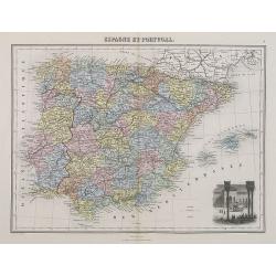
Espagne et Portugal.
A decorative map of Spain and Portugal from Géographie Universelle, Atlas Migeon. With an engraving of the Alhambra in the lower right corner. Published by J. Migeon. Fr...
- $35 / ≈ €33
Place & Date: Paris, 1874
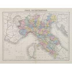
Italie Septentrionale.
A decorative map of northern Italy from Géographie Universelle, Atlas Migeon, published by J. Migeon.From one of the last decorative atlases published in the 19th centur...
- $25 / ≈ €23
Place & Date: Paris, 1874

Nieuwe kaart van het Koningrijk der Nederlanden. . .
Uncommon map of the Netherlands prepared by J.S. Smulders and P. H. Witkamp and lithographed by Z.M. den Koning in the Hague. Dated.Showing The Kingdom of the Netherlands...
Place & Date: The Hague, 1874
Plan général des environs de Sébastopol avec indication de la disposition générale de l'armée alliée au 24 octobre / 5 novembre 1854 et du mouvement du prince Gortchakow vers le mont Sapoune.
A very rare panoramic town-plan of the siege of Sebastopol. In lower margin : "Gravé au Dépôt topographique de la Guerre". From "Défense de Sébastopol...
Place & Date: Saint-Pétersbourg / Paris, 1863-1874
Selling price: $750
Sold in 2014

La Pieuvre Germanique.
Scarce lithographed plate not dated, by Eugène Danzanvilliers, printed by Grandremy in Paris. The plate listed by Adhemar is dated 1874. Eugène Danzanvilliers was a dra...
Place & Date: Paris, 28 Quai de la Rapée, c.1874

La pericolante ostinata. Papagallo No. 20 Anno II.
Design by Augusto Grossi. Taken from the Italian satirical newspaper Il Papagallo, a satirical magazine founded in January 1873 by Augusto Grossi (1835-1919), which speci...
Place & Date: Bologne, 1874

Sint Catharinakerk te Eindhoven.
Uncommon woodblock engraving of St.Catharina church of Eindhoven, built by the well-known architect P.Cuijpers. Published in Katholieke Illustratie.The "katholieke i...
Place & Date: 'sHertogenbosch, Henri Bogaerts, 1875
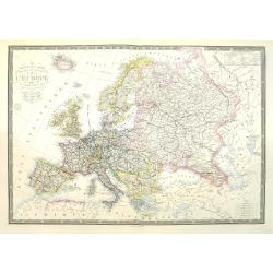
Nouvelle carte physique et politique de l'Europe. Les limites d'états.
Very large, uncommon updated version of the map of Europe prepared by H. Brué and updated by A. Vuillemin. In lower margin "Nouvelle edition" and a date (1875)...
Place & Date: Paris, 1875
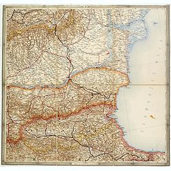
(Untitled map of western shores of the Black Sea, with Bulgaria, Roumenia.)
Untitled map of western shores of the Black Sea, with Bulgaria, Roumenia. The map has elaborate floral borders. Prepared by Josef Schlacher in Vienna and published by K.K...
- $150 / ≈ €140
Place & Date: Vienna, K.K. Militär Geografisches Institut, 1875
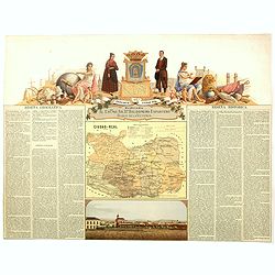
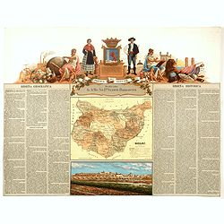
Provincia de Ciudad-Real.
Chromolithography published in "Atlas geográfico histórico de las Provincias de España". Map made by J. Reinoso, Dedicated to Excmo. Sr. Dn. Baldomero Espart...
- $120 / ≈ €112
Place & Date: Madrid, c. 1875
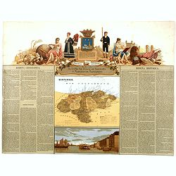
Provincia de Santander.
Chromolithography published in "Atlas geográfico histórico de las Provincias de España". Map engraved by J. Reinoso, Dedicated to Excmo. Sr. Duque de Santona...
- $120 / ≈ €112
Place & Date: Madrid, c. 1875
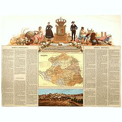
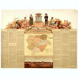
Provincia de Caceres.
Chromolithography published in "Atlas geográfico histórico de las Provincias de España". Map made by M. Vierge, Dedicated to Excmo. Sr. Dn. Cipriano Segundo ...
- $120 / ≈ €112
Place & Date: Madrid, c. 1875
Provincia de Badajoz.
Chromolithography published in "Atlas geográfico histórico de las Provincias de España". Map engraved by M. Vierge, Dedicated to Ilmo. Sr. Dn. Vicente Barran...
- $120 / ≈ €112
Place & Date: Madrid, c. 1875
Provincia de Albacete.
Chromolithography published in "Atlas geográfico histórico de las Provincias de España". Map made by M. Vierge, Dedicated to Ilmo. Sr. Dn. Vicente Barrantes....
- $60 / ≈ €56
Place & Date: Madrid, c. 1875

Société de la Charité Maternelle à Paris. Plan de le ville de Paris, Divisé par Quartiers avec Nomenclature.
>Rare atlas de Paris dressé par E. Devrainne, divisé en 80 quartiers et colorié par Le Roux (Le Roux pinxit). Illustré d'une page de titre aux armes de Paris avec ...
Place & Date: Imprimerie Mercier, Clichy, 1876
![[Schwarzes Meer] Nr 1](/uploads/cache/37946-250x250.jpg)
[Schwarzes Meer] Nr 1
Uncommon map of the Black Sea and Crimea. In lower part a scale. Prepared by Friedrich Handtke (1815-1879). Map set in a decorative border.
- $120 / ≈ €112
Place & Date: Glogau, Leipzig, 1877
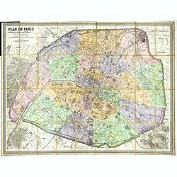
Plan de Paris A l'Echelle de 2 Millim. pour 2.5 Metres . . . Indiquant les Nouveaux percements et les changements de mons de Voies publiques Avec Plans Supplmentaries Pour Les Bois De Boulogne et De Vicennes . . .
Magnificent map of the urban redevelopments planned for Paris at the end of the 19th century. The map has been updated, with insets showing supplemental plans for the Boi...
- $600 / ≈ €561
Place & Date: Paris, 1878

Wandkarte des Deutsches Reiches zum Schul und Comptoir-Gebrauch. . .
School wall map of Germany, Poland, Low Counties, Bohemia printed in chromo lithography with contemporary hand coloring to borders. Published by "Stich und Druck der...
Place & Date: Berlin, Dieter Reimer, 1878
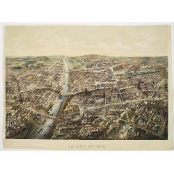
Angers 1878.
Large bird's-eye view of Angers after Mollay and lithographed by Muller.
- $250 / ≈ €234
Place & Date: Paris, Lemercier, ca. 1878

Miss Cora Europea. Papagallo No. 35. Anno VI.
Miss Europa taming the lion (Russia) with other nations shown as animals. Design by Augusto Grossi. Taken from the Italian satirical newspaper Il Papagallo, a satirical m...
Place & Date: Bologne, 1878
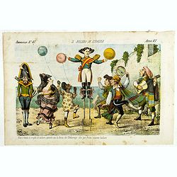
Il bolero in Ispagnia. Papagallo No. 42. Anno VI.
About Spanish expansion, with balloons symbolizing Cuba, Havana, Cortes. Taken from the Italian satirical newspaper Il Papagallo, a satirical magazine founded in January ...
Place & Date: Bologne, 1878
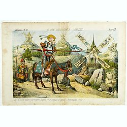
Il Don Cihsciotte a complici. Papagallo No. 48. Anno VI.
Taken from the Italian satirical newspaper Il Papagallo, a satirical magazine founded in January 1873 by Augusto Grossi (1835-1919), which specialized in color-printed ca...
Place & Date: Bologne, 1878

La Piovra Russa. Carta Serio-Comica Pel 1878.
Very rare political caricature map by Grossi of the nations of Europe, published in Bologna in the supplement of the newspaper "Le Perroquet / Al papagallo, N° 15, ...
Place & Date: Bologne, 14 avril 1878
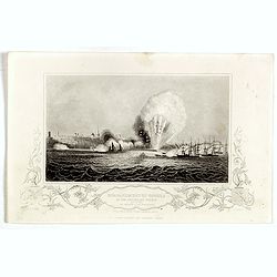
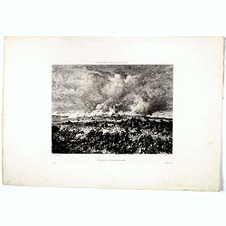
Bombardment of Odessa by the English and French April 22 1854, explosion on the imperial mole . . .
Scene from the Crimea war, showing a bombardment of Odessa, 22nd April 1854 (during Crimean War, 1853-56), by English and French forces, explosion imperial mole (breakwat...
- $30 / ≈ €28
Place & Date: London, ca. 1879

Sint Catharinakerk te Eindhoven
Uncommon print of St.Catharina church of Eindhoven, built by the well-known architect P.Cuijpers. Published in Katholieke Illustratie .
- $85 / ≈ €80
Place & Date: 'sHertogenbosch, 1880
![Sint-Catharinakerk te Eindhoven [with plan]](/uploads/cache/28813-250x250.jpg)
Sint-Catharinakerk te Eindhoven [with plan]
Uncommon wood engraved print of St.Catharina church in Eindhoven, built by the well-known architect P.Cuijpers. Published in Kunstkronijk. This wood engraving is similar ...
- $85 / ≈ €80
Place & Date: Amsterdam, c.1880

Kasteel Croij.
Decorative lithography of the castle of Croij.
Place & Date: Den Haag, 1880

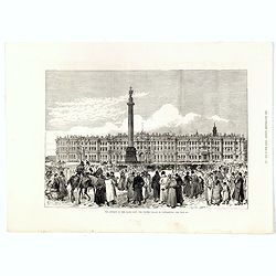
The attempt on the Czar's life: the Soltykoff dorway of the Winter Palace . . .
A panorama of the Winter Palace published in the Illustrated London News of 1880.
- $20 / ≈ €19
Place & Date: London, 28 February, 1880
The attempt on the Czar's life: The Winter Palace, St Petersburg.
A panorama of the Winter Palace with an attempt on the Czar's life published in the Illustrated London News of 28 February, 1880.
- $15 / ≈ €14
Place & Date: London, 28 February, 1880
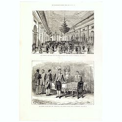
The attempt on the Czar's life: The Grand Ball-Room . . .
A panorama of the Winter Palace with an attempt on the Czar's life published in the Illustrated London News of 28 February, 1880.
- $15 / ≈ €14
Place & Date: London, 28 February, 1880
Porte Ste Barbe.
View of the gate of St. Barbe. Title in Russian and French.
- $50 / ≈ €47
Place & Date: Russia, ca. 1880
Bataille de la Moskova.
Etching of a battle in which Napoleon's army fought the Russian army of general Kutuzov on 7 September 1812.Etched by Auguste II. Boulard (1852–1927) after a painting b...
- $50 / ≈ €47
Place & Date: Paris, 1880
Oro-Hydrographische Kaart van Europa.
One of the earliest thematic maps of Europe published in the Netherlands from "Atlas der natuurkundige aardrijkskunde. . .". prepared by Nicolaas Wilhelmus Post...
- $35 / ≈ €33
Place & Date: Amsterdam, C.L. Brinkman, 1883
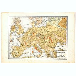
Geologische Kaart van Middel- en Zuid-Europa.
One of the earliest thematic maps published in the Netherlands from "Atlas der natuurkundige aardrijkskunde. . .". prepared by Nicolaas Wilhelmus Posthumus. Wit...
- $35 / ≈ €33
Place & Date: Amsterdam, C.L. Brinkman, 1883

Wandkarte von Europa von H.Berghaus. . .
Large wall map of Europe printed in chromo-lithography. Prepared by Heinrich Berghaus and published by Justus Perthes in Gotha.Heinrich Berghaus, with support of Alexande...
Place & Date: Gotha, Perthes, ca.1885
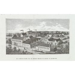
De luciferfabriek van de Heeren Mennen en Krunen te Eindhoven.
Wood engraving published in "Katholieke Illustratie", showing the match factories of Mennnen en Krunen in Eindhoven. Founded in 1870 by banker Christiaan Mennen...
- $40 / ≈ €37
Place & Date: s-Hertogenbosch, H.Bogaerts, ca. 1885
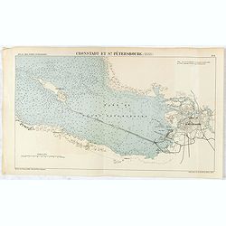
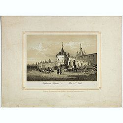
Cronstadt et St. Petersbourg.
Detailed plan of the port and city of St. Petersburg including Kotlin Island and the fortified town of Kronstadt.
- $35 / ≈ €33
Place & Date: Paris, 1888
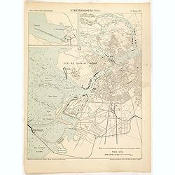
St. Pétersbourg (1888).
Map of St. Petersburg from a French multi volume atlas published by the Ministere des Travaux Publics (Ministry of Civil Engineering), called "Atlas des ports étran...
- $120 / ≈ €112
Place & Date: ?Paris, Imprimerie Nationale 1884-1889

Russia & Poland.
Charming, folding map of Russia and Poland, giving a detailed overview of Europe from Baltic to Caspian Sea. Railways and rivers prominently delineated.In lower left a ke...
Place & Date: London, ca. 1890
![[Voyage en Suisse / Reise die Schweiz.]](/uploads/cache/48396-250x250.jpg)
[Voyage en Suisse / Reise die Schweiz.]
A first edition children's folding board game of Switzerland and its many places and sights to visit. Although it is missing most of its original components (dice, cards,...
Place & Date: Switzerland, 1891

Map of Russia and Poland.
Charming, folding map of Russia, Poland and Baltic States, still in its original publisher's blind stamped linen wrapper with yellow label. With yellow advertisements at ...
Place & Date: London, ca. 1894
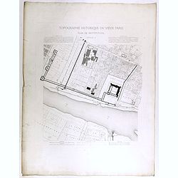
Topographie historique du vieux Paris / Plan de restitution Feuille V.
Copper engraved plan centered on Louvre by Jean-Joseph Sulpis (1826–1911) after a model by Adolphe Berty. Plate 5 from "Topographie historique du vieux Paris"...
Place & Date: Paris, 1866-1897
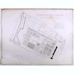
Topographie historique du vieux Paris / Plan de restitution Feuille V bis.
Copper engraved plan centered on gardens of the Louvre by Jean-Joseph Sulpis (1826–1911) after a model by Adolphe Berty. Plate 5bis from "Topographie historique du...
Place & Date: Paris, 1866-1897
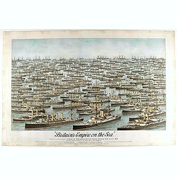
Britain's Empire on the Sea. Dedicated to Captain the Right Honourable Lord Charles Beresford...
A very decorative and large chromolithographed plate showing all the effective strength of the British navy with the name and class of each ship shown beneath, except for...
- $750 / ≈ €702
Place & Date: Portsea, ca. 1897
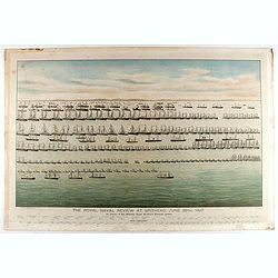
The Royal Naval review at Spithead, June 26th, 1897. In Honour of Her Majesty Queen Victoria's Diamond Jubilee.
A very decorative and large chromolithographed plate showing a line up of international vessels at Spithead, June 26th, 1897 In Honour of her Majesty Queen Victoria'a Dia...
- $750 / ≈ €702
Place & Date: Portsea, ca. 1897
![[Map of the Alps].](/uploads/cache/46164-250x250.jpg)
[Map of the Alps].
Alexey Afinogenovich Ilyin was a lieutenant general and cartographer (1832-1889). In 1856, after graduating from the Academy of the General Staff, he was at the military ...
- $45 / ≈ €42
Place & Date: St. Petersburg, 1899
![[Lake Garda and its surroundings].](/uploads/cache/46166-250x250.jpg)
[Lake Garda and its surroundings].
Alexey Afinogenovich Ilyin was a lieutenant general and cartographer (1832-1889). In 1856, after graduating from the Academy of the General Staff, he was at the military ...
- $100 / ≈ €94
Place & Date: St. Petersburg, 1899
![[France - The Netherlands - Belgium].](/uploads/cache/46168-250x250.jpg)
[France - The Netherlands - Belgium].
Alexey Afinogenovich Ilyin was a lieutenant general and cartographer (1832-1889). In 1856, after graduating from the Academy of the General Staff, he was at the military ...
- $50 / ≈ €47
Place & Date: St. Petersburg, 1899
![[The United Kingdom - Sweden, Norway, Denmark].](/uploads/cache/46169-250x250.jpg)
[The United Kingdom - Sweden, Norway, Denmark].
Alexey Afinogenovich Ilyin was a lieutenant general and cartographer (1832-1889). In 1856, after graduating from the Academy of the General Staff, he was at the military ...
- $50 / ≈ €47
Place & Date: St. Petersburg, 1899
![[Oxford Canal from Oxford to Coventry].](/uploads/cache/37232-250x250.jpg)
[Oxford Canal from Oxford to Coventry].
Manuscript map covering the Oxford Canal. Orientated East to the North. The Oxford Canal is a 78-mile-long (126 km) narrow canal in central England linking Oxford with Co...
- $140 / ≈ €131
Place & Date: ca. 1900
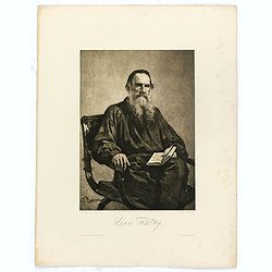
Léon Tolstoy.
Etching by Gustaf Frank after a painting of Ilya Repin (1887). Gustav Frank (1859-1923) attended school in Vlasim, where he learned to draw from Cenka Schneider. Then he ...
- $50 / ≈ €47
Place & Date: Vienna, 1900
![[West Central London from Booth's Poverty Map of London]](/uploads/cache/40267-250x250.jpg)
[West Central London from Booth's Poverty Map of London]
A map of West Central London, one section (of twenty) of an extended version of the incredibly influential Poverty Map, originally published in Charles Booth's 'Life and ...
Place & Date: London, 1900
![[map printed on a tissue] The British remedy for coughs and colds. Owbridge's lung tonic.](/uploads/cache/40288-250x250.jpg)
[map printed on a tissue] The British remedy for coughs and colds. Owbridge's lung tonic.
Handkerchief showing a map of Europe and part of Asia continent printed on a tissue. OWBRIDGE’S LUNG TONIC, THE BRITISH REMEDY FOR COUGHS AND COLDS.Walter Thomas Owbrid...
- $400 / ≈ €374
Place & Date: London, ca. 1900
![[Les anciennes provinces Françaises à la ville de Saint Denis].](/uploads/cache/41681-250x250.jpg)
[Les anciennes provinces Françaises à la ville de Saint Denis].
Nine small chromolithography's trade cards for Ville de Saint Denis, each with French regions and places, with description in French on each verso.Cards of the regions : ...
Place & Date: Paris, circa 1900
![[Les anciennes provinces Françaises à la ville de Saint Denis].](/uploads/cache/41683-250x250.jpg)
[Les anciennes provinces Françaises à la ville de Saint Denis].
Nine small chromolithography trade cards for Ville de Saint-Denis, each with French regions and places, with description in French on each verso.Cards of the regions: Lor...
Place & Date: Paris, circa 1900
![[Les anciennes provinces Françaises à la ville de Saint Denis].](/uploads/cache/41684-250x250.jpg)
[Les anciennes provinces Françaises à la ville de Saint Denis].
Nine small chromolithography's trade cards for Ville de Saint Denis, each with French regions and places, with description in French on each verso.Cards of the regions : ...
Place & Date: Paris, circa 1900
![[Map of Grodno gubernia.]](/uploads/cache/81813-250x250.jpg)
[Map of Grodno gubernia.]
Карта Гродненско&...
- $450 / ≈ €421
Place & Date: Sankt Peterburg, 1850-1900
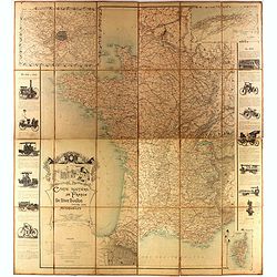
Carte routière de France de Dion Bouton spéciale pour automobiles
Highly decorative folding wall map of France in a scale of 1 : 800 000. In the upper left hand corner an inset plan of Paris, upper right Algeria and lower right map of C...
- $1500 / ≈ €1404
Place & Date: Paris, J. Barreau, 1900
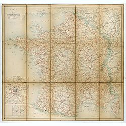
Carte nationale des routes de la France.
Map of the national roads in France, engraved and published by Regnier et Dourdet. Four inset maps of which three shows the three largest cities in France and one shows C...
- $300 / ≈ €281
Place & Date: Paris, ca. 1900
Kasteel Heeswijk.
Very fine etching of the Castle of Heeswijk, by the well-known etcher Ludwig Willem Reymert Wenckebach. He was born in The Hague on 12 January 1860 and died in 1937. The ...
Place & Date: Amsterdam, 1901
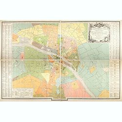
Plan des paroisses de Paris avec la distinction des parties éparses qui en dépendent dressé... par J. Junié, Ingén. Géogr. De Monseigneur l'Archeveque et géomètre des Eaux et forêts de ...
Large wall map size plan of Paris in 4 separate sheets, if joined forming a plan of Paris of 93 x 60cm. This plan is a 1904 version of a manuscript plan drawn in 1786 by ...
Place & Date: Paris, Service des Travaux historiques de la Ville de Paris, 1904

Excelsiori (Rana N. 28 - Cent. 20).
"After so many wars and so many troubles, young Russia, in a more serene glaze all the beautiful sun of freedom you will enjoy ... ". Fascinating allegorical sa...
Place & Date: Bologna, 1905
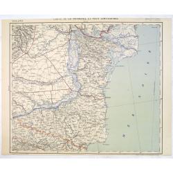
Carte de la Roumanie et Pays limitrophes. Odessa. GALATZ.
Very detailed (1:750.000) map centered on Constanta, with the river Danube in Romania. Made after an Austrian map. The French Service géographique des armées was founde...
Place & Date: Paris, 1908

(Postcard of Europe)
During the Great War, when the only means of communicating news to the masses was by newspapers and weekly illustrated magazines, the ‘war’ or 'military' picture post...
Place & Date: Moscow, 1914
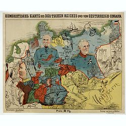
Humoristische Karte von Europa im Jahre 1914.
A satirical map of Europe with a title in German that marks the outbreak of the First World War, probably conceived between August and October 1914. Lehmann-Dumont was no...
Place & Date: Dresde, Leutert & Schneidewind, ca. 1914
![[Goose game board] Le 1914 Edition pochette.](/uploads/cache/47215-250x250.jpg)
[Goose game board] Le 1914 Edition pochette.
Goose game in the form of a folding map of north of France and Belgium, with part of England, Germany, Holland and Luxembourg.
- $450 / ≈ €421
Place & Date: Paris, 1914

Mappa Humoristico da Europa.
A really unusual and lovely map, published in Portugal at the outbreak of The Great War in 1914. This outbreak of war in Europe was the result of a complex sequence of ev...
Place & Date: Lisbon, 1914

Völker Europas wie schön sind eure Geschichter. (World War I post card)
During the Great War, when the only means of communicating news to the masses was by newspapers and weekly illustrated magazines, the ‘war’ or 'military' picture post...
Place & Date: Germany, 1915
![[Cloth Map of Europe]](/uploads/cache/47148-250x250.jpg)
[Cloth Map of Europe]
Anglo-centric cloth map of Europe produced during WWI.Serbia, the spark that lit the conflagration of World War One, isn’t even labeled on this interesting cloth map of...
- $550 / ≈ €515
Place & Date: London, c. 1915
![[2 maps] Das Europa der Zukunft... / Das heutige Europa…[The Europe of the Future / The Europe of Today]](/uploads/cache/48735-250x250.jpg)
[2 maps] Das Europa der Zukunft... / Das heutige Europa…[The Europe of the Future / The Europe of Today]
A pair of very scarce WWI German maps highlighting Europe as it currently was, and Europe as it may become. The maps were produced as part of an 8 page booklet produced b...
- $2750 / ≈ €2573
Place & Date: Paris, 1917

Mapa Polski i Krajów Osciennych - Wydanie trzecie. Opracowal Stanislaw Max. Wydani M. Arcta.
‘The Birth of Modern Poland on a map’ - an excellent wall map of Poland and surrounding regions, published in Warsaw near the end of World War I, when Poland’s fate...
- $1000 / ≈ €936
Place & Date: Warsaw, [H. Sklodowski], 1918
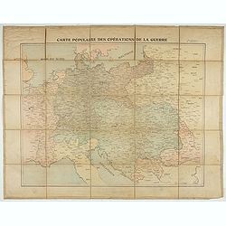
Carte populaire des opérations de la guerre. 2ème édition.
Folding map. War Operations Map showing a part of Europe, published by Epinal.
- $150 / ≈ €140
Place & Date: Paris, ca. 1919
![[This is Great Brittain to-day - Cambridge]](/uploads/cache/43009-250x250.jpg)
[This is Great Brittain to-day - Cambridge]
Chromolithoghraphed plate showing a fancy depiction of the court yard of a British University (Cambridge). A text in Arabic language explaining about the 20 universities ...
Place & Date: Arabia, ca. 1920

The Wonderground Map of London.
A large and pictorially striking 'Wonderland' advertising poster on behalf of the London Underground, published in the late 1920s. The poster was very popular, and ran fo...
- $4000 / ≈ €3743
Place & Date: London, ca 1927
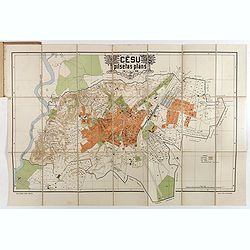
Cesu un apkartnes vadonis ar Cesu pilsetas planu. . .
Uncommon and detailed plan of Cesis and its direct surroundings. Cesis is a town in northeastern Latvia, built in the 13th century and one of the best-preserved medieval ...
- $550 / ≈ €515
Place & Date: Cesu, 1928
Femme de Barèges (106, La Gascogne).
Plate published in "Les costumes régionaux de France" with illustrations by Gratiane de Gardilanne (painter and designer) and Elisabeth Whitney Moffat.Costume ...
- $75 / ≈ €70
Place & Date: Paris, Editions du Pégase, 1929

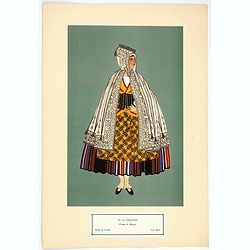
Laitière Bordelaise, d'après de Gallard (110, La Guyenne).
Plate published in "Les costumes régionaux de France" with illustrations by Gratiane de Gardilanne (painter and designer) and Elisabeth Whitney Moffat.Costume ...
- $75 / ≈ €70
Place & Date: Paris, Editions du Pégase, 1929

Hongarije.
Poster made for Hungarian Tourist association. The uncommon Dutch version of this fine poster to promote Hungary in the 1930's. Arisztid Uher was a graphic designer. He d...
Place & Date: Budapest, KLOSZ / Sohn., ca. 1930

(Art déco gouache with winter scene of The Palace of Westminster )
Outstanding "art deco" gouache (unsigned) from the workshop of "Robert Pichon. Ateliers de Dessin et Lithographie – 10, rue Rochechouart – Paris. The ...
Place & Date: Paris, ca. 1930
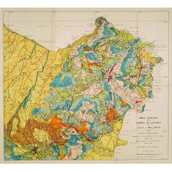
Mapa geologic de les serres de Llevant de l'illa de Mallorca.
Geological map showing part of the island Mallorca Manacor, Son Severa, Capdepera.. After a design by D.Ferrá. Dibuxá, in lower right corner: D.Ferrà. Dibuxá.Provenan...
- $150 / ≈ €140
Place & Date: Palma, 1932