Browse Listings in Europe
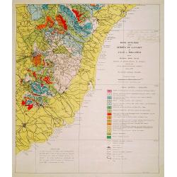
Mapa geologic de les serres de Llevant de l'illa de Mallorca.
Geological map showing part of the island Mallorca Felanitx, Santanyi, Porto Cristo, Porto Colom.., including a legend with geological and topographical signs. After a de...
- $100 / ≈ €94
Place & Date: Palma, 1932
![Environs de Raguse (Dubrovnik). Deuxième Feuille. Canal de Calamota (Kolocep).. [277]](/uploads/cache/23473-250x250.jpg)
Environs de Raguse (Dubrovnik). Deuxième Feuille. Canal de Calamota (Kolocep).. [277]
This large-scale coastal chart shows the stretch of the Dalmatian coast between Slano as far as the island of Kolocep, the southernmost inhabited island in Croatia. With ...
- $200 / ≈ €187
Place & Date: Paris [1877] corrected to 1932
![Mer Adriatique. Côte Orientale. De l'Ile Meleda à Antivari.. [3552]](/uploads/cache/23471-250x250.jpg)
Mer Adriatique. Côte Orientale. De l'Ile Meleda à Antivari.. [3552]
This large scale coastal chart shows the stretch of Dalmatian coast between the island Mljet in Croatia as far as Ulcinj (Montenegro). With latitude and longitude scales,...
- $200 / ≈ €187
Place & Date: Paris [1877] corrected to 1934
![Mer Adriatique. Partie Sud.. [3976]](/uploads/cache/23549-250x250.jpg)
Mer Adriatique. Partie Sud.. [3976]
This large scale coastal chart centered on the southern part of the Adriatic sea. Showing the Dalmatian coast between Split in Croatia as far as the northernmost tip of C...
- $200 / ≈ €187
Place & Date: Paris [1883] updated for 1935
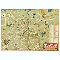
Moscow.
A nice colored lithographic town plan of the Russian capital, in English, published in 1938 in order to promote the U.S.S.R's cultural image overseas during Stalin's term...
- $750 / ≈ €702
Place & Date: Moscow, ca 1938
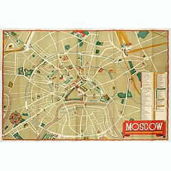
Moscow.
Fantastic pictorial map of Moscow designed to draw tourists to the new Soviet Union.The cultural vitality of Moscow in the early years of the Soviet Union is the focal po...
- $750 / ≈ €702
Place & Date: Moscow, c. 1938
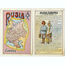
Rusia Europae U.S.S.R.
Detailed map of Russia. Unique manuscript map of Russia. Award-winning manuscript card, prepared by Antonio Raggio for the 11th Congreso de la Union Postal Universal (Wor...
- $450 / ≈ €421
Place & Date: Buenos Aires, 1939
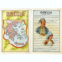
Grecia.
Unique manuscript map of Greece. Award-winning manuscript card, prepared by Antonio Raggio for the 11th Congreso de la Union Postal Universal (World Postal Congress) Expo...
- $250 / ≈ €234
Place & Date: Buenos Aires, 1939

L'Europe en Sept 1939. Ille terrarum mihi angulus ridet.
A rare oversized serio-comic map of Europe at the start of the Second World War depicting stereotypes of 31 countries, as listed in the key lower right, including Brit...
Place & Date: Bruges, Leon Burghgraeve, 1939
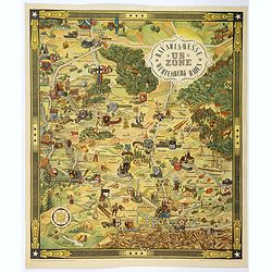
US ZONE. Bavaria, Hesse, Wurtemberg, Baden.
An unusual decorative pictorial map, from the years immediately following World War II, depicting the American Zone of Occupation in southern Germany. It portrays rural ...
Place & Date: Munich, 1940

US ZONE. Bavaria, Hesse, Wurtemberg, Baden.
An unusual decorative pictorial map, from the years immediately following World War II, depicting the American Zone of Occupation in southern Germany. It portrays rural ...
- $450 / ≈ €421
Place & Date: Munich, 1940

Karte der Ukraina.
A large political, economical and transportation map of Ukraine, printed three months after the beginning of the WW II in Ukraine. Shows the newest borders, streets and r...
Place & Date: Vienna: Freytag u. Bernd u. Artaria August 1941

Languedoc - Foix Roussillon.
Very decorative, informative map of Languedoc - Foix Roussillon region in south eastern France. Including the towns of Carcassonne, Montpellier, Albi, Toulouse, etc.The m...
Place & Date: France, 1943

Guyenne - Gascogne.
Very decorative, informative map of Guyenne and Gascogne region in France. The map is filled with buildings, animals, figures and two locals. With a large compass rose in...
Place & Date: France, 1943

Group of 21 watercolors of scenes in Iceland, included are vulcanos like Eyjafjallajokull, Öræfajökull, etc.
A group of water colors made during visits of the artist F. de Boungne to Iceland, among them are contemporary artistic impressions of the now world-famous volcano Eyjafj...
Place & Date: Iceland, 1933-1944
![Map of the Occupied Areas. Carte des Zones d'Occupation. Der Besatzungs-Zonen mit Neuen Postleitgebieten. Karta Okkupacionnych Zon [in Cyrillic.]](/uploads/cache/42060-250x250.jpg)
Map of the Occupied Areas. Carte des Zones d'Occupation. Der Besatzungs-Zonen mit Neuen Postleitgebieten. Karta Okkupacionnych Zon [in Cyrillic.]
A poster map of Germany and Austria showing the Allied occupation zones as agreed at the Potsdam Conference after the end of the Second World War, with an inset detail of...
- $350 / ≈ €328
Place & Date: Frankfurt-am-Maine: Atlanta-Service, 1946
MEMORANDUM Vlade Demokratske Federativne Jugoslavije po pitanju Juliske Krajine i drugih jugoslavenskih teritorija pod Italijom.
Memorandum of the government of the Democratic Federative Yugoslavia concerning the questions of the Jilian March and other Yugoslav territories under Italy.Julian March ...
- $300 / ≈ €281
Place & Date: London, 1946

Langwasser Stanislau Neu Brandenburg Mei 1942 Juni 1945
Map met reproducties van crayontekeningen van Krijgsgevangenschap in Langwasser, Stanislau en Neu-Brandenburg, Mei 1942 -juni 1945.Uitgegeven april 1948 door het Minister...
Place & Date: Den Haag, April 1948
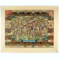
Cambridge.
Though the city had endured significant damage during the Second World War, which ended only a few years prior to publication, there is little indication of the destructi...
- $550 / ≈ €515
Place & Date: London, 1948

Air France - Corse.
Corsica poster for Air France, by Raoul Éric Castel (1915 - 1997) and published by Havas. Signed has work with Éric, he was born in Lyon and made many fine travel poste...
- $1200 / ≈ €1123
Place & Date: Imprimerie Perceval Paris, ca. 1940-1950
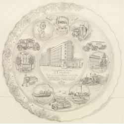
Shell : 9 Februari 1911-1951.
Decorative design-drawing in lead pencil offered to mr. J.E. Talens for his 40 years jubilee at the Shell foundation : Aangeboden aan J. E. Talens ter gelegenheid van zij...
Place & Date: Gouda, ca. 1951
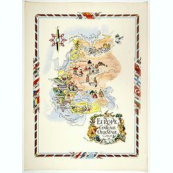
L'Europe Centrale et Orientale.
Pictorial tourism poster of central and eastern Europe, showing different life scenes relative to the culture's country.Learn more about pictorial maps. [+]
- $100 / ≈ €94
Place & Date: Paris, 1951
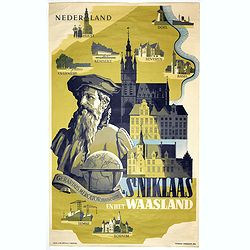
Sint Niklaas en het Waasland Gerardus Mercator Museum.
Poster showing a portrait of Gerard Mercator, set behind a globe and the town hall of St. Niklaas. Showing a map of the region containing pictorial vignets of Overmere, K...
- $500 / ≈ €468
Place & Date: Brussels, 1951
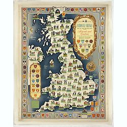
National saving map og the British Isles . . .
A brilliantly eccentric poster showing the festivals, customs of the British Isles with the arms and seals of the counties.Founded in 1861, National Savings is a state-ow...
- $450 / ≈ €421
Place & Date: London, 1951

A map of the British Army with battle honours and militray achievements and Regimental Badges . . .
Shows English County Regiments, Battle Honours and Military Achievements. Bordered by Regimental Badges.A fascinating piece of British history.Read more about Pictorial M...
Place & Date: London, 1952
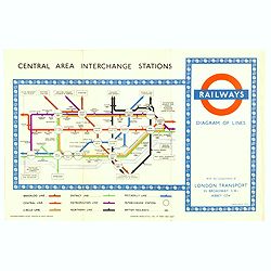
1953 Harry Beck London Underground map.
Published in the Queen's coronation year. A London Underground map (double sided).
- $150 / ≈ €140
Place & Date: London, 1953

Forteresse Ile Ste Marguerite.
Nice drawing of a stronghold Ste Marguerite. The Île Sainte-Marguerite is the largest of the Lérins Islands, about half a mile off shore from the French Riviera town of...
Place & Date: France, Provence, after 1960
![[Fan shaped shopping guide to Stockholm.]](/uploads/cache/44788-250x250.jpg)
[Fan shaped shopping guide to Stockholm.]
A highly unusual and interesting vintage fan-shaped map of Stockholm to illustrate a 'Shopping guide to Stockholm'. Text written in English. With ten fold-out panels prin...
- $200 / ≈ €187
Place & Date: Stockholm, 1960
![[Pictorial map of Georgia (Caucasus)].](/uploads/cache/44292-250x250.jpg)
[Pictorial map of Georgia (Caucasus)].
A scarce pictorial map of a region in Georgia in the Caucasus. Map is entirely in Russian, complete with legend at base of map, with small thumbnail pictures and symbols ...
- $150 / ≈ €140
Place & Date: Moscow, 1963
![[Pictorial map of Georgia (Caucasus)].](/uploads/cache/47135-250x250.jpg)
[Pictorial map of Georgia (Caucasus)].
A scarce pictorial map of a region in Georgia in the Caucasus. Map is entirely in Russian, complete with legend at base of map, with small thumbnail pictures and symbols ...
- $150 / ≈ €140
Place & Date: Moscow, 1963
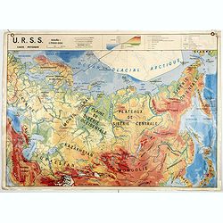
U.S.S.R. Carte Physique. / U.S.S.R. Carte Population.
An unusual school map with on one side a physical map of Russia on verso a map of Russia according to population. Prepared by Pierre Serryn (1916-2002) who was professor ...
- $200 / ≈ €187
Place & Date: St-Germain-en-Laye, 1965
U.S.S.R. Carte Agricole. / U.S.S.R. Carte Industries et communications.
An unusual school map with on one side an agricultural map of Russia on verso a map of Russia showing communication an according to population. Prepared by Pierre Serryn ...
- $200 / ≈ €187
Place & Date: St-Germain-en-Laye, 1965
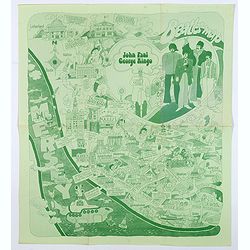
Beatles Map.
A lovely example of the scarce 'Beatles Map' of Liverpool, published in 1974 to commemorate the buildings and places where the Beatles started their stellar careers. The ...
- $750 / ≈ €702
Place & Date: Liverpool, 1974
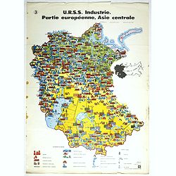
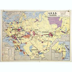
U.R.S.S. Industrie. Partie européenne, Asie centrale. (3)
Map of Eastern Russia. Propaganda poster for Russia's industry. Text in French. Editions de l'Agence de presse Novosti".More about War Maps & Propaganda maps [+]
- $100 / ≈ €94
Place & Date: USSR, 1978

U.R.S.S. Energie Eléctrique. (5)
Map of Russia. Publicity poster for Russia's electrical production. Text in French. Editions de l'Agence de presse Novosti".More about War Maps & Propaganda maps...
Place & Date: USSR, 1978
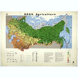
U.R.S.S. Agriculture. (6)
Map of Russia. Propaganda poster for Russia's in and export of industrial goods. With a key in bottom. Text in French. Editions de l'Agence de presse Novosti".More a...
- $100 / ≈ €94
Place & Date: USSR, 1978
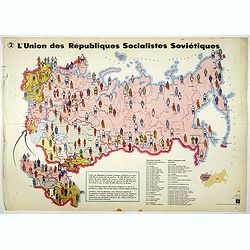
L'Union des Républiques socialistes Soviétiques. (2)
Map of Russia. Propaganda poster showing Russia' s population. With a key. Text in French. Editions de l'Agence de presse Novosti".More about War Maps & Propagan...
- $100 / ≈ €94
Place & Date: USSR, 1978
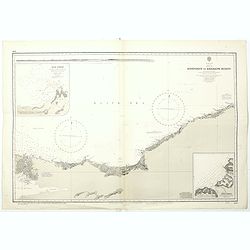
Black sea - Sheet IX - Bosporus to Kerempe Burnu . . .
A highly corrected version of Admiralty chart 2238 originally published 16th June 1854. Edition Date 1980.Detailed chart of Bosporus. With prohibited landing places in pu...
- $100 / ≈ €94
Place & Date: London, 1854-1980