Browse Listings in East Meets West
![[Complete set of maps of Japan] Imperium Japonicum Per Regiones Digestum Sex et Sexaginta Atque Ipsorum Japonensium Mappis Descriptum Ab Hadriano Relando.](/uploads/cache/41590-250x250.jpg)
[Complete set of maps of Japan] Imperium Japonicum Per Regiones Digestum Sex et Sexaginta Atque Ipsorum Japonensium Mappis Descriptum Ab Hadriano Relando.
Complete set of 11 maps Reland's map of Japan, the first map to use Sino-Japanese characters on a European printed map and represents a radical departure from prior Europ...
Date: Amsterdam, 1751
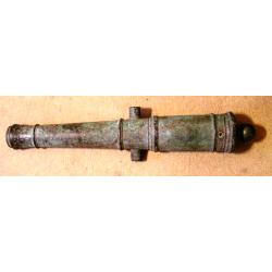
A fine bronze cannon.
Cannon built up of two truncated conuses, differing in size, the steps marked by mouldings shaped as flat bands preceded by ogees: base ring similar; breech with ogee-sha...
Date: Amsterdam, ca. 1755
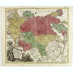
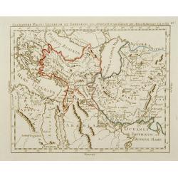
Spatiosissimum Imperium Russiae Magnae juxta recentissimas Observationes Mappa Geographica . . .
This is a decorative map of greater Russia, extending from Livonia in the west to Kamchatka, China, Tibet, Taiwan, Korea, and part of Japan in the east. To the south, it ...
- $1300 / ≈ €1135
Date: Augsburg, 1757
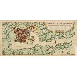
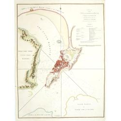
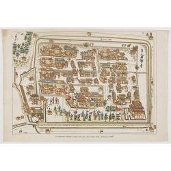
Plan du port et de la ville de Nangasaki.
This plan originates from Charlevoix's work Histoire et description Générele du Japon . His first in 1715 published work was the Histoire de l'etablissement du christia...
- $600 / ≈ €524
Date: Paris, 1760
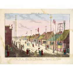
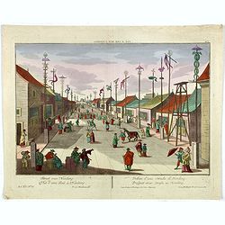
Vue de la Rue des Marchands Chinoises a Nankin.
1760 - OPTICAL PRINT - Illustrating a street in 18th-century Nanjing, one of China’s most important historic capitals.
Date: Augsburg, 1760
Vue d'une Rue Nanking.
A well-known publisher of optical prints, established in Augsburg. After a design by P.van Blankaert.In the eighteenth and nineteenth centuries, there were many popular s...
Date: Augsburg 1760
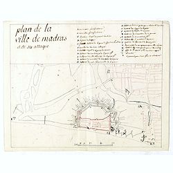
Plan de la ville de Madras et de ses attaques.
Manuscript map, in black, brown and red ink, showing the fortifications of the city of Madras, now Chennai, on the east coast of India, north of Pondicherry.Showing the c...
Date: Paris, ca 1760
![Plan de Gingy, ville et forteresse d'Asie . . . [An Early Manuscript Map of Pondicherry Prior To Its Reconstruction After The Seven Years War.]](/uploads/cache/43006-250x250.jpg)
Plan de Gingy, ville et forteresse d'Asie . . . [An Early Manuscript Map of Pondicherry Prior To Its Reconstruction After The Seven Years War.]
An early manuscript map of Gingy shortly after The Seven Years War, when the French took possession of large part of India.With an extensive key to the left.Gingee Fort o...
- $1500 / ≈ €1309
Date: Paris, 1765
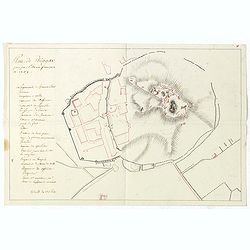
Plan de Thiagar, prise par l'arméé française en 1759.
An early manuscript map of Thiagar. With an extensive unfinished key to the left. The map was drawn shortly after the end of the Seven Years War, when the French took pos...
- $750 / ≈ €655
Date: Paris, 1769
Vue de la Pondichery dans les Indes Orientales
Pondicherry is the capital city of Indian union territory of Puducherry. Pondicherry is situated in Puducherry district of the union territory in India. The vue was produ...
Date: Paris, 1780
Alexandri Magni Imperium et Expeditio per Africam et potissimum per Aslam.
Rare map of the Empire of Alexander the Great, prepared by J.B.Nolin and published by Monhare for his Atlas Général a l'usage des colleges et maisons d'education.. Cent...
Date: Paris, 1783
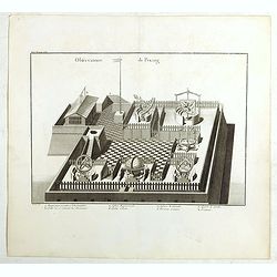
Observatoire de Peking.
The observatory of Mateo Rizzi in Peking, in which there are very large instruments, an Equinoctial Sphere, a Celestial Globe, a Zodiacal Sphere, Azimuthal Horizona, Quad...
Date: Paris, GROSIER Jean-Baptiste, 1785
![[ LANDSKROON ]. Oranda Fune no zu [= Depiction of a Dutch Ship].](/uploads/cache/28003-250x250.jpg)
[ LANDSKROON ]. Oranda Fune no zu [= Depiction of a Dutch Ship].
A very large and extremely detailed Japanese drawing on rice paper of a Dutch ship at the artificial island Deshima, the VOC's outpost in Nagasaki harbour. In the drawing...
Date: Japan, Kansei 4, 2nd month, 9th day, 30 March? 1792
A Plan of the city and harbour of Macao : a colony of the Portugueze, situated at the southern extremity of the Chinese Empire. . .
A large chart of Macao engraved by Benjamin Baker (fl. 1766-1824) and published by George Nicol. The town of Macao is shown in detail, with a 37-point key in English list...
Date: London, 1796
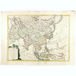
L'Asie divisée dan ses principaux états, empires, et royaumes dréssée et augmentée des plus exactes nouvelles découvertes qui ont fait en plusieurs fois les plus celebres capitaines.
A very rare map of Asia, in the style of Antonio Zatta with a scenic title cartouche, but folio-sized. It comes from a never-finished atlas by the ‘Società Calcografia...
Date: Venise, 1799
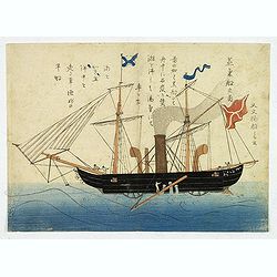
'Jokisen no zu' (Steamboat)
Nagasaki-e original Japanese woodblock print of a Steamboat. The figurehead is a striking detail.Nagasaki-e are Japanese woodblock prints that depict foreigners (Mostly ...
- $3750 / ≈ €3273
Date: Nagasaki, c.1805
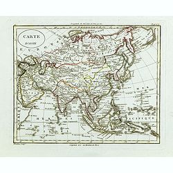
Carte d'Asie.
Fine map of Asia, with an interesting representation of Japan, Hokkaido, Sakhalin Island, Kamchatka, and Korea. Engraved by Alexandre Blondeau, who also worked for Depôt...
- $175 / ≈ €153
Date: Paris, c. 1810
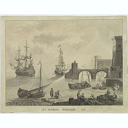
Les environs d'Ostende. XII.
Beautiful view of Oostende. A somewhat fanciful depiction of the harbor of Oostende, with merchant on the foreground and large vessels in the sea. The item is signed (Dre...
Date: Belgium, c. 1811
![Ansicht von Megasaky. [Nagasaki - title also in Russian characters]](/uploads/cache/24829-250x250.jpg)
Ansicht von Megasaky. [Nagasaki - title also in Russian characters]
The print shows Nagasaki harbor with n the foreground the Russian delegation with Krusenstern in a boat with 3 Chinese. Japanese junks and the town of Nagasaki in the ba...
- $1500 / ≈ €1309
Date: St.Petersburg, 1810-1814
![Ansicht der stadt Nangasaky. [Nagasaki - title also in Russian characters]](/uploads/cache/24839-250x250.jpg)
Ansicht der stadt Nangasaky. [Nagasaki - title also in Russian characters]
A lively scene in Nagasaki harbor. In the foreground, Japanese junks and the town of Nagasaki in the background, with the warehouses on Deshima, the trading post of the D...
- $3000 / ≈ €2618
Date: St.Petersburg, 1810-1814
La factorerie chinoise a nagasaki, dans la rue Teng-chan (fondée en 1688).
The Chinese traders at Nagasaki were confined to a walled compound which was located in the same vicinity as Dejima island; and the activities of the Chinese, though less...
- $500 / ≈ €436
Date: Paris, A. Nepveu, 1820
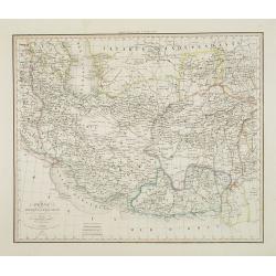
Perse Afghanistan et Balouchistan . . .
Detailed map of Irak and Iran, prepared by A. H. Basset, rue Saint-Jacques, no. 64, Paris and published in Atlas classique et Universel de Géographie . . . .The top thre...
Date: Paris, A.H. Basset, 1828
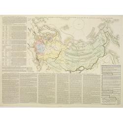
Tablaeu géographique statistique &C. de l'empire Russe actuel en Europe et en Asie avec ses aquisitions graduelles et caractérisées.
Map showing the extension of the Russian Empire at the beginning of the 19th century. Several letterpress notations are present on the map.Surrounding letterpress explana...
Date: Paris, Paul Renouard, 1828

A Chinese official with a ceremonial hat, holding a fan and a silk purse.
A colored wood block print of a Chinese official with a ceremonial hat, holding a fan and a silk purse.
Date: Nagasaki, c. 1830
![Sincapour. [Singapore]](/uploads/cache/23696-250x250.jpg)
Sincapour. [Singapore]
Early view of Singapore after Pâris, engraved in aquatint by Sigismond Himely (1801-1872). The view is drawn looking up the Singapore River from South Boat Quay. It sho...
Date: Paris, Finot, 1835
Macao.
Early view of Macao after Barthelemy Lauvergne (1805-1875) and engraved in aquatint technique by Sigismond Himely (1801-1872). Published as plate 28 in Voyage autour du m...
- $600 / ≈ €524
Date: Paris, Finot, 1835
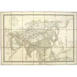
Carte physique et politique de l'Asie. Publiée pour la première fois en 1822 par J. GOUJON. Revue et augmentée par l'éditeur d'après de nouveaux matériaux.
This is a detailed map of Asie. It provides very good details of towns in modern-day Uzbekistan. The region is labeled as "Usbecs." The important cities on the...
Date: Paris, J. Goujon et J. Andriveau, 1837
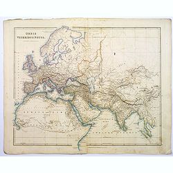
Orbis Veteribus Notus.
This is a detailed steel-engraved map of the ancient world, stretching from Europe eastwards to the Black Sea and beyond, southwards through northern Africa, Arabia, Indi...
Date: London, 1839
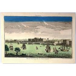
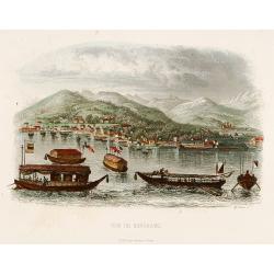
Vue de Nangasaki
View over the town from the water, identifying clearly Deshima with the V.O.C. trading post. Japanese sloops in the fore ground. Engraved by Alp.Boilly.
- $180 / ≈ €157
Date: Paris 1842
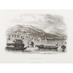
Vue de Nangasaki.
Steel engraved of Nagasaki from the water, identifying clearly Deshima, the V.O.C. trading post and the Dutch flag. Japanese and Chinese sloops in the fore ground. Engra...
- $125 / ≈ €109
Date: Paris, 1842
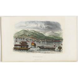
Vue de Nangasaki
View over the town from the water, identifying clearly Deshima with Japanese sloops in the fore ground. Engraved by Alp.Boilly.
Date: Paris, 1842
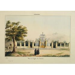
Pondichery - Vue de l'Eglise des Jésuites.
Constructed in 1791, it is regarded as the main mother church of Roman Catholic Archdiocese of Pondicherry and Cuddalore. To one’s surprise, this famous church in Pondi...
- $300 / ≈ €262
Date: Paris, 1843
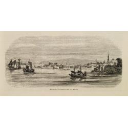
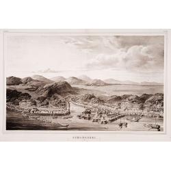
Der Hafen von Nangasaki auf Kiusiu.
A panoramic view of the harbour and city of Nagasaki with extensive shipping.
- $100 / ≈ €87
Date: Germany, 1847
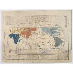
Chikyu Bankoku sankai yochi zenzu setsu. / Sekisui Cho Harutaka. (Map and description of geography of all the countries of the globe).
Reduced version of the famous map "Kaisei chikyu bankoku zenzu" by Sekisui Nagakubo (1717-1801) published ca. 1785, still based on the one by Matteo Ricci. Incl...
- $3500 / ≈ €3055
Date: Tokyo, 1850
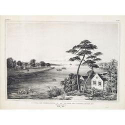
Gezicht op het Meer Tokaitç / Biwa-ko.
View of Lake Biwa near Kyoto.Von Siebold was born in Wurtzburg, in Germany, and worked for the Dutch government as a doctor in Java. In Japan, where Von Siebold arrived i...
- $1500 / ≈ €1309
Date: Leiden, 1832-1852

Simori.
Portrait of Simori.Von Siebold was born in Wurtzburg, in Germany, and worked for the Dutch government as a doctor in Java. In Japan, where Von Siebold arrived in 1823 at ...
Date: Leiden, 1832-1852
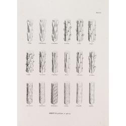
ABIETUM phyllulae et pulvini.s. Tab. 137.
From his famous work 'Flora Japonica'. Von Siebold was born in Würzburg, Germany, and worked for the Dutch government as a physician in Java. In Japan, where Von Siebold...
Date: Leiden, 1852
Factorij der Nederlanders op Firato.. 1609-1641.
Bird's-eye view of Hirado, a trading post of the V.O.C. from 1609 until 1641.Von Siebold was born in Wurzburg, in Germany, and worked for the Dutch government as a doctor...
- $1500 / ≈ €1309
Date: Leiden, 1832-1852
Simonoseki.
Bird's-eye view of Simonoseki, an important trading post in earlier times. Von Siebold was born in Wurtzburg, in Germany, and worked for the Dutch government as a doctor ...
- $1500 / ≈ €1309
Date: Leiden, 1832-1852
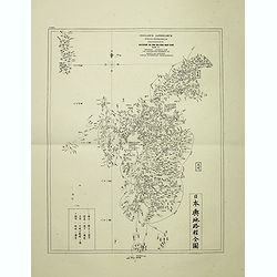
Insularum Japonicarum tabulae geographicae secundum opus NIPPON JO TSI RO TEI SEN TSU Tab. I Kiusui Insularum. . .
Fine map of the island if Kyushu, together with Tsushima Island with the bay of Nagasaki where in 1641 the man-made island of Deshima, trading post of the V.O.C. was est...
- $1000 / ≈ €873
Date: Leiden, 1832-1852
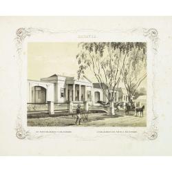
BATAVIA. Het post etablissement te Weltevreden. L'établissement des postes à Weltevreden.
Rare lithographed view of the post office at Weltevreden (Jakarta). Beautiful lithography drawn by Charles Th. Deeleman (1823 - 1884), lithographed by G.J. Bos and printe...
Date: Batavia, 1859-1860

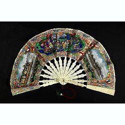
A fan combining views of Hong Kong (right), Canton (center), and Macau.
The fan shows nice images of Macau, Hong Kong and Canton on onside and on verso a garden with 45 characters welcoming a rider on his white horse. Their clothes are height...
Date: China, ca. 1850-1860
A fan combines views of Hong Kong (right), Canton (left), China, ca 1850-1860.
The fan shows nice images of Hong Kong and Canton on onside and on verso a garden with 39 characters welcoming a rider on his white horse. Their clothes are heightened in...
Date: China, ca. 1850-1860
View of Nagasaki, Japan.
A panoramic view of Nagasaki harbour from the Illustrated Times of November 28th., 1863. With accompanying one column descriptive text on verso of Nagasaki.
- $100 / ≈ €87
Date: London, 1863

En Chine.
From the series "Caricatures du Prussien - Guerre des Duchés". Lithographed by Julés Pelcoq.
Date: Paris, 1864
Attaque & prise des forts du Pei-Ho Le 21 Août 1860, par les troupes Françaises et Anglaises.
In 1860, an Anglo-French force gathered at Hong Kong and then carried out a landing at Pei Tang on August 1, and a successful assault on the Taku Forts on August 21.This ...
- $500 / ≈ €436
Date: Paris, ca.1865
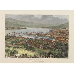
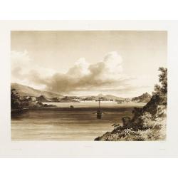
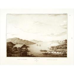
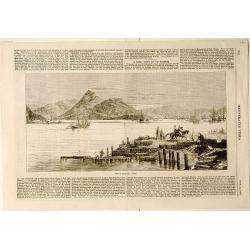
Nagasaki. - Vue générale. Dessin de Taylor, après une photographie.
A bird's-eye view showing Nagasaki Bay. After a photograph by Taylor. Engraved in wood by A.Kohl.Showing the town and natural harbour of Nagasaki.In the harbour the islan...
- $150 / ≈ €131
Date: Paris, 1880

COLLECTION OF HONG KONG MAPS, BOOKS & FLYERS. Including CHINA - HONGKONG surveyed by Captn. Sir Edward Belcher, in H.M.S. Sulphur 1841. Corrected to 1901.
A collection of 30 maps, prints, and publications relating to Hong Kong. Including : - BELCHER, E. Sir, An updated version of this most important nautical chart of Hong K...
Date: London, 1841 - 1901

Designs for two porcelain bowls with Chinese design.
With numbers 4.601, 4.818. In top "Planche N° d'ordre : 03004.Original design created by the Sevres artist Gabriel Fourmaintraux ( 1886 - ) at about 1910 to serve a...
Date: Desvres, 1905 - 1925

Designs for porcelain vases with Chinese motif.
Hand colored design of 13 vases with attractive patterns of a classic Chinese motif. In right "Planche d'aquarelle N° 04004" and the numbers 7.404, 2.074, 8.93...
Date: Desvres, 1905 - 1925

Plan commercial de la Région Saïgon-Cholon.
Decorative publicity plan of Ho Chi Minh City, also known by its former name of Saigon and Cholon, prepared by Ngo-Trinh, surrounded by advertisements of local stores. Th...
Date: Saigon, 1948
