Browse Listings
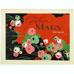
Art déco label for Parfum Mary France.
Lithographed perfume label "Parfum Mary France" laid on original cardboard sheet. A striking example of commercial artworks produced by the artist and graphic d...
Place & Date: Paris, between 1925 and 1930
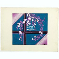
Art déco label for de Neuville, Paris.
Lithographed perfume label " Savon extra fin au jasmin N°1727 " laid on original cardboard sheet. A striking example of commercial artworks produced by the art...
Place & Date: Paris, between 1925 and 1930
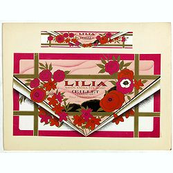
Art déco label Paul Tranoy, Paris.
Lithographed perfume label " Lilia Savon extra fin soap - Œillet (carnation) Paul Tranoy Paris N°725 " laid on original cardboard sheet. A striking example of...
Place & Date: Paris, between 1925 and 1930
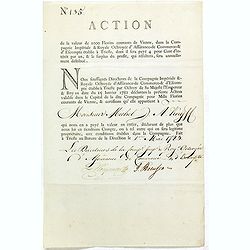
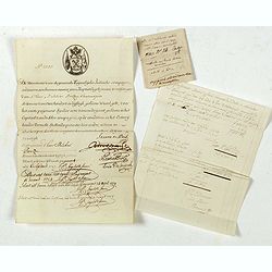
Share of 1000 Florins to Michel de Knyff. N° 135.
Share of 1000 Florins, paid in four tranches at 250 Florins of Vienna, from "Compagnie Imperiale & Royale Octroyee d'Assurance de Commerce & d'escompte."...
Place & Date: Trieste, 1782 - 1783
![[This is Great Brittain to-day - Cambridge]](/uploads/cache/43009-250x250.jpg)
[This is Great Brittain to-day - Cambridge]
Chromolithoghraphed plate showing a fancy depiction of the court yard of a British University (Cambridge). A text in Arabic language explaining about the 20 universities ...
Place & Date: Arabia, ca. 1920
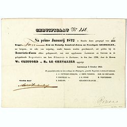
Certificaat N° 230
Text reads "Na primo januarij 1872 is houder dezes geregtigd voor 2/2147 tot hetgeen, ter zake van verjariing, zoude kunnen worden gereclmeerd, uiy gelden bij de Ass...
Place & Date: Amsterdam, 1841
Very rare share in the Ostend Company.
Upper left hand corner share number 2305 in manuscript. In top emblem of the Ostend Company in copper engraving. Text: De Directeurs van de generale Keijserlijche- Indisc...
Place & Date: Antwerp / Ostend, 1723

La nuova Zelanda delineate sulle ultima osservazioni del Capitan Cook.
First edition on laid paper Cassini’s splendid early map of New Zealand, being the most decorative version of Captain Cook's map of New Zealand, published in the very s...
Place & Date: Rome, 1798

L'Arabia delineata sulle ultime osservazioni.
First edition on laid paper. Cassini’s splendid early map of Arabia.
Place & Date: Rome, 1797

A Map of the British Empire in AMERICA with the French, Spanish and Hollandish Settlements Adjacent Thereto. by Henry Popple. / Nouvelle Carte Particuliere de L'Amerique . . .
The four sheet Dutch edition of Popple's monumental map of North America, in mint condition. Encompassing the West Indies, Florida, Louisiana, Texas and Central America.T...
Place & Date: Amsterdam, ca. 1737

Carte de la province de Quan-tong, ou Lyau-tong et du Royaume de Kau-li. . .
Map of Korea. The map is of interest for the use of East Sea, the sea between Korea and Japan, here called "Mer de Corée" and "Meer von Korea".From a...
Place & Date: Paris, 1757
Selling price: $450
Sold in 2023
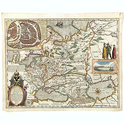
Tabula Russiae.
A re-issue, by Willem Blaeu, of Hessel Gerritsz' rare and influential map of Russia. This fine map was compiled from manuscripts brought back from Russia, by Isaac Massa ...
Place & Date: Amsterdam, 1650

Arabia
A lovely miniature map the Arabian Peninsular, published by Petrus Bertius, and published in Amsterdam at the beginning of the seventeenth century. With an attractive s...
Place & Date: Amsterdam, 1606

Ormus
A lovely map of miniature map the Kingdom of Ormus, published by Petrus Bertius, and published in Amsterdam at the beginning of the seventeenth century. With an attractiv...
Place & Date: Amsterdam, 1606
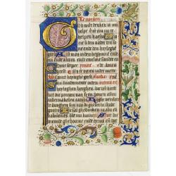
Leaf on vellum, from a manuscript book of hours.
Scatter border of flowers. Borders of very high quality, executed by an artist of the Ghent-Bruges school.VERSO: 19 lines of Dutch text in brown ink. A 6-lines capital &q...
Place & Date: Flanders, 1450

Asia By H.Moll Geographer.
Detailed map of Asia. From his "Atlas minor: or a new and curious set of sixty-two maps. . .", which was first published in 1729 and reprinted in 1732, 1736.The...
Place & Date: London, 1736

Carte des Isles du Japon Sequels est remarque la Route..
This uncommon map of Japan, a reduced version of his larger map, contains comments about the nature of the country. For instance, Ocsaqui (Okazaki, near Nagoya) is said t...
Place & Date: Paris / Amsterdam, 1679

Pascaerte vande Caribische Eylanden, vande Barbados tot aende Bocht van Mexico ‘t Amsterdam By Hendrick Doncker. . .
First state. Rare. “This chart appeared in the first edition of Hendrick Doncker’s Zee-Atlas, of which no surviving example is known” -- Burden. This is an example ...
Place & Date: Amsterdam, 1659

Manoeuvres executées du 7 au 13 mai sous le Commandement du général Koeltz,par le XIXe Corps d'Armée. . .
Poster by Gaston Ry [aka René Rostagny] (1902-1978) showing the allied manouvers in Tunesia. On May 4, 1943, the nineteenth CA offensive drew most of the German tanks to...
Place & Date: Alger, Bacconnier, 1943
![[Magazine including pictorial world map, Carriers of the New Black Plague by William Cotton.]](/uploads/cache/43680-250x250.jpg)
[Magazine including pictorial world map, Carriers of the New Black Plague by William Cotton.]
Front cover with color illustration of Moroccan male sheik and yellow lettering.Oversized magazine, features analysis of English justice, map of Herr Hitler's heaven (ful...
Place & Date: Chicago, April 7th, Vol.1 No.1 1938
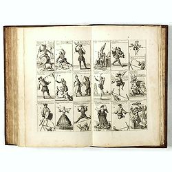
Het Groote Tafereel der Dwaasheid, vertoonende de opkomst, voortgang en ondergang der Actie, Bubbel en Windnegotie, in Vrankryk, Engeland, en de Nederlanden, gespleegt in den Jaare MDCCXX...
AN EARLY ISSUE of this biting and vulgar satire on the Mississippi and South Sea Bubbles and an extraordinary visual record with 78 plates of the first banking crash, sho...
Place & Date: Amsterdam, 1720
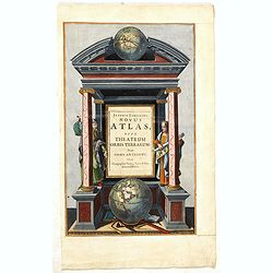
Joannis Janssonii Novus Atlas, sive Theatrum Orbis Terrarum: in quo Orbis Antiquus. . .
A glorious mid-seventeenth century engraved frontispieces to atlas by Janssonius. Finely decorated with a pair of terrestrial (bottom) and celestial (top) globes and the ...
Place & Date: Amsterdam, 1650

Asiae Minoris nova descriptio. Geographische Beschryvinge aller Landen... ende sendbrieuen der Apostele...
Extremely rare map from a Dutch bible, published by Dancker Danckerts. This map was included in a Dutch bible including several maps signed by C.Danckerts and one dated 1...
Place & Date: Amsterdam, 1643

Calendrier de la cour, tiré des éphémérides, pour l'Année bissextile.. / Notebook bearing silver plates with the VOC monogram.
A personal gift, only made for the trustees of the V.O.C. The silver plate was probably made by Drick van Hengel and Company because an entry in the diary of mintmaster J...
Place & Date: Paris, 1787

La Pieuvre Germanique.
Scarce lithographed plate not dated, by Eugène Danzanvilliers, printed by Grandremy in Paris. The plate listed by Adhemar is dated 1874. Eugène Danzanvilliers was a dra...
Place & Date: Paris, 28 Quai de la Rapée, c.1874

FN HJAELP (Help).
Danish poster depicting a child sitting on a globe, threatened by a black snake. Designed by Aage Sikker Hansen and printed Andreasen & Lachmann in Copenhagen, Denmar...
Place & Date: Copenhagen, ca. 1950
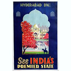
Hyderabad Dn - See Indias, premier state (Taj Mahal).
Beautiful color lithographed travel poster promoting India, more precisely the Taj Mahal.Published by Azam Steam Press Hyd. Dn.active in India.
Place & Date: India, 1930
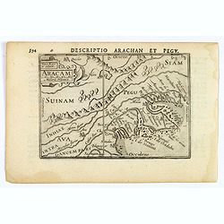
Aracam.
A rare miniature map of Thailand and Burma. Title cartouche on the upper left corner. First published in 1598 in his 'Caert-Thresoor', the plates were executed by the mos...
Place & Date: Amsterdam, 1606
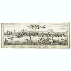
Candie.
A panoramic view, showing the Turkish siege of Candia, with a numbered key (1-33) at the bottom locating 33 points of interest. of Crete coast and the Turkish vessels (33...
Place & Date: Amsterdam, ca. 1678

Carte des pavillons accompagnée d'observations pour en faire comprendre le blazon et les différentes devises aussy bien que d'une table alphabétique pour les trouver facilement.?
Map of 88 marine flags, including Malta, Turkey, Middelburg, Amsterdam, Portugal, Monaco, Tuscany, China, Nanking, the French Royal flag, French admiralty flag and mercha...
Place & Date: Amsterdam, 1720

A Map and Chart of Arabia, the Red Sea, & Persian Gulf, drawn from the Chart of the Eastern Ocean, Publish'd in 1740, by Order of ye Count de Maruepas,...
A small but unusual map of the Arabian Peninsular, engraved by G. Child for 'The universal traveller: or, A compleat description of the several nations of the world', by ...
Place & Date: London, Th. Salmon, 1752-1753

Carte de l'Arabie d'après les différents morceaux qu'a donnés M. Niebuh...
Detailed map of the Arabian peninsular, after Niebuhr, with scales in lower left corner. Engraved by Pierre-Paul Dubuisson.More about Mapping of Arabia [+]
Place & Date: Paris, ca. 1820

Tweevoudigh onderwiis van de Hemelsche en Aerdsche Globen; Het een Na de meyning van Ptolemeus met een vasten Aerdkloot...
Tweevoudigh onderwiis van de Hemelsche en Aerdsche Globen; Het een Na de meyning van Ptolemeus met een vasten Aerdkloot; Het ander Na de Natuerlijcke stelling van N. Cope...
Place & Date: Amsterdam, 1655

Atlas Universel de Géographie. Sixième partie - Océanique.
Volume 6 including detailed maps of Australia, New Zealand, Hawaii, Pacific islands, Indonesia and 3 maps of the Philippines. With title page and one general map.Supporte...
Place & Date: Brussels 1827

Waere affbeeldinge wegens het casteel ende stadt Batavia.
A good impression of this finely engraved and detailed plan of Batavia, present-day Jakarta, the Dutch center of trading activities in the East Indies. Copied after Cleme...
Place & Date: Amsterdam, 1681

Tafel der Lender darin der Apostel Paulus geprediget hat.
Rare wood block map depicting the Mediterranean, with an over-sized Cyprus from the final Dutch edition of Heinrich Bünting's famous Itinerarium Sacrae Scripturae, a boo...
Place & Date: Magdeburg, 1581

Der Hollaendisch-Ostindianischen Compagnie Weltberühmte Haupt - Handels und Niederlags stadt BATAVIA..
Very fine decorative plan of Batavia showing the City and its immediate environs, the surrounding rice fields intersected by a network of waterways, canals and outlying f...
Place & Date: Nuremberg, 1733
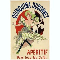
Quinquina Dubonnet, apéritif dans tous les cafés.
Original chromo lithographed medium size poster, "Quinquina Dubonnet, apéritif dans tous les cafés", by CHERET, signed in the plate. Supplement to "Courr...
Place & Date: Paris, Imprimerie Chaix, 1895

Nieuwe en Nette Afteekening van het Eyland Corsica en het Eyland Elba vertoonende alle desselfs Havenen, Steeden en Rivieren . . .
Highly decorative large sea chart of Corsica, Sardinia and Elba, including multiple sailing ships, compass roses, cartouche, coat of arms, rhumb lines, topographical deta...
Place & Date: Amsterdam, ca. 1710

L'Homme A La Boule.
Satirical print in which Count Otto von Bismarck balances on the world with one spurred foot entering France, and wearing only his underpants which are marked with the Ge...
Place & Date: Paris, 1870-1871
![[Title page] Atlante Novissimo, illustrato ed accresciuto . . .](/uploads/cache/43897-250x250.jpg)
[Title page] Atlante Novissimo, illustrato ed accresciuto . . .
Decorative Venitian frontispiece from Antonio Zatta's Atlas Atlante Novissimo, illustrato ed accresciuto . . . . The outer decoration of this title page has a wealth of c...
Place & Date: Venice, 1785
![[Title page] Atlante Novissimo, Tomo I . . .](/uploads/cache/43898-250x250.jpg)
[Title page] Atlante Novissimo, Tomo I . . .
Decorative Venitian frontispiece from Antonio Zatta's "Atlante Novissimo tomo I".
Place & Date: Venice, 1779

Daniae regni typum . . .
Second Edition, now for the first time with a date (1630), this rare map which - like that of Janssonius-Kaerius - is based on John Speed's map of 1626. The side borders ...
Place & Date: Amsterdam, 1630
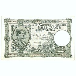
1000 Francs ou 200 Belgas (Belgian bank note)
The National Bank of Belgium issued Belgian Franc banknotes in 10 different denominations, including this 1000 Belgian Francs 200 Belgas banknote (Série Nationale). They...
Place & Date: Belgium, after 1928
![Province de Fo-Kien. [Includes West Coast of Taiwan]](/uploads/cache/43503-250x250.jpg)
Province de Fo-Kien. [Includes West Coast of Taiwan]
Important map of Fujian Province, showing the east coast of China and the west coast of Taiwan. It shows that for the Manchu Qing, only the western half of Formosa was co...
Place & Date: The Hague, H. Scheurleer, 1737
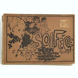
Petit solfège illustré. Illustrations de Pierre Bonnard. Deuxième mille.
30 compositions by Bonnard, mostly printed in colors, integrated with and surrounding the texts and musical passages. Publisher’s dec. boards, with full-cover illustrat...
Place & Date: Paris, 1893

Cunard to Canada.
Poster by Charles Eddowes Turner for Cunard lines. The poster shows The NEW SYLVANIA, one of the four new 22,000 - ton Cunarders which are the largest ever built for serv...
Place & Date: England, ca. 1930

A fan combining views of Hong Kong (right), Canton (center), and Macau.
The fan shows nice images of Macau, Hong Kong and Canton on onside and on verso a garden with 45 characters welcoming a rider on his white horse. Their clothes are height...
Place & Date: China, ca. 1850-1860
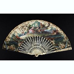
An elegant couple with a caged bird in a landscape.
Folding fan made of skin sheet and mounted in English style, with a painted scene of an elegant couple with a caged bird in a landscape.Painted verso of a man among ancie...
Place & Date: Paris, 1790
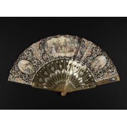
Country pleasures.
Folding fan made of a double sheet of lithographed paper, enhanced with gouache and watercolor, with a decoration of three cartouches with gallant scenes of French countr...
Place & Date: France, ca. 1850-1860
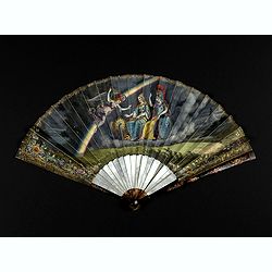
Very fine folding fan with painting of Minerva, Juno and 2 peacocks.
Small folding fan made of double skin sheet, mounted in English style, painted with gouache and depicting Minerva and Juno sitting near each other and receiving the visit...
Place & Date: ca. 1820

Ultrajectum.
An original early 17th century copper engraved miniature antique map of the Dutch province of Utrecht by Petrus Bertius, that was published in Amsterdam at the beginning ...
Place & Date: Amsterdam, 1606

L'Homme A La Boule.
Satirical print in which Count Otto von Bismarck balances on the world with one spurred foot entering France, and wearing only his underpants which are marked with the Ge...
Place & Date: Paris, 1870-1871
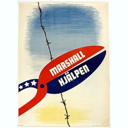
Marshall Hjälpen.
Marshall Plan poster made by Gusta Aberg, showing barbed wire cut by pliers with slogan on pliers: Marshall Hjälpen This is one of the 25 finalists in the 1950 “Intra-...
Place & Date: Kühn & Zoon Rotterdam, 1950

Philippines Islands.
Pictorial map of Philippines Islands, from the famous illustrator, Ruth Taylor White and published in "Our USA: A Gay Geography".Ruth Taylor White was among the...
Place & Date: Boston, Little, Brown and Company, 1935

Nova XVII Provinciarum Inferioris Germaniae descriptio .
Extremely rare map of the Benelux by Frederick de Widt. Originally engraved and published by P.Kaerius in 1607. In 1662 the plate came in the possession of Frederick de W...
Place & Date: Amsterdam, 1662

Mapa geogra´fico de la mayor parte de la Ame´rica Meridional que contiene los paises por donde debe trazarse la li´nia divisoria que divida los dominios de Espan~a y Portugal. . .
Rare first edition of the map drawn by Francisco Requena (1743-1824) after his expedition to the Amazon in order to delineate the boundary between the Spanish and Portugu...
Place & Date: Bourquin, F. Philadelphia, ca. 1876
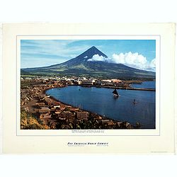
Philippines - The famous volcanic peak Mt. Mayon. . .
Mt Mayon Volcano Peak near Legaspi on the Philippines. Fine Pan American Airline mini poster.Pan American World Airways, originally founded as Pan American Airways and co...
Place & Date: 1956
Selling price: $150
Sold in 2023
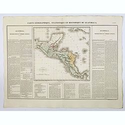
Carte Geographique, Statistique et Historique de Guatimala.
A nice detailed map of Guatemala from Buchon's Atlas Gégraphique Statistique, historique et chronologique des deux Ameriques et des isles adjacentes traduit de l'atlas e...
Place & Date: Paris, 1825

Carte Geographique, Statistique et Historique de l'Amerique Meridionale.
A nice detailed map of South America from Buchon's Atlas Gégraphique Statistique, historique et chronologique des deux Ameriques et des isles adjacentes traduit de l'atl...
Place & Date: Paris, 1825

Carte Geographique, Statistique et Historique du Perou.
A nice detailed map of Peru from Buchon's Atlas Gégraphique Statistique, historique et chronologique des deux Ameriques et des isles adjacentes traduit de l'atlas exécu...
Place & Date: Paris, 1825

Carte Geographique, Statistique et Historique de Buenos-Ayres.
A nice detailed map of what is today northern Argentina (Rep. of Buenos Ayres or the United Provinces of South America) from Buchon's Atlas Gégraphique Statistique, hist...
Place & Date: Paris, 1825
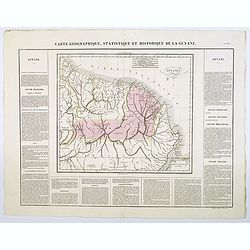
Carte Geographique, Statistique et Historique de la Guyane.
A nice detailed map of Guyana from Buchon's Atlas Gégraphique Statistique, historique et chronologique des deux Ameriques et des isles adjacentes traduit de l'atlas exé...
Place & Date: Paris, 1825
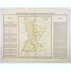
Carte Geographique, Statistique et Historique du Paraguay.
A nice detailed map of Paraguay from Buchon's Atlas Gégraphique Statistique, historique et chronologique des deux Ameriques et des isles adjacentes traduit de l'atlas ex...
Place & Date: Paris, 1825
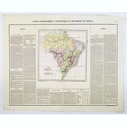
Carte Geographique, Statistique et Historique du Bresil.
A nice detailed map of Brazil from Buchon's Atlas Gégraphique Statistique, historique et chronologique des deux Ameriques et des isles adjacentes traduit de l'atlas exé...
Place & Date: Paris, 1825
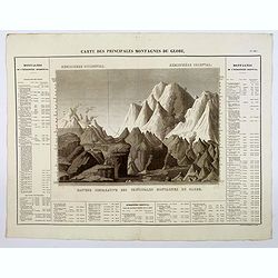
Carte des Principales Montagnes du Globe.
A nice detailed depiction of the principal mountains of the world from Buchon's Atlas Gégraphique Statistique, historique et chronologique des deux Ameriques et des isle...
Place & Date: Paris, 1825
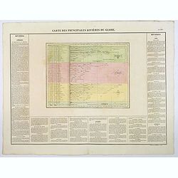
Carte des Principales Riviers du Globe.
A nice detailed depiction of the principal rivers of the world from Buchon's Atlas Gégraphique Statistique, historique et chronologique des deux Ameriques et des isles a...
Place & Date: Paris, 1825
![[TAI travel poster]](/uploads/cache/44304-250x250.jpg)
[TAI travel poster]
A whimsical travel poster for "Transport Aeriens Intercontinentaux" (TAI), published in Paris in 1960, by Luc-Marie Bayle (1914-2000). The poster depicts a twin...
Place & Date: Paris, 1960
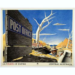
Outposts of Empire. Central Australia.
A large colored lithograph by John Vickery (1906-1983), he was an Australian artist. He worked in the fields of painting, illustration and advertising. He is the only Aus...
Place & Date: London, ca 1937

Outposts of Empire. Ceylon.
A large colored lithograph by John Vickery (1906-1983), he was an Australian artist. He worked in the fields of painting, illustration and advertising. He is the only Aus...
Place & Date: London, ca 1937
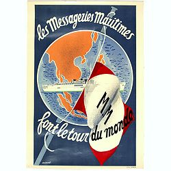
Les Messageries Maritimes font le tour du monde.
Original lithographed mini poster (570 x 400mm.) created by the artist Robert Louis Antral for Les Messageries Maritimes, showing a boat and a globe. Les Messageries Mari...
Place & Date: Paris, 1955
![Le Sacre Hagard [Haggard-falcon]](/uploads/cache/44315-250x250.jpg)
Le Sacre Hagard [Haggard-falcon]
A beautiful elephant folio sized colored lithograph of a Hagard Falcon, taken from the famous book on Falconry Traite de Fauconnerie by Schlegel and A.H. Verster van Wulv...
Place & Date: Leiden, 1844-1853

Circoscrizione delle Provincie ecclesiastiche e Diocesi nei regni del Belgio, ed Olanda (Tav LXI)
This large-format map showing Belgium and Holland with its different dioceses. The map is finely engraved and beautifully colored and was prepared by Girolamo Petri, a la...
Place & Date: Rome, 1858

Provincia ecclesiastica di Malines nel Belgio (Tav LXII)
This large-format map of Belgium with its different dioceses. The map is finely engraved and beautifully colored and was prepared by Girolamo Petri, a lawyer who served a...
Place & Date: Rome, 1858
![[Manuscript chart on vellum of the Java Sea]](/uploads/cache/33613-250x250.jpg)
[Manuscript chart on vellum of the Java Sea]
One of the few manuscript charts on vellum in private hands, signed by Isaac de Graaf. ORIGINAL MANUSCRIPT MAP IN RED, GREEN AND BLACK INK showing the Java Sea centered o...
Place & Date: Amsterdam, 1743

Frisia occidentalis.
A rare separately published carte-a-figures of Friesland by Geelkercken in its first state. The title and the coats of arms of the eleven Frisian towns appear in the cent...
Place & Date: [Leeuwarden], Dierick Albertsen, 1618

Belgii sive Germaniae Inferioris accuratissima tabula.
Very rare and very decorative map with in the right and left borders costumed figures and town plans alternately. In top and bottom border town plans and views.Separate p...
Place & Date: Amsterdam, 1631

Amstelodamum, Celebre Emporium Forma Plana.
Second state of this rare and decorative plan of Amsterdam with Visscher's imprint. With a panoramic view seen from the IJ and further insets of Council House, The Exchan...
Place & Date: Amsterdam, c. 1636

Composite atlas of the Low Countries.
A composite atlas comprising 18 double-page engraved maps by or after Hessel Gerritsz, Theodoor Galle, Jacob van Deventer, Gerard Mercator, Peter Verbiest, Jean Surhon, C...
Place & Date: [Antwerp, c. 1633

Nieuw Nederlandtsch Caertboeck. Waer in volkomentlijcker als oyt te voren vertoont werden de XVII. Nederlanden.
Rare first edition of this atlas of the provinces of the Netherlands, Belgium and Luxemburg. Engraved title page, with : "Gedruckt t' Amsterdam by Abraham Goos Plaet...
Place & Date: Amsterdam, 1616