Browse Listings in America > North America

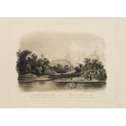
Forest scene on the Tobihanna Alleghany Mountains.
Original aquatint engraving for Travels in the Interior of North America between 1832-34 . Engraved by L.Weber. The finest work on American Indian life and the American F...
Date: London/Paris/Coblenz, 1839
Waschinga Sahba's Grab.. (Wakonda Creek.)
Original aquatint engraving for Travels in the Interior of North America between 1832-34 . Engraved by Ch. Vogel. The finest work on American Indian life and the American...
Date: London/ Paris/ Coblenz, 1839

Upper Canada &c.
A beautiful, large scale map of Upper Canada, and portions of the American states of New York, Ohio, and Pennsylvania. The province of 'Upper' Canada was created by the B...
Date: London, 1839
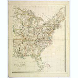
United States.
A lovely large map of the Untied States, as it was at the time of publication. Each state shown in a different outline color. Nothing is shown west of Louisiana, Arkansas...
Date: London, 1839
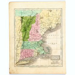
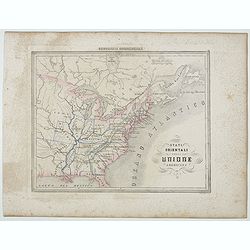
Eastern States.
A map of the eastern US seaboard from Long Island north to Lower Canada, comprising the states of Connecticut, Rhode Island, Massachusetts, New Hampshire, Maine, Vermont ...
Date: Connecticut, 1839

La parte orientale dell' antico.. messico con la Florida..
A splendid two-sheet map of Mexico, including California, Arizona, New Mexico, part of Texas, Baja California and Mexico (west part) and of the Southeast Part of the US, ...
Date: Rome, Calcography, 1797-before 1839

20 small lithographed views of Washington DC and Georgetown.
20 small lithographed town-views of Washington DC and Georgetown, cut out from a larger sheet. Showing the East Front of the Capitol, Treasury, Smithsonian Institute, Pre...
Date: Casimir Bohn, Washington, D.C.: 1849

Map of the Great Salt Lake And Adjacent Country in the Territory Of Utah. Surveyed in 1849 and 1850, under the orders of Col. J.J. Abert ...
Map of the Great Salt Lake And Adjacent Country in the Territory Of Utah. Surveyed in 1849 and 1850, under the orders of Col. J.J. Abert .. by Capt. Howard Stansbury .. a...
Date: Ackerman, New York, 1852
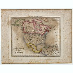
Nuovo Mondo parte Settentrionale.
Uncommon map of North America prepared by Francesco Costantino Marmocchi. Above the map "Geografia Commerciale". From "Il Globo Atlante di carte Geografich...
Date: Genova, Paolo Rivara fu Giacomo, 1858
Stati Orientali della Unione Americana.
Uncommon map of Northeastern America prepared by Francesco Costantino Marmocchi. Above the map "Geografia Commerciale". From "Il Globo Atlante di carte Geo...
Date: Genova, Paolo Rivara fu Giacomo, 1858
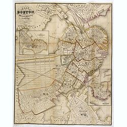
Plan Of Boston Comprising a Part of Charlestown and Cambridge. Published by George G. Smith, Engraver, Washington Street Boston 1855..
Important and detailed plan of Boston, with insets :"Plan Of East Boston from actual Survey by R.H. Eddy" and "Plan Of South Boston From a Drawing by S.P. ...
Date: Boston, ca. 1859

Kiepert's Physikalische Wandkarten. VI. Nord-America.
Large folding school wall map of North and Central America printed in chromo-lithography. Published by Dieter Reimer and printed by Leopold Kraatz in Berlin. Three inset...
Date: Berlin, Dieter Reimer, 1864
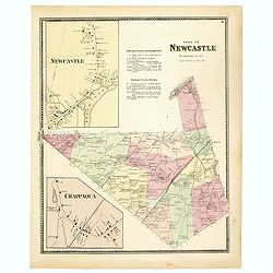
Town of New Castle. Westchester Co. NY.
Fine lithographed map of the town of New Castle. The map provides the names of specific homeowners, as well as information about the occupations and physical locations of...
Date: New York, 1867

Plan of Yonkers Town of Yonkers Westchester Co. N.Y. . . .
Fine lithographed map of Yonkers, New York. The map provides the names of specific homeowners, as well as information about the occupations and physical locations of the ...
Date: New York, 1867

Plan of the Borough of New Rochelle, Westchester Co. N.Y.
Fine lithographed map of the plan of the Borough of New Rochelle. The map provides the names of specific homeowners, as well as information about the occupations and phys...
Date: New York, 1867

Plan of the Beekmanton Tarryntown and Ivring. Westchester Co. N.Y.
Fine lithographed map of the plan of the Beekmantown, Tarrytown, and Irving, New York. The map provides the names of specific homeowners, as well as information about the...
Date: New York, 1867

New York Ferry Boat. (Bac à vapeur de New York).
A very decorative print showing the New York Ferry Boat "Fulton," published by Currier & Ives. The Ferry boat "Fulton" sails to the right. A singl...
Date: New York, ca. 1875

Région arctique.
Decorative map of the North Pole, prepared by Louis Vivien de Saint-Martin (* 22. Mai 1802 in Saint-Martin de Fontenay, died 3 January 1897 in Paris). He was one of the m...
Date: Paris, Hachette, 1877

Dutton Map of the Grand Canyon, Arizona (in 4 joined sheets)
An important 1882 map of the Grand Canyon, Arizona, published in "Atlas To Accompany The Monograph On The Tertiary History Of The Grand Canon District By Capt. Clare...
Date: Julius Bien and Co., 1882

Driving chart of Hartford and vicinity : 15 miles around.
Road map by Albert A. Hyde & Co. of Hartford and vicinity, with the Connecticut River in the center. Published by Albert A. Hyde & Co., in New York and lithograph...
Date: New York / Philadelphia, 1884
![Canada Creek Falls . . [title in French, English, German & Latin] N°32. Pl. 4.](/uploads/cache/26800-250x250.jpg)
Canada Creek Falls . . [title in French, English, German & Latin] N°32. Pl. 4.
A view of the Canada Creek Falls.From 8e Livraison Amérique Septentrionale - Etat de New York. After Jacques Milbert and lithographed by Dupressoir and figures by V. Ada...
Date: Paris, Bove dirigée par Nöel ainé & Cie, 1892
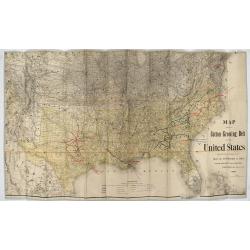
Map showing the cotton growing belt in the United States Prepared for and copyrighted by Geo. H.Mc.Fadden & Bro., cotton merchands based in Phiiladelphia, USA 1892.
The cotton-growing Belts in the Southern States for 1892 A rare map showing the cotton-growing Belts in the Southern States for 1892. Prepared for and copyrighted by G...
Date: Philadelphia, 1892
![[Soil map] Virginia-Maryland-West Virginia, Leesburg sheet.](/uploads/cache/23257-250x250.jpg)
[Soil map] Virginia-Maryland-West Virginia, Leesburg sheet.
Early color lithographed soil map by Julius Bien & Co. in New York for Department of Agriculture. Legends at side give detail on soil type, etc. They also include int...
Date: New York, 1903
![[United States map with Ottoman script.]](/uploads/cache/44314-250x250.jpg)
[United States map with Ottoman script.]
Postcard-size map in Ottoman script showing the United States, prepared by Mehmet EŞREF in a small atlas: عمومولاياةىشهانيىحاوىكوچكاطلاس [...
Date: Istanbul, 1325 or 1909

Guaranty Trust Company of New York. Emprunt national 6%.n Souscrivez.
Very decorative propaganda poster with design by Mark All of Paris for "Guaranty Trust Company of New York", a JPMorgan Chase predecessor in order to promote th...
Date: Paris, 1918

Cunard Cherbourg-New York.
Original vintage Cunard luxury cruise liner travel poster advertising Cunard Europe to all America fastest ocean service in the world. Stunning design featuring two color...
Date: England, ca. 1930

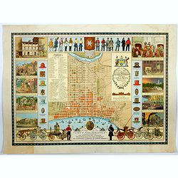
United States At-A-Glance.
A clever device for demonstrating the statistics of each state, the Area, Population, Highest Elevation, Principal River, Capital, railroad Mileage, Date Entered Union, P...
Date: New York / London: International At-A-Glance Chart Co. 1931

A Hysterical Map of the Yellowstone Park. . .
A funny 1936 pictorial map of Yellowstone Park, that was 'hatched and scratched' by the American printer and humourist Jolly Elmer Lindgren. This wonderful map covers the...
Date: Spokane, 1936

French Line CGT Poster.
French Line CGT Poster showing the Normandie cruise ship travelling from Southampton to New York, advertising an express luxury service on both the Ile de France and the ...
Date: England, ca. 1936
A Map of the City of Philadelphia, showing the Location of the Volunteer Fire Companies. . .
A fine, large pictorial plan of the City of Philadelphia, based on the drawing by Jacob Riegel in 1937, which itself was based on an earlier work dating back to 1794. The...
Date: Philadelphia, 1938

The Greyhound Map of This Amazing America. . .
A large colored lithograph map of the USA, published by the Greyhound Corporation during the Second World War. The map demonstrates where all the Greyhound bus routes int...
Date: United States, 1941
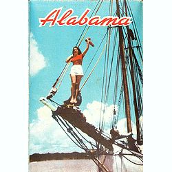
Alabama. Official Highway map 1942.
Folding road map of Alabama. Published in Montgomery, Alabama by Paragon Press. Mileage chart and six city plans in margin; verso includes text and photos. Scale [ca. 1:8...
Date: Alabama, Paragon Press, 1942
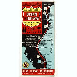
New York - Miami Ocean Highway. Pines to Palms. - Ocean Highway Official Highway Route Approved and Sponsored by the Ocean Highway Association.
Vintage road map showing "The Route of the Experience Motorist" features mileage information in the right margin. Verso features information on cities along the...
Date: Washington, ca. 1947

A Hysterical Map Of Death Valley National Monument -- And It's Looking Mighty Low
First edition Humorous map of Death Valley. "Drawn In Broken English by Jolly Lindgren," this comic pictorial map is full of puns and comic vignettes related to...
Date: Spokane, Wash., Lindgren Brothers, 1948

Coast to Coast.
A game board that features a map of the U.S. with a built-in spinner. Players travel a circular track around the map visiting landmarks as they go. A fun way to learn geo...
Date: New York, ca. 1950
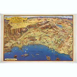
Ride the Roads to Romance along the Golden Coast and thru the Sunshine Empire of Southern California.
Published in 1950 by the Roads to Romance Association to promote tourism in California This striking touring map of Southern California was published in 1950 by the Ro...
Date: California, 1950

Sabena (USA - NYC).
Sabena Belgian World Airlines poster showing the skyline of New York in abstract style. Published by Rali Brisart in Belgium.La Sabena, acronym for Societé Anonyme Belg...
Date: Brussels, ca. 1970
