Sign In or Sign Up
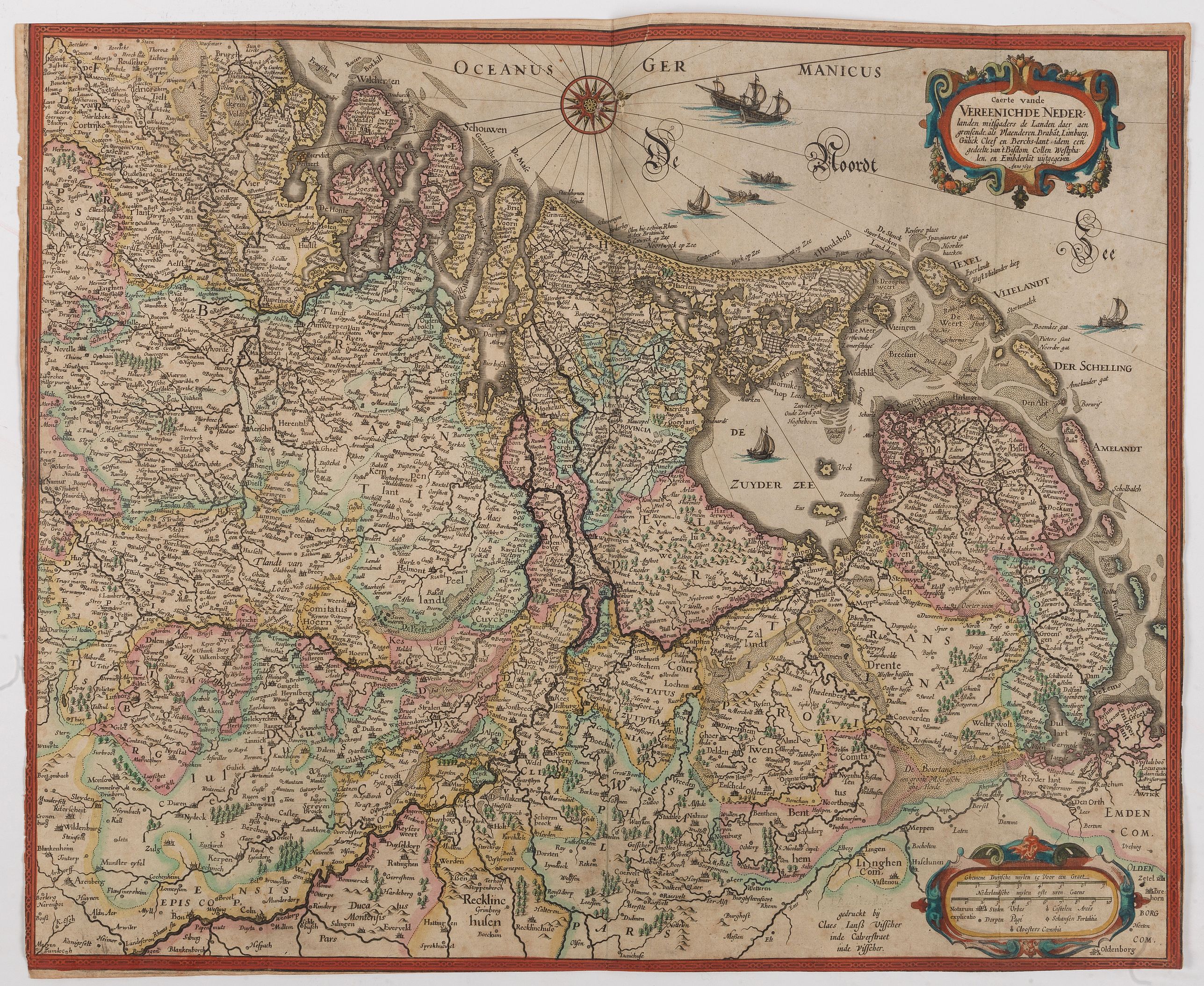
1630 VISSCHER, Claes Janszoon. - One of the earliest maps of the Dutch Republic.
Caerte vande Vereennichde Nederlanden…
| Maker: | VISSCHER, Claes Janszoon. | |
| Date: | Amsterdam, 1630 | |
| Colored: | In attractive original colors. | |
| Size: | 443 x 545 mm / 17.4 x 21.5 inches | |
| Condition: | Verso Blank. Original coloured. Slightly age-toned as usual. Some foxing. Center fold and two additional vertical folds as issued. | |
Add this or any of your favorite items in one place.
If you want to save the items permanently, you have to sign in
or create an account first.

 Add/Remove


Description
The earliest maps of the Dutch Republic. Only two maps of the VII Provinces are known from before 1648, the decisive year of their independence.
The first was a small map by Petrus Kaerius of 1615.
The second map of the northern Netherlands is the map of Claes Jansz Visscher, probably from 1620 or shortly before. "Besides being a gifted engraver, Visscher also excelled as a shrewd businessman who knew exactly how to profit from topical events. This appears from his 'Nieuwskaarten' (news-maps), single sheets with a map and an explanatory text, sold as a precursor to our modern newspaper. In 1623 Visscher purchased the copperplates of the then most beautiful atlas of the Netherlands, Germania Inferior by Kaerius (1617), which he re-edited in 1634, inserting a number of these topical maps: the siege of Breda, of 's-Hertogenbosch and of Bergen op Zoom. After the map of the XVII Provinces and again a map of the XVII Provinces in the shape of the famous Leo Belgicus passant facing left".
SECOND COPY KNOWN OF THE THIRD STATE.
This is the third state showing in very small print the year 1630, with the spelling 'Embderlãt'. The copy described by Vander Heijden is inserted in the curiously 'experimental' atlas of Henricus Hondius, Atlantis Maioris Appendix, 1631, preserved at Freiburg in Breisgau as the only copy known.
The fact that, to the end of showing in his experimental atlas-edition also the liberated United Netherlands, Henricus Hondius as late as-in 1631 had recourse to a map of Claes Jansz Visscher, is significant of the then scanty existence of maps of only the northern Netherlands. In the same year, however, he engraved and published a beautiful map of the XVII Provinces, which he obviously trusted to be a profitable investment.
The "Caerte vande Vereennichde Nederlanden" (1630) is an iconic masterpiece by the prominent Amsterdam cartographer, engraver, and publisher Claes Jansz. Visscher. This historic map captures a pivotal moment in both cartographic art and the political identity of the Dutch Republic during the Eighty Years' War.
Reference: Koeman, III Vis 1A (20)Van der Heijden, 9.2. The earliest maps of the Dutch Republic, Third state.
FAQ - Guarantee - Shipping
This item is available for immediate purchase when a "Add to Cart" or "Inquire Now" button is shown.
Items are sold in the EU margin scheme
Payments are accepted in Euros or US Dollars.
Authenticity Guarantee
 We provide professional descriptions, condition report (based on 45 years experience in the map business)
Paulus Swaen warrants the authenticity of our items and a certificate of authenticity is provided for each acquired lot.
Condition and Coloring
We indicate the condition of each item and use our unnique HiBCoR grading system in which four key items determine a map's value: Historical Importance, Beauty, Condition/Coloring and Rarity.
Color Key
We offer many maps in their original black and white condition. We do not systematically color-up maps to make them more sellable to the general public or buyer.
Copper engraved or wood block maps are always hand colored. Maps were initially colored for aesthetic reasons and to improve readability. Nowadays, it is becoming a challenge to find maps in their original colors and are therefor more valuable.
We use the following color keys in our catalog:
Original colors; mean that the colors have been applied around the time the map was issued.
Original o/l colors; means the map has only the borders colored at the time of publication.
Colored; If the colors are applied recently or at the end of the 20th century.
Read more about coloring of maps [+]
Shipping fee
A flat shipping fee of $ 30 is added to each shipment by DHL within Europe and North America. This covers : International Priority shipping, Packing and Insurance (up to the invoice amount).
Shipments to Asia are $ 40 and rest of the world $50
We charge only one shipping fee when you have been successful on multiple items or when you want to combine gallery and auction purchases.
Read more about invoicing and shipping
FAQ
Please have a look for more information about buying in the BuyNow gallery
Many answers are likely to find in the general help section.
My Collection+

With My Collection+ you can collect all your favorite items in one place. It is free, and anyone can create his or her virtual collection.
Unless you are logged in, the item is only saved for this session. You have to be registed and logged-in if you want to save this item permanently to My Collection+. Read More[+]
Register here, it is free and you do not need a credit card.
Add this item to My Collection+ or click the following link to see My Collection+.
|
Digital Image Download Paulus Swaen maintains an archive of most of our high-resolution rare maps, prints, posters and medieval manuscript scans. We make them freely available for download and study. Read more about free image download |
Click the image for a free small image download. |
YOUR RIGHT TO CANCEL THE PURCHASE OF A LOT
In accordance with the EU Consumer Rights Directive and habitually reside in the European Union you have the right to cancel the contract for the purchase of a lot, without giving any reason.
The cancellation period will expire 14 calendar days from the day after the date on which you or a third party (other than the carrier and indicated by you) acquires, physical possession of the lot. To exercise the right to cancel you must inform Paulus Swaen Inc, of your decision to cancel this contract by a clear statement (e.g. a letter sent by post, or e-mail.
To meet the cancellation deadline, it is sufficient for you to send your communication concerning your exercise of the right to cancel before the cancellation period has expired.
Recently Viewed
Caerte vande Vereennichde Nederlanden…
1630 VISSCHER, Claes Janszoon. - One of the earliest maps of the Dutch Republic.
Date: Amsterdam, 1630
