Sign In or Sign Up
Sign In or Sign Up
Subscribe to be notified if similar examples become available.
1743 ROBERT DE VAUGONDY, G. / SANSON, N. - Atlas général. [Composite atlas].
![Atlas général. [Composite atlas].](/uploads/cache/49062ZA-(1)-800x800.jpg)
![Atlas général. [Composite atlas].](/uploads/cache/49062ZEJ-(1)-800x800.jpg)
![Atlas général. [Composite atlas].](/uploads/cache/49062ZEK-(1)-800x800.jpg)
![Atlas général. [Composite atlas].](/uploads/cache/49062ZEI-(1)-800x800.jpg)
![Atlas général. [Composite atlas].](/uploads/cache/49062ZEL-(1)-800x800.jpg)
![Atlas général. [Composite atlas].](/uploads/cache/49062ZF-(1)-800x800.jpg)
![Atlas général. [Composite atlas].](/uploads/cache/49062ZJ-(1)-800x800.jpg)
![Atlas général. [Composite atlas].](/uploads/cache/49062ZL-(1)-800x800.jpg)
![Atlas général. [Composite atlas].](/uploads/cache/49062ZR-(1)-800x800.jpg)
![Atlas général. [Composite atlas].](/uploads/cache/49062A-250x250.jpg)
![Atlas général. [Composite atlas].](/uploads/cache/49062B-250x250.jpg)
![Atlas général. [Composite atlas].](/uploads/cache/49062D-250x250.jpg)
![Atlas général. [Composite atlas].](/uploads/cache/49062C-250x250.jpg)
![Atlas général. [Composite atlas].](/uploads/cache/49062E-250x250.jpg)
![Atlas général. [Composite atlas].](/uploads/cache/49062G-250x250.jpg)
![Atlas général. [Composite atlas].](/uploads/cache/49062H-250x250.jpg)
![Atlas général. [Composite atlas].](/uploads/cache/49062J-250x250.jpg)
![Atlas général. [Composite atlas].](/uploads/cache/49062F-250x250.jpg)
![Atlas général. [Composite atlas].](/uploads/cache/49062I-250x250.jpg)
![Atlas général. [Composite atlas].](/uploads/cache/49062K-250x250.jpg)
![Atlas général. [Composite atlas].](/uploads/cache/49062L-250x250.jpg)
![Atlas général. [Composite atlas].](/uploads/cache/49062N-250x250.jpg)
![Atlas général. [Composite atlas].](/uploads/cache/49062O-250x250.jpg)
![Atlas général. [Composite atlas].](/uploads/cache/49062P-250x250.jpg)
![Atlas général. [Composite atlas].](/uploads/cache/49062M-250x250.jpg)
![Atlas général. [Composite atlas].](/uploads/cache/49062Q-250x250.jpg)
![Atlas général. [Composite atlas].](/uploads/cache/49062R-250x250.jpg)
![Atlas général. [Composite atlas].](/uploads/cache/49062W-250x250.jpg)
![Atlas général. [Composite atlas].](/uploads/cache/49062Z-250x250.jpg)
![Atlas général. [Composite atlas].](/uploads/cache/49062S-250x250.jpg)
![Atlas général. [Composite atlas].](/uploads/cache/49062T-250x250.jpg)
![Atlas général. [Composite atlas].](/uploads/cache/49062ZB-250x250.jpg)
![Atlas général. [Composite atlas].](/uploads/cache/49062ZBA-250x250.jpg)
![Atlas général. [Composite atlas].](/uploads/cache/49062ZBD-250x250.jpg)
![Atlas général. [Composite atlas].](/uploads/cache/49062ZA-250x250.jpg)
![Atlas général. [Composite atlas].](/uploads/cache/49062ZBC-250x250.jpg)
![Atlas général. [Composite atlas].](/uploads/cache/49062ZBB-250x250.jpg)
![Atlas général. [Composite atlas].](/uploads/cache/49062ZA-(1)-250x250.jpg)
![Atlas général. [Composite atlas].](/uploads/cache/49062ZBE-250x250.jpg)
![Atlas général. [Composite atlas].](/uploads/cache/49062ZBG-250x250.jpg)
![Atlas général. [Composite atlas].](/uploads/cache/49062ZBF-250x250.jpg)
![Atlas général. [Composite atlas].](/uploads/cache/49062ZBI-250x250.jpg)
![Atlas général. [Composite atlas].](/uploads/cache/49062ZBH-250x250.jpg)
![Atlas général. [Composite atlas].](/uploads/cache/49062ZBJ-250x250.jpg)
![Atlas général. [Composite atlas].](/uploads/cache/49062ZBK-250x250.jpg)
![Atlas général. [Composite atlas].](/uploads/cache/49062ZBL-250x250.jpg)
![Atlas général. [Composite atlas].](/uploads/cache/49062ZC-250x250.jpg)
![Atlas général. [Composite atlas].](/uploads/cache/49062ZD-250x250.jpg)
![Atlas général. [Composite atlas].](/uploads/cache/49062ZE-250x250.jpg)
![Atlas général. [Composite atlas].](/uploads/cache/49062ZEA-250x250.jpg)
![Atlas général. [Composite atlas].](/uploads/cache/49062ZEB-250x250.jpg)
![Atlas général. [Composite atlas].](/uploads/cache/49062ZEE-250x250.jpg)
![Atlas général. [Composite atlas].](/uploads/cache/49062ZED-250x250.jpg)
![Atlas général. [Composite atlas].](/uploads/cache/49062ZEC-250x250.jpg)
![Atlas général. [Composite atlas].](/uploads/cache/49062ZEF-250x250.jpg)
![Atlas général. [Composite atlas].](/uploads/cache/49062ZEG-250x250.jpg)
![Atlas général. [Composite atlas].](/uploads/cache/49062ZEH-250x250.jpg)
![Atlas général. [Composite atlas].](/uploads/cache/49062ZEJ-250x250.jpg)
![Atlas général. [Composite atlas].](/uploads/cache/49062ZEK-250x250.jpg)
![Atlas général. [Composite atlas].](/uploads/cache/49062ZEI-250x250.jpg)
![Atlas général. [Composite atlas].](/uploads/cache/49062ZF-250x250.jpg)
![Atlas général. [Composite atlas].](/uploads/cache/49062ZEL-250x250.jpg)
![Atlas général. [Composite atlas].](/uploads/cache/49062ZEJ-(1)-250x250.jpg)
![Atlas général. [Composite atlas].](/uploads/cache/49062ZEK-(1)-250x250.jpg)
![Atlas général. [Composite atlas].](/uploads/cache/49062ZEI-(1)-250x250.jpg)
![Atlas général. [Composite atlas].](/uploads/cache/49062ZEL-(1)-250x250.jpg)
![Atlas général. [Composite atlas].](/uploads/cache/49062ZF-(1)-250x250.jpg)
![Atlas général. [Composite atlas].](/uploads/cache/49062ZH-250x250.jpg)
![Atlas général. [Composite atlas].](/uploads/cache/49062ZL-250x250.jpg)
![Atlas général. [Composite atlas].](/uploads/cache/49062ZG-250x250.jpg)
![Atlas général. [Composite atlas].](/uploads/cache/49062ZJ-250x250.jpg)
![Atlas général. [Composite atlas].](/uploads/cache/49062ZI-250x250.jpg)
![Atlas général. [Composite atlas].](/uploads/cache/49062ZJ-(1)-250x250.jpg)
![Atlas général. [Composite atlas].](/uploads/cache/49062ZL-(1)-250x250.jpg)
![Atlas général. [Composite atlas].](/uploads/cache/49062ZK-250x250.jpg)
![Atlas général. [Composite atlas].](/uploads/cache/49062ZM-250x250.jpg)
![Atlas général. [Composite atlas].](/uploads/cache/49062ZN-250x250.jpg)
![Atlas général. [Composite atlas].](/uploads/cache/49062ZO-250x250.jpg)
![Atlas général. [Composite atlas].](/uploads/cache/49062ZR-250x250.jpg)
![Atlas général. [Composite atlas].](/uploads/cache/49062ZP-250x250.jpg)
![Atlas général. [Composite atlas].](/uploads/cache/49062ZQ-250x250.jpg)
![Atlas général. [Composite atlas].](/uploads/cache/49062ZR-(1)-250x250.jpg)
![Atlas général. [Composite atlas].](/uploads/cache/49062ZS-250x250.jpg)
![Atlas général. [Composite atlas].](/uploads/cache/49062ZT-250x250.jpg)
![Atlas général. [Composite atlas].](/uploads/cache/49062ZU-250x250.jpg)
![Atlas général. [Composite atlas].](/uploads/cache/49062ZV-250x250.jpg)
![Atlas général. [Composite atlas].](/uploads/cache/49062ZX-250x250.jpg)
![Atlas général. [Composite atlas].](/uploads/cache/49062ZW-250x250.jpg)
![Atlas général. [Composite atlas].](/uploads/cache/49062ZY-250x250.jpg)
![Atlas général. [Composite atlas].](/uploads/cache/49062ZZ-250x250.jpg)
Atlas général. [Composite atlas]. |
||||||||||||||||||||
|
||||||||||||||||||||
|
|
||||||||||||||||||||
|
|
My Collection +
Add this or any of your favorite items in one place. If you want to save the items permanently, you have to sign in or create an account first.   Add/Remove
 |
|||||||||||||||||||



Description
ROBERT DE VAUGONDY, Gilles / SANSON, N. / JAILLOT, H. / BAILLIEU(L), Gaspard; ATLAS CONSISTING OF MOST OF THE EARLIEST PUBLISHED MAPS BY GILLES ROBERT DE VAUGONDY, 1720-1743.
The Atlas is illustrated with 71 maps, most of them after the Sanson family and early corrected by Gilles Robert de Vaugondy with his imprint. Four maps are by H. Jaillot, two by N. De Fer, and ten by G. Baillieul.
The first two pages feature a handwritten list of maps « Etat des Cartes Géographiques contenues dans ce Recüeil », the title « Atlas général » and the owner’s name "G Graillet Sansdoz ".
Two leaves in manuscript (list of maps and title) and 71 maps in original outline colors printed on strong paper with wide margins. Maps numbered in brown ink 1-71. A few water stains affect some maps at the outer edge: three brown spots on the first manuscript page and very few brown spots.
Provenance : G. Graillet Sansdoz.
Reference : Pedley 4, 17 ; Catherine Hofmann, Le monde selon Robert de Vaugondy, d’Anville et Beaurain
A made-to-order atlas mostly composed of maps after the Sanson family was early printed by Gilles Robert de Vaugondy can be considered an attempt at a large-scale universal atlas before the publication of the « Atlas Universel » in 1757. The maps are dated between 1704 and 1743. The atlas starts with the rare, first large-format world map by Gilles Robert de Vaugondy, "Mappemonde ou Description du Globe Terrestre ou l'on trouve en general le rapport que toutes les Parties avec les Cieux et entre' elles . . . 1743. ", which supports the theory of a large-scale pre-atlas by G. Robert de Vaugondy.It also comprises four maps of the continents and one map of the two Poles.
The Robert de Vaugondys were descended from the Nicolas Sanson family through Sanson's grandson, Pierre Moullart-Sanson. They inherited much of Sanson's cartographic material from him, which they combined with maps and plates acquired after Hubert Jaillot's death in 1712 to form the basis of the Atlas Universel. (Sources from the Dépôt de la Marine) ".
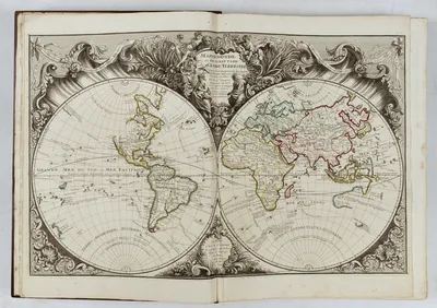 World Map :
This double hemisphere map of the world from the Robert de Vaugondy family workshop is very rare [not in the Bibliotheque National de France ; We locate examples at the Library of Congress and Clemens Library]. The map showcased the state of global knowledge and stood as an anticipatory piece on the cusp of the age of Pacific exploration. The map includes: Search for the Northwest Passage - Terre de la Compagnie - Terre d'Yesso - Australia, includes a fascinating speculative outline shape - New Zealand: only a single, fragmented coast of New Zealand is depicted – Antarctica labeled « Terres Antarctiques Australes …Inconnues ». The map shows the routes of numerous important explorers : - Vasco da Gama and the Cape of Good Hope (1487 (but 1497)) - Ferdinand Magellan's Circumnavigation (1519-1522) - Abel Tasman’s (1642) explorations - Jacob Le Maire and Willem Schouten circumnavigation (1615-1617) etc.
World Map :
This double hemisphere map of the world from the Robert de Vaugondy family workshop is very rare [not in the Bibliotheque National de France ; We locate examples at the Library of Congress and Clemens Library]. The map showcased the state of global knowledge and stood as an anticipatory piece on the cusp of the age of Pacific exploration. The map includes: Search for the Northwest Passage - Terre de la Compagnie - Terre d'Yesso - Australia, includes a fascinating speculative outline shape - New Zealand: only a single, fragmented coast of New Zealand is depicted – Antarctica labeled « Terres Antarctiques Australes …Inconnues ». The map shows the routes of numerous important explorers : - Vasco da Gama and the Cape of Good Hope (1487 (but 1497)) - Ferdinand Magellan's Circumnavigation (1519-1522) - Abel Tasman’s (1642) explorations - Jacob Le Maire and Willem Schouten circumnavigation (1615-1617) etc.
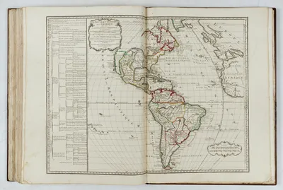 Map of America « Le Nouveau Continent ou l’Amerique, 1740 » (Pedley 17) :
One of the first maps published by Robert De Vaugondy. The map, made with the Mercator projection, is accompanied by a legend which lists important political and sociological facts on the map.
Map of America « Le Nouveau Continent ou l’Amerique, 1740 » (Pedley 17) :
One of the first maps published by Robert De Vaugondy. The map, made with the Mercator projection, is accompanied by a legend which lists important political and sociological facts on the map.
List of maps (the title and date are shown): 1 Mappemonde ou Description du Globe Terrestre, 1743 2 L’Asie Représentée…, 1739 (not by Pedley) 3 L’Afrique Divisée…, 1741 (not by Pedley) 4 L’Europe, Sanson … par le Sr. Robert, 1738 (Pedley 28 – rare) 5 Les Iles Britanniques, 1741 6 L’Angleterre, Sanson … ches le Sr. Robert… n.d. 7 L’Ecosse, 1741
8 L’Irlande, 1741 9 Le Dannemarc, 1741
10 La Norwege, n.d. 11 La Suede, 1741 12 La Russie Blanche ou Moscovie, Jaillot, 1717 13 La France, 1742 14 La Picardie, Sanson … ches le Sr. Robert, 1724 15 La Normandie, n.d. 16 L’Isle de France, Sanson … ches le Sr. Robert, 1722 17 Plan de Paris, par F. Baillieux le Fils… 1736 18 La Champagne, par De Fer… 1710 19 La Bretagne, Sanson… ches le Sr. Robert… 1730 20 L’Orleannais, Sanson… ches le Sr. Robert… 1720 21 Le Duché et le Comté de Bourgogne, Sanson… ches le Sr. Robert… 1730 22 Le Lyonnois, Sanson… ches le Sr. Robert… 1726 23 La Guyenne et la Gascogne, Sanson… ches le Sr. Robert… 1724 24 Le Languedoc, Sanson… ches le Sr. Robert… 1721 25 Le Dauphiné, Sanson… ches le Sr. Robert… 1732 26 La Provence, Sanson… à Paris chez l’Autheur Aux Galleries du Louvre… 1707 27 La Lorraine, Sanson… ches le Sr. Robert… 1740 28 Partie du Cours de la Saare, Par Gaspard Baillieu(l)… 1708 29 Partie du Cours de la Moselle, Par Gaspard Baillieu(l)… 1708 30 L’Alsace, Sanson… ches le Sr. Robert… 1741 31 Partie de la haute Alsace, Par Gaspard Baillieu(l)… 1708 32 Partie du Cours du Rhin, où se trouvent les villes de Strasbourg…, Par Gaspard Baillieu(l) 33 Partie du Cours du Rhin, où se trouvent les villes de Spire… Par Gaspard Baillieu(l) 34 Partie du Palatinat du Rhin, Par Gaspard Baillieu(l)… 1708 35 L’Empire d’Allemagne, Jaillot… 1713 36 Etats situés sur le Rhin et le Necre, Par le Sr. Henri Sengre… chez le Sieur Baillieu(l) 37 Etats situés près du Rhin et du Mein, Par le Sr. Henri Sengre… chez le Sieur Baillieu(l) 38 Partie du Duché du Luxembourg, Par le Sieur Baillieu(l) 39 Partie de l’Electorat de Treves, Par le Sieur Baillieu(l) 40 Les Provinces Unies des Pays Bas, Sanson… ches le Sr. Robert… 1730 41 La Flandre ou Païs-Bas Catholiques, Sanson… ches le Sr. Robert… 1720 42 Cercle de Bavière, Jaillot … 1704 43 Cercle de Franconie, Sanson… ches le Sr. Robert… 1730 44 Cercle de Westphalie, Sanson… ches le Sr. Robert… 1729 45 Les Suisses, les Alliés des Suisses, Sanson…1731
46 Royaume de Hongrie, Jaillot… 1717 47 La Hongrie, la Transilvanie, la Valachie, la Moldavie, … DE Fer/Benard… 1737 48 Le Royaume de Bohême et la Silesie, Jaillot… 1704
49 L’Archiduché d’Autriche, Sanson… ches le Sr. Robert… 1720 50 Duchés de Stirie, Carinthie, Carniole &, Sanson… ches le Sr. Robert… 1742 51 Haute Saxe, Sanson… ches le Sr. Robert… 1730 52 Haute Partie de la Basse Saxe, Sanson… ches le Sr. Robert… 1735 53 Basse Partie de la Basse Saxe, Sanson… ches le Sr. Robert… 1730 54 Royaume de Pologne &, Sanson… ches le Sr. Robert… 1737 55 Electorat de Brandebourg, Sanson… ches le Sr. Robert… 1704 56 Royaume de Prusse, Sanson… ches le Sr. Robert… 1731 57 Les Royaumes d’Espagne, Sanson (imprit partly erased)
58 Le Portugal, Sanson… ches le Sr. Robert… 1740 59 L’Italie, Sanson… ches le Sr. Robert… 1743 60 Haute Lombardie, Sanson… ches le Sr. Robert… 1730 (22 cm tear into the map restored)61 Basse Lombardie, Sanson… ches le Sr. Robert (n.d.) 62 Le Piemont &, Sanson… ches le Sr. Robert… 1741 63 Partie Septentrionale des Etats de Savoye, Sanson… ches le Sr. Robert… 1741 64 Partie Meridionale des Etats de Savoye, Sanson… ches le Sr. Robert… 1741 65 Royaume de Naples, Sanson… ches le Sr. Robert… 1740 66 Calabre, Sanson… ches le Sr. Robert… 1741 67 Royaume de Sicile, Sanson… ches le Sr. Robert… 1735 68 Isle de Corse, Sanson… ches le Sr. Robert… 1731 69 Etats de l’Empire du Grand Seigneur, Sanson… 16. 70 Le nouveau Continent, ou l’Amerique, Sanson… ches le Sr. Robert… 1740 71 Les Pôles Arctique et Antarctique, Sanson, A Paris Aux Galleries du Louvre (n.d.)
Gilles Robert de Vaugondy (1688–1766), also known as Le Sieur or Monsieur Robert, and his son, Didier Robert de Vaugondy (c.1723–1786), were leading cartographers in France during the 18th century.
In 1757, Gilles and Didier Robert De Vaugondy published The Atlas Universel, one of the most important atlases of the 18th century. The Vaugondys integrated older sources with modern surveyed maps to produce the atlas. They verified and corrected the latitude and longitude of many regional maps in the atlas with astronomical observations.
The older material was revised with the addition of many new place names. In 1760, Didier Robert de Vaugondy was appointed geographer to Louis XV.
Gilles and Didier Robert De Vaugondy produced maps and terrestrial globes, working together as father and son. Globes of various sizes were made by gluing copperplate-printed gores on a plaster-finished papier-mache core, a complicated and expensive manufacturing process that employs several specialists. In some cases, it is uncertain whether Gilles or Didier made a given map. Gilles often signed maps as "M.Robert", while Didier commonly signed his maps as "Robert de Vaugondy", or added "fils" or "filio" after his name.
The Robert de Vaugondys were descended from the Nicolas Sanson family through Sanson's grandson, Pierre Moulard-Sanson. They inherited much of Sanson's cartographic material from him, which they combined with maps and plates acquired after Hubert Jaillot's death in 1712 to form the basis of the Atlas Universel. Sources from the Dépôt de la Marine, the official French repository for maritime-related information, were used for their maps of Canada and South America ».
FAQ - Guarantee - Shipping
This item is available for immediate purchase when a "Add to Cart" or "Inquire Now" button is shown.
Items are sold in the EU margin scheme
Payments are accepted in Euros or US Dollars.
Authenticity Guarantee
 We provide professional descriptions, condition report (based on 45 years experience in the map business)
Paulus Swaen warrants the authenticity of our items and a certificate of authenticity is provided for each acquired lot.
Condition and Coloring
We indicate the condition of each item and use our unnique HiBCoR grading system in which four key items determine a map's value: Historical Importance, Beauty, Condition/Coloring and Rarity.
Color Key
We offer many maps in their original black and white condition. We do not systematically color-up maps to make them more sellable to the general public or buyer.
Copper engraved or wood block maps are always hand colored. Maps were initially colored for aesthetic reasons and to improve readability. Nowadays, it is becoming a challenge to find maps in their original colors and are therefor more valuable.
We use the following color keys in our catalog:
Original colors; mean that the colors have been applied around the time the map was issued.
Original o/l colors; means the map has only the borders colored at the time of publication.
Colored; If the colors are applied recently or at the end of the 20th century.
Read more about coloring of maps [+]
Shipping fee
A flat shipping fee of $ 30 is added to each shipment by DHL within Europe and North America. This covers : International Priority shipping, Packing and Insurance (up to the invoice amount).
Shipments to Asia are $ 40 and rest of the world $50
We charge only one shipping fee when you have been successful on multiple items or when you want to combine gallery and auction purchases.
Read more about invoicing and shipping
FAQ
Please have a look for more information about buying in the BuyNow gallery
Many answers are likely to find in the general help section.
My Collection+

With My Collection+ you can collect all your favorite items in one place. It is free, and anyone can create his or her virtual collection.
Unless you are logged in, the item is only saved for this session. You have to be registed and logged-in if you want to save this item permanently to My Collection+. Read More[+]
Register here, it is free and you do not need a credit card.
Add this item to My Collection+ or click the following link to see My Collection+.
|
Digital Image Download Paulus Swaen maintains an archive of most of our high-resolution rare maps, prints, posters and medieval manuscript scans. We make them freely available for download and study. Read more about free image download |
Click the image for a free small image download. |
![Rare, antique map of Atlas général. [Composite atlas].](/uploads/49062.jpg)
![Rare, antique map of Atlas général. [Composite atlas].](/uploads/49062A.jpg)
![Rare, antique map of Atlas général. [Composite atlas].](/uploads/49062B.jpg)
![Rare, antique map of Atlas général. [Composite atlas].](/uploads/49062D.jpg)
![Rare, antique map of Atlas général. [Composite atlas].](/uploads/49062C.jpg)
![Rare, antique map of Atlas général. [Composite atlas].](/uploads/49062E.jpg)
![Rare, antique map of Atlas général. [Composite atlas].](/uploads/49062G.jpg)
![Rare, antique map of Atlas général. [Composite atlas].](/uploads/49062H.jpg)
![Rare, antique map of Atlas général. [Composite atlas].](/uploads/49062J.jpg)
![Rare, antique map of Atlas général. [Composite atlas].](/uploads/49062F.jpg)
![Rare, antique map of Atlas général. [Composite atlas].](/uploads/49062I.jpg)
![Rare, antique map of Atlas général. [Composite atlas].](/uploads/49062K.jpg)
![Rare, antique map of Atlas général. [Composite atlas].](/uploads/49062L.jpg)
![Rare, antique map of Atlas général. [Composite atlas].](/uploads/49062N.jpg)
![Rare, antique map of Atlas général. [Composite atlas].](/uploads/49062O.jpg)
![Rare, antique map of Atlas général. [Composite atlas].](/uploads/49062P.jpg)
![Rare, antique map of Atlas général. [Composite atlas].](/uploads/49062M.jpg)
![Rare, antique map of Atlas général. [Composite atlas].](/uploads/49062Q.jpg)
![Rare, antique map of Atlas général. [Composite atlas].](/uploads/49062R.jpg)
![Rare, antique map of Atlas général. [Composite atlas].](/uploads/49062W.jpg)
![Rare, antique map of Atlas général. [Composite atlas].](/uploads/49062Z.jpg)
![Rare, antique map of Atlas général. [Composite atlas].](/uploads/49062S.jpg)
![Rare, antique map of Atlas général. [Composite atlas].](/uploads/49062T.jpg)
![Rare, antique map of Atlas général. [Composite atlas].](/uploads/49062ZB.jpg)
![Rare, antique map of Atlas général. [Composite atlas].](/uploads/49062ZBA.jpg)
![Rare, antique map of Atlas général. [Composite atlas].](/uploads/49062ZBD.jpg)
![Rare, antique map of Atlas général. [Composite atlas].](/uploads/49062ZA.jpg)
![Rare, antique map of Atlas général. [Composite atlas].](/uploads/49062ZBC.jpg)
![Rare, antique map of Atlas général. [Composite atlas].](/uploads/49062ZBB.jpg)
![Rare, antique map of Atlas général. [Composite atlas].](/uploads/49062ZA-(1).jpg)
![Rare, antique map of Atlas général. [Composite atlas].](/uploads/49062ZBE.jpg)
![Rare, antique map of Atlas général. [Composite atlas].](/uploads/49062ZBG.jpg)
![Rare, antique map of Atlas général. [Composite atlas].](/uploads/49062ZBF.jpg)
![Rare, antique map of Atlas général. [Composite atlas].](/uploads/49062ZBI.jpg)
![Rare, antique map of Atlas général. [Composite atlas].](/uploads/49062ZBH.jpg)
![Rare, antique map of Atlas général. [Composite atlas].](/uploads/49062ZBJ.jpg)
![Rare, antique map of Atlas général. [Composite atlas].](/uploads/49062ZBK.jpg)
![Rare, antique map of Atlas général. [Composite atlas].](/uploads/49062ZBL.jpg)
![Rare, antique map of Atlas général. [Composite atlas].](/uploads/49062ZC.jpg)
![Rare, antique map of Atlas général. [Composite atlas].](/uploads/49062ZD.jpg)
![Rare, antique map of Atlas général. [Composite atlas].](/uploads/49062ZE.jpg)
![Rare, antique map of Atlas général. [Composite atlas].](/uploads/49062ZEA.jpg)
![Rare, antique map of Atlas général. [Composite atlas].](/uploads/49062ZEB.jpg)
![Rare, antique map of Atlas général. [Composite atlas].](/uploads/49062ZEE.jpg)
![Rare, antique map of Atlas général. [Composite atlas].](/uploads/49062ZED.jpg)
![Rare, antique map of Atlas général. [Composite atlas].](/uploads/49062ZEC.jpg)
![Rare, antique map of Atlas général. [Composite atlas].](/uploads/49062ZEF.jpg)
![Rare, antique map of Atlas général. [Composite atlas].](/uploads/49062ZEG.jpg)
![Rare, antique map of Atlas général. [Composite atlas].](/uploads/49062ZEH.jpg)
![Rare, antique map of Atlas général. [Composite atlas].](/uploads/49062ZEJ.jpg)
![Rare, antique map of Atlas général. [Composite atlas].](/uploads/49062ZEK.jpg)
![Rare, antique map of Atlas général. [Composite atlas].](/uploads/49062ZEI.jpg)
![Rare, antique map of Atlas général. [Composite atlas].](/uploads/49062ZF.jpg)
![Rare, antique map of Atlas général. [Composite atlas].](/uploads/49062ZEL.jpg)
![Rare, antique map of Atlas général. [Composite atlas].](/uploads/49062ZEJ-(1).jpg)
![Rare, antique map of Atlas général. [Composite atlas].](/uploads/49062ZEK-(1).jpg)
![Rare, antique map of Atlas général. [Composite atlas].](/uploads/49062ZEI-(1).jpg)
![Rare, antique map of Atlas général. [Composite atlas].](/uploads/49062ZEL-(1).jpg)
![Rare, antique map of Atlas général. [Composite atlas].](/uploads/49062ZF-(1).jpg)
![Rare, antique map of Atlas général. [Composite atlas].](/uploads/49062ZH.jpg)
![Rare, antique map of Atlas général. [Composite atlas].](/uploads/49062ZL.jpg)
![Rare, antique map of Atlas général. [Composite atlas].](/uploads/49062ZG.jpg)
![Rare, antique map of Atlas général. [Composite atlas].](/uploads/49062ZJ.jpg)
![Rare, antique map of Atlas général. [Composite atlas].](/uploads/49062ZI.jpg)
![Rare, antique map of Atlas général. [Composite atlas].](/uploads/49062ZJ-(1).jpg)
![Rare, antique map of Atlas général. [Composite atlas].](/uploads/49062ZL-(1).jpg)
![Rare, antique map of Atlas général. [Composite atlas].](/uploads/49062ZK.jpg)
![Rare, antique map of Atlas général. [Composite atlas].](/uploads/49062ZM.jpg)
![Rare, antique map of Atlas général. [Composite atlas].](/uploads/49062ZN.jpg)
![Rare, antique map of Atlas général. [Composite atlas].](/uploads/49062ZO.jpg)
![Rare, antique map of Atlas général. [Composite atlas].](/uploads/49062ZR.jpg)
![Rare, antique map of Atlas général. [Composite atlas].](/uploads/49062ZP.jpg)
![Rare, antique map of Atlas général. [Composite atlas].](/uploads/49062ZQ.jpg)
![Rare, antique map of Atlas général. [Composite atlas].](/uploads/49062ZR-(1).jpg)
![Rare, antique map of Atlas général. [Composite atlas].](/uploads/49062ZS.jpg)
![Rare, antique map of Atlas général. [Composite atlas].](/uploads/49062ZT.jpg)
![Rare, antique map of Atlas général. [Composite atlas].](/uploads/49062ZU.jpg)
![Rare, antique map of Atlas général. [Composite atlas].](/uploads/49062ZV.jpg)
![Rare, antique map of Atlas général. [Composite atlas].](/uploads/49062ZX.jpg)
![Rare, antique map of Atlas général. [Composite atlas].](/uploads/49062ZW.jpg)
![Rare, antique map of Atlas général. [Composite atlas].](/uploads/49062ZY.jpg)
![Rare, antique map of Atlas général. [Composite atlas].](/uploads/49062ZZ.jpg)
YOUR RIGHT TO CANCEL THE PURCHASE OF A LOT
In accordance with the EU Consumer Rights Directive and habitually reside in the European Union you have the right to cancel the contract for the purchase of a lot, without giving any reason.
The cancellation period will expire 14 calendar days from the day after the date on which you or a third party (other than the carrier and indicated by you) acquires, physical possession of the lot. To exercise the right to cancel you must inform Paulus Swaen Inc, of your decision to cancel this contract by a clear statement (e.g. a letter sent by post, or e-mail.
To meet the cancellation deadline, it is sufficient for you to send your communication concerning your exercise of the right to cancel before the cancellation period has expired.
Recently Viewed
![Atlas général. [Composite atlas].](/uploads/cache/49062-250x250.jpg)
Atlas général. [Composite atlas].
1743 ROBERT DE VAUGONDY, G. / SANSON, N. - Atlas général. [Composite atlas].
Date: Paris, ca.1743
Selling price: ????
Please login to see price!
Sold in 2024
