Sign In or Sign Up
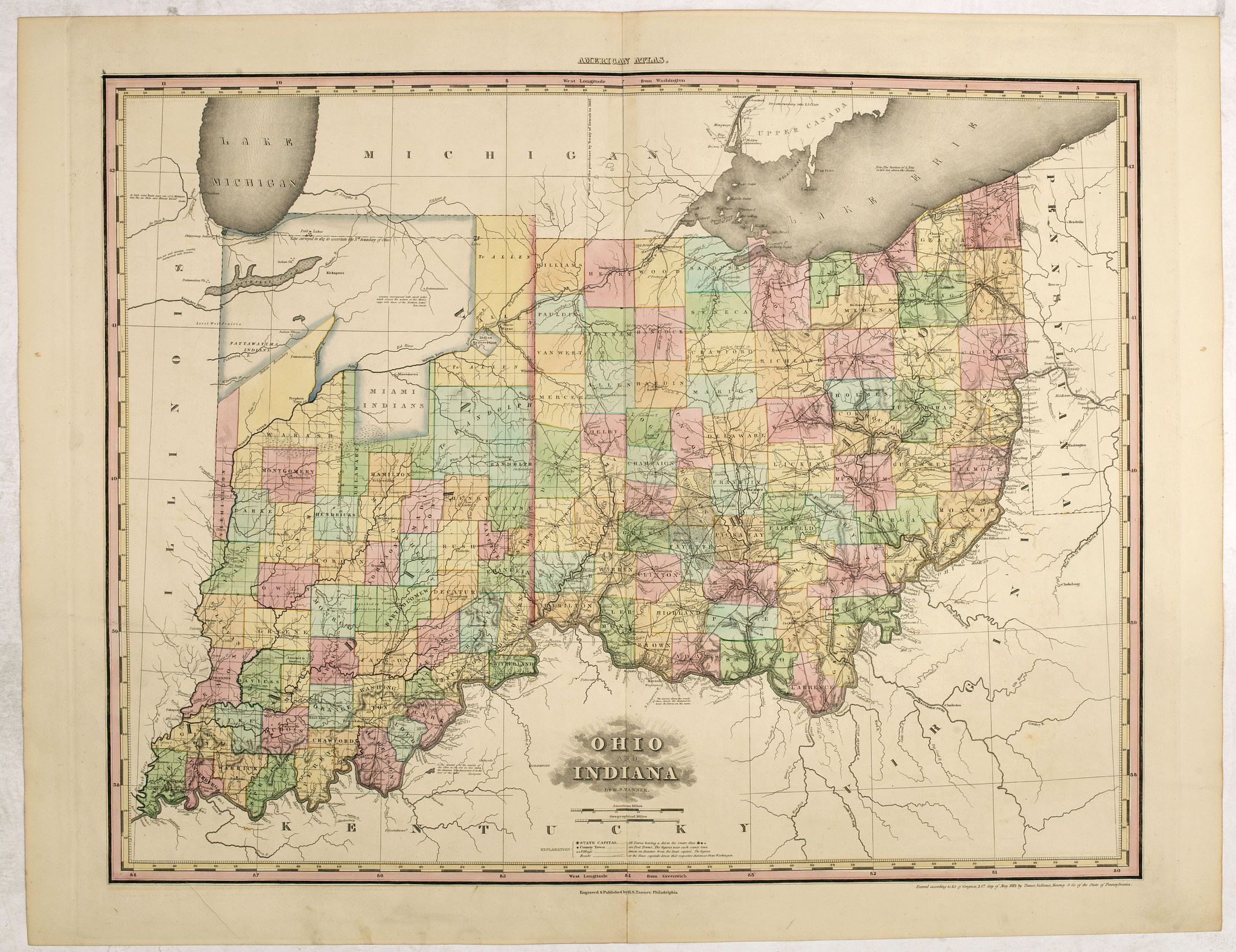
1823 TANNER, H.S. - Ohio and Indiana by H.S. Tanner.
Ohio and Indiana by H.S. Tanner. |
||||||||||||||||||||
|
||||||||||||||||||||
|
|
||||||||||||||||||||
$1900 / ≈ €1695
This item is available for immediate sale
|
My Collection +
Add this or any of your favorite items in one place. If you want to save the items permanently, you have to sign in or create an account first.   Add/Remove
 |
|||||||||||||||||||



Description
The third state of this rare and important map of Ohio and Indiana by H.S. Tanner and published in his "New American Atlas".
The rare first edition with "Miami Indians" and "Indian Reservation" in the Northwest part of Indiana while dates May 24, 1819, its inclusion of Randolph County, Indiana suggests that it was completed in or after August 1818, when Randolph County was first created, but before January 1, 1819, when Owen County was created from the Northern Part of Sullivan County, Indiana.
Many Indian settlements are shown in the north. While the county system in Ohio is more complete, there are still many signs of earlier days, including notes of British & American Forts and Indian Villages. Extensive notes on roads, rivers and many other features. An essential map for Midwest collectors.
The third state adds a number of new counties, including Randolph County, the first to extend as far north as the Maumee River. There are two northern boundaries of Indiana shown. A note indicates that boats may pass from Lake Michigan to the Au Plain River at high tide, near Ft. Dearborn, which is connected to Ft. Wayne by a road.
Henry Schenck Tanner (1786-1858) was born in New York City but removed early to Philadelphia. Trained as an engraver, he engraved many of his maps in the 1804 edition of A New and Elegant General Atlas of Arrowsmith and Lewis. He engraved the frontispiece and many of the maps in John Melish's Military and Topographical Atlas of the United States (1813 and 1815). and with J.Vallance, engraved Melish's fundamental "Map of the United States" (1816), the text accompanying which shaped Tanner's thought. In 1818-1823 he published A New American Atlas, in parts, which went to many editions.
Contemporary reviews of the atlas were favourable: the New American Atlas "is decidedly one of the most splendid works of the kind ever executed in this country" (United States Gazette, September 1823). Never "has either America or Europe, produced a geographical description of the several States of the Union, so honorable to the Arts, and so creditable to the nation as Tanner's American Atlas." (National Advocate 25 August 1824). Perhaps the most enthusiastic report came from the scholar Jared Sparks who wrote in the April 1824 issue of the North American Review that "as an American Atlas, we believe Mr. Tanner's work to hold a rank far above any other, which has been published."
Read more about Henry S. Tanner [+]
Reference: Phillips, Maps p. 599. Ristow, American Maps and Mapmakers, 191-198.
Henry Schenck Tanner (1786-1858)
Henry Schenck Tanner was born in New York City in 1786 and lived most of his life in Philadelphia, which was then the centre of engraving and publishing in America. He worked almost entirely in cartography for more than forty years during what is considered the “Golden Age of American Map Publishing.” Early in his career, he partnered with his brother Benjamin to engrave extensively for Melish and other Philadelphia publishers. He should not be confused with his brother, the New York engraver Benjamin Tanner (b. 1775). Tanner died on 18 May 1858.In 1818, Tanner convinced his fellow publishers and partners to finance the compilation of a New American Atlas. It was sold by subscription and appeared gradually between 1819 and 1823. It is regarded as the largest and most beautiful early American atlas and possibly the pinnacle of 19th-century American cartography.
In its day it was commended as “one of the most splendid works of the kind ever executed in this country.”
Walter Ristow wrote that its size, format, printing and paper quality, cartographic accuracy and elegance of engraving were unparalleled. Maps include the world on Mercator’s projection (1823, 1825 editions) and Pennsylvania and New Jersey (1823). By this time, Tanner had become the most active and influential map publisher in the United States. The atlas was reissued in later editions (1825 and after).
- New Universal Atlas (from c. 1832): a smaller-format, less costly atlas. It was popular and went through numerous editions before being bought out by Carey & Hart and then, in 1846, by S. Augustus Mitchell.
- Wall map of the United States (1829): one of the most important American maps of the 19th century. It identifies American Indian nations as “districts,” especially in the Trans-Mississippi region, and includes insets of cities and regional maps (south Florida, Oregon and Mandan). Tanner thereby initiated a new age of quintessentially American cartography.
- Travellers’ guides and pocket maps: The Traveller’s Guide, or Map of the Roads, Canals and Rail Roads of the United States (1846), a pocket map for use en route.
FAQ - Guarantee - Shipping
This item is available for immediate purchase when a "Add to Cart" or "Inquire Now" button is shown.
Items are sold in the EU margin scheme
Payments are accepted in Euros or US Dollars.
Authenticity Guarantee
 We provide professional descriptions, condition report (based on 45 years experience in the map business)
Paulus Swaen warrants the authenticity of our items and a certificate of authenticity is provided for each acquired lot.
Condition and Coloring
We indicate the condition of each item and use our unnique HiBCoR grading system in which four key items determine a map's value: Historical Importance, Beauty, Condition/Coloring and Rarity.
Color Key
We offer many maps in their original black and white condition. We do not systematically color-up maps to make them more sellable to the general public or buyer.
Copper engraved or wood block maps are always hand colored. Maps were initially colored for aesthetic reasons and to improve readability. Nowadays, it is becoming a challenge to find maps in their original colors and are therefor more valuable.
We use the following color keys in our catalog:
Original colors; mean that the colors have been applied around the time the map was issued.
Original o/l colors; means the map has only the borders colored at the time of publication.
Colored; If the colors are applied recently or at the end of the 20th century.
Read more about coloring of maps [+]
Shipping fee
A flat shipping fee of $ 30 is added to each shipment by DHL within Europe and North America. This covers : International Priority shipping, Packing and Insurance (up to the invoice amount).
Shipments to Asia are $ 40 and rest of the world $50
We charge only one shipping fee when you have been successful on multiple items or when you want to combine gallery and auction purchases.
Read more about invoicing and shipping
FAQ
Please have a look for more information about buying in the BuyNow gallery
Many answers are likely to find in the general help section.
My Collection+

With My Collection+ you can collect all your favorite items in one place. It is free, and anyone can create his or her virtual collection.
Unless you are logged in, the item is only saved for this session. You have to be registed and logged-in if you want to save this item permanently to My Collection+. Read More[+]
Register here, it is free and you do not need a credit card.
Add this item to My Collection+ or click the following link to see My Collection+.
|
Digital Image Download Paulus Swaen maintains an archive of most of our high-resolution rare maps, prints, posters and medieval manuscript scans. We make them freely available for download and study. Read more about free image download |
Click the image for a free small image download. |
YOUR RIGHT TO CANCEL THE PURCHASE OF A LOT
In accordance with the EU Consumer Rights Directive and habitually reside in the European Union you have the right to cancel the contract for the purchase of a lot, without giving any reason.
The cancellation period will expire 14 calendar days from the day after the date on which you or a third party (other than the carrier and indicated by you) acquires, physical possession of the lot. To exercise the right to cancel you must inform Paulus Swaen Inc, of your decision to cancel this contract by a clear statement (e.g. a letter sent by post, or e-mail.
To meet the cancellation deadline, it is sufficient for you to send your communication concerning your exercise of the right to cancel before the cancellation period has expired.
