Karte von dem groessten Theil des Landes Jemen Imame, Kaukeban &c. |
||||||||||||||||||||
|
||||||||||||||||||||
|
|
||||||||||||||||||||
$250 / ≈ €220This item is available for immediate sale! Questions before Buying ?
We are happy to answer your questions. |
My Collection +
Add this or any of your favorite items in one place. If you want to save the items permanently, you have to sign in or create an account first. |
|||||||||||||||||||
Description
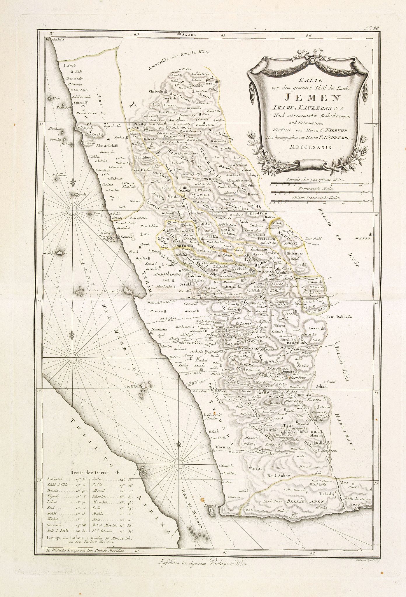
Large map of Yemen from "Allgemeiner grosser Atlas" published by P. J. Schalbacher - 1786-1800. Based on the observations of the Danish explorer Carsten Niebuhr and shows the eastern shore of the Red Sea just to the north of Jizan. Numerous towns, cities, and Wadis are shown interlaced in the dense hachuring to suggest topography.
The Red Sea is filled with three compass roses, fleur-de-lis and rhumb lines. In the lower left an index gives latitude and longitude for the major cities.
At upper right is an elaborate title cartouche with three distance scales below.
FAQ - Guarantee - Shipping
Buying in the BuyNow Gallery
This item is available for immediate purchase when a "Add to Cart" or "Inquire Now" button is shown.
Items are sold in the EU margin scheme
Payments are accepted in Euros or US Dollars.
Authenticity Guarantee
 We provide professional descriptions, condition report (based on 45 years experience in the map business)
Paulus Swaen warrants the authenticity of our items and a certificate of authenticity is provided for each acquired lot.
Condition and Coloring
We indicate the condition of each item and use our unnique HiBCoR grading system in which four key items determine a map's value: Historical Importance, Beauty, Condition/Coloring and Rarity.
Color Key
We offer many maps in their original black and white condition. We do not systematically color-up maps to make them more sellable to the general public or buyer.
Copper engraved or wood block maps are always hand colored. Maps were initially colored for aesthetic reasons and to improve readability. Nowadays, it is becoming a challenge to find maps in their original colors and are therefor more valuable.
We use the following color keys in our catalog:
Original colors; mean that the colors have been applied around the time the map was issued.
Original o/l colors; means the map has only the borders colored at the time of publication.
Colored; If the colors are applied recently or at the end of the 20th century.
Read more about coloring of maps [+]
Shipping fee
A flat shipping fee of $ 30 is added to each shipment by DHL within Europe and North America. This covers : International Priority shipping, Packing and Insurance (up to the invoice amount).
Shipments to Asia are $ 40 and rest of the world $50
We charge only one shipping fee when you have been successful on multiple items or when you want to combine gallery and auction purchases.
Read more about invoicing and shipping
FAQ
Please have a look for more information about buying in the BuyNow gallery
Many answers are likely to find in the general help section.
My Collection+
![]()
With My Collection+ you can collect all your favorite items in one place. It is free, and anyone can create his or her virtual collection.
Unless you are logged in, the item is only saved for this session. You have to be registed and logged-in if you want to save this item permanently to My Collection+.
Read More[+]
Register here, it is free and you do not need a credit card.
Add this item to
My Collection+
or click the following link to see My Collection+.
| Digital Image Download | |
|
Paulus Swaen maintains an archive of most of our high-resolution rare maps, prints, posters and medieval manuscript scans. We make them freely available for download and study. Read more about free image download |
Click the image for a free small image download. |
In accordance with the EU Consumer Rights Directive and habitually reside in the European Union you have the right to cancel the contract for the purchase of a lot, without giving any reason.
The cancellation period will expire 14 calendar days from the day after the date on which you or a third party (other than the carrier and indicated by you) acquires, physical possession of the lot. To exercise the right to cancel you must inform Paulus Swaen Inc, of your decision to cancel this contract by a clear statement (e.g. a letter sent by post, or e-mail.
To meet the cancellation deadline, it is sufficient for you to send your communication concerning your exercise of the right to cancel before the cancellation period has expired.
Recently Viewed

Paskaerte Zynde t'Oosterdeel Van Oost Indien, met alle de Eylanden daer ontrendt geleegen van C. Comorin tota aen Iapan.
1669 Pieter Goos ' eye-catching chart of Australia, Southeast Asia, China, Japan, Korea, and India. (With gold highlights.)
Date: Amsterdam, 1669

Karte von dem groessten Theil des Landes Jemen Imame, Kaukeban &c.
Large map of Yemen from "Allgemeiner grosser Atlas" published by P. J. Schalbacher - 1786-1800. Based on the observations of the Danish explorer Carsten Niebuhr...
Date: Vienna, 1789
![Manière dont on expose les morts à Otahiti. [Tome II Pl. 16.]](/uploads/cache/26113-250x250.jpg)
Manière dont on expose les morts à Otahiti. [Tome II Pl. 16.]
A view of a Tahitian funeral home in a beautiful landscape. Engraved by Demouchy. From the French edition of James Cook's first voyage entitled Relation des voyages entre...
Date: Paris, 1773
