Sign In or Sign Up
Subscribe to be notified if similar examples become available.
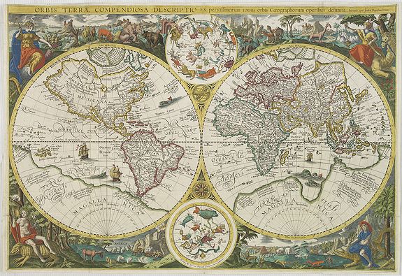
Orbis terrae compendiosa descriptio. . . |
||||||||||||||||||||
|
||||||||||||||||||||
|
|
||||||||||||||||||||
|
|
My Collection +
Add this or any of your favorite items in one place. If you want to save the items permanently, you have to sign in or create an account first. |
|||||||||||||||||||
Description
Very rare large double hemisphere world map, with the address of Joan Baptistum Vrients, made for the first edition of Linschoten's "Itinerario" (1596) published by Cornelis Claesz. The map was engraved by the Dutch master engravers Arnold and Hendrik Van Langren,
The map is a close copy of Plancius' separately published world map of 1594.
This 1594 edition is known to be the oldest existing map in Europe that made reference to Korea with the marking "Corea." (There are two earlier maps, drawn by Bartholomeu Velho in 1562 and by Abraham Ortelius in the 1580s that show the Korean Peninsula but they gave no specific name to the peninsula.)
The 1594 map became more widely available since after 1599 the copperplate was used in subsequence editions of the "Itenerario".
When Claes published his first edition of the "Itenerario" in 1596 he included this map who is a close copy of Plancius' 1594 edition. This much rarer edition differences from the Plancius edition in the northern seas. The pictorial scenes forming the outer border have been regrouped with even greater stylistic effect. Below the double hemispheres Mexicana and Peruvana have been combined to form a single America, and the fictional Magellanica omitted in favor of a full-panel Africa. The overall engraving is much finer that that of the map engraved by Jan van Doetecum.
The 1594 edition was published separately and no copies are known to exists; making this edition of Plancius world map the first obtainable map making reference to "Corea". Showing Korea as an peninsular.
Linschoten had been in Portuguese service in the East Indies for nearly ten years. Jan Huygen van Linschoten lived since 1579 as a merchant in Spain and from 1583-1598 as secretary from the Portuguese archbishop in Goa. There he succeeded with the help of Dirck Gerritszoon Pomp, nicknamed "Dirck China " to retrieve the secret sail instructions, with the help of which the Portuguese ships sailed there from harbor to harbor. Pomp, a Hollander, also in the service of the Portuguese, went to sea in 1584 aboard the Portuguese vessel "Santa Cruz". The ship was richly laden with merchandise and had sailed by way of the trade-settlement in Goa, India, to Macao in China and from there to Japan. He arrived in Nagasaki in 1585, perhaps the first Hollander to set foot on Japanese territory. Dirck gave oral information to Jan van Linschoten.
The Itenerario gives valuable information about Corea. He wrote: "so stretches the coast [from Japan] again to the north, recedes after that inward, northwest ward, to which Coast those from Japan trade with the Nation which is called Cooray, from which I have good, comprehensive and true information, as well as from the navigation to this Country, from the pilots, who investigated the situation there and sailed there."
In the Itinerary , which was published one year later, at page 37 we will find the following extract:
"A little above Japan, on 34 and 35 degrees, not far from the coast of China, is another big island, called Insula de Core, from which until now, there is no certainty concerning size, people, nor what trade there is."
Later at page 70 he writes more about it:
"From this corner from the bay of Nanquin 20 miles southeast onwards, there lay several islands with at the end, of which, to know, on the east side lies a very big and high island [This Island is] by many people inhabited, as well as on foot as on horseback. [sic!] These Islands are called by the Portuguese as Ylhas de Core, or the Islands of Core, but the islands, as previously described, is called Chausien, has from one side to the northwest a small indentation.
There's also a small island in the mouth, which is the harbor, but has little deepness, here the lord of the country has his residency. From this main Island off, 25 miles southeast onward, lays the island of Goto, one of the islands of Japan, which lies at the corner of the indentation from the bay of Nanquin off, east to north seaward on, 60 miles or little more." (Jan Huyghen van Linschoten, Reys-Gheschrift van de Navigatien der Portugaloysers in Orienten enz. [1595], bl. 70). [The original text can be interpreted in several ways, so the text is given in a literal translation]
The Vrients edition is also considerably rarer than its predecessor, receiving an R rating in Shirley. Although the two maps are very close geographically, they are far from identical. The Vrients added a crucial place name not found on the original "Banda" the island group in the East Indies that was the key source for the most sought after commodity of the age spices.
Also, the mapping of Nova Zembla, the northern coast of Asia, and the North Sea are significantly different on the two maps. Both maps provided an up-to-date portrait of the world.
This is particularly apparent in the mapping of Asia, where, for example, Korea is correctly shown as a peninsula, and Japan is well drawn for the period. In North America, "Virginia" appears at a relatively early date.
Reference: Shirley, World 192
FAQ - Guarantee - Shipping
Buying in the BuyNow Gallery
This item is available for immediate purchase when a "Add to Cart" or "Inquire Now" button is shown.
Items are sold in the EU margin scheme
Payments are accepted in Euros or US Dollars.
Authenticity Guarantee
 We provide professional descriptions, condition report (based on 45 years experience in the map business)
Paulus Swaen warrants the authenticity of our items and a certificate of authenticity is provided for each acquired lot.
Condition and Coloring
We indicate the condition of each item and use our unnique HiBCoR grading system in which four key items determine a map's value: Historical Importance, Beauty, Condition/Coloring and Rarity.
Color Key
We offer many maps in their original black and white condition. We do not systematically color-up maps to make them more sellable to the general public or buyer.
Copper engraved or wood block maps are always hand colored. Maps were initially colored for aesthetic reasons and to improve readability. Nowadays, it is becoming a challenge to find maps in their original colors and are therefor more valuable.
We use the following color keys in our catalog:
Original colors; mean that the colors have been applied around the time the map was issued.
Original o/l colors; means the map has only the borders colored at the time of publication.
Colored; If the colors are applied recently or at the end of the 20th century.
Read more about coloring of maps [+]
Shipping fee
A flat shipping fee of $ 30 is added to each shipment by DHL within Europe and North America. This covers : International Priority shipping, Packing and Insurance (up to the invoice amount).
Shipments to Asia are $ 40 and rest of the world $50
We charge only one shipping fee when you have been successful on multiple items or when you want to combine gallery and auction purchases.
Read more about invoicing and shipping
FAQ
Please have a look for more information about buying in the BuyNow gallery
Many answers are likely to find in the general help section.
My Collection+
![]()
With My Collection+ you can collect all your favorite items in one place. It is free, and anyone can create his or her virtual collection.
Unless you are logged in, the item is only saved for this session. You have to be registed and logged-in if you want to save this item permanently to My Collection+.
Read More[+]
Register here, it is free and you do not need a credit card.
Add this item to
My Collection+
or click the following link to see My Collection+.
| Digital Image Download | |
|
Paulus Swaen maintains an archive of most of our high-resolution rare maps, prints, posters and medieval manuscript scans. We make them freely available for download and study. Read more about free image download |
Click the image for a free small image download. |
In accordance with the EU Consumer Rights Directive and habitually reside in the European Union you have the right to cancel the contract for the purchase of a lot, without giving any reason.
The cancellation period will expire 14 calendar days from the day after the date on which you or a third party (other than the carrier and indicated by you) acquires, physical possession of the lot. To exercise the right to cancel you must inform Paulus Swaen Inc, of your decision to cancel this contract by a clear statement (e.g. a letter sent by post, or e-mail.
To meet the cancellation deadline, it is sufficient for you to send your communication concerning your exercise of the right to cancel before the cancellation period has expired.
