Sign In or Sign Up
Sign In or Sign Up
Subscribe to be notified if similar examples become available.
1670 SANSON, N. / MARIETTE, P. - [ Set of 2 maps ] Abbregé de la Carte de la Chine du R.P. Martinius Jesuiste / du R.P. Bouyn Jesuiste.
[ Set of 2 maps ] Abbregé de la Carte de la Chine du R.P. Martinius Jesuiste / du R.P. Bouyn Jesuiste.
| Maker: | SANSON, N. / MARIETTE, P. | |
| Date: | Paris, 1670 | |
| Colored: | In original colors with later color addition. | |
| Size: | 200 x 235 mm / 7.9 x 9.3 inches | |
| Condition: | Two maps in fine condition, one 200x235mm and the other 225x245mm. | |
Selling price: $ Please login to see price!
Sold in 2009
Missed this item !
Add your name to our mailing list and be the first to get notified about our newly added listings.
.
You can choose from more than 30,000 items from our BuyNow Catalog or Archive.
It's free, and you can delete items anytime.
 Add/Remove this item to MyCollection+




Description
Extremely rare set of maps by Nicolas Sanson. Unlike most mapmakers, who readily adopted Martini’s map of China after it appeared in Blaeu's Novus Atlas Sinensis in 1655, Sanson remained reluctant to fully embrace the new projection. Instead, he chose to adopt the map attributed to the Jesuit Michele Ruggieri from 1656 onwards.
Nevertheless, one map based on Martini’s projection was printed in Sanson's name in 1670, as well as another, which is the only printed version of Michael Boym's unusual map of China. Boym (or "Bouyn" on Sanson's map) was a Polish Jesuit who travelled extensively throughout China and had intended to produce his own atlas of China entitled Magni Cathay.
Unfortunately, Boym's work never progressed past the manuscript stage, and his work has only survived in printed form through this map by Sanson. These two maps represent a fascinating period of debate and uncertainty in the history of the European mapping of China.
Nicolas Sanson d'Abbeville / Pierre Mariette
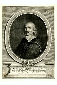 Nicolas Sanson d'Abbeville was an ordinary geographer to the kings Louis XIII and Louis XIV, and the founder of the French school of cartography. While the Dutch atlases of Blaeu and Janssonius were works of engravers, Sanson's maps were works of geographers: sober, methodical, grounded in sources, and organized by political divisions. His America of 1650 introduced the island of California in its second form and the five Great Lakes; his quarto atlases of the continents (1656 to 1657) were copied for a century, in Amsterdam by Anthonie de Winter for the Dutch edition of De la Croix.
Pierre Mariette Pierre Mariette was a bookseller, print seller, printer and publisher on the Rue Saint-Jacques in Paris. He was an established print dealer and engraver who turned to cartography when, on 12 February 1644, he acquired most of the stock of Melchior Tavernier, with whom Sanson had previously worked. Mariette’s death is dated 1657 or 1658, and his birth 1569 or 1602, depending on the source.
From about 1644 to 1648, Mariette partnered with Sanson. Sanson drew the maps and obtained the rights, while Mariette engraved them and financed the expensive printing. His business sense and ready capital enabled Sanson to publish an enormous quantity of maps. The finished copperplates were split between them so that neither could publish an atlas without the other’s assent.
The relationship was amicable until Mariette’s death, after which disputes arose between Sanson and Mariette’s heirs. The disagreement with Pierre II Mariette culminated in 1671, when Sanson’s son Guillaume took the case to court.
As a result, some printings carry the Mariette imprint, some the Sanson imprint, and some both. Later, Pierre Moullart-Sanson revived publication of the world atlas, and in 1704 he obtained a privilege for all the works of Nicolas and Guillaume Sanson, which continued to be published until 1730.
FAQ - Guarantee - Shipping
This item is available for immediate purchase when a "Add to Cart" or "Inquire Now" button is shown.
Items are sold in the EU margin scheme
Payments are accepted in Euros or US Dollars.
Authenticity Guarantee
 We provide professional descriptions, condition report (based on 45 years experience in the map business)
Paulus Swaen warrants the authenticity of our items and a certificate of authenticity is provided for each acquired lot.
Condition and Coloring
We indicate the condition of each item and use our unique HiBCoR grading system in which four key items determine a map's value: Historical Importance, Beauty, Condition/Coloring and Rarity.
Color Key
We offer many maps in their original black and white condition. We do not systematically color-up maps to make them more sellable to the general public or buyer.
Copper engraved or wood block maps are always hand colored. Maps were initially colored for aesthetic reasons and to improve readability. Nowadays, it is becoming a challenge to find maps in their original colors and are therefor more valuable.
We use the following color keys in our catalog:
Original colors; mean that the colors have been applied around the time the map was issued.
Original o/l colors; means the map has only the borders colored at the time of publication.
Colored; If the colors are applied recently or at the end of the 20th century.
Read more about coloring of maps [+]
Shipping fee
A flat shipping fee of $ 30 is added to each shipment by DHL within Europe and North America. This covers : International Priority shipping, Packing and Insurance (up to the invoice amount).
Shipments to Asia are $ 40 and rest of the world $50
We charge only one shipping fee when you have been successful on multiple items or when you want to combine gallery and auction purchases.
Read more about invoicing and shipping
FAQ
Please have a look for more information about buying in the BuyNow gallery
Many answers are likely to find in the general help section.
MyCollection+

With My Collection+ you can collect all your favorite items in one place. It is free, and anyone can create his or her virtual collection.
Unless you are logged in, the item is only saved for this session. You have to be registered and logged-in if you want to save this item permanently to My Collection+. Read More[+]
Register here, it is free and you do not need a credit card.
Add this item to My Collection+ or click the following link to see My Collection+.
|
Digital Image Download Paulus Swaen maintains an archive of most of our high-resolution rare maps, prints, posters and medieval manuscript scans. We make them freely available for download and study. Read more about free image download |
Click the image for a free small image download. |

YOUR RIGHT TO CANCEL THE PURCHASE OF A LOT
In accordance with the EU Consumer Rights Directive and habitually reside in the European Union you have the right to cancel the contract for the purchase of a lot, without giving any reason.
The cancellation period will expire 14 calendar days from the day after the date on which you or a third party (other than the carrier and indicated by you) acquires, physical possession of the lot. To exercise the right to cancel you must inform Paulus Swaen Inc, of your decision to cancel this contract by a clear statement (e.g. a letter sent by post, or e-mail.
To meet the cancellation deadline, it is sufficient for you to send your communication concerning your exercise of the right to cancel before the cancellation period has expired.
