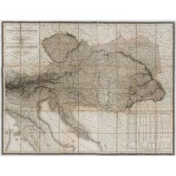
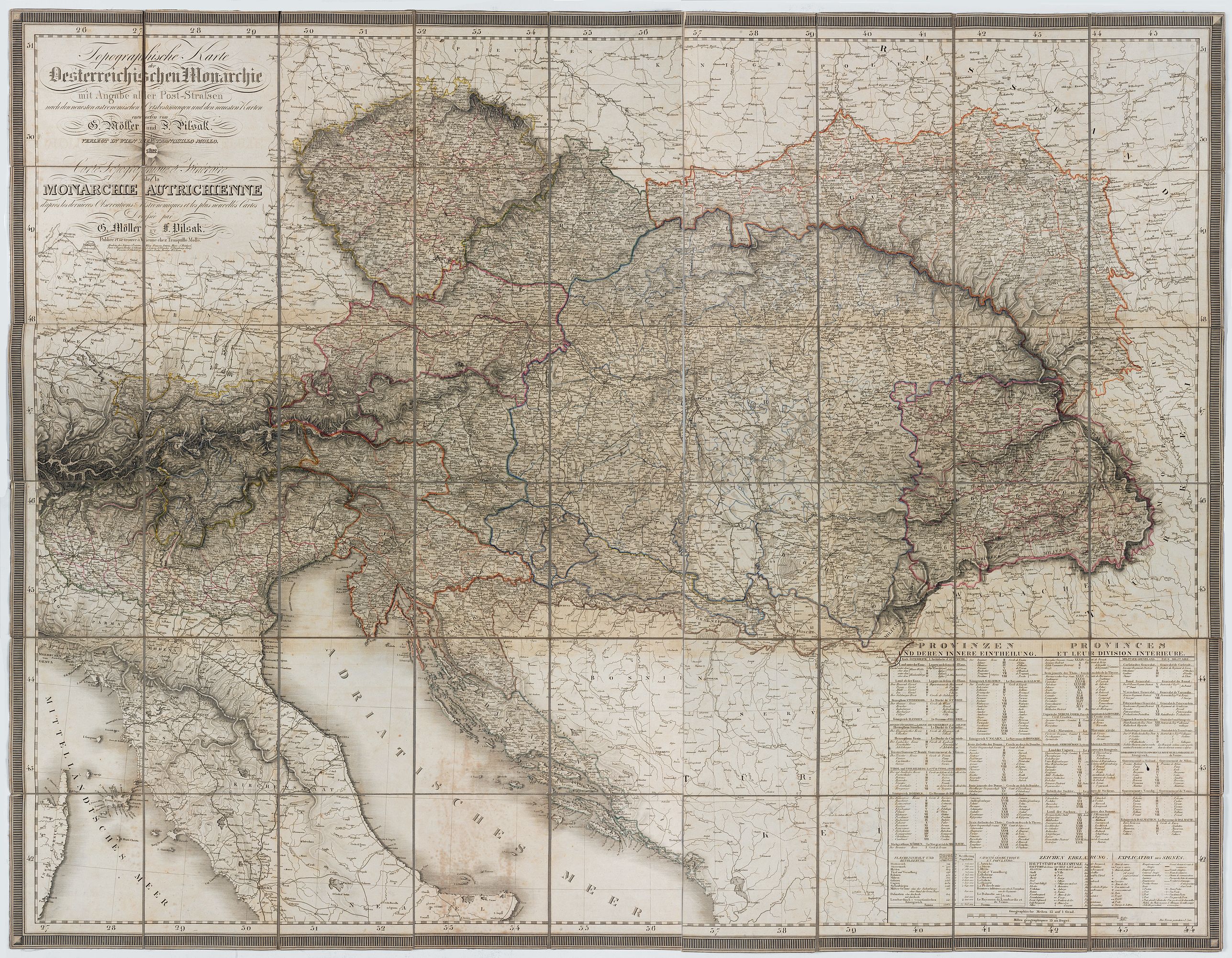
Topographische Karte dere Oestreichischen Monarchie mit angabe aller Post-Strassen… |
||||||||||||||||||||
|
||||||||||||||||||||
|
|
||||||||||||||||||||
$1000 / ≈ €873
This item is available for immediate sale
1000.00
|
My Collection + - Save and collect this or any of your favorite items in one place.
If you want to save the items permanently, please sign in or create account first. |
|||||||||||||||||||
Description
This detailed copperplate map of Central Europe and the Austria-Hungarian Monarchy is the first edition, engraved by I. Zutz and printed to a scale of 1:150,000 by Tranquillo Mollo in Vienna. The title has a date 1822. It includes Austria, as well as parts of Poland, Hungary, Germany, and Italy. Published in three editions up to 1830, each reflected updates from the period. Intended to compete with Ludwig A. von Fallon’s contemporary map, it features clear engraving typical of Mollo’s works.
The lower-right margin lists provinces and districts in German and French, along with their sizes and populations. The two authors are otherwise unknown; this appears to be their only cartographic publication.
Post road maps
Beginning in the seventeenth century, particularly in Western Europe and Northern Italy, governments realized that an improved road system would help with economic development and governmental administration and would enable a reliable postal system.
While roads remained relatively primitive into the eighteenth century, by the middle of the seventeenth century, improvements allowed for the use of wheeled coaches and wagons, which led to the development of coach service between towns.
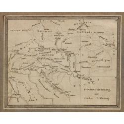
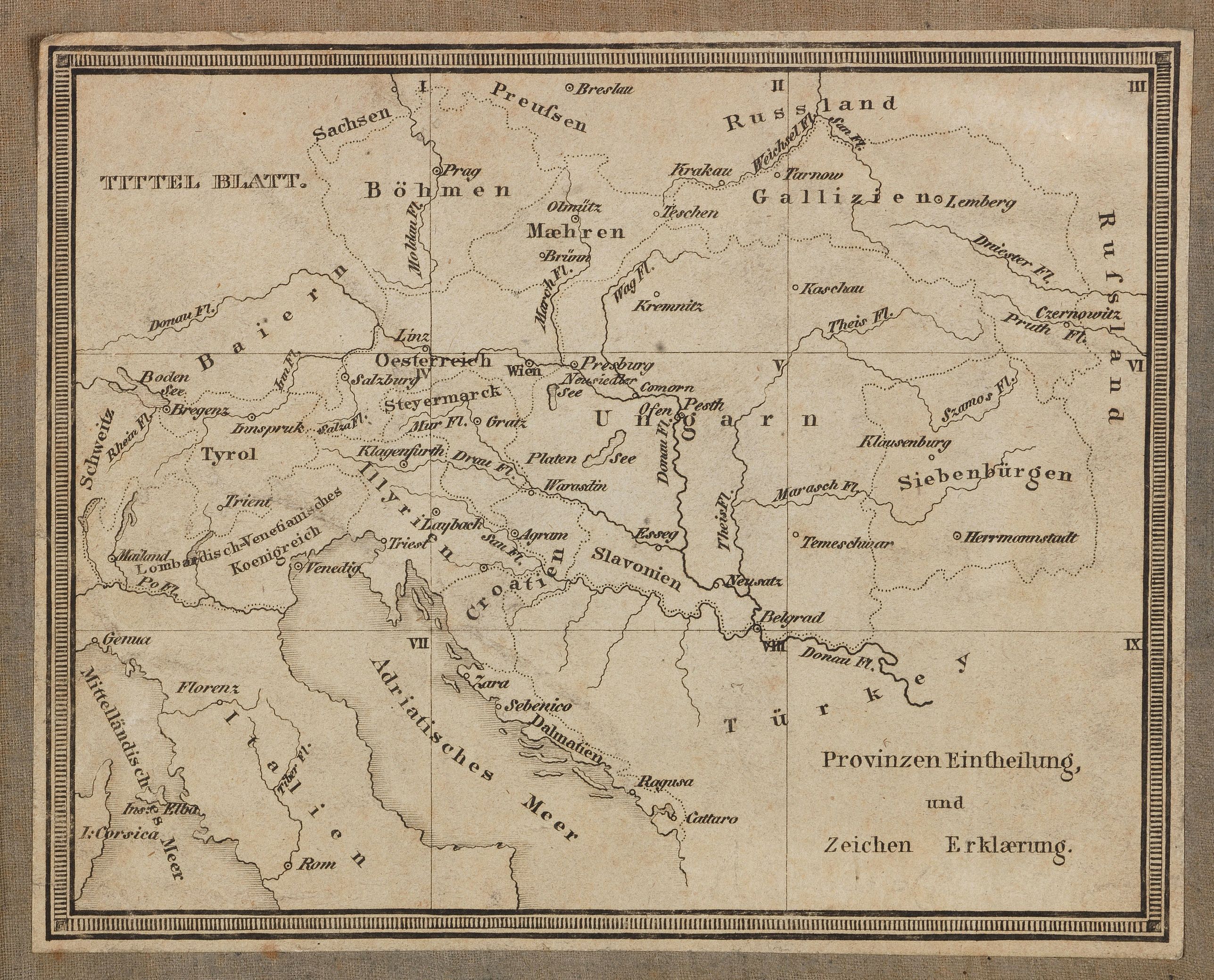
These coaches were primarily provided by the public mail service which was designed to carry letters, packages and people. Indeed, until the nineteenth century, most passenger coach travel was monopolized by postal carriers.On verso a small key-map (13x17cm.) has been pasted.
Interesting reading: Werner Elias. "Road Maps for Europe's Early Post Routes 1630-1780" in Map Collector, No. 16, pp. 30ff. (1981), and "Maps and Road Books of Europe's Mail Coach Era 1780-1850" in Map Collector, No. 20, pp. 24ff. (1982).
More about folding maps or Post road maps. [+]
FAQ - Guarantee - Shipping
Buying in the BuyNow Gallery
This item is available for immediate purchase when a "Add to Cart" or "Inquire Now" button is shown.
Items are sold in the EU margin scheme
Payments are accepted in Euros or US Dollars.
Authenticity Guarantee
 We provide professional descriptions, condition report (based on 45 years experience in the map business)
Paulus Swaen warrants the authenticity of our items and a certificate of authenticity is provided for each acquired lot.
Condition and Coloring
We indicate the condition of each item and use our unnique HiBCoR grading system in which four key items determine a map's value: Historical Importance, Beauty, Condition/Coloring and Rarity.
Color Key
We offer many maps in their original black and white condition. We do not systematically color-up maps to make them more sellable to the general public or buyer.
Copper engraved or wood block maps are always hand colored. Maps were initially colored for aesthetic reasons and to improve readability. Nowadays, it is becoming a challenge to find maps in their original colors and are therefor more valuable.
We use the following color keys in our catalog:
Original colors; mean that the colors have been applied around the time the map was issued.
Original o/l colors; means the map has only the borders colored at the time of publication.
Colored; If the colors are applied recently or at the end of the 20th century.
Read more about coloring of maps [+]
Shipping fee
A flat shipping fee of $ 30 is added to each shipment by DHL within Europe and North America. This covers : International Priority shipping, Packing and Insurance (up to the invoice amount).
Shipments to Asia are $ 40 and rest of the world $50
We charge only one shipping fee when you have been successful on multiple items or when you want to combine gallery and auction purchases.
Read more about invoicing and shipping
FAQ
Please have a look for more information about buying in the BuyNow gallery
Many answers are likely to find in the general help section.
My Collection+
![]()
With My Collection+ you can collect all your favorite items in one place. It is free, and anyone can create his or her virtual collection.
Unless you are logged in, the item is only saved for this session. You have to be registed and logged-in if you want to save this item permanently to My Collection+.
Read More[+]
Register here, it is free and you do not need a credit card.
Add this item to
My Collection+
or click the following link to see My Collection+.
| Digital Image Download | |
|
Paulus Swaen maintains an archive of most of our high-resolution rare maps, prints, posters and medieval manuscript scans. We make them freely available for download and study. Read more about free image download |
Click the image for a free small image download. |
In accordance with the EU Consumer Rights Directive and habitually reside in the European Union you have the right to cancel the contract for the purchase of a lot, without giving any reason.
The cancellation period will expire 14 calendar days from the day after the date on which you or a third party (other than the carrier and indicated by you) acquires, physical possession of the lot. To exercise the right to cancel you must inform Paulus Swaen Inc, of your decision to cancel this contract by a clear statement (e.g. a letter sent by post, or e-mail (amsterdam@swaen.com).
To meet the cancellation deadline, it is sufficient for you to send your communication concerning your exercise of the right to cancel before the cancellation period has expired.
