Subscribe to be notified if similar examples become available.
Prussiae Regionis Sarmatiae Europae Nobilissimae Novaet vera descriptio . . . |
||||||||||||||||||||
|
||||||||||||||||||||
|
|
||||||||||||||||||||
|
Selling price: $ Please login to see price!
Sold in 2018 Missed this item! Add your name to our mailing list and be the first to get notified about our newly added listings. . |
My Collection +
Add this or any of your favorite items in one place. If you want to save the items permanently, you have to sign in or create an account first. |
|||||||||||||||||||
Description
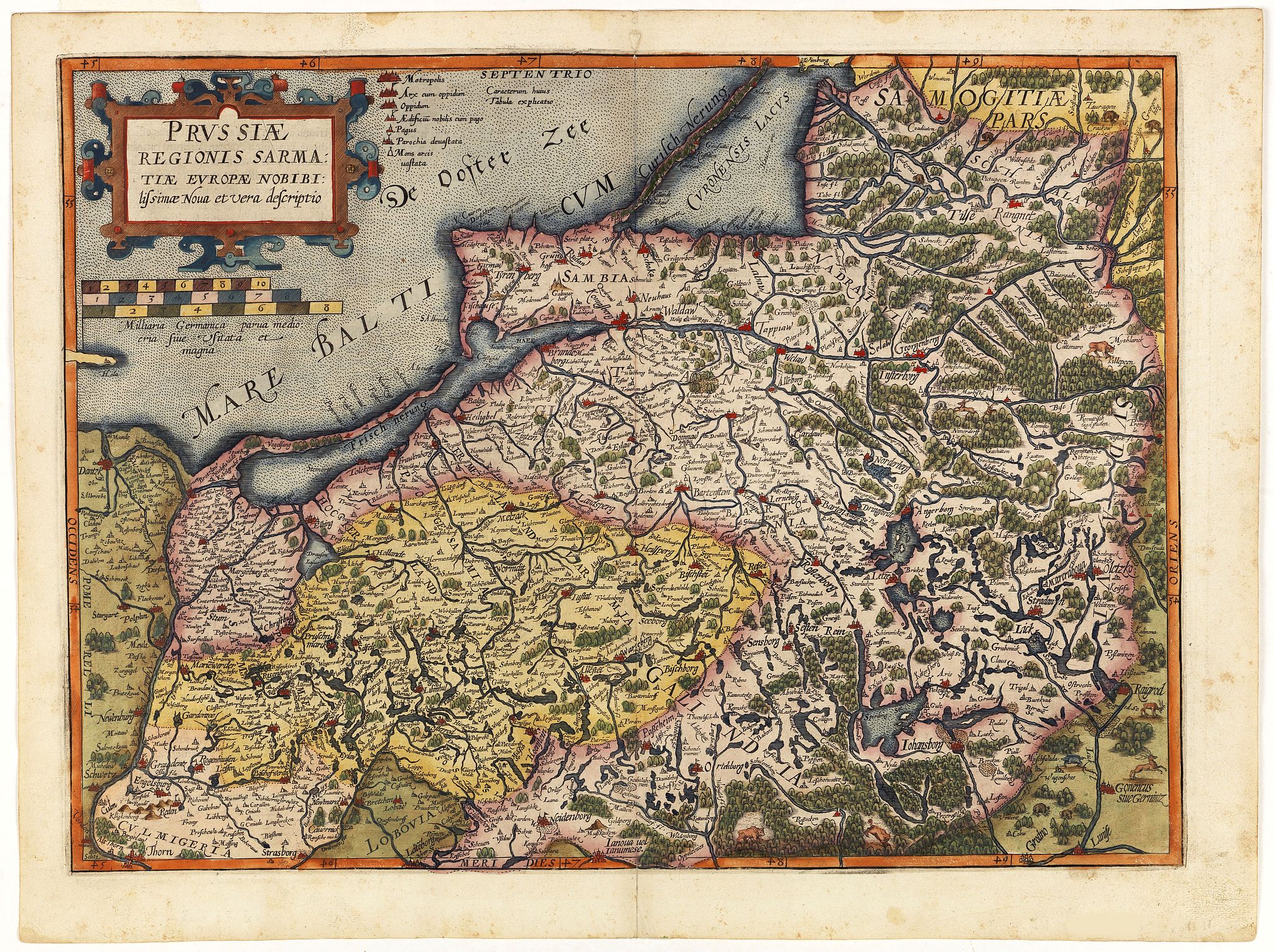
Nice example of the first edition of De Jode's map of Prussia, from the 1593 edition of De Jode's atlas.
The present map is an entirely new addition to the second De Jode atlas, the Speculum Orbis Terrae (1593). The geography is based on Caspar Henneberger's groundbreaking 1576 woodcut map of Prussia. The map extends from Gdansk (Danzig) in the west to Lithuania in the east, and De Jode employs an especially vibrant engraving style to express northeastern Poland's numerous forests, lakes and rivers.
Gerard De Jode (1521-91) created some of the most geographically progressive and beautifully engraved maps of the 16th-century. Born in Nijmegen, he made his way to the great commercial center of Antwerp, where his joined the Guild of St. Luke in 1547. In 1564, he printed Abraham Ortelius' famous eight-sheet cordiform World map. Inspired by the success of Ortelius' Theatrum Orbis Terrarum (1570), De Jode set out to produce his own atlas. However, Ortelius used his extensive political connections to ensure that De Jode's efforts were obstructed, for his grant of a royal publishing privilege was delayed for 5 years. Finally, in 1578, De Jode published his magnificent 2-volume atlas, the Speculm Orbis Terrarum. De Jode's maps were based on the very best geographic sources, and employed artistically virtuous design rendered with the highest standards of engraving. In many respects, his maps were considered to be of superior quality to Ortelius' works.
Gerard De Jode endeavored to publish an expanded second edition of this atlas, the Speculum Orbis Terrae, however he died before it could be brought to completion. His son, Cornelis De Jode (1558-1600) finished and published the work in 1593. Unfortunately, while the quality of the maps it contained was superb, in part due to Ortelius' continued interference, the atlas did not meet with commercial success, and few copies were ever issued.
FAQ - Guarantee - Shipping
Buying in the BuyNow Gallery
This item is available for immediate purchase when a "Add to Cart" or "Inquire Now" button is shown.
Items are sold in the EU margin scheme
Payments are accepted in Euros or US Dollars.
Authenticity Guarantee
 We provide professional descriptions, condition report (based on 45 years experience in the map business)
Paulus Swaen warrants the authenticity of our items and a certificate of authenticity is provided for each acquired lot.
Condition and Coloring
We indicate the condition of each item and use our unnique HiBCoR grading system in which four key items determine a map's value: Historical Importance, Beauty, Condition/Coloring and Rarity.
Color Key
We offer many maps in their original black and white condition. We do not systematically color-up maps to make them more sellable to the general public or buyer.
Copper engraved or wood block maps are always hand colored. Maps were initially colored for aesthetic reasons and to improve readability. Nowadays, it is becoming a challenge to find maps in their original colors and are therefor more valuable.
We use the following color keys in our catalog:
Original colors; mean that the colors have been applied around the time the map was issued.
Original o/l colors; means the map has only the borders colored at the time of publication.
Colored; If the colors are applied recently or at the end of the 20th century.
Read more about coloring of maps [+]
Shipping fee
A flat shipping fee of $ 30 is added to each shipment by DHL within Europe and North America. This covers : International Priority shipping, Packing and Insurance (up to the invoice amount).
Shipments to Asia are $ 40 and rest of the world $50
We charge only one shipping fee when you have been successful on multiple items or when you want to combine gallery and auction purchases.
Read more about invoicing and shipping
FAQ
Please have a look for more information about buying in the BuyNow gallery
Many answers are likely to find in the general help section.
My Collection+
![]()
With My Collection+ you can collect all your favorite items in one place. It is free, and anyone can create his or her virtual collection.
Unless you are logged in, the item is only saved for this session. You have to be registed and logged-in if you want to save this item permanently to My Collection+.
Read More[+]
Register here, it is free and you do not need a credit card.
Add this item to
My Collection+
or click the following link to see My Collection+.
| Digital Image Download | |
|
Paulus Swaen maintains an archive of most of our high-resolution rare maps, prints, posters and medieval manuscript scans. We make them freely available for download and study. Read more about free image download |
Click the image for a free small image download. |
In accordance with the EU Consumer Rights Directive and habitually reside in the European Union you have the right to cancel the contract for the purchase of a lot, without giving any reason.
The cancellation period will expire 14 calendar days from the day after the date on which you or a third party (other than the carrier and indicated by you) acquires, physical possession of the lot. To exercise the right to cancel you must inform Paulus Swaen Inc, of your decision to cancel this contract by a clear statement (e.g. a letter sent by post, or e-mail.
To meet the cancellation deadline, it is sufficient for you to send your communication concerning your exercise of the right to cancel before the cancellation period has expired.
