Please login to see price!.
Subscribe to be notified if similar examples become available.
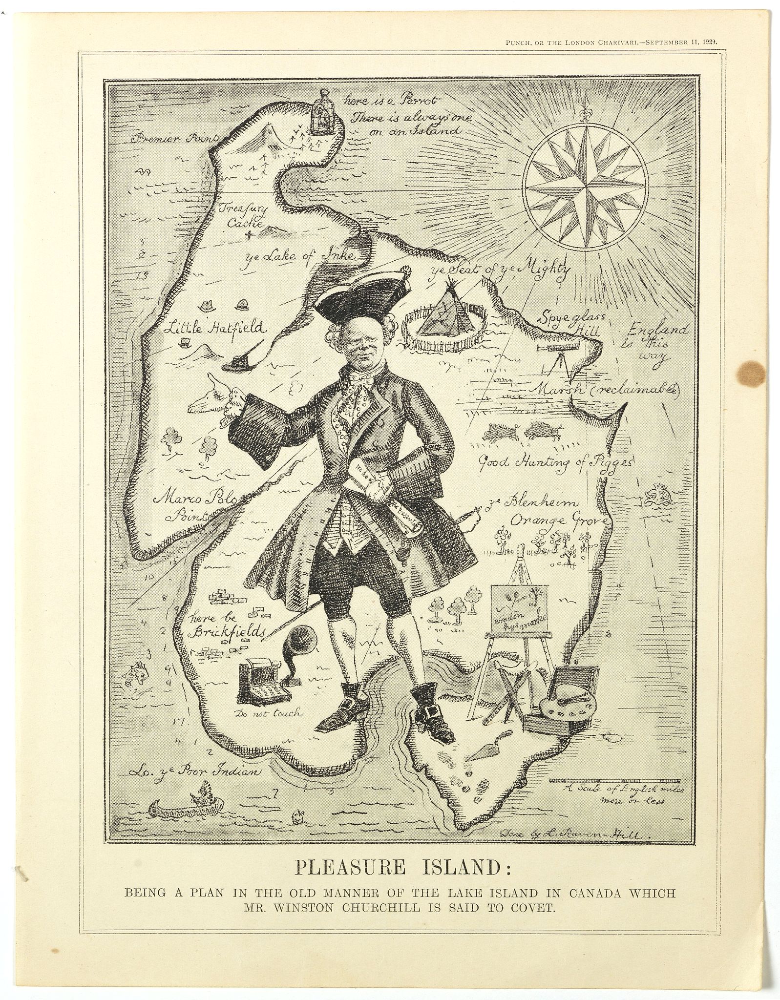
Pleasure Island : Being A Plan in the Old Manner of the Lake Island in Canada which Mr Winston Churchill is said to covert. |
||||||||||||||||||||
|
||||||||||||||||||||
|
|
||||||||||||||||||||
|
Selling price: $...
Please login to see price! Sold in 2019 Missed this item! Be the first to get notified about our newly added listings. Add your name to our mailing list. Feel free to contact us if you have a question about this item. |
Virtual Collection - Save and collect this or any of your favorite items in one place.
If you want to save the items permanently, please sign in or create account first. |
|||||||||||||||||||
Description
From Punch, September 11th, 1929.
A satirical map attacking Churchill in his "Wilderness Years." In May of 1929, the Conservative government failed to gain reelection, and Churchill lost his position as Chancellor of the Exchequer. Despite his extensive political experience and oratorical skills, the 54-year-old Churchill was unpopular within his own party because he supported free trade and Irish Home Rule. In early August, Churchill left England for a three-month tour of Canada and the United States to build up the North American readership for his books and articles, meet with important political and financial leaders, and search for good investments! Lough, 180-86. Bernard Baruch helped plan the trip, and Churchill's hosts included William Randolph Hearst, Paul Mellon, Samuel McClure, and Charles Schwab of Bethlehem Steel. Ibid.
During the lengthy Canadian leg of his trip, Churchill and his party spent August 19 at Lake of the Woods, Ontario, a lake over 70 miles long with literally thousands of islands, many occupied by luxurious vacation homes. After an exciting motorboat ride and a leisurely lunch at his host's "palatial" home, Churchill announced that he intended to buy one of the islands and make it into "a most beautiful summer residence." "Winston or one of the party with him told the newspapers of this intention to purchase an island, and it was duly reported in the Canadian papers." Tolppanen 77.
The Canadian press reports of the exiled Churchill seeking a remote Canadian retreat apparently proved too much for Punch to resist, and the map appeared three weeks later. It features a giant figure of Churchill astride an island out of traditional pirate-treasure fiction. The geographic points on the island include some references to Churchill's life and career: Blenheim (the ancestral home of the Marlboroughs, where he was born); Hatfield (where he participated in the secret development of the tank in 1916); a typewriter (labeled "do not touch"); an easel and paints; "Treasure Cache;" and at the farthest end of the island, "Premier Point. (Text by P.J. Mode)"
More aboutcartographical curiosities [+]
Reference: Persuasive Maps, PJ Mode Collection, 1229.01.
FAQ - Guarantee - Shipping
Buying in the BuyNow Gallery
This item is available for immediate purchase when a "Add to Cart" or "Inquire Now" button is shown.
Items are sold in the EU margin scheme
Payments are accepted in Euros or US Dollars.
Authenticity Guarantee
 We provide professional descriptions, condition report (based on 45 years experience in the map business)
Paulus Swaen warrants the authenticity of our items and a certificate of authenticity is provided for each acquired lot.
Condition and Coloring
We indicate the condition of each item and use our unnique HiBCoR grading system in which four key items determine a map's value: Historical Importance, Beauty, Condition/Coloring and Rarity.
Color Key
We offer many maps in their original black and white condition. We do not systematically color-up maps to make them more sellable to the general public or buyer.
Copper engraved or wood block maps are always hand colored. Maps were initially colored for aesthetic reasons and to improve readability. Nowadays, it is becoming a challenge to find maps in their original colors and are therefor more valuable.
We use the following color keys in our catalog:
Original colors; mean that the colors have been applied around the time the map was issued.
Original o/l colors; means the map has only the borders colored at the time of publication.
Colored; If the colors are applied recently or at the end of the 20th century.
Read more about coloring of maps [+]
Shipping fee
A flat shipping fee of $ 30 is added to each shipment by DHL within Europe and North America. This covers : International Priority shipping, Packing and Insurance (up to the invoice amount).
Shipments to Asia are $ 40 and rest of the world $50
We charge only one shipping fee when you have been successful on multiple items or when you want to combine gallery and auction purchases.
Read more about invoicing and shipping
FAQ
Please have a look for more information about buying in the BuyNow gallery
Many answers are likely to find in the general help section.
Virtual Collection
![]()
With Virtual Collection you can collect all your favorite items in one place. It is free, and anyone can create his or her Virtual map collection.
Unless you are logged in, the item is only saved for this session. You have to be registed and logged-in if you want to save this item permanently to your Virtual Collection.
Read More[+]
Register here, it is free and you do not need a credit card.
Add this item to
Virtual Collection
or click the following link to see my Virtual Collection.
| Digital Image Download | |
|
Paulus Swaen maintains an archive of most of our high-resolution rare maps, prints, posters and medieval manuscript scans. We make them freely available for download and study. Read more about free image download |
Click the image for a free small image download. |
In accordance with the EU Consumer Rights Directive and habitually reside in the European Union you have the right to cancel the contract for the purchase of a lot, without giving any reason.
The cancellation period will expire 14 calendar days from the day after the date on which you or a third party (other than the carrier and indicated by you) acquires, physical possession of the lot. To exercise the right to cancel you must inform Paulus Swaen Inc, of your decision to cancel this contract by a clear statement (e.g. a letter sent by post, or e-mail (amsterdam@swaen.com).
To meet the cancellation deadline, it is sufficient for you to send your communication concerning your exercise of the right to cancel before the cancellation period has expired.

