Please login to see price!.
Subscribe to be notified if similar examples become available.
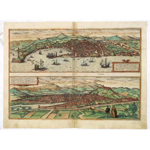
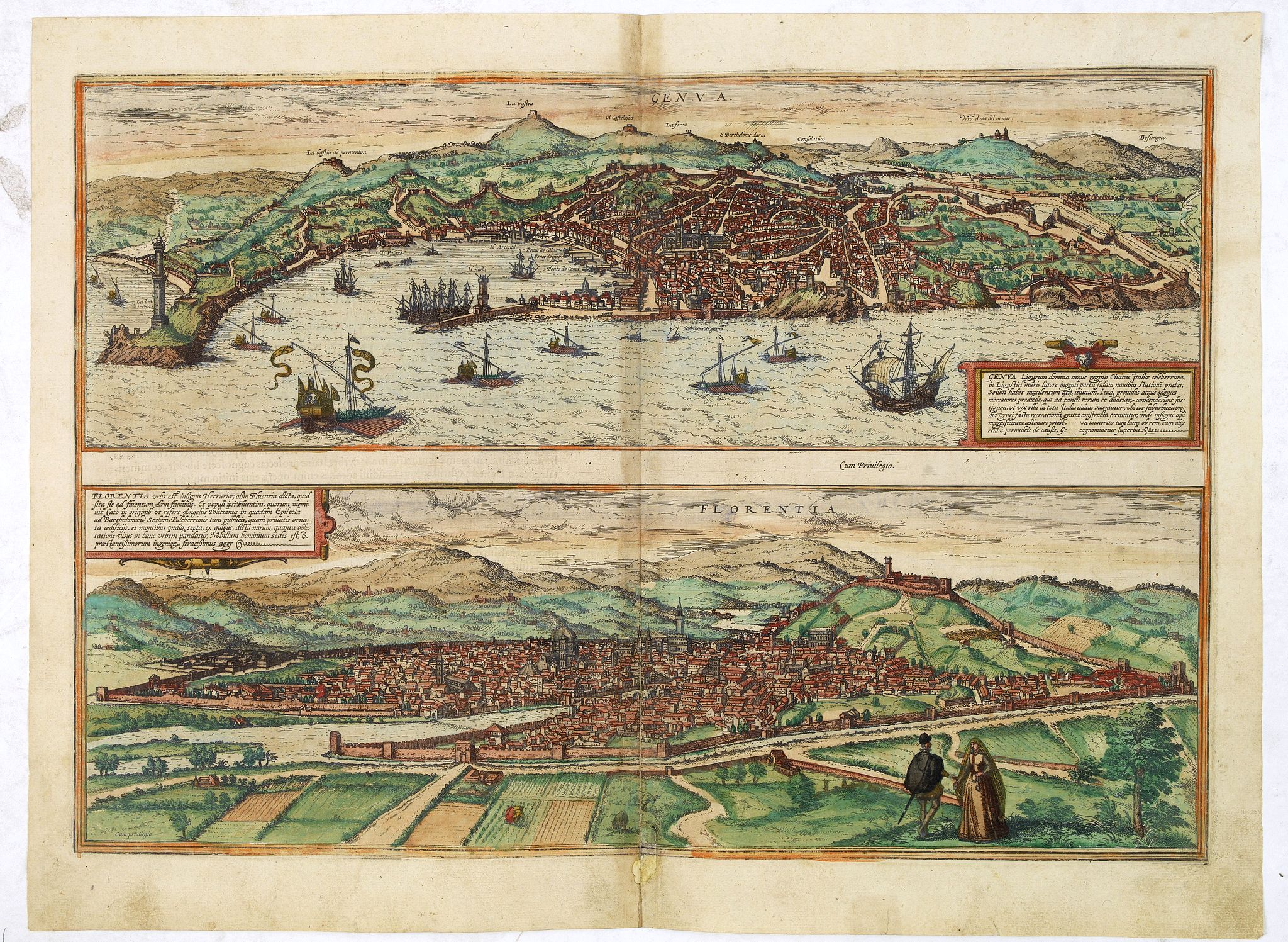
Genua Ligurum Domina [on sheet with] Florentia Urbs est Insignis Hetruariae, olim Fluentia Dicta. |
||||||||||||||||||||
|
||||||||||||||||||||
|
|
||||||||||||||||||||
|
Selling price: $...
Please login to see price! Sold in 2017 Missed this item! Be the first to get notified about our newly added listings. Add your name to our mailing list. Feel free to contact us if you have a question about this item. |
Collection - Save and collect this or any of your favorite items in one place.
If you want to save the items permanently, please sign in or create account first. |
|||||||||||||||||||
Description
Two very desirable and early town-views of Genoa and Florence in a second state.
"GENOA (GENOVA): : "The trading port and city of Genoa is presented from an ideal, elevated viewpoint from the south. The layout of the city can be clearly seen as it slopes down to the sea. In the center stands the Romanesque cathedral of San Lorenzo, built in the 13th century. Higher up the hillside lies the Palazzo Ducale. The approximately 80-m-high lighthouse (La Lanterna) on the left is another symbol of the city. Genoa's economic importance is underlined by the volume of shipping in front of the port. 1407 saw the founding in Genoa of the Banco di San Giorgio, which lent money to various monarchs in the early modern era and thereby earned Genoa a critical position within the network of Europe's ruling houses.. . ." (Taschen, Braun, and Hogenberg, p.112.)
FLORENCE (FIRENZE): "The engraving shows Florence from the southwest. On the far side of the Arno, the cathedral of Santa Maria del Fiore with its impressive cupola (1418-1436) by Filippo Brunelleschi soars above the roofs of the densely packed houses. Visible in front of it are the bell tower, built from 1330 to designs by Giotto, and the Baptistery (11th-12th cent.) with its magnificent bronze doors by Andrea Pisano and Lorenzo Ghiberti (1330-1452). Behind it to the right, as a symbol of secular power, is the Palazzo della Signoria (14th cent.), today, it is known as the Palazzo Vecchio, with its 94-m-high tower. Florence was founded as a Roman colony in Caesar's day when it marked two major trade routes. In the 14th and 15th centuries, it developed into a city of art and culture, attracting many artists and intellectuals, including Sandro Botticelli, Galileo Gallilei, Leonardo da Vinci and Niccolo Machiavelli. Under the rule of the Medici family, Florence also developed into an important center of finance and trade. With a population of around 366,000, Florence is today the capital of Tuscany." . (Taschen, Braun, and Hogenberg, p.112.)
From volume one of the greatest publication in this genre!. The Civitates was compiled and written by George Braun, Canon of Cologne Cathedral. Braun gathered vast amounts of information and draft plans to produce over 500 city views/maps published in six parts between 1572 and 1617. Most of these engravings were made by Simon Novellanus and Frans Hogenberg, many after drawings by Joris Hoefnagel.
Read more about the Civitates Orbis.
Reference: Koeman (1967-70) B & H 1-5, NMM III, i, 459 (1573-1618 ed.), Introduction', in: G. Braun and F. Hogenberg, Civitates orbis terrarum (Amsterdam: 1965). (2)
FAQ - Guarantee - Shipping
Buying in the BuyNow Gallery
This item is available for immediate purchase when a "Add to Cart" or "Inquire Now" button is shown.
Items are sold in the EU margin scheme
Payments are accepted in Euros or US Dollars.
Authenticity Guarantee
 We provide professional descriptions, condition report (based on 45 years experience in the map business)
Paulus Swaen warrants the authenticity of our items and a certificate of authenticity is provided for each acquired lot.
Condition and Coloring
We indicate the condition of each item and use our unnique HiBCoR grading system in which four key items determine a map's value: Historical Importance, Beauty, Condition/Coloring and Rarity.
Color Key
We offer many maps in their original black and white condition. We do not systematically color-up maps to make them more sellable to the general public or buyer.
Copper engraved or wood block maps are always hand colored. Maps were initially colored for aesthetic reasons and to improve readability. Nowadays, it is becoming a challenge to find maps in their original colors and are therefor more valuable.
We use the following color keys in our catalog:
Original colors; mean that the colors have been applied around the time the map was issued.
Original o/l colors; means the map has only the borders colored at the time of publication.
Colored; If the colors are applied recently or at the end of the 20th century.
Read more about coloring of maps [+]
Shipping fee
A flat shipping fee of $ 30 is added to each shipment by DHL within Europe and North America. This covers : International Priority shipping, Packing and Insurance (up to the invoice amount).
Shipments to Asia are $ 40 and rest of the world $50
We charge only one shipping fee when you have been successful on multiple items or when you want to combine gallery and auction purchases.
Read more about invoicing and shipping
FAQ
Please have a look for more information about buying in the BuyNow gallery
Many answers are likely to find in the general help section.
Collection
![]()
With Collection you can collect all your favorite items in one place. It is free, and anyone can create his or her Virtual map collection.
Unless you are logged in, the item is only saved for this session. You have to be registed and logged-in if you want to save this item permanently to your Virtual Collection.
Read More[+]
Register here, it is free and you do not need a credit card.
Add this item to
Virtual Collection
or click the following link to see my Collection.
| Digital Image Download | |
|
Paulus Swaen maintains an archive of most of our high-resolution rare maps, prints, posters and medieval manuscript scans. We make them freely available for download and study. Read more about free image download |
Click the image for a free small image download. |
![Rare, antique map of Genua Ligurum Domina [on sheet with] Florentia Urbs est Insignis Hetruariae, olim Fluentia Dicta.](/uploads/33676.jpg)
In accordance with the EU Consumer Rights Directive and habitually reside in the European Union you have the right to cancel the contract for the purchase of a lot, without giving any reason.
The cancellation period will expire 14 calendar days from the day after the date on which you or a third party (other than the carrier and indicated by you) acquires, physical possession of the lot. To exercise the right to cancel you must inform Paulus Swaen Inc, of your decision to cancel this contract by a clear statement (e.g. a letter sent by post, or e-mail (amsterdam@swaen.com).
To meet the cancellation deadline, it is sufficient for you to send your communication concerning your exercise of the right to cancel before the cancellation period has expired.
