Subscribe to be notified if similar examples become available.
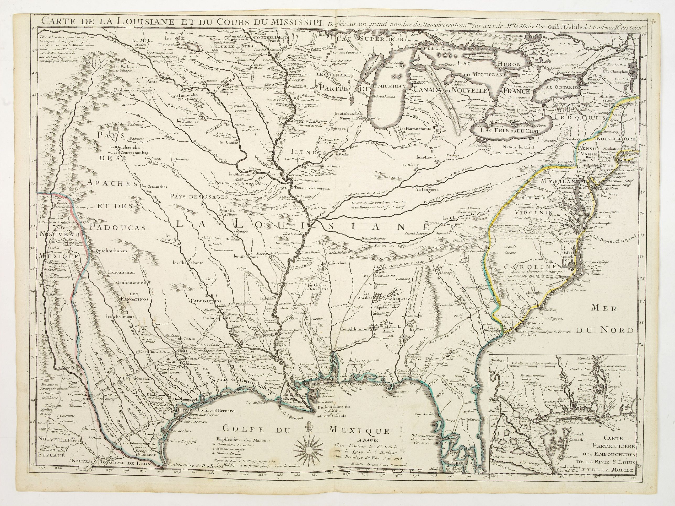
Carte de la Louisiane et du cours du Mississipi. |
||||||||||||||||||||
|
||||||||||||||||||||
|
|
||||||||||||||||||||
|
Selling price: $ Please login to see price!
Sold Missed this item! Add your name to our mailing list and be the first to get notified about our newly added listings. . |
My Collection +
Add this or any of your favorite items in one place. If you want to save the items permanently, you have to sign in or create an account first. |
|||||||||||||||||||
Description
First issue, first state (New Orleans not yet located) of “the first detailed map of the Gulf region and the Mississippi, [and] the first printed map to show Texas”(Tooley, French Mapping of the Americas #43). This map is also known for its detailed depiction of the states adjacent to the Gulf of Mexico region, the Mississippi River and the land routes of many of the explorers of previous centuries.
On the map, De L'Isle made assertions that Carolina was a possession of the French. Shows Indian villages, "nations derangees, nations detruites," the route of de Soto, Moscoso, Cavelier, Tonty and Denis, etc. Relief shown pictorially.
Inset map: Carte particuliere des embouchures de la Rivie. S. Louis et de la Mobile, i.e., Mississippi Delta area and Mobile Bay.
Kohl 238: “This map is the mother and main source of all the later maps of the Mississippi.” Lemmon, et al, Charting Louisiana, Plate 18, p. 58: “Guillaume de L’Isle’s 1718 map is politically, geographically, and historically one of the most important maps of the Mississippi Valley. Repeatedly copied and widely referenced, it was the chief authority for the Mississippi river for more than fifty years.” Lowery 288: “Earliest map by Delisle showing De Soto’s route.” Luebke, Mapping the North American Plains, p. 10 (Ehrenberg): “Carte de la Louisiane et du Cours du Missisipi included a more accurate rendition of the lower Missouri and the Osage rivers, the introduction of the Kansas and Platte rivers, and the extension of an elongated Red River.... In addition the French belief that one could reach New Spain by traveling up the Missouri...was supported by the Delisles, who depicted the headwaters of the Missouri in close proximity to those of the Rio Grande and a chain of mountains paralleling the Rio Grande.”
See also Andrew M. Balash, “How Maps Tell the Truth by Lying: An Analysis of Delisle’s 1718 Carte de la Louisiane” (University of Texas at Arlington, December 2008)
"Maps do more than simply record geographical locations. Maps graphically display information that is at once geographic, economic, political, social, scientific, and religious. Through careful analysis, including the conscious and subconscious selections of map-makers, maps reveal a perception of the world.
This is the subjective vision of the world buried beneath the seemingly ‘objective’ façade of the map—the hidden story that the cartographers did not even know they were telling. Such an analysis applied to Guillaume Delisle’s 1718 "Carte de la Louisiane et du Cours du Mississipi", which not only reveals the state of French geographic knowledge about the North American continent, but also reflects political, social, and economic aspirations as well as a culture in transition from a Catholicized classical Greek view of the world and humans’ place in it to a view of the world through the emerging eyes of science in the service of the state."
Reference: Cumming, 170., Tooley, Mapping of America, 43., Wheat, 99., Paullin and Wright, 24; Martin, 19, etc.
FAQ - Guarantee - Shipping
Buying in the BuyNow Gallery
This item is available for immediate purchase when a "Add to Cart" or "Inquire Now" button is shown.
Items are sold in the EU margin scheme
Payments are accepted in Euros or US Dollars.
Authenticity Guarantee
 We provide professional descriptions, condition report (based on 45 years experience in the map business)
Paulus Swaen warrants the authenticity of our items and a certificate of authenticity is provided for each acquired lot.
Condition and Coloring
We indicate the condition of each item and use our unnique HiBCoR grading system in which four key items determine a map's value: Historical Importance, Beauty, Condition/Coloring and Rarity.
Color Key
We offer many maps in their original black and white condition. We do not systematically color-up maps to make them more sellable to the general public or buyer.
Copper engraved or wood block maps are always hand colored. Maps were initially colored for aesthetic reasons and to improve readability. Nowadays, it is becoming a challenge to find maps in their original colors and are therefor more valuable.
We use the following color keys in our catalog:
Original colors; mean that the colors have been applied around the time the map was issued.
Original o/l colors; means the map has only the borders colored at the time of publication.
Colored; If the colors are applied recently or at the end of the 20th century.
Read more about coloring of maps [+]
Shipping fee
A flat shipping fee of $ 30 is added to each shipment by DHL within Europe and North America. This covers : International Priority shipping, Packing and Insurance (up to the invoice amount).
Shipments to Asia are $ 40 and rest of the world $50
We charge only one shipping fee when you have been successful on multiple items or when you want to combine gallery and auction purchases.
Read more about invoicing and shipping
FAQ
Please have a look for more information about buying in the BuyNow gallery
Many answers are likely to find in the general help section.
My Collection+
![]()
With My Collection+ you can collect all your favorite items in one place. It is free, and anyone can create his or her virtual collection.
Unless you are logged in, the item is only saved for this session. You have to be registed and logged-in if you want to save this item permanently to My Collection+.
Read More[+]
Register here, it is free and you do not need a credit card.
Add this item to
My Collection+
or click the following link to see My Collection+.
| Digital Image Download | |
|
Paulus Swaen maintains an archive of most of our high-resolution rare maps, prints, posters and medieval manuscript scans. We make them freely available for download and study. Read more about free image download |
Click the image for a free small image download. |
In accordance with the EU Consumer Rights Directive and habitually reside in the European Union you have the right to cancel the contract for the purchase of a lot, without giving any reason.
The cancellation period will expire 14 calendar days from the day after the date on which you or a third party (other than the carrier and indicated by you) acquires, physical possession of the lot. To exercise the right to cancel you must inform Paulus Swaen Inc, of your decision to cancel this contract by a clear statement (e.g. a letter sent by post, or e-mail.
To meet the cancellation deadline, it is sufficient for you to send your communication concerning your exercise of the right to cancel before the cancellation period has expired.
