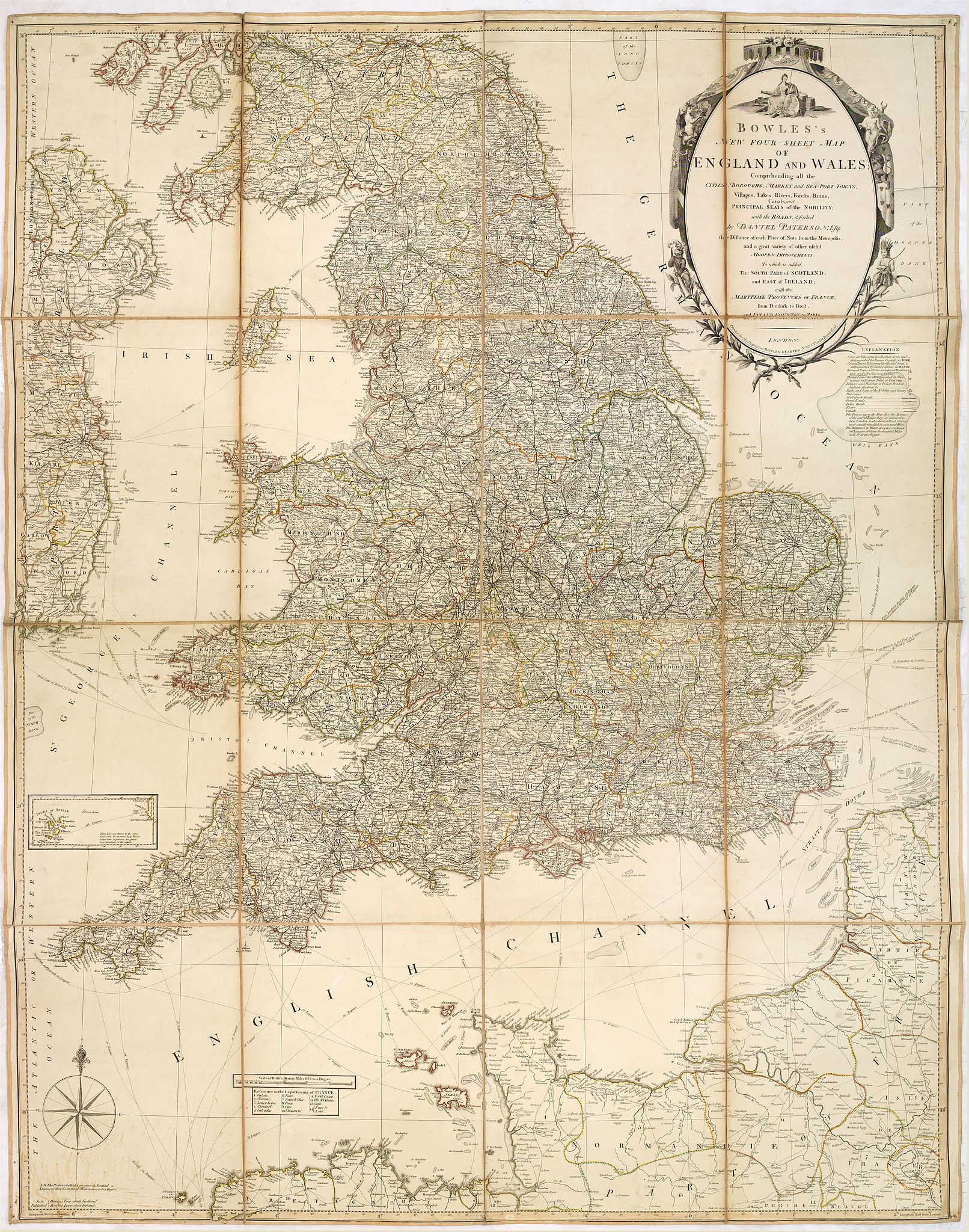
1801 BOWLES, C. / CARVER - Bowles's new four-sheet map of England and Wales. . .
Bowles's new four-sheet map of England and Wales. . . |
||||||||||||||||||||
|
||||||||||||||||||||
|
|
||||||||||||||||||||
$600 / ≈ €535
This item is available for immediate sale
|
My Collection +
Add this or any of your favorite items in one place. If you want to save the items permanently, you have to sign in or create an account first.   Add/Remove
 |
|||||||||||||||||||



Description
Bowles's new four-sheet map of England and Wales: Comprehending all the Cities, Boroughs, Market and Sea-Port Towns, Villages, Lakes, Rivers, Forests, Ruins, Canals, and Principal Seats of the Nobility, with the Roads ... To which is added The South Part of Scotland, and East of Ireland, with the Maritime Provinces of France from Dunkirk to Brest ... Bowles & Carver Published as the act directs 2 Jan.1801.
Folding maps
Most published maps first appeared in books, atlases, travel or history books, or guidebooks. Those maps not issued in such volumes may have been published as loose sheets, as wall maps, or as folding maps. Usually, these folding maps are dissected, laid on linen and folded within binders or a slip-case. In any of these cases, the vulnerability of the map on paper is obvious.One of the great inconveniences of the standard folio-size atlas was, obviously, its lack of portability. Over the years, this problem was solved in two ways: the development of the so-called "pocket atlas," or Pocketbook map, or folding map.
The folding map was often a single map, often dissected, mounted on linen or extra-thick paper, and bound into a protective folder or loose in a slip-case. It is not uncommon to find maps taken from atlases, then mounted and folded, for practical use during a voyage. Obviously, the more interesting maps of this genre were those specifically issued separately. These maps, often at a much larger scale than those in atlases, were intended for practical use and, accordingly, are not always in the best condition.
The nineteenth-century interest in travel - the birth of commercial tourism, which we now take for granted - spawned a dramatic increase in town plans and guides of major cities or resort areas.
Pocket maps relating to the New World can be found, either for those who already lived there or as guides for the great numbers of emigrants who sailed west to North America.
Folding maps have, to an extent, been overlooked by collectors in the past, since they do not conveniently fit into a folder or drawer of flat maps, and are not usually of sufficient decorative quality to be framed and hung.
Accordingly, a wide range of interesting maps is available, and although rarities fetch high prices, many can be found at a reasonable cost. (See Country Life Book of Antique maps, by J.Potter, Mappamundi.)
FAQ - Guarantee - Shipping
This item is available for immediate purchase when a "Add to Cart" or "Inquire Now" button is shown.
Items are sold in the EU margin scheme
Payments are accepted in Euros or US Dollars.
Authenticity Guarantee
 We provide professional descriptions, condition report (based on 45 years experience in the map business)
Paulus Swaen warrants the authenticity of our items and a certificate of authenticity is provided for each acquired lot.
Condition and Coloring
We indicate the condition of each item and use our unnique HiBCoR grading system in which four key items determine a map's value: Historical Importance, Beauty, Condition/Coloring and Rarity.
Color Key
We offer many maps in their original black and white condition. We do not systematically color-up maps to make them more sellable to the general public or buyer.
Copper engraved or wood block maps are always hand colored. Maps were initially colored for aesthetic reasons and to improve readability. Nowadays, it is becoming a challenge to find maps in their original colors and are therefor more valuable.
We use the following color keys in our catalog:
Original colors; mean that the colors have been applied around the time the map was issued.
Original o/l colors; means the map has only the borders colored at the time of publication.
Colored; If the colors are applied recently or at the end of the 20th century.
Read more about coloring of maps [+]
Shipping fee
A flat shipping fee of $ 30 is added to each shipment by DHL within Europe and North America. This covers : International Priority shipping, Packing and Insurance (up to the invoice amount).
Shipments to Asia are $ 40 and rest of the world $50
We charge only one shipping fee when you have been successful on multiple items or when you want to combine gallery and auction purchases.
Read more about invoicing and shipping
FAQ
Please have a look for more information about buying in the BuyNow gallery
Many answers are likely to find in the general help section.
My Collection+

With My Collection+ you can collect all your favorite items in one place. It is free, and anyone can create his or her virtual collection.
Unless you are logged in, the item is only saved for this session. You have to be registed and logged-in if you want to save this item permanently to My Collection+. Read More[+]
Register here, it is free and you do not need a credit card.
Add this item to My Collection+ or click the following link to see My Collection+.
|
Digital Image Download Paulus Swaen maintains an archive of most of our high-resolution rare maps, prints, posters and medieval manuscript scans. We make them freely available for download and study. Read more about free image download |
Click the image for a free small image download. |
YOUR RIGHT TO CANCEL THE PURCHASE OF A LOT
In accordance with the EU Consumer Rights Directive and habitually reside in the European Union you have the right to cancel the contract for the purchase of a lot, without giving any reason.
The cancellation period will expire 14 calendar days from the day after the date on which you or a third party (other than the carrier and indicated by you) acquires, physical possession of the lot. To exercise the right to cancel you must inform Paulus Swaen Inc, of your decision to cancel this contract by a clear statement (e.g. a letter sent by post, or e-mail.
To meet the cancellation deadline, it is sufficient for you to send your communication concerning your exercise of the right to cancel before the cancellation period has expired.
