Browse Listings
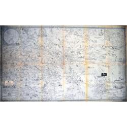
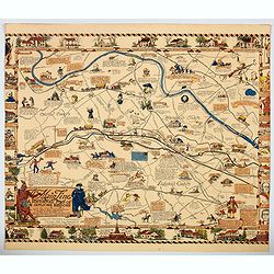
Isfahan and Shehreza Shehrekurd Faridan Nadjaf Abad Nain_Khonsar Bakhtiyari summer and winter quarters and part of Khouzestan Golpayegan Kashan in detail.
A very unusual large scale map of Isfahan, partially with Persian writing! Published by the Sahab Geographical & Drafting Institute, Teheran, probably between 1960 an...
Date: Teheran, c1965
Selling price: ????
Please login to see price!
Sold in 2014
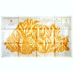
The Kingdom of Bhutan.
Unusual wall map sized map of Bhutan, prepared by Pradyumna P. Karan and published by the University of Kentucky. The map is showing international boundaries, transportat...
Date: Kentucky, 1965
Selling price: ????
Please login to see price!
Sold in 2016
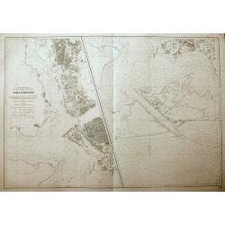
Port d'Abidjan.
An unusual sea-chart of Abidjan, Côte d'Ivoire. With excellent detail of the coasts, and the city. The left chart shows the harbour, and the chart on the right shows the...
Date: Paris, 1965
Selling price: ????
Please login to see price!
Sold in 2018
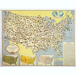
Carte Illustree des Etats-Unis d'Amerique Principaux produits, resources regionales, et particularites physiques.
A decorative French map of the United States' main products, regional resources and physical features. The map is covered with many small pictorial vignettes highlighting...
Date: Washington D.C., ca. 1965
Selling price: ????
Please login to see price!
Sold in 2018

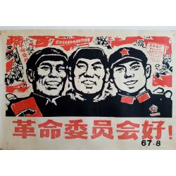
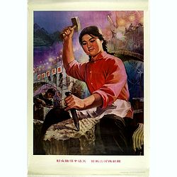
Chinese Poster.
A young nurse in the countryside.More about Chinese propaganda posters [+]
Date: China, 1965
Selling price: ????
Please login to see price!
Sold in 2019
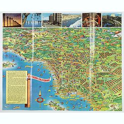
A Pic-Tour map of Southern California.
A highly colorful and attractive pictorial travel map of southern California, from Santa Barbara, southward to San Diego & Tijuana. Major streets, highways, attractio...
Date: San Francisco, ca 1965
Selling price: ????
Please login to see price!
Sold in 2019
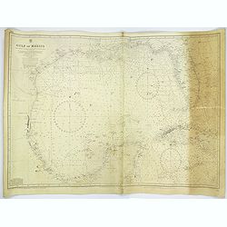
Gulf of Mexico.
A large sea chart of the Gulf of Mexico 'from Admiralty Charts and US Government charts, corrected to 1966'. (In fact there are corrections up until 1977).Chart extent is...
Date: London, 1882 corrected to 1966
Selling price: ????
Please login to see price!
Sold in 2017
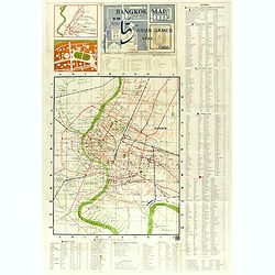
Bangkok Map in the 5th Asian Games year 1966.
A rare early map (460 x 370mm.) for the Siamese capital, shows the roads in red, railroads in blue and waterways, as well as points of interest. An exhaustive key notes t...
Date: Bangkok, 1966
Selling price: ????
Please login to see price!
Sold in 2018
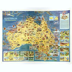
Australia, The Awakening Giant.
A large, fully colored map of Australia.
Date: Victoria, 1967
Selling price: ????
Please login to see price!
Sold in 2018
Propaganda Chinese Poster.
The Cultural Revolutionary Guards. More about Chinese propaganda posters [+]
Date: China, 1967
Selling price: ????
Please login to see price!
Sold in 2021
![[Air France set of 14 publicity posters with brochure and folder. ]](/uploads/cache/44384-250x250.jpg)
[Air France set of 14 publicity posters with brochure and folder. ]
Complete set of 14 posters, kept in its original card board case and with the informative brochure in German language. The brochure (360x210mm) has a title "15 Plaka...
Date: Paris, Draeger, 1967
Selling price: ????
Please login to see price!
Sold in 2019
![[Russian map of southern USA, Mexico, West Indies & Central America].](/uploads/cache/44785-250x250.jpg)
[Russian map of southern USA, Mexico, West Indies & Central America].
An unusual Russian map of the south of the United States, western Mexico, the Caribbean, Central America, and the northern tip of South America. Fully colored, with three...
Date: Moscow, 1967
Selling price: ????
Please login to see price!
Sold in 2019
USSR.
A proof state of the rare USSR Air France poster created by Georges Mathieu. In the initial series of 15 posters, the USSR was forgotten and has been published separately...
Date: Paris, 1967
Selling price: ????
Please login to see price!
Sold in 2021
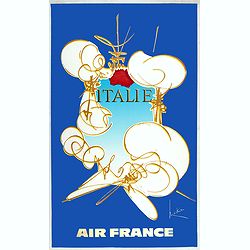
Italy.
Decorative poster advertising flights to Italy for AirFrance made by Georges Mathieu. The poster is one of a series of 15 composed of posters of Greece, Israel, Germany, ...
Date: Paris, 1967
Selling price: ????
Please login to see price!
Sold in 2023
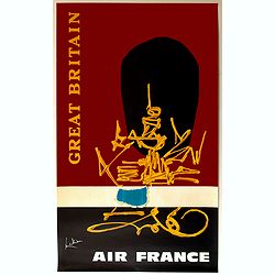
Great Brittain.
Decorative poster advertising flights to Great Britain made by Georges Mathieu. The poster is one of a series of 15 composed of posters of Greece, Israel, Germany, Great ...
Date: Paris, 1967
Selling price: ????
Please login to see price!
Sold in 2020
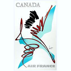
Canada.
Decorative poster advertising flights to Canada made by Georges Mathieu. The poster is one of a series of 15 composed of posters of Greece, Israel, Germany, Great Britain...
Date: Paris, 1967
Selling price: ????
Please login to see price!
Sold in 2023
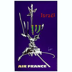
Israel
Decorative poster advertising flights to Israel made by Georges Mathieu. The poster is one of a series of 15 composed of posters of Greece, Israel, Germany, Great Britain...
Date: Paris, 1967
Selling price: ????
Please login to see price!
Sold in 2023
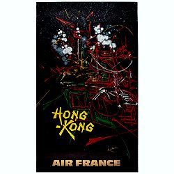
Hong Kong.
Decorative poster advertising flights to Hong Kong made by Georges Mathieu. The poster is published outside his series of 15 composed of posters of Greece, Israel, German...
Date: Paris, 1967
Selling price: ????
Please login to see price!
Sold in 2021
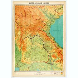
Carte générale du Laos.
General map of Laos published in 1968 by the "Service Géographique National du Laos", showing international and province boundaries, transportation, water feat...
Date: [Vientiane] , 1968
Selling price: ????
Please login to see price!
Sold in 2020
![[ Facsimile] BLAEU, J. - Le grand atlas ou cosmographie Blauiana. (Atlas major).](/uploads/cache/16987-250x250.jpg)
[ Facsimile] BLAEU, J. - Le grand atlas ou cosmographie Blauiana. (Atlas major).
Facsimile of the original French edition of Joan Blaeu's Atlas Major, 1663. Printed in Amsterdam, by N.V. Theatrum Orbis Terrarum, 1967-68.12 volumes with 609 double-pag...
Date: Amsterdam 1968
Selling price: ????
Please login to see price!
Sold in 2008
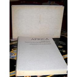
Africa on maps dating from the twelfth to the eighteenth century. Africa auf Karten des 12. bis 18. Jahrhunderts.
First edition. Cloth over Boards. First edition. Elephant folio. The book contains Seventy-seven reproductions of maps of Africa from European map collections, with maps ...
Date: Leipzig, 1968
Selling price: ????
Please login to see price!
Sold in 2017
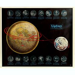
LIPTON Lunar Space Map
Promotional map of the expedition of the Apollo astronauts to make the July 20, 1969 lunar landing, illustrated by George J. Zaffo, produced for Lipton's Tea.Showing deta...
Date: Thomas J. Lipton, Inc., ca. 1969
Selling price: ????
Please login to see price!
Sold in 2019

(Chairman Mao is the Red Sun in Our Hearts)
Chairman Mao guiding all the people from every country to great happiness.Read more about Chinese propaganda posters [+]
Date: China, 1969
Selling price: ????
Please login to see price!
Sold in 2019
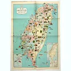
Tourist's map of Taiwan fuel station products scenic spots.
color pictorial tourist's map of Taiwan, in Chinese and English. Shows administrative divisions, cities, towns, capitals, gas stations, agricultural Products, industry, t...
Date: Minguo calendar 58 - 1969
Selling price: ????
Please login to see price!
Sold in 2019

Theatrum Orbis Facsimile of Coronelli GoresCoronelli, Libro Libro Dei Globi, Venice 1693 (1701)
From the "Theatrum Orbis Terrarum Series of Facsimile Atlases, 1969. A scarce book. The facsimile of Coronelli's Libro Dei Globi of 1693 (1701) is part of the four...
Date: Chicago & London, 1969
Selling price: ????
Please login to see price!
Sold in 2013

Africa On Maps Dating From The Twelfth To The Eighteenth Century.
A fine copy of this important work showing and describing antique maps of Africa dating from the twelfth to the eighteenth century by the leading German authority on anti...
Date: New York: MacGraw Hill, 1970
Selling price: ????
Please login to see price!
Sold in 2014
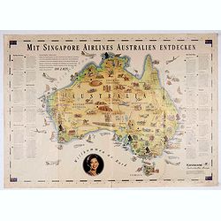
Mit Singapore Airlines Autralien Entdecken.
Map of Australia for Karawane travel agency in Ludwigsburg, Germany from Singapore. Map with animals, leisure facilities, places of interest and locations of Singapore Ai...
Date: Ludwigsburg, ca. 1970
Selling price: ????
Please login to see price!
Sold in 2020
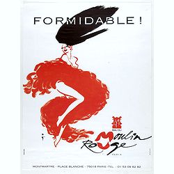
FORMIDABLE ! Bal Du Moulin Rouge.
Design by René Gruau for Moulin Rouge. René Gruau (1909-2004) was a Franco-Italian artist. He enjoyed real success after World War II working as a fashion illustrator f...
Date: Paris, ca. 1970
Selling price: ????
Please login to see price!
Sold in 2021
![[Anti capitalism Soviet Union propaganda poster]](/uploads/cache/47038-250x250.jpg)
[Anti capitalism Soviet Union propaganda poster]
Propaganda mini anti-capitalism poster published in Russia during The Cold War. By the 1960’s and 1970’s, outrageous practices in Soviet bureaucracy flourished. Poor ...
Date: Leningrad, 1970
Selling price: ????
Please login to see price!
Sold in 2024

County Atlases Of The British Isles 1579-1703.
A most informative reference book. Cloth bound with dust jacket 250 pages plus illustrations and figures. The definitive carto-bibliography. Published in 1970 by Carta Pr...
Date: London, 1970
Selling price: ????
Please login to see price!
Sold in 2017

Chinese propaganda poster.
We Shall Liberate Taiwan!, by the Hongyingbi (Red Eagle Brush) unit of the Air Force Unit of Nanjing Military Region.The Chinese did try to spread the words of Mao on Tai...
Date: China, 1971
Selling price: ????
Please login to see price!
Sold in 2019
![[Anti capitalism Soviet Union propaganda poster]](/uploads/cache/47026-250x250.jpg)
[Anti capitalism Soviet Union propaganda poster]
Propaganda mini anti-capitalism poster published in Russia during The Cold War. By the 1960’s and 1970’s, outrageous practices in Soviet bureaucracy flourished. Poor ...
Date: Leningrad, 1971
Selling price: ????
Please login to see price!
Sold in 2022
![[Anti capitalism Soviet Union propaganda poster]](/uploads/cache/47027-250x250.jpg)
[Anti capitalism Soviet Union propaganda poster]
Propaganda mini anti-capitalism poster published in Russia during The Cold War. By the 1960’s and 1970’s, outrageous practices in Soviet bureaucracy flourished. Poor ...
Date: Leningrad, 1971
Selling price: ????
Please login to see price!
Sold in 2022
![[Anti capitalism Soviet Union propaganda poster]](/uploads/cache/47030-250x250.jpg)
[Anti capitalism Soviet Union propaganda poster]
Propaganda mini anti-capitalism poster published in Russia during The Cold War. By the 1960’s and 1970’s, outrageous practices in Soviet bureaucracy flourished. Poor ...
Date: Leningrad, 1971
Selling price: ????
Please login to see price!
Sold in 2021

Miro, Peintures sur Papiers / Dessins - Galerie Maeght.
An original poster produced for two successive Miró exhibitions bat the Galerie Maeght, Paris: Peintures sur Papier (15 October to 12 November 1971) and Dessins (17 Nove...
Date: Paris, 1971
Selling price: ????
Please login to see price!
Sold in 2021

Folies Bergères - J'aime à la folie. Hélène Martini.
Original advertising poster for the show "J'aime la Folie!" presented by Hélène Martini in the famous Les Folies Bergère cabaret in Paris. The Théâtre des ...
Date: Paris, 1971
Selling price: ????
Please login to see price!
Sold in 2024
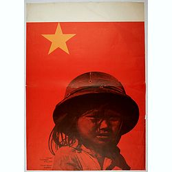
Vietnam commission of the GDR - Comité vietnam de la RDA.
East German propaganda poster of a young Vietnamese girl after a photograph by Thomas Billhardt and created by Rudolff Grüttner.In concert with the Soviet Union and Wars...
Date: ca. 1972
Selling price: ????
Please login to see price!
Sold in 2022
![[Rare tectonic globe]](/uploads/cache/82786-250x250.jpg)
[Rare tectonic globe]
This rare tectonic earth globe was one of the first globes beautifully illustrating the novel theory of plate tectonics at the time. The science of plate tectonics descri...
Date: Leipzig, 1972
Selling price: ????
Please login to see price!
Sold in 2019
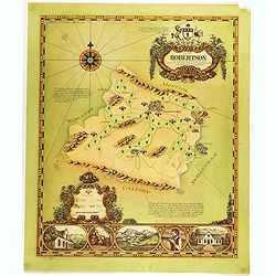
A map of Robertson area as defined for the production of wines of origins . . .
Decorative map of Robertson, a wine area in South Africa. The Cape winelands stretch from the rugged mountains and multi-directional slopes of the coastal region to the o...
Date: South Africa, 1973
Selling price: ????
Please login to see price!
Sold in 2019
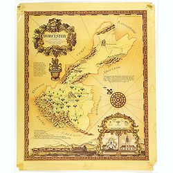
A map of the Worcester area as defined for the production of wines of origin . . .
Decorative map of Worcester, a wine area in South Africa. The Cape winelands stretch from the rugged mountains and multi-directional slopes of the coastal region to the o...
Date: South Africa, 1973
Selling price: ????
Please login to see price!
Sold in 2019
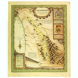
A map of the Olifantsrivier area as defined for the production of wines of origin . . .
Decorative map of Olifantsrivier, a wine area in South Africa. The Cape winelands stretch from the rugged mountains and multi-directional slopes of the coastal region to ...
Date: South Africa, 1973
Selling price: ????
Please login to see price!
Sold in 2019
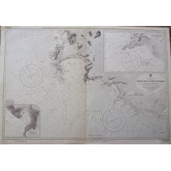
Table Bay to Cape Agulhas.
A large scale Admiralty sea-chart of Cape Town, extending until Struis Bay. With excellent detail of the coasts, including depth soundings. With two insets of Point Dange...
Date: London, 1973
Selling price: ????
Please login to see price!
Sold in 2018
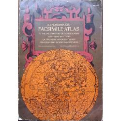
Facsimile-Atlas to the Early History of Cartography With Reproductions of the Most Important Maps Printed in the XV and XVI Centuries.
An important and useful work with 102 plates and 84 additional maps printed before 1600, including the 1400 edition of Ptolemy.This is an over-sized (tall folio), 3 pound...
Date: New York, 1973
Selling price: ????
Please login to see price!
Sold in 2020
![[Anti capitalism Soviet Union propaganda poster]](/uploads/cache/47025-250x250.jpg)
[Anti capitalism Soviet Union propaganda poster]
Propaganda mini anti-capitalism poster published in Russia during The Cold War. By the 1960’s and 1970’s, outrageous practices in Soviet bureaucracy flourished. Poor ...
Date: Leningrad, 1973
Selling price: ????
Please login to see price!
Sold in 2021
![[Anti capitalism Soviet Union propaganda poster]](/uploads/cache/47029-250x250.jpg)
[Anti capitalism Soviet Union propaganda poster]
Propaganda mini anti-capitalism poster published in Russia during The Cold War. By the 1960’s and 1970’s, outrageous practices in Soviet bureaucracy flourished. Poor ...
Date: Leningrad, 1973
Selling price: ????
Please login to see price!
Sold in 2024
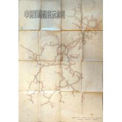
Schematic Map of Chinese Railway Routes.
A very interesting map of Chinese rail lines extending to the northernmost region of Heilongjiang and to Hainan Island in the south. Rail lines indicate the way to Urumqi...
Date: Shaanxi, 1974
Selling price: ????
Please login to see price!
Sold in 2021
![[Anti capitalism Soviet Union propaganda poster]](/uploads/cache/47031-250x250.jpg)
[Anti capitalism Soviet Union propaganda poster]
Propaganda mini anti-capitalism poster published in Russia during The Cold War. By the 1960’s and 1970’s, outrageous practices in Soviet bureaucracy flourished. Poor ...
Date: Leningrad, 1974
Selling price: ????
Please login to see price!
Sold in 2021
![[Anti capitalism Soviet Union propaganda poster]](/uploads/cache/47037-250x250.jpg)
[Anti capitalism Soviet Union propaganda poster]
Propaganda mini anti-capitalism poster published in Russia during The Cold War. By the 1960’s and 1970’s, outrageous practices in Soviet bureaucracy flourished. Poor ...
Date: Leningrad, 1974
Selling price: ????
Please login to see price!
Sold in 2021
![[Anti capitalism Soviet Union propaganda poster]](/uploads/cache/47024-250x250.jpg)
[Anti capitalism Soviet Union propaganda poster]
Propaganda mini anti-capitalism poster published in Russia during The Cold War. By the 1960’s and 1970’s, outrageous practices in Soviet bureaucracy flourished. Poor ...
Date: Leningrad, 1974
Selling price: ????
Please login to see price!
Sold in 2022
The Main Line. A Historical Map of Ye Outlying Regions . . .
A pictorial map depicting the geography, history and landmarks of the Main Line, the informal name for a group of western suburbs of Philadelphia, Pennsylvania. The area ...
Date: Philadelphia, 1975
Selling price: ????
Please login to see price!
Sold in 2020
![[Anti capitalism Soviet Union propaganda poster]](/uploads/cache/47028-250x250.jpg)
[Anti capitalism Soviet Union propaganda poster]
Propaganda mini anti-capitalism poster published in Russia during The Cold War. By the 1960’s and 1970’s, outrageous practices in Soviet bureaucracy flourished. Poor ...
Date: Leningrad, 1975
Selling price: ????
Please login to see price!
Sold in 2024
![[Anti capitalism Soviet Union propaganda poster]](/uploads/cache/47033-250x250.jpg)
[Anti capitalism Soviet Union propaganda poster]
Propaganda mini anti-capitalism poster published in Russia during The Cold War. By the 1960’s and 1970’s, outrageous practices in Soviet bureaucracy flourished. Poor ...
Date: Leningrad, 1975
Selling price: ????
Please login to see price!
Sold in 2024
![[Anti capitalism Soviet Union propaganda poster]](/uploads/cache/47034-250x250.jpg)
[Anti capitalism Soviet Union propaganda poster]
Propaganda mini anti-capitalism poster published in Russia during The Cold War. By the 1960’s and 1970’s, outrageous practices in Soviet bureaucracy flourished. Poor ...
Date: Leningrad, 1975
Selling price: ????
Please login to see price!
Sold in 2024
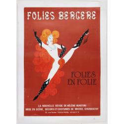
Folies Bergere - Folies en Folie!
Original advertising poster for the show " Folies en Folie! ", in the famous Les Folies Bergère cabaret in Paris. The Théâtre des Folies Bergère is a famous...
Date: Paris, ca. 1975
Selling price: ????
Please login to see price!
Sold in 2024
Workers - Hu Xian Peasant Painting.
Published by Shanghai renmin chubanshe (上海人民出版社).A fine Chinese propaganda posters at the tim...
Date: Shanghai, September, 1974 - variant 1975
Selling price: ????
Please login to see price!
Sold in 2018
![Ji shu ge xin kai hong hua. [Technological Innovation Makes Red Flowers Blossom].](/uploads/cache/42083-250x250.jpg)
Ji shu ge xin kai hong hua. [Technological Innovation Makes Red Flowers Blossom].
Chinese color propaganda poster shows four female workers in uniforms, each wearing a white apron with propaganda slogans on their stand on the factory floor with a woman...
Date: Shanghai, September, 1974 - variant 1975
Selling price: ????
Please login to see price!
Sold in 2019

十五的月亮 - Chinese propaganda.
Mao protect the children's from each country. Read more about Chinese propaganda posters [+]
Date: 1975
Selling price: ????
Please login to see price!
Sold in 2019
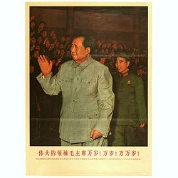
(Mao. Title in Chinese : The great leader, Long live Chairman ! Million years old! )
Mao zhu xi Chinese communism propaganda poster showing Mao Zedong[a] (1893 – 1976), commonly known as Chairman Mao.Published by Xinhua News agency, which was founded in...
Date: Beijing, ca. 1976
Selling price: ????
Please login to see price!
Sold in 2018
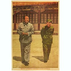
(Mao. Title in Chinese : Our great leader Chairman Mao and his close comrade Lin Biao.)
Mao zhu xi Chinese communism propaganda poster showing Mao Zedong[a] (1893 – 1976), commonly known as Chairman Mao.Published by Xinhua News agency, which was founded in...
Date: Beijing, 1976
Selling price: ????
Please login to see price!
Sold in 2018
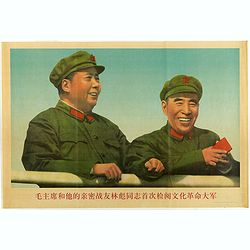
(Mao. Title in Chinese : 'Chairman Mao Zedong and his close friend comrade Lin Biao reviewing the cultural revolutionary army'.)
Mao zhu xi Chinese communism propaganda poster showing Mao Zedong[a] (1893 – 1976), commonly known as Chairman Mao.Published by Xinhua News agency, which was founded in...
Date: Beijing, 1976
Selling price: ????
Please login to see price!
Sold in 2018
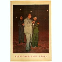
(Mao. Title in Chinese 'Chairman Mao and his close combat comrade Lin Biao and comrade Zhou Enlai )
Mao zhu xi Chinese communism propaganda poster showing Mao Zedong[a] (1893 – 1976), commonly known as Chairman Mao.Published by Xinhua News agency, which was founded in...
Date: Beijing, 1976
Selling price: ????
Please login to see price!
Sold in 2018
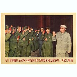
(Mao. Title in Chinese : 'Chairman Mao and his close comrades, Vice chairman Lin Biao and comrade Zhou Enlai stepped onto the Tiananmen Tower'.)
Mao zhu xi Chinese communism propaganda poster showing Mao Zedong[a] (1893 – 1976), commonly known as Chairman Mao.Published by Xinhua News agency, which was founded in...
Date: Beijing, 1976
Selling price: ????
Please login to see price!
Sold in 2018

(Mao. Title in Chinese 'The great leader Chairman Mao on the way of inspection' )
Mao zhu xi Chinese communism propaganda poster showing Mao Zedong[a] (1893 – 1976), commonly known as Chairman Mao.Published by Xinhua News agency, which was founded in...
Date: Beijing, 1976
Selling price: ????
Please login to see price!
Sold in 2018

The Soviet Political Poster.
An attractive Soviet Union political poster. The poster was part of a set of reproductions from posters originally published from 1919 to the 1970s. Published in Leningra...
Date: Leningrad, Aurora Art Publishers, 1976
Selling price: ????
Please login to see price!
Sold in 2022
The Soviet Political Poster.
An attractive Soviet Union political poster. The poster was part of a set of reproductions from poster originally published from 1919 to the 1970s. Published in Leningrad...
Date: Leningrad, Aurora Art Publishers, 1976
Selling price: ????
Please login to see price!
Sold in 2022
The Soviet Political Poster.
An attractive Soviet Union political poster. The poster was part of a set of reproductions from posters originally published from 1919 to the 1970s. Published in Leningra...
Date: Leningrad, Aurora Art Publishers, 1976
Selling price: ????
Please login to see price!
Sold in 2022
The Soviet Political Poster.
An attractive Soviet Union political poster. The poster was part of a set of reproductions from poster originally published from 1919 to the 1970s. Published in Leningrad...
Date: Leningrad, Aurora Art Publishers, 1976
Selling price: ????
Please login to see price!
Sold in 2023

The Soviet Political Poster.
An attractive Soviet Union political poster. The poster was part of a set of reproductions from posters originally published from 1919 to the 1970s. Published in Leningra...
Date: Leningrad, Aurora Art Publishers, 1976
Selling price: ????
Please login to see price!
Sold in 2023
The Soviet Political Poster.
An attractive Soviet Union political poster. The poster was part of a set of reproductions from posters initially published from 1919 to the 1970s. Published in Leningrad...
Date: Leningrad, Aurora Art Publishers, 1976
Selling price: ????
Please login to see price!
Sold in 2023
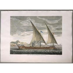
Galere a la voille portant l'Estendart de chef d'Escadre.
[Sailing Galley carrying l’Estendart of the leader of the Fleet], from: Les Plans de Plusieurs Bâtiments de Mer avec leurs proportions [Plans of Several Naval Structur...
Date: Marseille, ca. 1690 but 1977
Selling price: ????
Please login to see price!
Sold in 2020
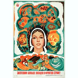
We will cook more vegetables and fruits for the country / Our agriculture is of high quality and efficiency!
Russian propaganda poster by the Armenian artist Eduard Simonovich Artsrunian (?????? ????????? ????????), - ????????? ?????? ?????? ? ??????? ?????? / ????????? ????????...
Date: Moscow, 1977
Selling price: ????
Please login to see price!
Sold in 2021
![[Anti capitalism Soviet Union propaganda poster]](/uploads/cache/47039-250x250.jpg)
[Anti capitalism Soviet Union propaganda poster]
Propaganda mini anti-capitalism poster published in Russia during The Cold War. By the 1960’s and 1970’s, outrageous practices in Soviet bureaucracy flourished. Poor ...
Date: Leningrad, 1978
Selling price: ????
Please login to see price!
Sold in 2024
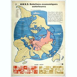
U.R.S.S. Relations économiques extérieures. (7)
World map centred on Russia. Propaganda poster for Russia's in and export of industrial goods. With a numbered key (1-30). Editions de l'Agence de presse Novosti".Mo...
Date: USSR, 1978
Selling price: ????
Please login to see price!
Sold in 2017
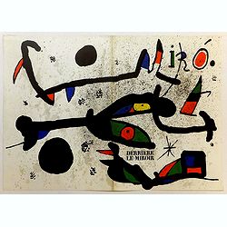
Cover for Derrière le miroir.
Beautiful cover page made by the surrealist master Mirò in typical bright colors. This is an original color lithograph from the magazine "Behind the Mirror" (n...
Date: Paris, 1978
Selling price: ????
Please login to see price!
Sold in 2020
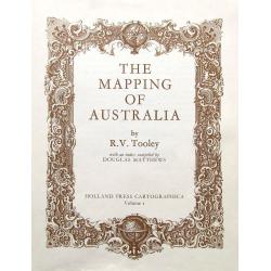
The Mapping of Australia.
The definitive book about maps of Australia by R. V. Tooley. Includes many illustrations, also including early South-East Asia maps. Holland Press Cartographica. Vol I.
Date: London, 1979
Selling price: ????
Please login to see price!
Sold in 2020
![[Anti capitalism Soviet Union propaganda poster]](/uploads/cache/47023-250x250.jpg)
[Anti capitalism Soviet Union propaganda poster]
Propaganda mini anti-capitalism poster published in Russia during The Cold War. By the 1960’s and 1970’s, outrageous practices in Soviet bureaucracy flourished. Poor ...
Date: Leningrad, 1979
Selling price: ????
Please login to see price!
Sold in 2022

China
Pictorial map by the Italian artist Andrea Pistacchi.
Date: Italy, ca. 1980
Selling price: ????
Please login to see price!
Sold in 2020
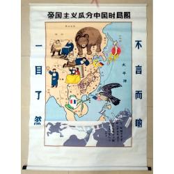
Map of the Imperialist Division of China
Unusual, large silkscreened map of China based on the serio-comic map drawn in 1899 by Tse Tsan-tai, Chinese patriot and co-founder of Hong Kong's South China Morning Po...
Date: China, C. 1960-1980
Selling price: ????
Please login to see price!
Sold in 2023

Flordali II - La rose papillon. (The pink butterfly)
Large size lithographed and embossed poster. Signed in the plate. Printed by Atelier Matthieu in a few hundred examples, but without the publisher stamp and on thin vellu...
Date: Paris, 1981
Selling price: ????
Please login to see price!
Sold in 2020
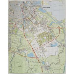
Nederland 1 : 25.000 Blad 25D Amstelveen.
Folding-map of southern part of Amsterdam, Amsterdam Zuid-Oost , Ouderkerk aan de Amstel, Abcoude and part of Amstelveen. First edition in 1977, then corrected in 1981 by...
Date: Netherlands, 1977, revised 1981
Selling price: ????
Please login to see price!
Sold in 2009