Browse Listings
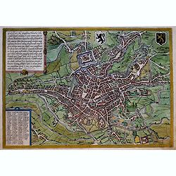
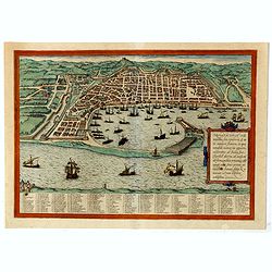
Gandavum (Ghent)
Very desirable and early town-plan of Ghent. In lower left corner a numbered key (1-103). "The view of Ghent shows the city from the northwest in plan view from a gr...
Date: Cologne, (1572) 1577
Selling price: ????
Please login to see price!
Sold in 2019
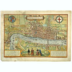
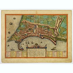
Londinum Feracissimi Angliae Regni Metropolis.
Very desirable and early plan of London - in a second state - shown from the Tower to Westminster, with the City already built-up and a ribbon development westwards along...
Date: Cologne, (1572) 1577
Selling price: ????
Please login to see price!
Sold in 2018
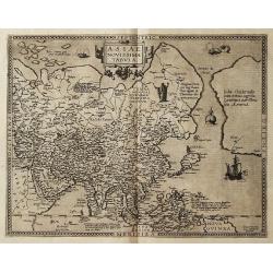
![Calechut Celeberrimum Indiae Emporium [on sheet with] Ormus [and] Canonor [and] S. Georgii Oppidum Mina.](/uploads/cache/41270-250x250.jpg)
Calechut Celeberrimum Indiae Emporium [on sheet with] Ormus [and] Canonor [and] S. Georgii Oppidum Mina.
Four very desirable and early town-plans of Kozhikode, Hormuz, Kannur and Almina. "KOZHIKODE (CALICUT) : "The city is viewed from the sea, just as it would hav...
Date: Cologne, (1572) 1577
Selling price: ????
Please login to see price!
Sold in 2018
![Heidelberga - Florentissimae civitatis Heidelbergensis . . . [on sheet with] Spira Celebris admodum Imperij & episcopalis in Germania civitas ... [and] Wormacia vetustissima Vangionum civitas . . .](/uploads/cache/42417-250x250.jpg)
Heidelberga - Florentissimae civitatis Heidelbergensis . . . [on sheet with] Spira Celebris admodum Imperij & episcopalis in Germania civitas ... [and] Wormacia vetustissima Vangionum civitas . . .
Three very desirable and early town-plans of Heidelberg, Speyer and Worms in a first state. "HEIDELBERG :The view of the city and castle overlooking the Neckar is pr...
Date: Cologne, (1572) 1577
Selling price: ????
Please login to see price!
Sold in 2020
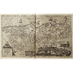
Messana, Urbs est Sicilie maxima, situ, opulentia, & tuta navium statione.
A very desirable and early town-plan of Messina on Sicily, with a numbered key (1-167) in lower part. "Messina is shown from the east, in a view looking down upon th...
Date: Cologne, (1572) 1577
Selling price: ????
Please login to see price!
Sold in 2020
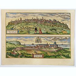
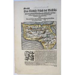
Orvieto / Lauretum.
Orivetum, in Italian Orvieto, a town in the well-known Italian region of Tuscia. Braun says, "Orvieto is a city in the heart of Etruria, lying on the flat top of a v...
Date: Cologne, 1577
Selling price: ????
Please login to see price!
Sold in 2020
Messana, Urbs est Sicilie maxima, situ, opulentia, & tuta navium statione.
A very desirable and early town-plan of Messina on Sicily, with a numbered key (1-167) in lower part. "Messina is shown from the east, in a view looking down upon th...
Date: Cologne, (1572) 1577
Selling price: ????
Please login to see price!
Sold in 2019
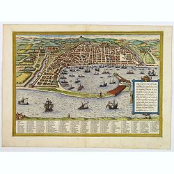
Ancona Civitas Piceni Celeberrima, ad Mare Adriaticum Posita . . .
Very desirable and early town-plan of Ancona with a numbered key (1-45) in bottom.. "Ancona is seen here from Adriatic in bird's-eye view.The curved natural harbour ...
Date: Cologne, (1572) 1577
Selling price: ????
Please login to see price!
Sold in 2021
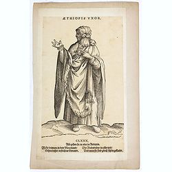
Aethiopis Vxor. (CLXXX)
A African woman standing with floor-length dress. Woodcut by Jost Amman after Weigel. From H. Weigel, "Trachtenbuch". - "The woodcuts have ... above Latin ...
Date: Cologne, ca. 1577
Selling price: ????
Please login to see price!
Sold in 2019
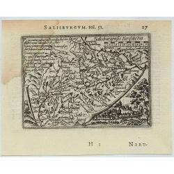
Salisburgum.
A miniature map Salzburg, Austria. Ortellius map taken from the first French edition of Le Miroir du Monde, published by Galle & Heyns in 1577 and printed by Plantin...
Date: Antwerp, 1577
Selling price: ????
Please login to see price!
Sold in 2019
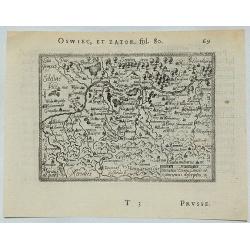
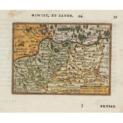
Oswiec, et Zator.
A miniature map depicting the Duchies of Oswieczin and Zator in the southern part of Poland. (Prussia). Ortellius map taken from the first French edition of Le Miroir du...
Date: Antwerp, 1577
Selling price: ????
Please login to see price!
Sold in 2021
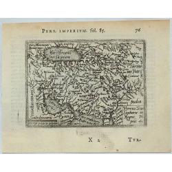
Percici Siuc Sophorum Regni Tipus.
This is a miniature map of Iran and Arabia in central Asia. Ortellius map taken from the first French edition of Le Miroir du Monde, published by Galle & Heyns in 157...
Date: Antwerp, 1577
Selling price: ????
Please login to see price!
Sold in 2021
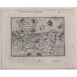
Pomerania Wandalicae Regionis Tipus.
This map of Poland (Pomerania) has fine detail and attractive engraving; the region shown includes the cities of Dantz, Stettin, Colberg, Lansperg, Gartz; major rivers an...
Date: Antwerp, 1577
Selling price: ????
Please login to see price!
Sold in 2020
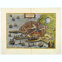
![Toletum/Toledo [on sheet with] Vallisoletum / Valladolid.](/uploads/cache/83225-250x250.jpg)
Toletum/Toledo [on sheet with] Vallisoletum / Valladolid.
TOLEDO : A very desirable and early town-view of Toledo, rendered with great precision as almost every house seems to be individually drawn. The churches and the Alcà¡s...
Date: Cologne, (1572) 1577
Selling price: ????
Please login to see price!
Sold in 2019
![HAIDELBERGA- Florentissimae civitatis Heidelbergensis . . . [on sheet with] SPIRA Celebris admodum Imperij & episcopalis in Germania civitas ... [and] WORMACIA vetustissima Vangionum civitas...](/uploads/cache/84002-250x250.jpg)
HAIDELBERGA- Florentissimae civitatis Heidelbergensis . . . [on sheet with] SPIRA Celebris admodum Imperij & episcopalis in Germania civitas ... [and] WORMACIA vetustissima Vangionum civitas...
Three very desirable and early town-plans of Heidelberg, Speyer and Worms in a first state."HEIDELBERG: The view of the city and castle overlooking the Neckar is pre...
Date: Cologne, (1572) 1577
Selling price: ????
Please login to see price!
Sold in 2020
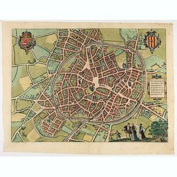
Mechelen - Nitidissimae Civitatis Mechlineensis in meditullio Brabantiae sitae, exactis: delineatio.
Very desirable and early town-plan of Mechelen with the city scape is dominated by the massive tower belonging to the cathedral of Sint-Rombout, which measures almost 100...
Date: Cologne, (1572) 1577
Selling price: ????
Please login to see price!
Sold in 2020
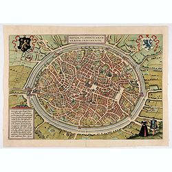
Brugae, Flandricarum urbium ornamenta.
Very desirable and early town-plan of Bruges.From volume one of the greatest publication in this genre!. The Civitates was compiled and written by George Braun, Canon of ...
Date: Cologne, (1572) 1577
Selling price: ????
Please login to see price!
Sold in 2020
![Calechut Celeberrimum Indiae Emporium [on sheet with] Ormus [and] Canonor [and] S. Georgii Oppidum Mina.](/uploads/cache/46221-250x250.jpg)
Calechut Celeberrimum Indiae Emporium [on sheet with] Ormus [and] Canonor [and] S. Georgii Oppidum Mina.
Four very desirable and early town-plan of Kozhikode, Hormuz, Kannur and Almina. "KOZHIKODE (CALICUT) : "The city is viewed from the sea, just as it would have...
Date: Cologne, (1572) 1577
Selling price: ????
Please login to see price!
Sold in 2022
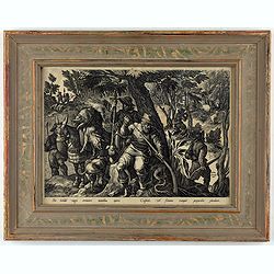
Sic hastile vagis errantes montibus apres - culpide, vel flamma rumpit precordia plumbum.
This is a plate from a series "Venationes ferarum, avium, piscium, pugnae bestiariorum & mutuae bestiarum". Published by Philippe Galle (Haarlem 1537 - 1612...
Date: Antwerp, Philips Galle, ca 1577
Selling price: ????
Please login to see price!
Sold in 2021
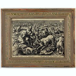
Sic ferus exardet in circo taurus aperto - Cum sua terribili petit iritamina cornu.
This is a plate from a series "Venationes ferarum, avium, piscium, pugnae bestiariorum & mutuae bestiarum". Published by Philippe Galle (Haarlem 1537 - 1612...
Date: Antwerp, Philips Galle, ca 1577
Selling price: ????
Please login to see price!
Sold in 2024
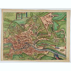
Roma.
Very desirable and early of Rome in a first state. With a numbered key (1-101) in lower part. "This engraving of Rome shows the city around 1550 in its imposing sett...
Date: Cologne, (1572) 1577
Selling price: ????
Please login to see price!
Sold in 2022
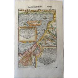
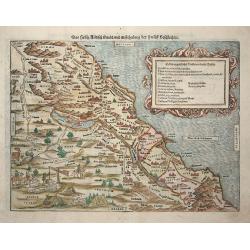
Holy Land. Die Tafel gibt ein klein anzeigung...
Early, attractive woodcut map of the Holy Land with Cyprus. On the full page. From the German edition of Sebastian Münster's Cosmography, titled Cosmographey oder beschr...
Date: Basel, 1578
Selling price: ????
Please login to see price!
Sold in 2020
Geldria.
A very rare first state of Gerard de Jode's map of the Dutch Duchy of Geldria, after Johannes van Deurecom:' 'Ioannes Duetecu[m] [and] Lucas, à Duetecum fecerunt’ Fro...
Date: Antwerp, 1578
Selling price: ????
Please login to see price!
Sold in 2022
Africa mit seinen besundern Leandern / Thieren / und wunderbarlichen Dingen. (...)
A very early and attractively coloured map of Africa. A full leaf from the Cosmographei, published in Basel by Heinrich Petri in 1578. With a beautiful woodcut initial le...
Date: Basel, 1578
Selling price: ????
Please login to see price!
Sold in 2021
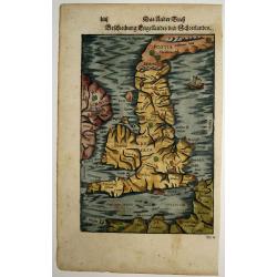
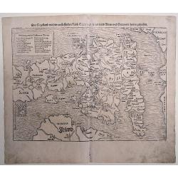
Beschreibung Engellands und Schottlandts
A very early and attractively coloured map of the UK, Engeland, Schotland, Ireland, and Wales, on a full leaf. A wonderful woodcut with picturesquely cut cities, seas and...
Date: Basel, 1578
Selling price: ????
Please login to see price!
Sold in 2021
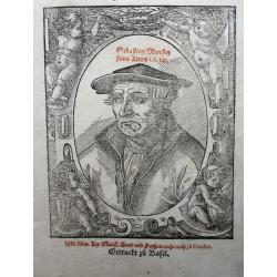
Cosmographey Oder beschreibung Aller Länder herrschafftenn vnd fürnemesten Stetten des gantzen Erdbodens: sampt jhren Gelegenheiten, Eygenschafften, Religion, Gebreuchen, Geschichten vnnd Handthierungen, etc.
The portrait of Sebastian Münster aged 60, as part of a separate typographical titlepage, printed subsequently in red and black.
Date: Basel, 1578
Selling price: ????
Please login to see price!
Sold in 2022
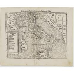
Italia mit den Dreien Furnemsten Inseln Corsica / Sardinia und Sicilia.
One of the earliest woodblock map of Italy. It shows the area from Marseille to Albania, including the Adriatic Sea, also the islands of Sicily, Corsica and Sardinia. The...
Date: Basel, 1578
Selling price: ????
Please login to see price!
Sold in 2023
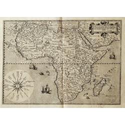
Africae ut terra mariq, lustrata est, proprijssima..
Map of the continent of Africa from the extremely rare first edition. With ''cum priuilegio'' added. Engraved by Joannes and Lucas van Deutecum, who's signature is in the...
Date: Antwerp 1578
Selling price: ????
Please login to see price!
Sold
Europae totius orbis partium amoenissimae..
Map of Europe from the extremely rare first edition.With ''cum priuilegio'' added.Engraved by Joannes and Lucas van Deutecum, who's signature is in the lower left corner...
Date: Antwerp 1578
Selling price: ????
Please login to see price!
Sold
Asiae novissima tabula.
Map of Asia, including the most western part of America from the extremely rare first edition. De Jode describes this map as new, as he extended the map westward from Ort...
Date: Antwerp 1578
Selling price: ????
Please login to see price!
Sold
Terrae Sanctae quae Promissionis terra, est Syriae pars,..
Map of Holy land from the extremely rare first edition.. This map shows the Mediterranean at the top while the entire lower right offers a detailed view of Jerusalem. Eng...
Date: Antwerp 1578
Selling price: ????
Please login to see price!
Sold
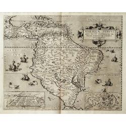
Americae Pervvi aqve ita vt postremvm detecta traditvr recens delineatio.
Map of Central and South America from the extremely rare first edition.. This map shows South America, part of Mexico, Caribbean and the southern tip of Florida. In lower...
Date: Antwerp 1578
Selling price: ????
Please login to see price!
Sold
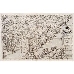
Tertiae Partis Asiae..
Map of India, Malaysia, China's south coast, Philippines, northern part of Sumatra, Borneo. From the extremely rare first edition.. Engraved by Joannes and Lucas van Deut...
Date: Antwerp 1578
Selling price: ????
Please login to see price!
Sold
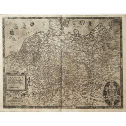
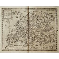
GERMANIA universa, Europae totius..
Map of Germany, Poland, Austria and the Netherlands from the extremely rare first edition.With ''cum priuilegio'' added. Engraved by Joannes and Lucas van Deutecum, who's...
Date: Antwerp 1578
Selling price: ????
Please login to see price!
Sold
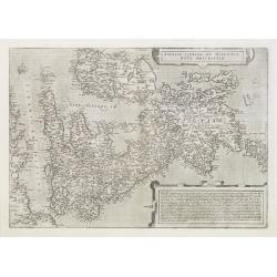
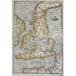
Angliae Scotiae et Hibernie nova descriptio.
FIRST EDITION of this fine example of De Jode's rare map of the British Isles, oriented with West at the top. The map was based on Mercator's wall map from 1554. From the...
Date: Antwerp 1578
Selling price: ????
Please login to see price!
Sold
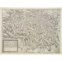
Helvetiae sev sviciae qvae mvltis confoederatorvm terra dicitvr primmae Germanorvm provinciae Galliae Italiae qvae contigvae chorographia vera et elegans avtore.
FIRST EDITION of this fine example of De Jode's rare map of Switzerland. From the first edition of De Jode's Speculum Orbis Terrarum, the second general atlas of the worl...
Date: Antwerp 1578
Selling price: ????
Please login to see price!
Sold
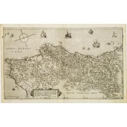
Portvgalliae qvae olim Lvsitania Vernando Alvaro Secco avtore recens descriptio.
FIRST EDITION of this fine example of De Jode's rare map of Portugal. From the first edition of De Jode's Speculum Orbis Terrarum, the second general atlas of the world, ...
Date: Antwerp 1578
Selling price: ????
Please login to see price!
Sold
Italia totius orbis olim domatricis nova et exactiss descriptio Jacobo Castaldo auctore.
Map of Italy from the extremely rare first edition, here the state without the privilege. Engraved by Joannes and Lucas van Deutecum, who's signature is in the lower left...
Date: Antwerp, 1578
Selling price: ????
Please login to see price!
Sold
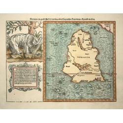
Sumatra ein grosse insel..
Map of island of Taprobana, which was variously thought to be Ceylon or Sumatra. This map depicts Ceylon with the typical misconceptions of Ptolemy showing a small part o...
Date: Basle, 1578
Selling price: ????
Please login to see price!
Sold in 2009
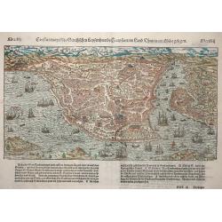
Constantinopel
Detailed bird's-eye view of the Golden Horn of Constantinople. The city plan depicts the markets, homes, palaces and churches, including the famous Hagia Sophia, shown pr...
Date: Basle, 1578
Selling price: ????
Please login to see price!
Sold in 2009
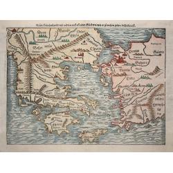
Neuw Griechenlandt ..
An early double-page woodblock map of Greece, the Aegean Sea and western Turkey. It locates Athens, Constantinople, Arcadia, Crete, Rhodes, Bursa (Byrsa), and more, exten...
Date: Basle 1578
Selling price: ????
Please login to see price!
Sold in 2008
Das Heilig Judisch Land mit Ausztheilung der Zwolff Geschlechter.
Munster based this map of the Holy Land on maps by Mercator and Ziegler and filled it with numerous woodcut vignettes. The unusual orientation of the map places west at t...
Date: Basle 1578
Selling price: ????
Please login to see price!
Sold in 2009
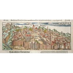
Die heilige statt Jerusalem contrafehtet nach form und gestalt..
Bold woodcut view of Jerusalem from an edition of Munster's Cosmographia. Well-detailed birds-eye view from outside the walls with numerous buildings and temples named. O...
Date: Basle, 1578
Selling price: ????
Please login to see price!
Sold in 2009
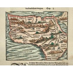
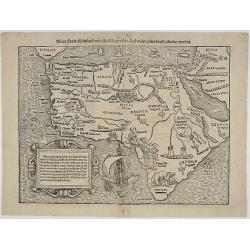
Africa
Strongly engraved woodblock map of the continent depicts the Nile's origins in twin lakes originating in the Motes Lunae, or Mountains of the Moon, based on Ptolemy's acc...
Date: Basle, 1578
Selling price: ????
Please login to see price!
Sold in 2008
Appendix III Tabulae Afr:
Ptolemaic map of Egypt bu Mercator.
Date: Cologne, 1578
Selling price: ????
Please login to see price!
Sold in 2010
Europae II Tab:
Ptolemaic map of Spain by Mercator.
Date: Cologne, 1578
Selling price: ????
Please login to see price!
Sold in 2010
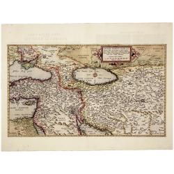
Asiae Tab.VI.
Finely engraved, this classical map of the Arabia peninsula after Ptolemy from the renowned Gerhard Mercator. The map shows the Gulf of Persia in an almost rectangular f...
Date: 1578
Selling price: ????
Please login to see price!
Sold in 2015
Nova et Castigator Comitatus Hollandiae Descriptio . . .
A second state of the first plate of the province of North and South Holland in the Netherlands. With the engraved signature of Joannes and Lucas van Deutecum in the lowe...
Date: Antwerp, ca. 1578
Selling price: ????
Please login to see price!
Sold in 2015
![[Europe in the shape of a Queen.]](/uploads/cache/94509-250x250.jpg)
[Europe in the shape of a Queen.]
From 'Cosmographia, das ist: Beschreibung der Gantzen Welt,...'; German edition. wood engraving; overall size 34 x 21 cm. On verso: German text with high-lightened capita...
Date: Basle, c1578
Selling price: ????
Please login to see price!
Sold in 2016
Engellandt/ mit dem anstossenden Reich Schottlandt/ so vorzeiten Albion und Britannia haben geheissen.
From 'Cosmographia, das ist: Beschreibung der Gantzen Welt,...'; German edition. wood engravings set into text; overall size 33 x 20 cm. on verso: engraved title. Münst...
Date: Basle, c. 1578
Selling price: ????
Please login to see price!
Sold in 2015
Beschreibung Engellandts und Schottlandts.
From 'Cosmographia, das ist: Beschreibung der Gantzen Welt,...'; published in Basle, c1578, German edition.wood engraving set into text; overall size 33 x 20 cm. On verso...
Date: Basle, c. 1578
Selling price: ????
Please login to see price!
Sold in 2015
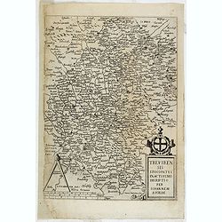
Trevirensis Episcopatus Exactissimo Decriptio Per Iohannem Scilde.
Map of Trier, prepared by J. van Schilde and engraved by Johan van Doetichum. From the first edition of De Jode's Speculum Orbis Terrarum, the second general atlas of the...
Date: Antwerp, 1578
Selling price: ????
Please login to see price!
Sold in 2015
Das Engellandt/ mit dem anstossenden Reich Schottland/ so vorzeiten Albion und Britannia/ haben geheissen.
A woodcut map; on laid paper. This map is from the last German edition of the well-published 'Cosmographia', with Scotland orientated to the West. The map is decorated wi...
Date: Basle, 1578
Selling price: ????
Please login to see price!
Sold in 2016
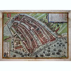
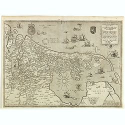
Amstelredamum, Nobile Inferioris Germaniae Oppidum . . . (Amsterdam)
Very desirable and early town-plan of Amsterdam from a north-easterly direction. With a numbered key (1-28) in lower left corner. "On the left-hand side we can see h...
Date: Cologne, (1572) 1578
Selling price: ????
Please login to see price!
Sold in 2017
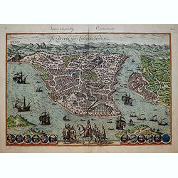
Byzantium, Nunc Constantinopolis..
One of the finest and most sought-after views of Istanbul. Viewed from the village of Scutari, the City is shown with all its fortifications, the original Genoese distric...
Date: Cologne, 1578
Selling price: ????
Please login to see price!
Sold in 2017
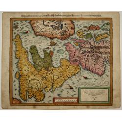
Barhasste Contraschtung der Statt Haerlem.
Very attractive and detailed birds-eye plan of Haarlem, Holland showing the full extent of rivers and moated fortification. It is set in a page of Old German text with te...
Date: Basel, 1578
Selling price: ????
Please login to see price!
Sold in 2018
Von der Statt Cales.
Very attractive and detailed birds-eye plan of Calais, France showing the full extent of rivers and moated fortification. It is set in a page of Old German text with text...
Date: Basel, 1578
Selling price: ????
Please login to see price!
Sold in 2017
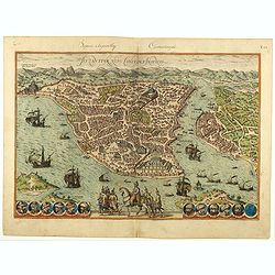
Byzantium, Nunc Constantinopolis..
One of the finest and most sought-after views of Istanbul. Viewed from the village of Scutari, the City is shown with all its fortifications, the original Genoese distric...
Date: Cologne, 1578
Selling price: ????
Please login to see price!
Sold in 2020
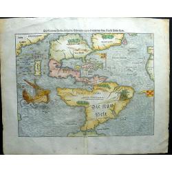
America. Die Neüwen Inseln so hinder Hispanien gegen Orient, bey dem Landt Indie ligen.
A very rare state of the earliest separate map to show both North and South America. One of the first maps also to include Japan, and the first to refer to "Mare Pac...
Date: Basel, 1578
Selling price: ????
Please login to see price!
Sold in 2018
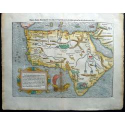
Africa / Libya / Mörenlandt / mit allen Königreichen / so zu unsern zeiten darin gefunden werden.
A wonderfully decorative and extremely interesting map of the continent of Africa by Sebastian Münster. The map features a galleon, mountains, rivers, assorted kings cro...
Date: Basel, 1578
Selling price: ????
Please login to see price!
Sold in 2018
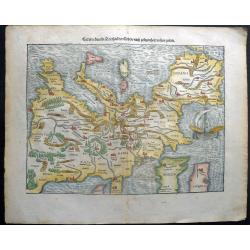
Europa, das ein Drittheil der Erden / nach gelegenheit unsern zeiten.
At the time Sebastian Münster published this map, it was not yet conventional to orient the North at the top. The uncommon orientation to the South for this map was deri...
Date: Basel, 1578
Selling price: ????
Please login to see price!
Sold in 2018
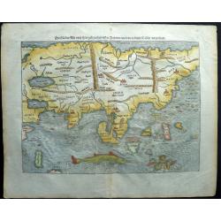
Asia, die Länder Asie nach ihrer gelegenheit biss in Indiam werden in dieser Tafeln verzeichnet.
This is one of the earliest maps of the whole continent of Asia, based on the recent geographical discoveries by Portuguese navigators. The outline of the Asian mainland ...
Date: Basel, 1578
Selling price: ????
Please login to see price!
Sold in 2018
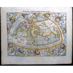
Ptolemaisch general tafel, begreiffend die halbe Kugel der Welt.
A lovely full color example Sebastian Münster's Ptolemaic world map, from the "Cosmographia" of 1578. Relief is shown pictorially. The Ptolemaic map shows the ...
Date: Basel, 1578
Selling price: ????
Please login to see price!
Sold in 2018
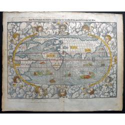
Das Erst General, inhaltend die beschreibung und den Circkel des gantzen Erdrichs und Möres.
A beautiful oval full color example of Sebastian Münster's new world map, from the "Cosmographia" of 1578. Relief is shown pictorially. The map is embellished ...
Date: Basel, 1578
Selling price: ????
Please login to see price!
Sold in 2018
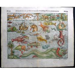
Mörwunder und seltzame Thier, wie die in Mitnächtigen Ländern gefunden werden.
In the early days of the era of discoveries, many ships would depart, never be seen again. Sailors that managed to return used to speak of encounters with large fish that...
Date: Basel, 1578
Selling price: ????
Please login to see price!
Sold in 2018
Flissinga munitissimu Zelandiae. . .
A fine bird's-eye view of the town of Vlissingen in Zeeland. It is situated at the mouth of the western Schelde. You see an excellent overview of the town's layout, and i...
Date: Cologne, 1578
Selling price: ????
Please login to see price!
Sold in 2020

Diversi Dithmarsorum et vicinarum gentium habitus.
An interesting and unusual print of the various costumes from Dithmarschen and the surrounding areas. This print is made up of three rows of assorted costumed peoples. So...
Date: Cologne, 1578
Selling price: ????
Please login to see price!
Sold in 2020
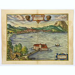
Gmunden.
A wonderful bird's-eye view of the small town of Gmunden, in the upper Archduchy of Austria, well situated by a lake. The surrounding mountains supply salt, from which a ...
Date: Cologne, 1578
Selling price: ????
Please login to see price!
Sold in 2020
Africa / Libya / Morenlandt / mit allen Königreichen / so zu unsern zeiten darin gefunden werden.
A decorative Münster's map of Africa, the first map of the African Continent. The map features a galleon, mountains, rivers, assorted kings crowns, denoting various king...
Date: Basel, 1578
Selling price: ????
Please login to see price!
Sold in 2021
Primae Partis Asiae.
The Very Rare First State. Turkey/ Holy Land/ Iran/ Iraq/ Arabia/ Afganistan.
Date: Antwerp, 1578
Selling price: ????
Please login to see price!
Sold
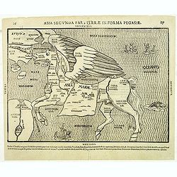
Asia secunda pars terrae in forma Pegasir.
Map of Asia in the form of a Pegasus. The seas are adorned with sea monsters and many major cities are indicated and named. There are several states, of this map.Bünting...
Date: Magdeburg,. 1579
Selling price: ????
Please login to see price!
Sold in 2012
Indiae Orientalis Insularumque Adiacientium Typus.
Famous milestone map of South-East Asia, China, Japan, Indonesia, and the Philippines. The map also includes parts of the West Coast of North America, including several m...
Date: Antwerp, 1579
Selling price: ????
Please login to see price!
Sold in 2012
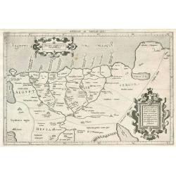
Ducatus Osroiczensis et zatoriensis descriptio.
Charming miniature version of Ortelius' map covering Lesser Poland. French text on verso.
Date: Antwerp, 1579
Selling price: ????
Please login to see price!
Sold in 2012
Africae Tabula Nova.
From the 'Typus Orbis Terrarum', Latin Text - Striking continental map designed by Ortelius from elements of contemporary maps by Gastaldi, Mercator, and Forlani. It is c...
Date: Antwerp, 1579
Selling price: ????
Please login to see price!
Sold in 2012
Anglia et Hibernia Nova. . .
One of the earliest maps of Great Britain.Girolamo Ruscelli's edition of Ptolemy's Geographia included newly engraved copperplates by Giulio and Livio Sanuti. From the se...
Date: Venice, 1579
Selling price: ????
Please login to see price!
Sold in 2013
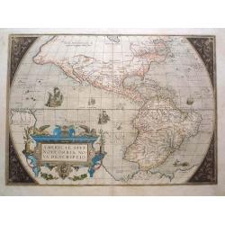
Americae sive Novi Orbis Nova Descriptio.
A derivative of Mercator's large map published the year before, this is the second plate of Ortelius's map of the Americas, with the ship in the Pacific sailing East ward...
Date: Antwerp, 1579
Selling price: ????
Please login to see price!
Sold in 2016
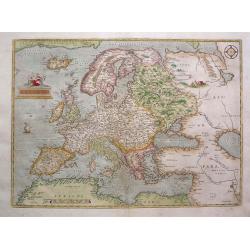
Europae.
A classic map of Europe derived from Mercator's work; Russia from Jenkinson's map; Scandinavia from Olaus Magnus. The relatively modest cartouche shows a partially covere...
Date: Antwerp, 1579
Selling price: ????
Please login to see price!
Sold in 2013
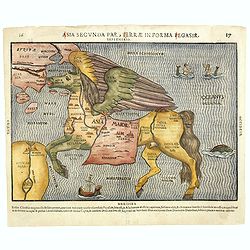
Asia secunda pars terrae in forma Pegasi.
Wood block map of Asia in the form of a Pegasus. The seas are adorned with sea monsters and many major cities are indicated and named. There are several states, of this m...
Date: Magdeburg, ca. 1579
Selling price: ????
Please login to see price!
Sold in 2021
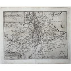
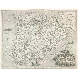
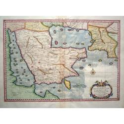
Austriae Ducatus Chorographia, Wolfgango Lazio Auctore.
A highly decorative early map of the duchy of Austria, engraved after the cartographic source by Wolfgang Lazius.Centered on the stretch of the Danube from Linz to Bratis...
Date: Antwerp, 1579
Selling price: ????
Please login to see price!
Sold in 2014
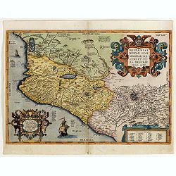
Hispaniae novae sive magnae recens et vera descriptio. 1579
This was the standard map of the area for a generation, copied by De Bry, Quad and Hondius. Even though Herrera (Spain's Royal Cosmographer) and Wytfliet worked 20 years ...
Date: Antwerp, 1579
Selling price: ????
Please login to see price!
Sold in 2016