Please login to see price!.
Subscribe to be notified if similar examples become available.
Ch'onhado (Map of the world beneath the heavens) |
||||||||||||||||||||
|
||||||||||||||||||||
|
|
||||||||||||||||||||
|
Selling price: $...
Please login to see price! Sold in 2014 Missed this item! Be the first to get notified about our newly added listings. Add your name to our mailing list. Feel free to contact us if you have a question about this item. |
Virtual Collection - Save and collect this or any of your favorite items in one place.
If you want to save the items permanently, please sign in or create account first. |
|||||||||||||||||||
Description
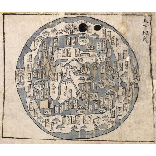
The Ch'onhado, literally "Map of the world beneath the heavens"), or sometimes Cheonha jeondo, literally "Complete map of the world beneath the heavens), is a peculiar type of circular world map developed in Korea during the 17th century. It is based on the Korean term for map, chido, translated roughly as "land picture".
This printed Ch'onhado, or world map, is the first map in an Korean atlas and was perhaps copied from a Chinese source. The place names are derived from mythical places noted in Chinese classics and from known lands around China, which occupies the center of the map.
The map has been pasted in a mount and has an early 20 century Asian frame. Additional shipping costs if shipped with frame.
The Ch'onhado maps were made in response to the encounter with the geographical knowledge of the West, but based in content on traditional Asian sources and Asian in style. The structure of the maps consists of an internal continent with historical place names, an internal sea with place names connected to descriptions of Taoist immortality, an external continent, and an external sea.
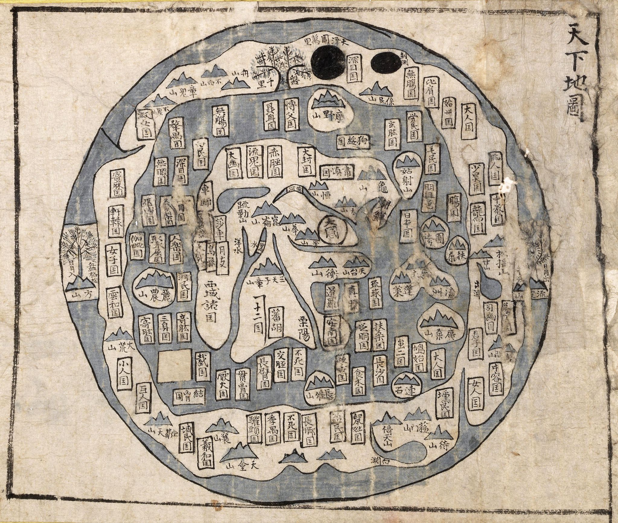
The structure of the map is simple. A main continent, containing China, Korea, and a number of historically known countries, occupies the center of the circular map, surrounded by an enclosing sea ring, which is itself surrounded by an outer land ring. Surprisingly, the maps did not reflect the highest levels of geographic knowledge available to Koreans, but this is not likely to be intentional. Some of this was due to the nautical distance between Korea and other Southeast Asian locales affected the mapmakers perceptions of Asia. Similarly, European mapmakers of the day often treated Korea as an island.
Some scholars have attributed the development of Korean circular world maps to Western influence, such as the maps of Matteo Ricci (Kunyu Wanguo Quantu) or the maps of Giulio Aleni (Wanguo Quantu). In this case, the central landmass can be viewed as a combination of Asia, Africa, and Europe, and the external "ring" continent as North America and South America.
The central continent represents Asia alone, India being at the southwest corner. The only rivers definitely given are the Yellow River, the Yang-tse, and the Mekong, all of which are represented fairly well. The general course of these rivers is only approximated here. It is interesting to note that China proper is represented as lying between the Yellow River and the Yang-tse, which, as history proves, was the real birthplace of the Chinese people.
Korea and the Yellow Sea are also well represented, but when we go farther afield than this we find confusion. Annam is not far out of the way; but the land to the west of it, which must represent Siam [Thailand] and Burma, is highly fanciful. The water to the east of India must be the Bay of Bengal, and the two forks at the head of it may represent the Irrawaddy and Salween Rivers. If this is so, the Kwen-lun Mountains are not far enough out of their proper place to call for severe criticism.
The title is to the right corner. Such maps were produced in Korea only, and have not been found in China or Japan. The Cheonhado remained popular in Korea until the late 19th century.
This printed Ch'onhado, or world map, is the first map in an Korean atlas and was perhaps copied from a Chinese source. The place names are derived from mythical places noted in Chinese classics and from known lands around China, which occupies the center of the map.
The map has been pasted in a mount and has an early 20 century Asian frame. Additional shipping costs if shipped with frame.
The Ch'onhado maps were made in response to the encounter with the geographical knowledge of the West, but based in content on traditional Asian sources and Asian in style. The structure of the maps consists of an internal continent with historical place names, an internal sea with place names connected to descriptions of Taoist immortality, an external continent, and an external sea.
The structure of the map is simple. A main continent, containing China, Korea, and a number of historically known countries, occupies the center of the circular map, surrounded by an enclosing sea ring, which is itself surrounded by an outer land ring. Surprisingly, the maps did not reflect the highest levels of geographic knowledge available to Koreans, but this is not likely to be intentional. Some of this was due to the nautical distance between Korea and other Southeast Asian locales affected the mapmakers perceptions of Asia. Similarly, European mapmakers of the day often treated Korea as an island.
Some scholars have attributed the development of Korean circular world maps to Western influence, such as the maps of Matteo Ricci (Kunyu Wanguo Quantu) or the maps of Giulio Aleni (Wanguo Quantu). In this case, the central landmass can be viewed as a combination of Asia, Africa, and Europe, and the external "ring" continent as North America and South America.
The central continent represents Asia alone, India being at the southwest corner. The only rivers definitely given are the Yellow River, the Yang-tse, and the Mekong, all of which are represented fairly well. The general course of these rivers is only approximated here. It is interesting to note that China proper is represented as lying between the Yellow River and the Yang-tse, which, as history proves, was the real birthplace of the Chinese people.
Korea and the Yellow Sea are also well represented, but when we go farther afield than this we find confusion. Annam is not far out of the way; but the land to the west of it, which must represent Siam [Thailand] and Burma, is highly fanciful. The water to the east of India must be the Bay of Bengal, and the two forks at the head of it may represent the Irrawaddy and Salween Rivers. If this is so, the Kwen-lun Mountains are not far enough out of their proper place to call for severe criticism.
The title is to the right corner. Such maps were produced in Korea only, and have not been found in China or Japan. The Cheonhado remained popular in Korea until the late 19th century.
FAQ - Guarantee - Shipping
Buying in the BuyNow Gallery
This item is available for immediate purchase when a "Add to Cart" or "Inquire Now" button is shown.
Items are sold in the EU margin scheme
Payments are accepted in Euros or US Dollars.
Authenticity Guarantee
 We provide professional descriptions, condition report (based on 45 years experience in the map business)
Paulus Swaen warrants the authenticity of our items and a certificate of authenticity is provided for each acquired lot.
Condition and Coloring
We indicate the condition of each item and use our unnique HiBCoR grading system in which four key items determine a map's value: Historical Importance, Beauty, Condition/Coloring and Rarity.
Color Key
We offer many maps in their original black and white condition. We do not systematically color-up maps to make them more sellable to the general public or buyer.
Copper engraved or wood block maps are always hand colored. Maps were initially colored for aesthetic reasons and to improve readability. Nowadays, it is becoming a challenge to find maps in their original colors and are therefor more valuable.
We use the following color keys in our catalog:
Original colors; mean that the colors have been applied around the time the map was issued.
Original o/l colors; means the map has only the borders colored at the time of publication.
Colored; If the colors are applied recently or at the end of the 20th century.
Read more about coloring of maps [+]
Shipping fee
A flat shipping fee of $ 30 is added to each shipment by DHL within Europe and North America. This covers : International Priority shipping, Packing and Insurance (up to the invoice amount).
Shipments to Asia are $ 40 and rest of the world $50
We charge only one shipping fee when you have been successful on multiple items or when you want to combine gallery and auction purchases.
Read more about invoicing and shipping
FAQ
Please have a look for more information about buying in the BuyNow gallery
Many answers are likely to find in the general help section.
Virtual Collection
![]()
With Virtual Collection you can collect all your favorite items in one place. It is free, and anyone can create his or her Virtual map collection.
Unless you are logged in, the item is only saved for this session. You have to be registed and logged-in if you want to save this item permanently to your Virtual Collection.
Read More[+]
Register here, it is free and you do not need a credit card.
Add this item to
Virtual Collection
or click the following link to see my Virtual Collection.
| Digital Image Download | |
|
Paulus Swaen maintains an archive of most of our high-resolution rare maps, prints, posters and medieval manuscript scans. We make them freely available for download and study. Read more about free image download |
Click the image for a free small image download. |
In accordance with the EU Consumer Rights Directive and habitually reside in the European Union you have the right to cancel the contract for the purchase of a lot, without giving any reason.
The cancellation period will expire 14 calendar days from the day after the date on which you or a third party (other than the carrier and indicated by you) acquires, physical possession of the lot. To exercise the right to cancel you must inform Paulus Swaen Inc, of your decision to cancel this contract by a clear statement (e.g. a letter sent by post, or e-mail (amsterdam@swaen.com).
To meet the cancellation deadline, it is sufficient for you to send your communication concerning your exercise of the right to cancel before the cancellation period has expired.
