Browse Listings
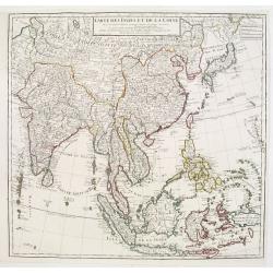
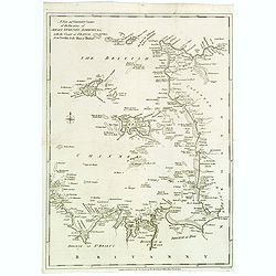
Carte des Indes et de la Chine..
A large and elegant map of the East Indes, India and China.
Date: Paris 1781
Selling price: ????
Please login to see price!
Sold
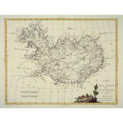
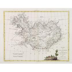
L'Isola d'Icelanda Divisa Ne Suoi Distretti Di nuova Projezione
A very attractive map of Iceland, with a decorative title cartouche to the bottom right hand corner depicting a walled village amongst trees.
Date: Venice, 1781
Selling price: ????
Please login to see price!
Sold
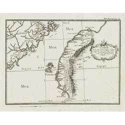
Carte de ce qui appartient a L'Empereur de la Chine dans L'Isle de Formose faite par ordre de L'Empereur Kamhi
Important map of Taiwan extracted from Vol XVIII the 1781 edition of the Jesuit Lettres Edifiantes, illustrating the account of Formosa by the Jesuit Father de Mailla, fi...
Date: Paris, 1781
Selling price: ????
Please login to see price!
Sold
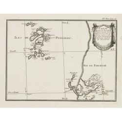
Carte des Isles de PONGHOU suivant le point sur lequel on ete faites les Cartes de la China et de l Tartarie par l'Ordre et aux frais de L'Empereur.
Important map of the Ponghou or Pescadore Islands lying in the Straits of Taiwan and includes details of the environs of Fort Zeelandia on the south-western coast of Taiw...
Date: Paris, 1781
Selling price: ????
Please login to see price!
Sold

Mandarino Chinese. - Mandarin Chinois.
Hand-colored engraving by Teodoro Viero (1740-1819), a famous venetian 18th century artist who engraved and published numerous plates after artists including Tiepolo, Gra...
Date: Venice, ca. 1781
Selling price: ????
Please login to see price!
Sold in 2008
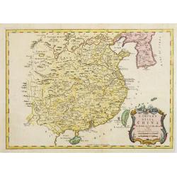
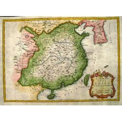
L'Empiro dela China. . .
Attractive map of China with Korea and Taiwan (I.Tay-wan, ou Formosa). Decorative title cartouches in three corners. Uncommon Italian issue. The major towns and cities sh...
Date: Venice, 1781
Selling price: ????
Please login to see price!
Sold in 2008
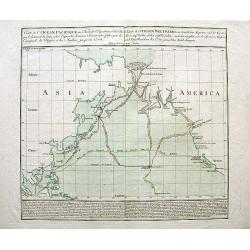
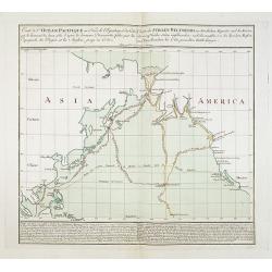
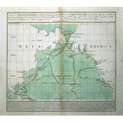
Carte de l'Océan Pacifique au Nord de l'Equateur.../Charte des Stillen Weltmeers...
Highly important map of the northern Pacific Ocean after Thomas Kitchin?s map of 1780. Showing the latest explorations, and the first map to show Cook?s third voyage, and...
Date: Augsburg, 1781
Selling price: ????
Please login to see price!
Sold in 2008
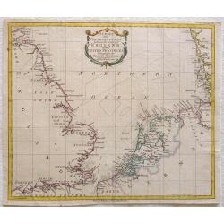
A Chart of the Northern Ocean between the coasts of England and the United Provinces belonging tot the States General
Printed for R. Baldwin at the Rose Pater Noster Row. From London Magazine January 1781. Map of the Noth Sea or Northern Ocean with the coasts of Dorset, Hampshire, Succes...
Date: London, 1781
Selling price: ????
Please login to see price!
Sold in 2013
Carte de l\'Océan Pacifique au Nord de l\'Equateur.../Charte des Stillen Weltmeers...
Highly important map of the northern Pacific Ocean after Thomas Kitchins map of 1780. Showing the latest explorations, and the first map to show Captain Cooks third voy...
Date: Augsburg, 1781
Selling price: ????
Please login to see price!
Sold in 2008
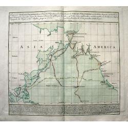
Carte de l'Océan Pacifique au Nord de l'Equateur... / Charte des Stillen Weltmeers. . .
The earliest folio-sized printed map of Cook's third voyage, on which he became the first European to discover Hawaii. On this voyage, he also explored the Northwest coas...
Date: Augsburg, 1781
Selling price: ????
Please login to see price!
Sold in 2018
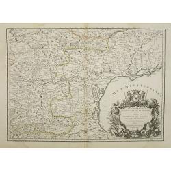
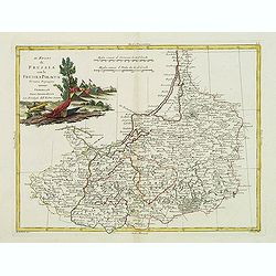
Les Généralitez de Montauban et de Toulouse . . .
Detailed map of the southwest of France, including the towns of Carcassonne, Perpignan, including the Royal Canal.Avec Privilège du Roy.
Date: Paris, 1781
Selling price: ????
Please login to see price!
Sold
L'Isola d'Icelanda Divisa Ne Suoi Distretti Di nuova Projezione.
A very attractive map of Iceland, with a decorative title cartouche to the bottom right hand corner depicting a walled village amongst trees. Published in Zatta's "A...
Date: Venice, 1781
Selling price: ????
Please login to see price!
Sold in 2017
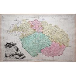
Carte des Etats de Boheme . . .
Louis Brion de la Tour map of Bohemia (Czech Republic), city of Prague is in the center of the map.
Date: Paris, 1781
Selling price: ????
Please login to see price!
Sold in 2010
Carte de l'Océan Pacifique au Nord de l'Equateur.../Charte des Stillen Weltmeers...
Highly important map of the northern Pacific Ocean after Thomas Kitchins map of 1780. Extends from Asia (Siberia to Malaysia), and North America from Alaska to San Blas, ...
Date: Augsburg, 1781
Selling price: ????
Please login to see price!
Sold in 2011
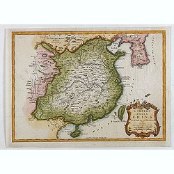
L'Impero Della China.
Uncommon map of China from the Italian version of Bellin's Petit Atlas Maritime.
Date: Venice, 1781
Selling price: ????
Please login to see price!
Sold in 2012
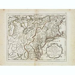
La Virginie, pennsilvanie, Nouvelle Angleterre. . .
Rare map including Virginia, Maryland and Pennsylvania. The map clearly delimits the British Colonies to the regions East of the Alleghany Mountains, based upon the Frenc...
Date: Paris, 1781
Selling price: ????
Please login to see price!
Sold in 2013
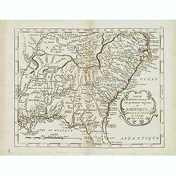
Partie méridionale des possessions Angloises en Amérique. . .
Scarce map of the East coast of North America, as far south as Louisiana and the northern half of Florida. Prepared by Nolin and published by L.J. Mondhare for his Atlas ...
Date: Paris, 1781
Selling price: ????
Please login to see price!
Sold in 2017
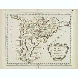
Terre Magellanique le Chili et le Paraguay. . .
Scarce map of southern most South America, prepared by Nolin and published by L.J. Mondhare for his Atlas Général a l'usage des colleges et maisons d'education.. Louis ...
Date: Paris, 1781
Selling price: ????
Please login to see price!
Sold in 2014
![Carte Physique de la Mer Glaciale Arctique ou se voyent les particularites de cetter Mer et le Bassin Terrestre... [Bay of the West]](/uploads/cache/33075-250x250.jpg)
Carte Physique de la Mer Glaciale Arctique ou se voyent les particularites de cetter Mer et le Bassin Terrestre... [Bay of the West]
Scarce seminal map of the Northern Hemisphere after Philippe Buache's map and published by L.J. Mondhare for his Atlas Général a l'usage des colleges et maisons d'educa...
Date: Paris, 1781
Selling price: ????
Please login to see price!
Sold in 2021
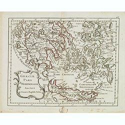
Graeciae pars meridionalis auctore. . .
Rare map of Greece and the most western coastline of Turkey, prepared by Nolin and published by L.J. Mondhare for his Atlas Général a l'usage des colleges et maisons d'...
Date: Paris, 1781
Selling price: ????
Please login to see price!
Sold in 2017
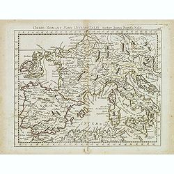
Orbis Romani Pars Ocidentalis. . .
Map of the ancient Roman Empire, prepared by Nolin and published by L.J. Mondhare for his Atlas Général a l'usage des colleges et maisons d'education.. Louis Joseph Mon...
Date: Paris, 1781
Selling price: ????
Please login to see price!
Sold in 2023
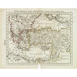
Orbis Romani Pars Orientalis. . .
Unusual map of Ancient Turkey, including a curiously shaped Cyprus, prepared by Nolin and published by L.J. Mondhare for his Atlas Général a l'usage des colleges et mai...
Date: Paris, 1781
Selling price: ????
Please login to see price!
Sold in 2023
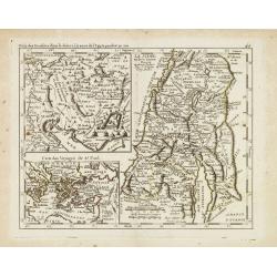
Camp des Israelites dans le désert. . . / La Judée ou Terre Sainte divisée en douze tribus. . . Carte des Voyages de St. Paul.
This antique map shows detailed the Holy Land, prepared by Nolin and published by L.J. Mondhare for his Atlas Général a l'usage des colleges et maisons d'education.. Lo...
Date: Paris, 1781
Selling price: ????
Please login to see price!
Sold in 2013
Plan De l'Isle d'Orléans ou Porto Condore. . .
Plan of New Orleans and it direct environs. From "Lettres Édifiantes et Curieuses. . Missionaires de la Compagnie de Jesus [Jesuit Letters]", 2nd Edition, Tome...
Date: Lyon, J. Vernarel and Et. Cabin et C., 1780/1781
Selling price: ????
Please login to see price!
Sold in 2019
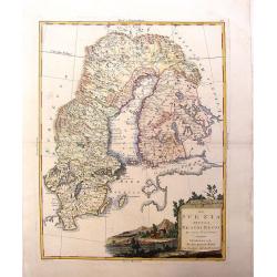
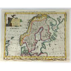
La Svezia Divisa Ne\' Suoi Regni di Nuuva Projezione
A lovely decorative map of Sweden, Finland and Laponia (Lapland). It has a pleasing, scenic title cartouche. Zatta (1775-1797) was the most prominent Italian map publish...
Date: Vienna, 1781
Selling price: ????
Please login to see price!
Sold in 2013
L'Impero Della China.
The map is of interest for the use of Mare di Corea, the sea between Korea and Japan.Attractive and scarce map of China with Korea, Taiwan and Hainan from "Teatro De...
Date: Venice, 1781
Selling price: ????
Please login to see price!
Sold in 2020

Spotted Brown Snake (No Title).
Striking large hand-colored, copper plate of a spotted snake. From Buchoz's book "Histoire Naturelle". Pierre-Joseph Buchoz (1731- 1807) was a French physician,...
Date: Paris, 1781
Selling price: ????
Please login to see price!
Sold in 2016
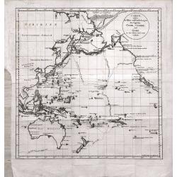
Carte welche die Fahrt und Endeckungen der Capitäns Cook, Clerke und Gore in den Iahren 1776 - 1780 vorstellt
Map of the Pacific Ocean, including Australia and New Zealand, depicting the voyages of Cook, Clerke und Gore during the years 1776 - 1780. From the rare German translati...
Date: Berlin, 1781
Selling price: ????
Please login to see price!
Sold in 2014
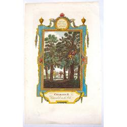
Charles II Concealed in the Oak.
Interesting hand-colored copper engraving from "RUSSELL'S HISTORY OF ENGLAND" in 1781. It was engraved by White after a picture by Wade.
Date: London, 1781
Selling price: ????
Please login to see price!
Sold in 2016
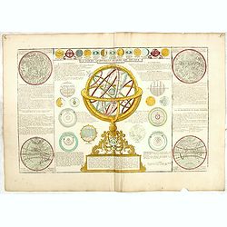
La Sphere Artificielle Ou Armilaire Oblique, elevée sur l'Horizon à la Latitude de Paris.
An attractive scientific plate with a large armillary sphere and is surrounded by two hemisphere maps - the Western showing the Americas with an island California and par...
Date: Paris, ca.1781
Selling price: ????
Please login to see price!
Sold in 2020
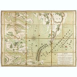
Carte de la partie de la Virginie ou l'armée combinée de France & des Etats-Nies de l'Amérique..
Extremely rare map of the lower Chesapeake Bay emphasizes the Revolutionary War naval battle that took place off the Virginia coast prior to General Charles Cornwalllis's...
Date: Paris, after 1781
Selling price: ????
Please login to see price!
Sold in 2015
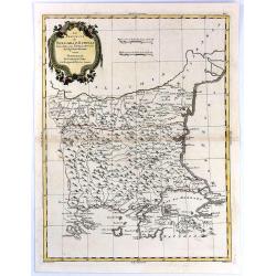
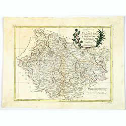
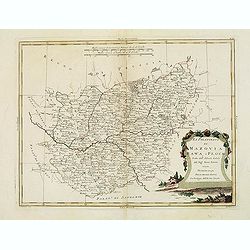
Le Provincie di Bulgaria, e Rumelia Tratte dalla carte dell' Impero Ottomano del Sig Rizzi Zanoni
A copper engraving, in delightful original outline color, featuring both Bulgaria & Romania. A decorative map by the northern Italian cartographer; Antonio Zatta, and...
Date: Venice, 1781
Selling price: ????
Please login to see price!
Sold in 2018
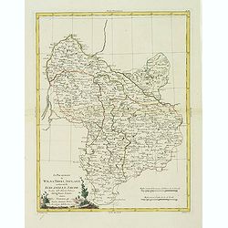
Parte Orientale Dell Elvezia Divisa Ne' Suoi Cantoni.
Parte Orientale Dell Elvezia Divisa Ne' Suoi Cantoni. Eastern Switzerland from Lake Constance (Bodensee) south to Lago Maggiore and Lago di Lugano. Cantons shown: Schaffh...
Date: Venice, 1781
Selling price: ????
Please login to see price!
Sold in 2016

Frontispiece to Anderson's Large Folio Edition of the Whole of Captn Cook's Voyages &c. Complete.
Excellent copper engraved portrait of Captain James Cook set within a decorative frame. With the dates of his three voyages below and with the text line: He was Born at ...
Date: London, 1781
Selling price: ????
Please login to see price!
Sold in 2016
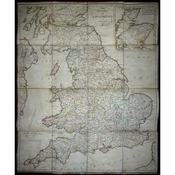
The Roads of Great Britain. Itineraire de la Grande Bretagne. Published as the Act directs Jan 1st 1781 By William Faden Succr to the late T Jefferys Geographer to the King, Charing Cross
A rare example of Faden's desirable folding map 'Roads of Great Britain' in its first edition of 1781.Covering from Scotland to Cornwall, this large pocket map was design...
Date: London, 1781
Selling price: ????
Please login to see price!
Sold in 2017
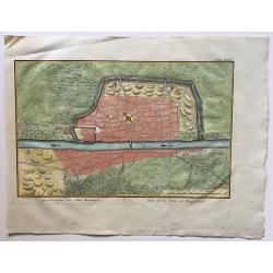
Grontekening der Stad Bagdad.
A rare town plan of Baghdad, Iraq, drawn and engraved by Caspar Jacobsz Philips (1732 – 1789.
Date: Amsterdam, 1781
Selling price: ????
Please login to see price!
Sold in 2016
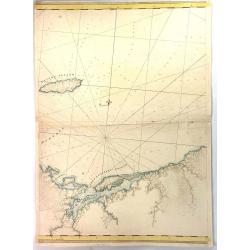
A New and Correct Chart of the Islands of Jersey, Guernsey, Alderney...
A detailed map of the Channel Islands, and sections of Brittany and Normandy, from the Neville to the Isles of Brehat. Included in the Political Magazine , engraved by Lo...
Date: London 1781
Selling price: ????
Please login to see price!
Sold in 2016
![[Untitled chart of Plymouth Bay]](/uploads/cache/39180-250x250.jpg)
[Untitled chart of Plymouth Bay]
Fine chart of Plymouth Bay in Massachusetts, showing the homesteads, roads, and topography in the vicinity of Plymouth. Taken from the "Atlantic Neptune", and m...
Date: London, 1781
Selling price: ????
Please login to see price!
Sold in 2017
Pictou Island & Port Luttrell, Nova Scotia, Canada
A large middle segment of a map featuring Pictou Island, Otter Pond, Duke Point, Port Luttrell or Margomish, Cumberland Beach, and King's Head.Pictou Island is a Canadian...
Date: London, ca 1781
Selling price: ????
Please login to see price!
Sold in 2017
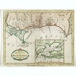
Map of the Province of West Florida. By Tho.s Kitchin.
Scarce map of West Florida, from the May 1781 edition of the London Magazine. Includes a large detailed inset of Pensacola Harbor, including soundings and a not of the st...
Date: London, 1781
Selling price: ????
Please login to see price!
Sold in 2018

Captain James Cook.
Copper engraved portrait of James Cook (1728-1779), published in "A new, authentic, and complete collection of voyages round the world" published in London by A...
Date: London, Alexander Hogg, 1781
Selling price: ????
Please login to see price!
Sold in 2021
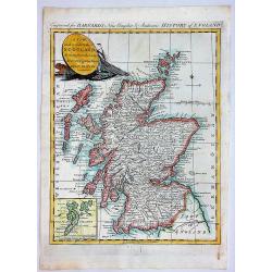
A New and Correct Map of SCOTLAND, Drawn from the Latest Surveys of that Party of Great Britain.
A fine copperplate map from “Barnard's New Complete and Authentic History of England”, published in London by Edward Barnard in 1781-1783.It features a marine cartouc...
Date: London, 1781
Selling price: ????
Please login to see price!
Sold in 2019
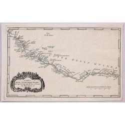
Carta Dell Coste Della Guinea Dal Capo di Verga Sino al Paese d'Issini.
A fine copperplate map of Sierra Leone, including Liberia and the Ivory Coast, from the Italian edition by D’Anville. It features a decorative Rococo cartouche. Jean Ba...
Date: Paris, 1781
Selling price: ????
Please login to see price!
Sold in 2018
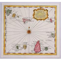
Carta dell Isole di Capo Verde.
A pleasant little map of the Cape Verde Islands off the coast of Africa, by Bellin in Paris dated 1781. This map is from the Italian edition. It features an attractive ti...
Date: Paris, 1781
Selling price: ????
Please login to see price!
Sold in 2017
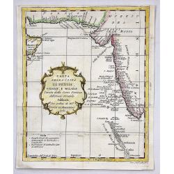
Carta Della Costa di Persia, Guzarat, E Malabar.
A copper engraving by Bellin on the order of Conte Di Maurepas, dated 1781. Published in the Italian edition of the atlas. This interesting map shows a tip of the Arabian...
Date: Paris, 1781
Selling price: ????
Please login to see price!
Sold in 2018
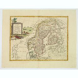
Li Regni di Svezia, Danimarca e Norvegia. . .
Antonio Zatta's detailed map of Sweden, Denmark, Norway and Finland, embellished with a delicately colored title cartouche depicting fishermen hauling in their nets. Show...
Date: Venice, 1781
Selling price: ????
Please login to see price!
Sold in 2019
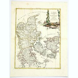
Il Regno di Danimarca con il Ducato di Sleswik. . .
A delicate and finely engraved map of Denmark by Antonio Zatta, published in Venice towards the end of the eighteenth century. The map is enhanced by a delightful title c...
Date: Venice, 1781
Selling price: ????
Please login to see price!
Sold in 2019
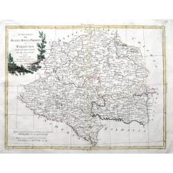
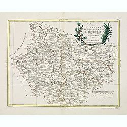
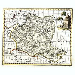
Li Palatinati di Posnania Gniesno, Brzesc, Kalisz e Inowroclaw. . .
An attractive and detailed map of part of Western part of Poland centered on Poznan. The decorative and large pictorial title cartouche is fully colored. Published in Zat...
Date: Venice, 1781
Selling price: ????
Please login to see price!
Sold in 2019
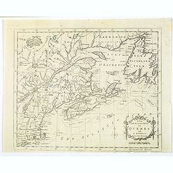
A New and Accurate Mapp of Quebec and its Boundaries, from a late Survey.
A scarce map of the province of Quebec, published in The Universal Magazine in London, September 1781. It shows from Long Island up through New England to Upper and Lower...
Date: London, 1781
Selling price: ????
Please login to see price!
Sold in 2019
Li Palatinati della Russia Rossa Podolia e Wolhynia Tratta dall' Atlante Polaco del Sigr. Rizzi Zanoni.
A very detailed map of the Western Ukraine and a small part of Poland. With the the Voivodeships of Ruthenia, Podole and Volhynia. It includes Ternopil, Lviv, Lublin, Luz...
Date: Venice, ca 1781
Selling price: ????
Please login to see price!
Sold in 2019
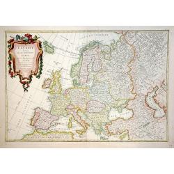
L'Europe divisée en ses principaux Etats.
A beautiful example of Jean Janvier's decorative map of the Europe. Covers from Iceland to the Caspian Sea and from North Africa to the Arctic. Divided into countries and...
Date: Paris, 1782
Selling price: ????
Please login to see price!
Sold in 2012
Governo di Arcangelo, e sue Provincie Nella Russia Europea . . .
Map shows the island Nova Zembla and the government of Archangel, Jarensk and Chlynow. Engraved by G. Zuliani and G. Pitteri.Published in Zatta's 'Atlante Novissimo'. Dec...
Date: Venice, 1782
Selling price: ????
Please login to see price!
Sold in 2012
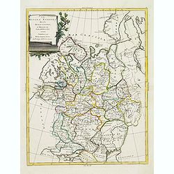
La Russia Europa divisa Ne'suoi Governi e Provincie . . .
An attractive and detailed map of Western Russia with Lapland. Decorative and large pictorial cartouche is fully colored.Published in Zatta's' Atlante Novissimo'. Engrave...
Date: Venice, 1782
Selling price: ????
Please login to see price!
Sold in 2012
Li Palatinati di Posnania, Gniesno, Brzesc, Kalisz, e Inowroclaw. . .
A attractive and detailed map of part of Western part of Poland centered on Poznan. The decorative and large pictorial title cartouche is fully colored.Published in Zatta...
Date: Venice, 1782
Selling price: ????
Please login to see price!
Sold in 2012
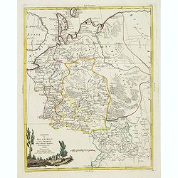
Il Regno di Prussia co la Prussia Polacca. . .
A attractive and detailed map of northern region of Poland including the city of Gdansk on the Baltic coast. The decorative and large pictorial title cartouche is fully c...
Date: Venice, 1782
Selling price: ????
Please login to see price!
Sold in 2012
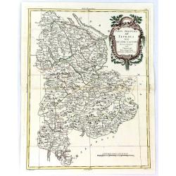
Li Palatinati di Mazovia, Rawa, e Plock, Tratta dall' Atlante Polaco del Sig. . .
A attractive and detailed map of cental Poland including the city of Warsaw. The decorative and large pictorial title cartouche is fully colored.Published in Zatta's' Atl...
Date: Venice, 1782
Selling price: ????
Please login to see price!
Sold in 2012
Li Palatinati di Wilna, Troki, Inflant, coi Ducati di Kurlandia, e Smudz. . .
A attractive and detailed map Latvia and northern Lithuania, marking Vilnius (Wilno), Riga and many other towns.. The decorative and large pictorial title cartouche is fu...
Date: Venice, 1782
Selling price: ????
Please login to see price!
Sold in 2012
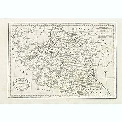
Poland, Shewing the Claims of Austria, Russia & Prussia.
Uncommon map of Poland and Lithuania engraved by J. Cary. Originally published by J.Fielding. Here from the "Complete Geographical Dictionary" by John Seally. T...
Date: London, after 1782
Selling price: ????
Please login to see price!
Sold in 2015
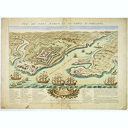
Vue du Port-Mahon et du fort S. Philippe de l'ile Minorque.
A very RARE panoramic of Mahón on Minorca, including a lettered legend in the lower part.The view represents the Fort San Felipe, with its arsenal and batteries, and th...
Date: Paris, ca.1782
Selling price: ????
Please login to see price!
Sold
Li Palatinati di Mazovia, Rawa, e Plock, Tratta dall' Atlante Polaco del Sig. . .
A attractive and detailed map of central Poland including the city of Warsaw. The decorative and large pictorial title cartouche is fully colored.Published in Zatta's' At...
Date: Venice, 1782
Selling price: ????
Please login to see price!
Sold in 2016
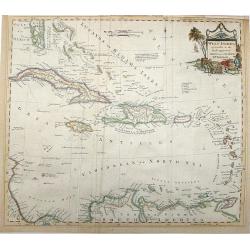
West Indies agreeable to the most approved Maps and Charts .
This highly detailed map shows the Colonial possessions in the West Indies. It covers from Florida, with its southern tip made up of several large islands, through the Ba...
Date: London, 1782
Selling price: ????
Please login to see price!
Sold in 2016
Carte de la Prevoste et Vicomte de Paris.
The large very detailed map of Paris was originally created by Guilliame Deslise or De L'Isle (1675-1726). Delisle is best known for his changes to cartography that resul...
Date: Paris, 1782
Selling price: ????
Please login to see price!
Sold in 2013
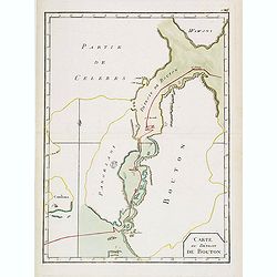
Carte du Détroit de Bouton.
Scarce map of Celebes centered on the Island of Butung. It shows part of Wowoni Island as well as South East Sulawesi.Indicating a V.OC. Settlement on the island Bouton.P...
Date: France, 1782
Selling price: ????
Please login to see price!
Sold in 2021
Plan de la ville et des Ports de Rhodes & Vue du Port des Bateaux a Rhodes.
Two detailed steel engraved prints of Rhodes on one sheet. Features an overhead view of the fortification as well as a view of the ships at port. ByCompte de Choiseul-G...
Date: Paris, 1782
Selling price: ????
Please login to see price!
Sold in 2013
Carte De La Louisiane Et Du Cours Du Mississipi Avec Les Colonies Anglaises. Revue, Corrigee et considerablemt. Augmentee en 1782 . . . Par Guillaume De L'Isle. . .
Unrecorded state of De L'Isle's seminal map, substantially updated with information on the British Colonies at the conclusion of the Revolutionary War.Accurate map showin...
Date: Paris, 1782
Selling price: ????
Please login to see price!
Sold in 2013
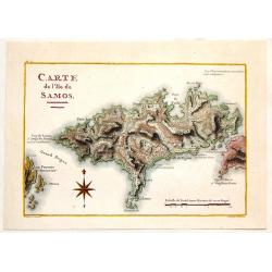
Carte de L\'Ile de Samos.
Fine copper engraved, hand-colored map of the Island of Samos in the Greek Islands. Marie-Gabriel-Florent-Auguste de Choiseul-Gouffier (1752-1817) was a member of the A...
Date: Paris, 1782
Selling price: ????
Please login to see price!
Sold in 2014
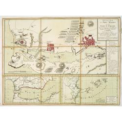
Nouveau Plan du port Mahon et du fort St Philipe Avec les Campements et les différentes Attaques des Troupes Françoises et Espagnoles. . .
A fine map of the Bay of Mahon with a key to the right "Remarques et Renvois du Plan". According to the tittle "Levé sur les Lieux Par les Ingénieurs Mil...
Date: Paris, ca. 1782
Selling price: ????
Please login to see price!
Sold in 2013
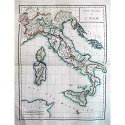
Carte Génerale de l'Italie.
Beautiful copper engraved map of Italy, including Malta, Corsica, and Sardinia. Probably published "Atlas nouveau" by Mentelle. An excellent example of this...
Date: Paris, c. 1782
Selling price: ????
Please login to see price!
Sold in 2013
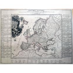
Neue Carte von Europa welche die merkwürdigsten Producte und vornehmsten Handelsplätze...
Rare thematic map showing Europe's economy. It illustrates 56 products and resources, including gold, copper, wine, fruit, salt, hemp, silk, horses, and so on. Nine furth...
Date: Dessau, 1782
Selling price: ????
Please login to see price!
Sold in 2016
Poland Lithuania and Prussia.
Uncommon miniature map of Poland, Lithuania and the Ukraine, engraved by Thomas Kitchin - with his signature in lower right bottom.
Date: London, 1782
Selling price: ????
Please login to see price!
Sold in 2014

The Manner of Burning the Martyrs During the Bloody Teighn of Queen Mary.
Fine hand-colored historical copper engraving featuring martyrs being burnt at the stake. The engraver was Sparrow from a picture by Wale. The engraving comes from "...
Date: London, 1782
Selling price: ????
Please login to see price!
Sold in 2016

King Charles the First After His Retreat From York to Nottingham Ordering the Royal Standard to Be erected On the Castle.
Historical copper engraving featuring King Charles I. The engraver was Taylor after a picture by Wale. The engraving comes from "HISTORY OF ENGLAND" by Raymond...
Date: London, 1782
Selling price: ????
Please login to see price!
Sold in 2017
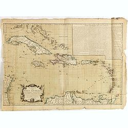
Carte des Isles Antilles dans L'Amerique Septentrionale avec la majeure partie des Isles Lucayes . . . Theatre de la Guerre entre les Anglais et les Americains . . .
Rare Revolutionary War chart of South Florida and the Caribbean, prepared to illustrate a part of the Theatre of War between the English and Americans. With decorative ti...
Date: Paris, Esnauts & Rapilly, 1782
Selling price: ????
Please login to see price!
Sold in 2016
A New And Correct Map Of Norway, Sweden And Denmark. From The Latest Geographical Improvements
An attractive and interesting map, published for George Millar's "New and Universal System of Geography" - a Georgian compendium of reports and accounts from al...
Date: London, 1782
Selling price: ????
Please login to see price!
Sold in 2017
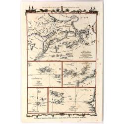
Various Charts of Islands & c, in the Atlantic & Pacific Oceans
This plate shows five groups of islands including the New Northern Archipelago (Aleutian Islands), Azores, Canary Islands, Madeira and Cape Verde. The chart is decorated ...
Date: London, 1782
Selling price: ????
Please login to see price!
Sold in 2016
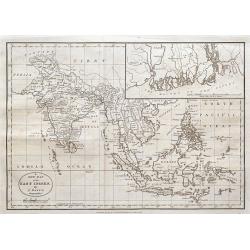
A new map of the East Indies,...
An unusual copper-engraved map of South-East Asia. Extends from Afghanistan to New Guinea and the Philippines, with India, the Gulf of Siam, Sri Lanka or Ceylon, Indonesi...
Date: London, 1782
Selling price: ????
Please login to see price!
Sold in 2016
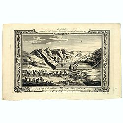
A View of the celebrated Great Wall of China which divides that Empire from Tartary...
A decorative copperplate print of festivities being held at the Great wall in China. The scene is framed within an ornately decorative border. Engraved for Millar's 'New ...
Date: London, ca. 1782
Selling price: ????
Please login to see price!
Sold in 2021
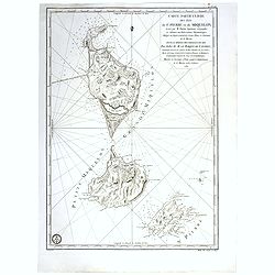
Carte particuliere des isles de St. Pierre et Miquelon Levé par M.Fortin . . . 1782.
Engraved of Saint Pierre and Miquelon, a self-governing territorial overseas collectivity of France, situated in the north-western Atlantic Ocean near the Newfoundland a...
Date: Paris, after 1782
Selling price: ????
Please login to see price!
Sold in 2017
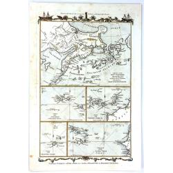
Various Charts of Islands & c in the Atlantic & Pacific Oceans
A fine collage of maps featuring five groups of islands including the New Northern Archipelago (Aleutian Islands), Azores, Canary Islands, Madeira and Cape Verde.The char...
Date: London, 1782
Selling price: ????
Please login to see price!
Sold in 2017
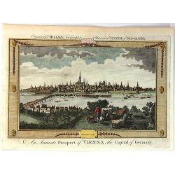
An Accurate Prospect of Vienna, the Capital of Germany.
A fine city view of Vienna, when it was the capital of Germany, not Austria. It is from "Millar's New Complete Universal System of Geography" published in Londo...
Date: London, 1782
Selling price: ????
Please login to see price!
Sold in 2018

