Browse Listings
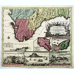
Accurata Designatio Celebris Freti prope Andalusiae Castellum Gibraltar, inter in Europam et Africam, eum circumjacentibus... Portubus, et Castellis cura et impensis. . .
An attractive map by Mattheus Seutter, showing Gibraltar in great detail. With an impressive military style title cartouche, and five beautifully engraved insets of the i...
Date: Augsburg, 1740
Selling price: ????
Please login to see price!
Sold in 2017
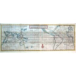
A View of ye General & Coasting Trade-Winds, Monsoons or ye Shifting Trade Winds through ye World, Variations &c.
Curious map of a large part of the world indicating the trade winds. Centered on the Great South Sea. Shows Arabia, Japan, California, north up to Newfoundland. South unt...
Date: London, ca. 1740
Selling price: ????
Please login to see price!
Sold in 2016
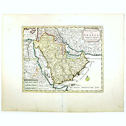
Nieuwe kaart van Arabia.
An attractive map of the Arabian Peninsula here called Gelukkig Arabia or Happy Arabia . The map has a great advance on other maps of the time by showing the true extent ...
Date: Amsterdam, 1740
Selling price: ????
Please login to see price!
Sold in 2016
Nuova Carta del Europa Turchesca.
Isaak Tiron's uncommon map of Asia Minor, Cyprus, Crete, the Black Sea, The Crimea, Greece and the Balkans. Although attributed to Tirion, the map was actually published ...
Date: Venice, 1740
Selling price: ????
Please login to see price!
Sold in 2021
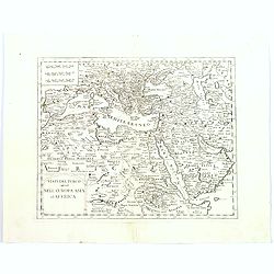
Stati del Turco situati Nell' Europa Asia ed Affrica.
Detailed map of southern Europe, northern eastern Africa, the Arabian peninsular, Turkey and the Balkans, and the Caucasus. Although attributed to Tirion, the map was act...
Date: Venice, 1740
Selling price: ????
Please login to see price!
Sold in 2016
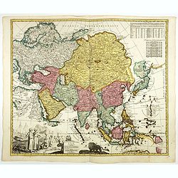
Asia verfertiget von Joh.Schreibern in Leipzig.
Rare map of Asia, from "Atlas Selectus", by Johann Georg Schreiber, a German cartographer and geographer, who was born 1676 and lived in Leipzig. Atlas Selectus...
Date: Leipzig, 1740
Selling price: ????
Please login to see price!
Sold in 2017
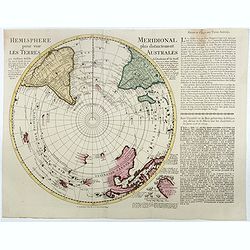
Hemisphere meridional pour voir plus distinctement les terres australes. . .
A Rare Ottens map of the Southern Hemisphere, with an additional text panel pasted to the right side of the map. With the imprint of the Ottens family - rare. The map inc...
Date: Amsterdam, 1740
Selling price: ????
Please login to see price!
Sold in 2016
![Haga Comitum, [Germ. Graven-Haag, Gall. la Haye] sedes ordinum Belgii foederati ichnographica...](/uploads/cache/38667-250x250.jpg)
Haga Comitum, [Germ. Graven-Haag, Gall. la Haye] sedes ordinum Belgii foederati ichnographica...
A beautiful and detailed plan of Den Haag (The Hague), in The Netherlands, with fine striking prospect of the town, as it was in the mid eighteenth century, below the pla...
Date: Nurenberg, ca. 1740
Selling price: ????
Please login to see price!
Sold in 2017
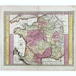
Les routes exactes des Postes du Royaume de France.
post road maps map of France. Seutter the elder (1678-1757) was apprenticed to Johann Baptist Homann in the last years of the seventeenth century in Nuremberg, however, a...
Date: Augsburg, 1740
Selling price: ????
Please login to see price!
Sold in 2016
![Grondvlakte van Nieuw Orleans, de Hoofdstad van Louisiana [with] De Uitloop vande Rivier Missisippi [and] De Oostelyke ingang van de Missisippi met een Plan van het Fort .](/uploads/cache/39133-250x250.jpg)
Grondvlakte van Nieuw Orleans, de Hoofdstad van Louisiana [with] De Uitloop vande Rivier Missisippi [and] De Oostelyke ingang van de Missisippi met een Plan van het Fort .
A sought after, highly attractive, decorative sheet that shows three maps arranged around a large compass rose. This work represents Tirion's version of a map that was fi...
Date: Amsterdam, 1740
Selling price: ????
Please login to see price!
Sold in 2017
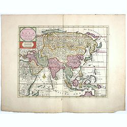
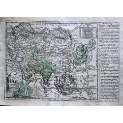
Nieuwe kaart van Asia.
Attractive and detailed map of Asia showing good detail in China, Mongolia, Tibet, Kamchatka, Japan, Kuriles, Korea, Manchuria, Formosa, Philippines, Indonesia Borneo, Ne...
Date: Amsterdam, 1740
Selling price: ????
Please login to see price!
Sold in 2017
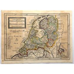
A New Map of the United Provinces of Netherlands.
Detailed map showing towns and cities, rivers, topography and the coastline and canals. An inset at lower right shows Limburg, the southern-most portion of present-day Ne...
Date: London, 1740
Selling price: ????
Please login to see price!
Sold in 2017
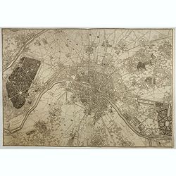
Environs de Paris Levés géométriquement par M. l'Abbé De La Grive. . .
Nine detailed maps of the environs of Paris, including Versailles and Saint-Cloud, each map is on a double sheet with its original centerfold. This remarkable collection ...
Date: Paris, 1740
Selling price: ????
Please login to see price!
Sold in 2017
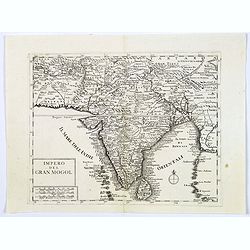
Impero del Gran Mogol.
A very fine map showing India divided into its regions with major towns and cities marked and also parts of its neighbouring kingdoms.
Date: Venice, 1740
Selling price: ????
Please login to see price!
Sold in 2017
Francofurtum ad Moenum - Franckfurt am Mayn.
Decorative town-plan of Frankfurt, with title in Latin and German. The lower part is decorated with a panorama of the city with two vignettes, one representing the empero...
Date: Ausburg, ca. 1740
Selling price: ????
Please login to see price!
Sold in 2017
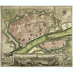
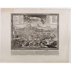
Die kays. Residentz u. Haubt Stadt Wien, nebst den vorstætten in einem accuraten Plan u. Prospect.
Beautiful and rare town-plan of Vienna, accompanied by a panorama of the city in the lower part, showing the buildings from the Löwel Bastei to the Bastey auf der Keller...
Date: Nuremberg, ca. 1740
Selling price: ????
Please login to see price!
Sold in 2017
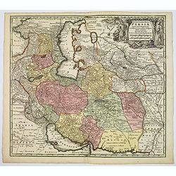
Opulentissimi Regni Persiae.
A very detailed map of the Persian Empire, with a large, decorative title cartouche in upper right corner. Differing colors denote different regions within the map.Seutte...
Date: Augsburg, ca. 1740
Selling price: ????
Please login to see price!
Sold in 2017
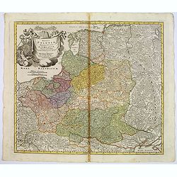
Regni Poloniae magnique ducatus Lithuaniae. . .
A fine map of Poland, Lithuania, Latvia, Estonia, and the western part of Russia, with decorative title cartouche.Johann Baptist Homann was born in Kammlach (1663). He wa...
Date: Nurenberg, 1740
Selling price: ????
Please login to see price!
Sold in 2017
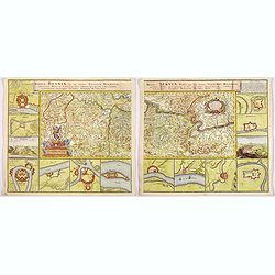
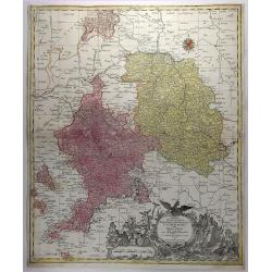
Regnum Bosnia, cum finitimis Croatiae, Dalmatiae. . ./ Regni Serviae pars, una cum finitimis Valechiae and Bulgariae. . .
A lovely pair of maps of Croatia, Dalmatia, and Serbia, Walachia, and part of Bulgaria. The first map 8 small inset maps of Ussitza, Brodt, Wihaz, Zwornek, ratscha, Sabat...
Date: Nuremberg, 1740
Selling price: ????
Please login to see price!
Sold in 2018
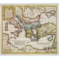
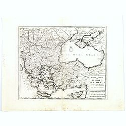
Imperii Turcici Europaei Terra, in primis Graecia. . .
An unusual map showing the Turkish Empire, extending from Corsica and Sardinia in the west, to Asia Minor, Cyprus and the Black Sea in the east. Parts of North Africa als...
Date: Nuremberg, 1740
Selling price: ????
Please login to see price!
Sold in 2017
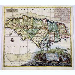
Nova Designatis Insulae Jamaicae ex Antillanis Americae Septentrion. . .
The Caribbean island of Jamaica is shown divided into its various precincts, and there is a large, beautiful title cartouche that shows natives harvesting the various pro...
Date: Augsburg, 1740
Selling price: ????
Please login to see price!
Sold in 2017
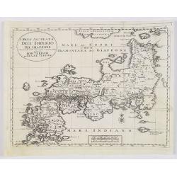
Carta Accurata dell' Imperio del Giappone. . .
Albrizzi published this Italian version of Tirion's map of Japan. In the upper part of the map Jesso of Jesogasima Kamtzchatka is shown north of the Noto Peninsula. At th...
Date: Venice, 1740
Selling price: ????
Please login to see price!
Sold in 2018
Asiae in tabula geographica..opera A.F.Zürner..
A rare map prepared by Adam Friedrich Zürner (1680-1742) with a much oversized Hokkaido and the Philippines. Lower left a decorative title cartouche with eastern merchan...
Date: Amsterdam, 1740
Selling price: ????
Please login to see price!
Sold in 2017

Messina mitt der Neuen Cittadell.
An old birds-eye view of Messina in Sicily. Shows the city from the seaside, with its harbour, fortifications and city walls. Several towers and buildings are shown. With...
Date: Augsburg, ca. 1740
Selling price: ????
Please login to see price!
Sold in 2017
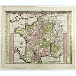
Les routes exactes des Postes du Royaume de France.
post road maps map of France. Seutter the elder (1678-1757) was apprenticed to Johann Baptist Homann in the last years of the seventeenth century in Nuremberg, however, a...
Date: Augsburg, 1740
Selling price: ????
Please login to see price!
Sold in 2017
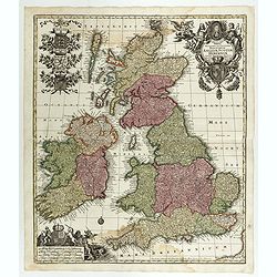
Tabula Novissima Accuratissima Regnorum Angliae, Scotiae, Hiberniae. . .
Decorative map of the British Isles, with 5 large coats of arms, portrait and two large decorative allegorical cartouches. The garlanded cartouche features a portrait of ...
Date: Augsburg, 1740
Selling price: ????
Please login to see price!
Sold in 2018
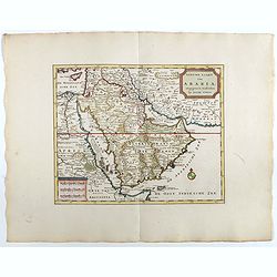
Nieuwe kaart van Arabia.
An attractive map of the Arabian Peninsula here is called Gelukkig Arabia or Happy Arabia . The map has a great advance on other maps of the time by showing the true exte...
Date: Amsterdam, 1740
Selling price: ????
Please login to see price!
Sold in 2025
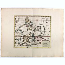
Nieuwe kaart van de Filippynsche, Ladrones, Moluccos of Specery Eilanden als mede Celebes etc.
Shows the western islands of the archipelago, Borneo, Java and Sumatra, up to and including New Guinea. With very good detail to Philippines.Read more Early maps of South...
Date: Amsterdam, 1740
Selling price: ????
Please login to see price!
Sold in 2018
Salisburgum, Salssburg.
Very decorative panoramic view of Saltsburg with an explanation in German and Latin underneath the view. Published by Martin Engelbrecht (1684 - 1756) after a design by F...
Date: Augsburg, 1740
Selling price: ????
Please login to see price!
Sold in 2018
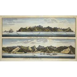
Aussicht der Insel Juan Fernandes/Aussicht von Cumberland Bay.
2 views on one sheet; with decorative views of the coast of Chile by the Admiral of the Fleet George Anson (1697 -1762), who was a Royal Navy officer.
Date: London, ca. 1740
Selling price: ????
Please login to see price!
Sold in 2018

Sr. Francis Drake. Receiving ye Homage & Regalia of ye King of New Albion.
A fine rare copperplate print featuring a portrait of Sir Francis Drake with a telescope in one hand and his other hand on a globe. Below the portrait is an engraving vig...
Date: London, ca. 1740
Selling price: ????
Please login to see price!
Sold in 2018
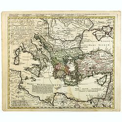
Imperii Turcici Europaei Terra, in primis Graecia. . .
An unusual map showing the Turkish Empire, extending from Corsica and Sardinia in the west, to Asia Minor, Cyprus and the Black Sea in the east. Parts of North Africa als...
Date: Nuremberg, 1740
Selling price: ????
Please login to see price!
Sold in 2020
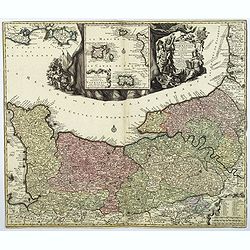
Duche et Gouvernment General de Normandie. . .
A splendid map of Normandy by the German cartographer Seutter, published in the first half of the eighteenth century. Map stretches from Cherbourg in the west, to Alecon ...
Date: Augsburg, ca 1740
Selling price: ????
Please login to see price!
Sold in 2018
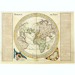
Horizon de Paris. . .
Large circular world map between California, Japan and South- Africa according to a projection centered on Paris, with a diameter of 570mm. Published by André Durand in ...
Date: Paris, 1740
Selling price: ????
Please login to see price!
Sold in 2020
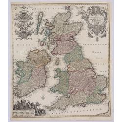
Tabula Accuratissima Regnorum Anglae Scotiae Hiberniae.
A beautiful colored example of Seutter's map of the British Isles, with 5 large coats of arms, portrait and two large decorative allegorical cartouches. One of the most d...
Date: Augsberg, 1740
Selling price: ????
Please login to see price!
Sold in 2019
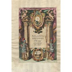
Atlante Novissimo.
Engraved frontispiece from an Italian version of De L’Isle's atlas published by Girolamo Albrizzi. The architectural framework is flanked by male and female Roman soldi...
Date: Venice, 1740
Selling price: ????
Please login to see price!
Sold in 2018
![[2 Maps] Coste Occidentale d'Afrique, Depuis le Xie. Degre. . . / Carte de la Coste Orientale d'Afrique, depuis le Cap de Bonne Esperance. . .](/uploads/cache/42215-250x250.jpg)
[2 Maps] Coste Occidentale d'Afrique, Depuis le Xie. Degre. . . / Carte de la Coste Orientale d'Afrique, depuis le Cap de Bonne Esperance. . .
The first map is a detailed map featuring the southwest coast of Africa from “Cap de Bonne Esperance” (Cape of Good Hope), “Hottentots” (modern South Africa) in t...
Date: Paris, ca 1740
Selling price: ????
Please login to see price!
Sold in 2018
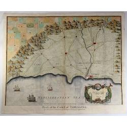
Plan of the Camp of Tarragona.
An interesting map of the Battle of Tarragona in Spain. With a splendid cartouche with Neptune and two sea monsters, and with three detailed ships in the harbour. Paul d...
Date: London, 1740
Selling price: ????
Please login to see price!
Sold in 2019
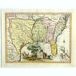
Carta geographica della florida nelp americ settentrionale.
Map taken from "Atlante Novissimo", published by Giambattista Albrizzi around 1740. Based on Delisle, the map covers the region from Filadelfia south to the Bah...
Date: Venise, 1740
Selling price: ????
Please login to see price!
Sold in 2018
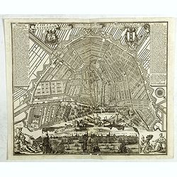
Amsterdam die Weltberuhmte Haupt-und Handel Statt in Holland auf das neuest und accurateste eintworffen und verlegt.
Birds-eye plan view of Amsterdam, depicting the city's architectural landmarks.Matthaus Seutter the elder first published his "Atlas Geographicus" in 1720 and a...
Date: Augsburg, ca. 1740
Selling price: ????
Please login to see price!
Sold in 2018
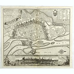
Magdeburgum ducatus cognominis . . .
Birds-eye plan view of Magdeburg.Matthaus Seutter the elder first published his "Atlas Geographicus" in 1720 and added to the contents in subsequent editions un...
Date: Augsburg, ca. 1740
Selling price: ????
Please login to see price!
Sold in 2020
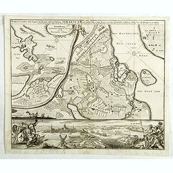
Stetinum celeberima et munitissima Pomeranice Citerioris Metropolis . . .
Birds-eye plan view of Stettin in Poland.Matthaus Seutter the elder first published his "Atlas Geographicus" in 1720 and added to the contents in subsequent edi...
Date: Augsburg, ca. 1740
Selling price: ????
Please login to see price!
Sold in 2018
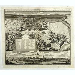
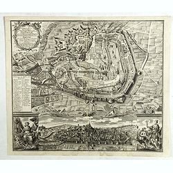
Prospect, Grundris und Gegent der Königl. Schwed. Vestung Stralsund wie solche den 15 July 1715 von den Nordischen Hohen. . .
Detailed battle plan of Stralsund, showing the commencement of the decisive battle of the Siege of Stralsund (1711-1715) on July 15, 1715, with a birds-eye plan view of S...
Date: Augsburg, ca. 1740
Selling price: ????
Please login to see price!
Sold in 2020
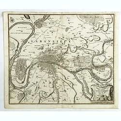
Typus choro-Topographicus regiae et totius Orbis celebrrimae urbis Lutetiae Parisiorum. . .
Map of Paris and its surrounding areas, covering more or less present-day Paris.Matthaus Seµtter the elder first published his "Atlas Geographicus" in 1720 and...
Date: Augsburg, ca. 1740
Selling price: ????
Please login to see price!
Sold in 2021
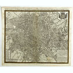
Le plan de Paris et ses Faubourgs et ses environs . . .
Plan of Paris.Matthaus Seutter the elder first published his "Atlas Geographicus" in 1720 and added to the contents in subsequent editions under the title "...
Date: Augsburg, ca. 1740
Selling price: ????
Please login to see price!
Sold in 2018
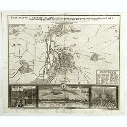
Darstellung des Grundrisses und Prospectes der Königl. Preussisch Magdeburgischen und des Saal-Crayses Haupt Stadt Halle. . .
City plan of Halle with a bird-eye view, the Salt-fountain and the "Auditorium maximum", the largest lecture-room of the university, below.
Date: Augsburg, ca. 1740
Selling price: ????
Please login to see price!
Sold in 2021
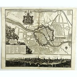
![Haga comitum [Germ Graven-Haag GallLA Haye] . . .](/uploads/cache/42506-250x250.jpg)
Haga comitum [Germ Graven-Haag GallLA Haye] . . .
A beautiful and detailed plan of Den Haag (The Hague), in The Netherlands, with fine striking prospect of the town, as it was in the mid eighteenth century, below the pla...
Date: Augsburg, ca. 1740
Selling price: ????
Please login to see price!
Sold in 2018
Celeberrima ac Spatiossima Thuringiae Metropolis Erfurtum . . .
A beautiful general view and city plan of Erfurt.Matthaus Seutter the elder first published his "Atlas Geographicus" in 1720 and added to the contents in subseq...
Date: Augsburg, ca. 1740
Selling price: ????
Please login to see price!
Sold in 2018
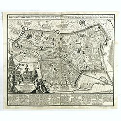
Accurata recens delineatta ichnographia celeberrmae Imperii Civitatis ac Sveviae Metropolis Augustae Vindelicorum . . .
Augsburg city map with a bird-eye view of the city and the main monuments.Matthaus Seutter the elder first published his "Atlas Geographicus" in 1720 and added ...
Date: Augsburg, ca. 1740
Selling price: ????
Please login to see price!
Sold in 2021
Berlin prächtigste und mächtigste Hauptstadt...
Berlin city map with a bird-eye view of the city and the main monuments.Matthaus Seutter the elder first published his "Atlas Geographicus" in 1720 and added to...
Date: Augsburg, ca. 1740
Selling price: ????
Please login to see price!
Sold in 2018
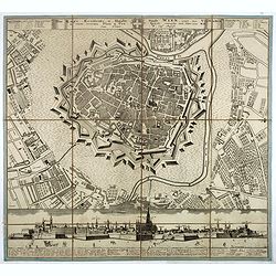
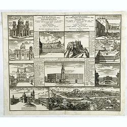
![[Set of 10 bird-eye views of Vienna]](/uploads/cache/42518-250x250.jpg)
[Set of 10 bird-eye views of Vienna]
The famous bird's-eye views of the Vienna suburbs by J. Schachner. Nine bird's-eye views of today's districts 2-9, each with its own, up to 50-piece legend.Matthaus Seutt...
Date: Augsburg, ca. 1740
Selling price: ????
Please login to see price!
Sold in 2018
Prospectus illustriores celeberrimae Archiepiscopalis Urbis Salisburgensis praecipuorumque in ea magnificorum ac admirabilium. . .
Ten views of Salzburg. Matthaus Seutter the elder first published his "Atlas Geographicus" in 1720 and added to the contents in subsequent editions under the ti...
Date: Augsburg, ca. 1740
Selling price: ????
Please login to see price!
Sold in 2021
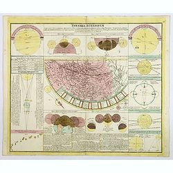
Theoria Eclipsium. . .
This interesting chart provides a comprehensive display of lunar and solar eclipses. The chart is centered on a map depicting the path of the solar eclipse of May 12, 170...
Date: Nuremberg, 1740
Selling price: ????
Please login to see price!
Sold in 2019
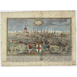
LONDINUM Konden.
A rare and decorative city view of London, England, an engraving after F.B. Werner by J.G. Ringlin published in the “Europäische Städteansichten”, made by Martin En...
Date: Augsburg, ca 1740
Selling price: ????
Please login to see price!
Sold in 2021
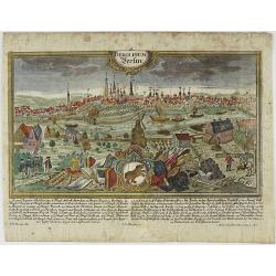
BEROLINUM Berlin.
A rare and decorative city view of Berlin, Germany, an engraving after F.B. Werner by J.G. Ringlin published in the “Europäische Städteansichten”, made by Martin En...
Date: Augsburg, ca 1740
Selling price: ????
Please login to see price!
Sold in 2023
Tabulae Principatus Brandenburgico Culmbacensis Sive Baruthini.
A decorative map of Upper Franconia. The map was prepared by J. A. Riediger. From Graefental to Lauf, from Eger to Lichtenfels. Very large, decorative title cartouche wit...
Date: Augsburg, 1740
Selling price: ????
Please login to see price!
Sold in 2019
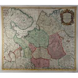
Mappae Imperii Moscovitici . . .
An ORIGINAL 18th century copperplate engraved map by De L'isle. Published in Augsburg by M. Seutter. NICELY detailed and beautifully engraved. Archangel is just left of c...
Date: Augsberg, 1740
Selling price: ????
Please login to see price!
Sold in 2019
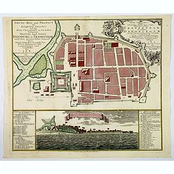
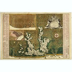
Grund=Riss und Prospect der Koniglichen Danischen auf der Kuste Choromandel in Ost-Indien belegenen Vestung und Stadt Dansburg u Trankenbar . . .
The Danish East India Company was founded in 1616. A first expedition was sent out in November 1618, which led to the purchase of a parcel of land on the Coromandel coast...
Date: Augsburg ca 1740
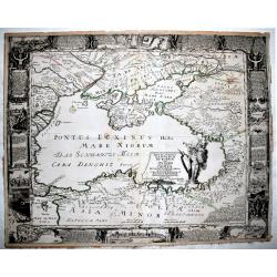
Nova et accurata Tartariae Europae. . . Crimeae. . .
An extremely rare, very large carte-a-figure map of the Black Sea area. With decorative title cartouche and surrounded by four borders with 10 city views, each accompanie...
Date: Augsburg, 1740
Selling price: ????
Please login to see price!
Sold in 2019
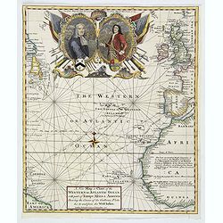
A New Map or Chart of The Western or Atlantic Ocean with Part of Europe, Africa & America: Shewing the Course of the Galleons. . .
An attractive chart of the Atlantic Ocean with large decorative cartouche, from 'The Gentleman's Magazine: and Historical Chronicle', by Sylvanus Urban, printed by Edward...
Date: London, 1740
Selling price: ????
Please login to see price!
Sold in 2019
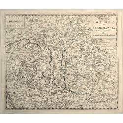
Nuovo Carta del Regno di Ungheria e Della Transilvania...
Detailed map of Hungary and Romania including hundreds of tiny villages. Title in block style.Copied after Isaak Tirion (1705 – 1765).
Date: Venice, 1740
Selling price: ????
Please login to see price!
Sold in 2019
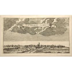
La Citta di Strasburgo o Sia Argentina.
Fine city view engraving of Strasburg, France by Thomas Salmon. Published in Rome by Giambattista Albrizzi in 1740.Giambattita Albrizzi was a famous Venetian publisher an...
Date: Venice, 1740
Selling price: ????
Please login to see price!
Sold in 2023
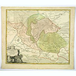
Comitatus Stolbergici ad Hercyniam. . .
The County of Stolberg (Grafschaft Stolberg) was a county of the Holy Roman Empire located in the Harz mountain range in present-day Saxony-Anhalt, Germany. It was ruled ...
Date: Nuremberg, ca 1740
Selling price: ????
Please login to see price!
Sold in 2021
Algemene kaart van Suriname Algemeene kaart van de Colonie of Provintie van Suriname : met de rivieren, districten, ontdekkingen door militaire togten. . .
Uncommon large scale map of of Suriname, indicating the different plantations and their owners. Consists of two glued-together sheets. Completed with funding by the Direc...
Date: Amsterdam, 1740
Selling price: ????
Please login to see price!
Sold in 2023
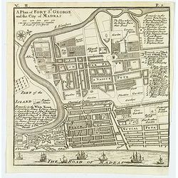
A Plan of Fort St. George and the City of Madras.
A detailed plan of the famous Fort St. George and the city of Madras (now Chennai). The fort was the first British fortification in India, built in 1639 and it still stan...
Date: London, ca 1740
Selling price: ????
Please login to see price!
Sold in 2020
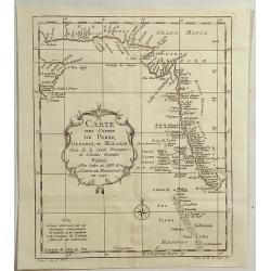
Carte Des Costes de Perse, Gusarat, et Malabar.
An interesting map of the Persian Gulf, Iran and Western India including the Maldives Islands. Featuring a decorative cartouche. Jacques Nicolas Bellin (1703-1772) was on...
Date: Paris, 1740
Selling price: ????
Please login to see price!
Sold in 2019
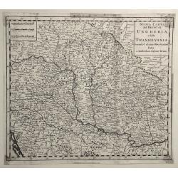
Nuovo Carta del Regno di Ungheria, e della Transilvania ...
Detailed map of Hungary, Slovenia, Transylvania, and parts of Croatia, Bosnia, Serbia, Romania and Bulgaria, from an Italian edition of Thomas Salmon's , “Modern Histor...
Date: Venice, 1740
Selling price: ????
Please login to see price!
Sold in 2019
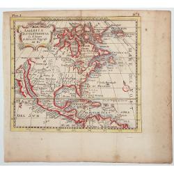
AMERICA SETTENTRIONAL di N. Sanson (California Island)
Very rare old outline color example of Nicolas Sanson's map of North America. California is depicted as an island; McLaughlin notes: "California with indented northe...
Date: NAPLES, ca 1740
Selling price: ????
Please login to see price!
Sold in 2020
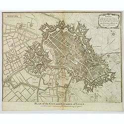
Plan of the City and Citadel of Lisle.
An elaborate bird's-eye view of the fortifications and city of the northern French town of Lisle, and the surrounding countryside. With fortifications shown in great deta...
Date: London, 1740
Selling price: ????
Please login to see price!
Sold in 2020
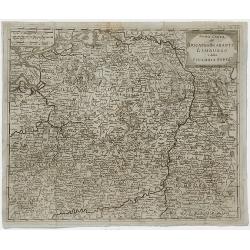
Nuova Carta del Ducato di Brabante Limburgo e della Gheldria Superre.
A fine map of the Duchy of Brabant and Limburg, Germany that appeared in "Novissimo Atlas published by Giovanni Albrizzi, a work based on the work of Isaak Tirion. I...
Date: Venice, 1740
Selling price: ????
Please login to see price!
Sold in 2020
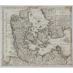
Carta Nuovo del Regno di Danimarca.
A detailed map of Denmark and the southern part of Sweden. With title in block style.The map appeared in "Novissimo Atlas published by Giovanni Albrizzi, a work base...
Date: Venice, 1740
Selling price: ????
Please login to see price!
Sold in 2021
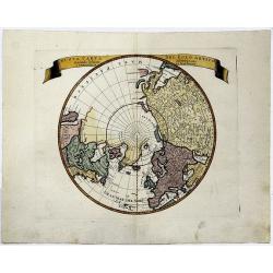
NUOAVA CARTA DEL POLO ARTICO. . . (California as an Island)
A colored, decorative map of the Northern Hemisphere and the North Pole, which shows the possibility of the Northeast Passage, but no definite Northwest Passage.
Date: Venice, 1740
Selling price: ????
Please login to see price!
Sold in 2019
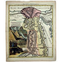
AEGYPTUS HODIERNA.
A scarce and splendid map of ancient Egypt. West is at the top and the Nile bisects Egypt. A small inset shows the region around Alexandria to good detail. With the Red S...
Date: Nurenberg, 1740
Selling price: ????
Please login to see price!
Sold in 2020
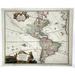
Totius AMERICAE Septentrionalis et Meridionalis novissima represestatio quam ex fingulis. . .
A richly ornamented map of North and South America. Title cartouche bottom left is copied from De Fer's map of 1699 and the cartouche containing text (top left) is based ...
Date: Nuremberg, 1740
Selling price: ????
Please login to see price!
Sold in 2020
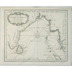
Carte du Golphe de Bengale Tire de l'Ocean Oriental.
Bellin's detailed regional map of the Gulf of Bengal and the lower Ganges River. t features a decorative cartouche and a large compass rose in the centre.Jacques-Nicolas...
Date: Paris, 1740
Selling price: ????
Please login to see price!
Sold in 2020
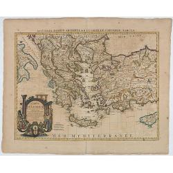
Carte de la Grece.(Accurata Totius Archipelagi et Greciae ...
The map was originally issued by G.de L'Isle.
Date: Amsterdam, 1740
Selling price: ????
Please login to see price!
Sold in 2020
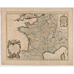
La France Dressée sur un grand nombre de Cartes particulières manuscrites ou imprimées levées sur les lieux et conférées avec les Itinéraires
Decorative map of France prepared by G. de l'Isle and re-issued by Covens and Mortier.
Date: Amsterdam, ca. 1740
Selling price: ????
Please login to see price!
Sold in 2020
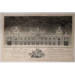
Vue et Dessein de l'Illumination.
A view and design of the Illumination of the hotel Nesle in Paris, by the artist Jean Antoine Belmond (Italian, 1696–1775) after François Boucher (French, 1703–1770)...
Date: Paris, 1740
Selling price: ????
Please login to see price!
Sold in 2020
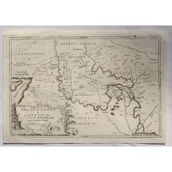
Mesopotamia E Babilonia Coifmi Delineati Secondovna.
A fine copperplate map of current-day Armenia, Syria, Cyprus & Iraq. An Italian edition by Cellarius in 1740. It features a decorative cartouches including building...
Date: Amsterdam, 1740
Selling price: ????
Please login to see price!
Sold in 2023
Isola Ceilon.
Attractive copper engraved map of Sri Lanka showing mountains, Towns and the Rama's Bridge (Ponte di Adamo). Included in "Atlante Novissimo che Contiene Tutte le Par...
Date: Venice, 1740
Selling price: ????
Please login to see price!
Sold in 2020