Browse Listings
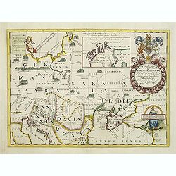
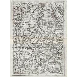
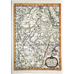
A new map of Sarmatia Europaea Pannonia and Dacia. . .
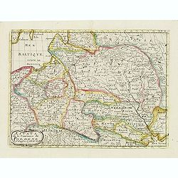
Decorative map of the region between the Baltic, Adriatic and Black Seas. This decorative map was part of a set of 22 maps dedicated to William, Duke of Gloucester, who w...
Date: Oxford, 1700
Selling price: ????
Please login to see price!
Sold in 2011
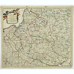
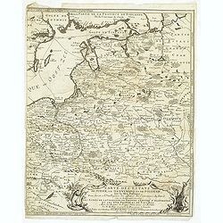
Regni Poloniae et Ducatus Lithuaniae Voliniae..
Rare map issued by Justus Danckerts attractive map of Poland and Lithuania.Decorative title cartouche upper left hand corner.The map has strong original coloring, the tit...
Date: Amsterdam, 1700
Selling price: ????
Please login to see price!
Sold in 2011
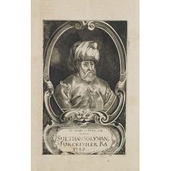
Sulthan Solyman Turckischer Kayser.
Portrait of Kanuni Sultan Süleyman (6 November 1494 – 5/6/7 September 1566) was the tenth and longest-reigning Sultan of the Ottoman Empire, from 1520 to his death in ...
Date: Germany, c. 1700
Selling price: ????
Please login to see price!
Sold in 2011
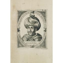
Turckischer Keyser Sultan Mahumet III und XV Osmaniers geschlechts und stammes.
Portrait of Sultan Mahumet III who was born on the 30th of December in 1673. He was intelligent and educated by famous scholars.Sultan Ahmed III acceded the throne after ...
Date: Germany, c.1700
Selling price: ????
Please login to see price!
Sold in 2011
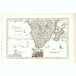
Partie de la Haute Aethiopie ...
Map of the East coast of Africa. From Description de tout l'Univers, published by François Halma.
Date: Amsterdam, 1700
Selling price: ????
Please login to see price!
Sold in 2011
Afrique ou Libie Ulterieure ou sont le Saara ou Desert, ...
Map of the Ivory Coast. From Description de tout l'Univers, published by François Halma.
Date: Amsterdam, 1700
Selling price: ????
Please login to see price!
Sold in 2011
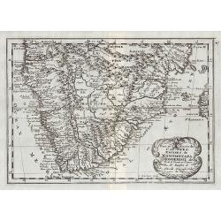
Pays, et Coste des Caffres : Empires de Monomatapa Monoemugi, &c.
Map of southern Africa. From Description de tout l'Univers, published by François Halma.
Date: Amsterdam, 1700
Selling price: ????
Please login to see price!
Sold in 2011
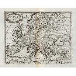
Europe.
General map of Europe. From Description de tout l'Univers, published by François Halma.
Date: Amsterdam, 1700
Selling price: ????
Please login to see price!
Sold in 2011
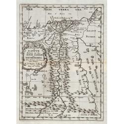
Egypte divisée en ses Douze Cassilifs, ...
Map of Egypt. From Description de tout l'Univers, published by François Halma.
Date: Amsterdam, 1700
Selling price: ????
Please login to see price!
Sold in 2012
Partie de la HAUTE AETHIOPIE ou sont L'EMPIRE des ABISSINS et la NUBIE &c.
An excellent map of the Nile with its mythical sources. Shows the Nile River from Zaire Lake and Zaflant Lake, until Assuan / Aswan). Richly detailed with place names, hi...
Date: Paris, ca 1700
Selling price: ????
Please login to see price!
Sold in 2019
![Cette Carte DE CALIFORNIE et DU NOUVEAU MEXIQUE.[Rare 1st edition!]](/uploads/cache/83264-250x250.jpg)
Cette Carte DE CALIFORNIE et DU NOUVEAU MEXIQUE.[Rare 1st edition!]
Rare and important map of California ,New Mexico and New Spain, showing in detail California as an island [San Francisco, San Diego and Mendocino are mentioned among many...
Date: Paris 1700
Selling price: ????
Please login to see price!
Sold in 2021
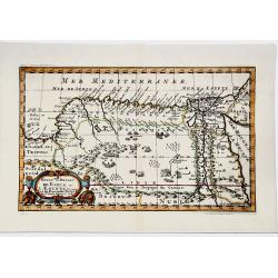
ROYAUME et Desert De BARCE, et L'AEGYPTE divisee en ses Principales Parties.
Very fine, decorative map of Egypt prepared by N.Sanson. Engraved by A.de Winter.
Date: Paris, 1700
Selling price: ????
Please login to see price!
Sold in 2019
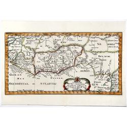
LA GUINEE et Pays circonvoisins.
Attractive copper engraved map of the Guinea coast including Guinea, Benin and Congo. Nicely detailed and decorated with a title cartouche that credits Gerard Mercator an...
Date: Amsterdam 1700
Selling price: ????
Please login to see price!
Sold in 2019
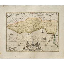
Guinea.
A decorative map of West Africa. The map includes numerous animals in the interior, sailing ships and an elegant cartouche. Published in Amsterdam by P. Schenk and G. Val...
Date: Amsterdam, ca. 1700
Selling price: ????
Please login to see price!
Sold in 2019
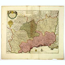
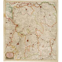
Gouvernement General de Languedoc. Divise en ses Vint Deux Diocesez.
A lovely late seventeenth century map of the central south French region of Languedoc, part of which borders the Mediterranean Sea by Dutch publisher and cartographer, Fr...
Date: Amsterdam, ca 1700
Selling price: ????
Please login to see price!
Sold in 2019
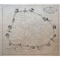
Hanc VIENNAE Quam vides Geometricam faciem Archimedem Siracusanum, Augustinus Hirsfogel a suo depictam radio imitatus est Anno. 1552.
Rare copper engraving of the circular plan of Vienna with its bastions, walls and wall towers, and gates. It shows the fortress Vienna after thoroughly modernizing its de...
Date: Vienna, around 1700
Selling price: ????
Please login to see price!
Sold in 2019
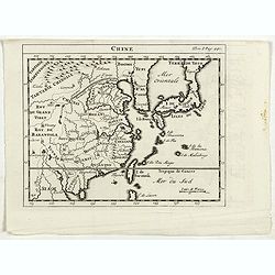
Chine.
RARE miniature map of China, Korea, Japan and Taiwan. The map is of interest for the use of East Sea, the sea between Korea and Japan, here called "Mer Orientale&quo...
Date: Paris, ca. 1700
Selling price: ????
Please login to see price!
Sold in 2023
![GEOGRAPHISCHE UNIVERSAL-ZEIG UND SCHLAG-UHR.[Rare first edition]](/uploads/cache/83574-250x250.jpg)
GEOGRAPHISCHE UNIVERSAL-ZEIG UND SCHLAG-UHR.[Rare first edition]
A map of the Northern Hemisphere showing California as an Island. Inspired by the German clockmaker Zacharias Landteck. The map is placed within an engraved table case cl...
Date: Nuremberg, ca 1700
Selling price: ????
Please login to see price!
Sold in 2020
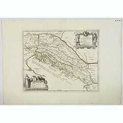
Veteris Pannonia utriusque nec non Illyrici descriptio Geographica . . .
A delightful map of the ancient Dalmatian coastline, that includes parts of modern day Austria, Hungary and Croatia, engraved by Joseph Thoal, and printed at the Seminary...
Date: Padua, ca 1700
Selling price: ????
Please login to see price!
Sold in 2023
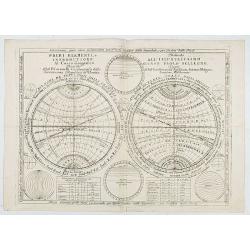
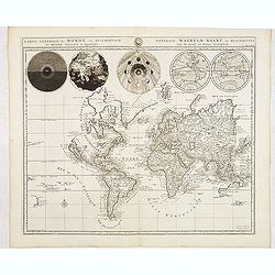
Primi Elementi, o introductione al Corso Geografico..
An introduction to geography, with a double hemisphere, spheres of longitude and latitude and distance tables, showing equator, climate zones, etc. Several smaller diagra...
Date: Venice, 1700
Selling price: ????
Please login to see price!
Sold in 2020
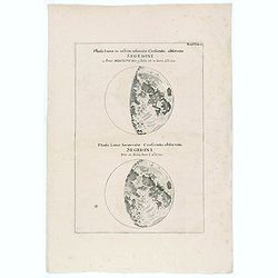
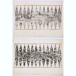
Phasis Lunae in orbem insinuatae Crescentis, observata Segedini Anno MDCXCVI Die 9. Julii st. N. hor.i. a Oocc.
Two moon projections on one sheet according to J. Hevelius.
Date: ca. 1700
Selling price: ????
Please login to see price!
Sold in 2020
Carte Particuliere des Costes de l ' Afrique depuis Cabo Ledi jusques au Cap de Bone Esperance.
Carte Particuliere des Costes de l ' Afrique depuis Cabo Ledi jusques au Cap de Bone Esperance. Pieter Mortier (1661-1711), Amsterdam bookseller and printer of French des...
Date: Amsterdam, 1700
Selling price: ????
Please login to see price!
Sold in 2020
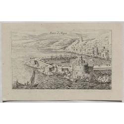
Port d'Alger.
A fine copper engraved city view of Algiers, in Algeria from about 1700.
Date: Paris, ca 1700
Selling price: ????
Please login to see price!
Sold in 2020
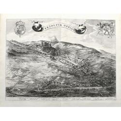
Verzolium Oppidum.
A large birds-eye view of the town of Verzuolo. The town lies between Cuneo and Torino. Superbly engraved with numerous houses, a monastery, and the general landscape. A ...
Date: Amsterdam, ca 1700
Selling price: ????
Please login to see price!
Sold in 2021
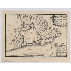
Plan du Chasteau de Dinant.
A plan of the castle of Dinant in Belgium, showing the fortifications. It features a ribbon decorative cartouche, and a detailed table of key places.
Date: Paris, ca 1700
Selling price: ????
Please login to see price!
Sold in 2020
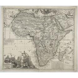
Africae in Tabula Geographica Delineatio.
An attractive and detailed map of Africa, drawn by Zurner and published by Pieter Schenk. It's an updated version of the previous Schenk map, which was based on Visscher....
Date: Amsterdam, ca 1700
Selling price: ????
Please login to see price!
Sold in 2020
Africae Pars Australis.
Africa south of the equator. Beautiful cartouche with the title above in a scroll. Nice margins, excellent condition.
Date: Munich, 1700
Selling price: ????
Please login to see price!
Sold in 2020
Hos Globos Terracqueum, ac Coelestem Dicat. . .
A very rare pair of 15 cm (6 inch) globe gores.Two sets of 12 gores on 2 sheets for a pair of terrestial and celestial globes. Terrestria: California as an island, Terra ...
Date: Venice, 1700
Selling price: ????
Please login to see price!
Sold in 2020
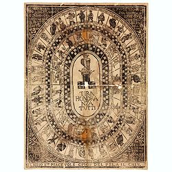
Tira Honoranza Tutti.
Game of the Goose board with four concentric ovals containing squares with dice, human figures or owls, in the center a crowned owl atop a crown resting on three dice sho...
Date: Lucca, ca 1700
Selling price: ????
Please login to see price!
Sold in 2020
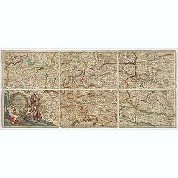
Carver's new map of North America. . .
6 maps on a sheet Carver's map of North America, among other maps of Strait Anian.
Date: England, ca. 1700
Selling price: ????
Please login to see price!
Sold in 2020
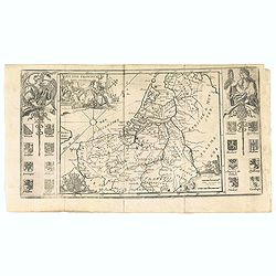
Les XVII Provincies des Pais Bas.
Map of the Netherlands, with coats of arms.
Date: Amsterdam, 1700
Selling price: ????
Please login to see price!
Sold in 2020
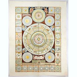
Idea dell'Universo.
This is a set of diagrams relating to astronomy and astrology, with wind head borders. The subjects include a perpetual calendar, the zodiac, the parts of the body domina...
Date: Venice, c. 1700
Selling price: ????
Please login to see price!
Sold in 2021
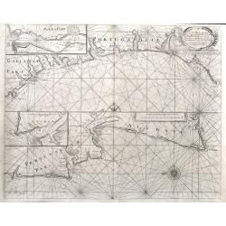
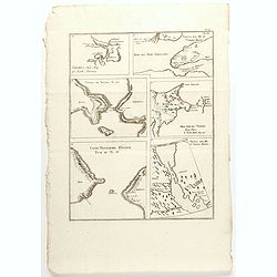
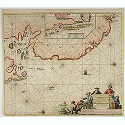
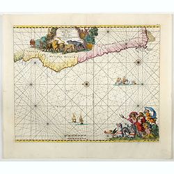
A Sea Chart of part of the Coasts of Gallisia and Portugall from Capo do Finisterre...
An unusual sea-chart of Portugal, two parts on one sheet. The top part is from Villa Nova until Peniche, the bottom part from Peniche until Lagos in the Algarve. Includes...
Date: London, ca 1700
Selling price: ????
Please login to see price!
Sold in 2021
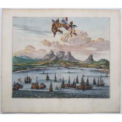
LE CAP DE BONNE ESPERANCE.
Probably the finest view of Cape Town. Beautifully engraved. A sea battle in the foreground with at least 15 galleons.With Tabletop mountain as the backdrop. Two putti ho...
Date: Leiden, ca 1700
Selling price: ????
Please login to see price!
Sold in 2021
![[Lot of 9 maps / prints of SOUTH AFRICA] Carte du Congo et du Pays des Cafres.](/uploads/cache/19581-(1)-250x250.jpg)
[Lot of 9 maps / prints of SOUTH AFRICA] Carte du Congo et du Pays des Cafres.
Guillaume de l 'Isle's influential map of South Africa. Guillaume de l' Isle (1675-1724), Royal Geographer, was the most influential cartographer of the first quarter of ...
Date: Paris, c. 1700
Selling price: ????
Please login to see price!
Sold in 2022
Pas-Kaert van de Cust van Noorwegen Beginnende van Der Neus tot aen Bommel Sond.
Very decorative sea chart of Norway by J. Van Keulen, shows VVest Agder and Rogaland, oriented to the East. Plate number 12 in lower right corner.Inset chart: Pascaertie ...
Date: Amsterdam, 1700
Selling price: ????
Please login to see price!
Sold in 2022
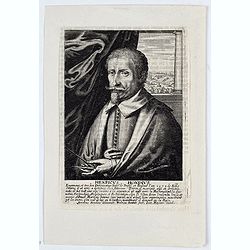
Henricus Hondius.
Portrait of Henricus Hondius. Fredericus Bouttats fecit, Ioan Meyssens excud.
Date: Antwerpen, 1700
Selling price: ????
Please login to see price!
Sold in 2023
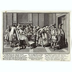
Sanitati et Voluptati inservientes herbae thee et caffe.
Copper-plate engraving showing a group of fashionably dressed men and women, drinking tea or coffee. "Paulus Decker inv. et del.; Ioh. Christoph Steudner sculp.; Mar...
Date: Augsburg, 1700
Selling price: ????
Please login to see price!
Sold in 2024
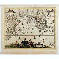
Nova Tabula Indiae Orientalis.
Covers an area from the Cape of Good Hope to Japan, including the East Indies, and Australia as discovered by Tasman lettered Nova Hollandia, Terradel Zur . An unchanged ...
Date: Amsterdam, 1700
Selling price: ????
Please login to see price!
Sold in 2023
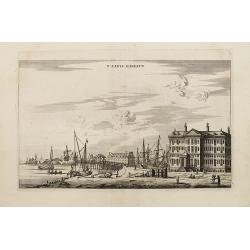
T' LANTS MAGESYN.
A decorative print of the 'T Landts Magazyn of the V.O.C. now-a-days the Maritime Museum.
Date: Amsterdam, 1700
Selling price: ????
Please login to see price!
Sold in 2023
Cimbebas et Caffariae Littora a Catenbela ad Promontorium ..
A delightful Dutch sea chart that shows the coast of Angola, south-west Africa and South Africa up to Port Elizabeth. A truly classic sea chart of Dutch school with excel...
Date: Amsterdam, 1700
Selling price: ????
Please login to see price!
Sold in 2023
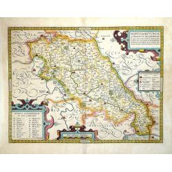
Northamptoniae Comitatus Descriptio.
This rare and important map is one of a series of county maps attributed to William Smith the antiquarian, each lacking the cartographer's name and consequently often ref...
Date: London, 1700
Selling price: ????
Please login to see price!
Sold in 2013
Regni Poloniae et Ducatus Lithuaniae Voliniae. . .
Rare issue of Justus Danckerts attractive map of Poland and Lithuania.Decorative title cartouche upper left hand corner.The map has strong original coloring, the titles f...
Date: Amsterdam, 1700
Selling price: ????
Please login to see price!
Sold in 2013
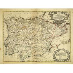
La Espana Dedicata all Ill Ed Ecc Sig. D. Carmine Niccolo Caracciolo. . .
Rare map of Spain and Portugal. Engraved by Andrea Magliar and published by Paolo Petrini. Based on a map of Nicholas De Fer.This is the first edition of the map, which i...
Date: Naples, 1700
Selling price: ????
Please login to see price!
Sold in 2013
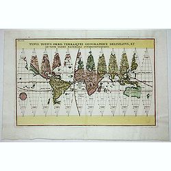
Typus Totius Orbis Terraquei Geographice Delineatus.
Finely engraved set of 12 globe gores. Fascinating Northwest Passage treatment. Excellent detail in Australia and a nice bit of New Zealand shown, along with a curious ov...
Date: Munich, 1700
Selling price: ????
Please login to see price!
Sold in 2014
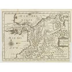
Terre Ferme et Nouv. Royaume de Grenade et Popaian.
Charming and uncommon map of today territory of Colombia. Decorated with a compass rose and title cartouche.
Date: Amsterdam, 1700
Selling price: ????
Please login to see price!
Sold in 2015
Cartes des pays et des peuples du Cap de bonne Esperance nouvellemt decouverts par les Hollandois.
French manuscript map of Cape of Good Hope, as it was at about 1670. With a key (A-C) pointing to the Dutch fortress, Table Mountain and Lion's head.
Date: France, ca. 1670-1700
Selling price: ????
Please login to see price!
Sold in 2012
Les Etats de la couronne de Pologne.
Fine map of Poland, engraved by A. de Winter for "Description de tout L'Univers en plusieurs cartes, & en divers traitez de Geographie et d'Histoire. . .".
Date: Amsterdam, F.Halma, 1700
Selling price: ????
Please login to see price!
Sold in 2012
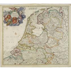
Belgium foederatum emendatius auctum. . .
Rare issue of Justus Danckert's attractive map of present-day The Netherlands.Decorative title cartouche upper left hand corner.
Date: Amsterdam, 1700
Selling price: ????
Please login to see price!
Sold in 2022

Ultraiectini dominii tabula.
Rare issue of Justus Danckert's attractive map of the province of Utrecht. Shows the land development in Utrecht, Holland, near the Zuyder Zee and it shows Utrecht, Amers...
Date: Amsterdam, 1700
Selling price: ????
Please login to see price!
Sold in 2012
Ducatus Brabantiae tabula continens sacri imperii. . .
Rare issue of Cornelis Danckert's attractive map of Brabant.Decorative title cartouche lower left hand corner.
Date: Amsterdam, 1700
Selling price: ????
Please login to see price!
Sold in 2023
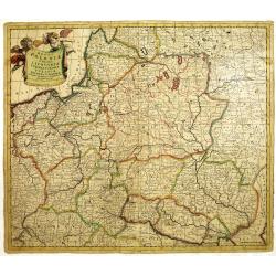
Carte des Etats de Suede, de Dannemarq, et de Pologne sur le Mer Batlique. . .
Map covers Poland and Lithuania. Decorative title cartouche supported by a bear and a wild horse in lower right corner.In itself complete, but the right sheet, only, of a...
Date: Paris, 1700
Selling price: ????
Please login to see price!
Sold in 2012
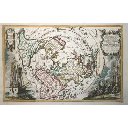
Repraesentatio Geographica Itineris Maritimi Navis Victoriae..
This very graphic map of the world is presented on a north polar projection and depicting all of the world except the South Pole. California is shown as an island and the...
Date: Munich, ca. 1700
Selling price: ????
Please login to see price!
Sold in 2012
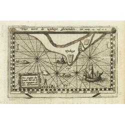
Waer wort de wysheyt ghevonden. . ./ Den omganc des hemels heb ick alleen omgegaen en dien doorwandelt.
Small map of an imaginary Land of Wisdom according to Job 28 "Where Can Wisdom Be Found". The map is surrounded with quotes from the bible and inside we see the...
Date: Netherlands, ca. 1700
Selling price: ????
Please login to see price!
Sold in 2012
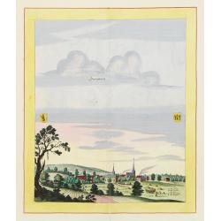
Sonnenburch
Very decorative and rare panoramic of Sonnenburg near Küstrin .The engraver and publisher of prints, Mrs. Anna Beek of the Hague, enlarged the print and mounted it on l...
Date: The Hague 1700
Selling price: ????
Please login to see price!
Sold in 2012
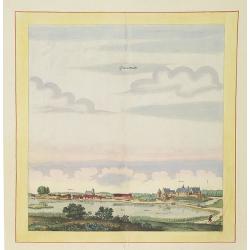
Liebenwalde.
Very decorative and rare panoramic of Liebenwalde a.d. Olse, Schlesien .The engraver and publisher of prints, Mrs. Anna Beek of the Hague, enlarged the print and mounted...
Date: The Hague, ca. 1700
Selling price: ????
Please login to see price!
Sold in 2012
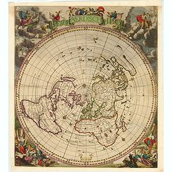
Nieuw Aerdsch Pleyn.
This rare world map in acartographical unusual" single polar projection.The copper plate was first published separately by Jacob Robyn in 1696. Already around 1700, ...
Date: Amsterdam, c. 1700
Selling price: ????
Please login to see price!
Sold in 2019
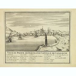
Veue ou Profil de Barcelone Capitale de Catalogne.
Panoramic view of Barcelona, with 23-point key.
Date: Paris, ca. 1700
Selling price: ????
Please login to see price!
Sold
(5 Maps !!!!!) Carte generale du monde. . ./ Voyage des enfant d\'israel / Het heylige land...Israels /Byzondere Kaart van de Landen daar de Apostelen. . . / Carte de la situation du paradis terrestre. . .
Beautiful world map from a Dutch Bible. The map is drawn on Mercator's projection with CALIFORNIA AS AN ISLAND and the Detroit d'Anian connected by dotted lines through t...
Date: Amsterdam, 1700
Selling price: ????
Please login to see price!
Sold in 2013
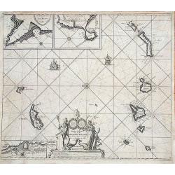
Nieuwe Pascaert van al de Carnarisse Eylande.
One of the most rare and sought after early maps of the Canary Islands. This large nautical map includes a latitude scale, a compass rose in the centre and a complex syst...
Date: Amsterdam, 1700
Selling price: ????
Please login to see price!
Sold in 2017
Exactissima totius danubii fluvii tabula et minores. . .
Showing the western part of the course of the River Danube. Including the towns of Heidelberg, Venice, Vienna, Budapest, etc. Published by Theodor Danckerts.The part has ...
Date: Amsterdam, 1700
Selling price: ????
Please login to see price!
Sold in 2013
![[Title page] De Munt der Graaven van Holland.](/uploads/cache/33229-250x250.jpg)
[Title page] De Munt der Graaven van Holland.
Title page from Kornelis van Alkemade's important book De Munt der Graaven van Holland. The book was printed in Delft by Andriez Voorstad, and was a banker's guide to cir...
Date: Delft, Andriez Voorstad, 1700
Selling price: ????
Please login to see price!
Sold in 2013
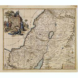
Carte de la TERRE SAINTE..
A fine map of the Holy Land depicting the tribes of Israel. A fine cartouche with Jesus preaching and healing. The scales with a cartographer and his pupil.
Date: Amsterdam, 1700
Selling price: ????
Please login to see price!
Sold in 2014
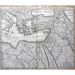
Carte Particuliere des Pais ou Les Apotres ont Preche l'Euan Gile; des Lieux les Plus Renommez de Leurs Voyages, et de la Route de St. Paul a Rome.
Detailed map of the Mediterranean and Middle East, illustrating the travels of St. Paul as he journeyed from Jerusalem to Rome. Very detailed, with numerous place names...
Date: Amsterdam, c1700
Selling price: ????
Please login to see price!
Sold in 2013
Tyrus.
This hand-colored, copper plate engraving shows a view of the port and city of Tyrus or Tyre, Lebanon. This scarce topographical print by de Bruyn is from: 'Voyage au Lev...
Date: Amsterdam, 1700
Selling price: ????
Please login to see price!
Sold in 2015
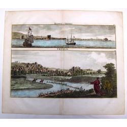
Marina di Tripoli & Tripoli.
This hand-colored, copper plate engraving shows two views of the port and city of Tripoli,Lybia. This scarce print is from: 'Voyage au Levant…” published by Henri de ...
Date: Amsterdam, 1700
Selling price: ????
Please login to see price!
Sold in 2013
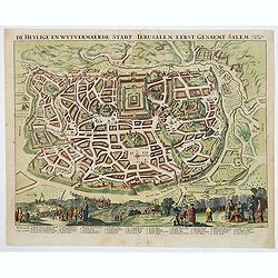
De Heylige en Wytvermaerde Stadt Jerusalem eerst genaemt Salem Genesis 14 Vers 18.
Very attractive imaginary bird's-eye of Jerusalem, showing the city laid out in blocksWith 36 principal sites numbered (1-36, A-D) and keyed to a table in lower margin. ...
Date: Amsterdam, c. 1700
Selling price: ????
Please login to see price!
Sold in 2014
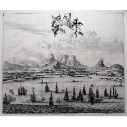
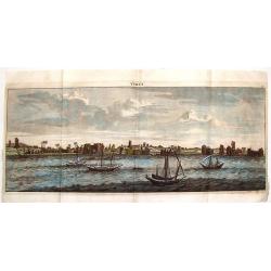
Le Cap de Bonne Esperance.
Fine view of Capetown from the seaside. With numerous sailing ships in the front. Tabletop mountaion in the back. Two putti holding the title banner. A six number key exp...
Date: Leiden, c1700
Selling price: ????
Please login to see price!
Sold in 2013
Ducatus Brunsuicensis in Eiusdem Tres Principatus Calenbergicum.
Fine map of the Duchy of Braunsweig. Featuring a large, splendid cartouche with nine coats of arms. The cities are shown as a detailed, miniature fortification. There are...
Date: Amsterdam, ca. 1700
Selling price: ????
Please login to see price!
Sold in 2017
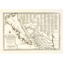
Cette Carte de Californie et du Nouveau Mexique.
A most important map, identifying by numerical code some 314 places in New Mexico, and showing in detail California as an island, although based on Sanson's monumental ma...
Date: Paris, 1700
Selling price: ????
Please login to see price!
Sold in 2013
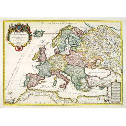
L\'Europe divisée suivant l\'estendue de ses principaux Estats...
Fine map of Europe, engraved by Cordier. With date "1695" in manuscript.
Date: Paris, c. 1700
Selling price: ????
Please login to see price!
Sold in 2013
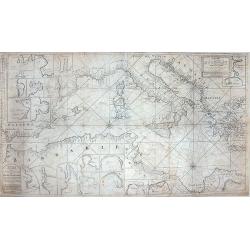
Paskaart van de Zee-kusten van Italie, Dalmatie, Sicilia, Grecia, Morea Malte en Candie. . .
A scarce, extensive nautical chart of the Mediterranean Sea, printed from two plates. We were not able to locate other specimens of this map. It depicts the coastlines of...
Date: Amsterdam, circa 1700
Selling price: ????
Please login to see price!
Sold in 2013
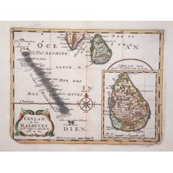
Ceylan, et les Maldives.
Exquisite map of Sri Lanka and the Maldives, with the southern tip of India shown at the top. Sri Lanka is shown in an inset named Ceylan Isle, qui est la Taprobane des A...
Date: Amsterdam 1700
Selling price: ????
Please login to see price!
Sold in 2014
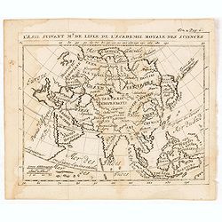
L'Asie suivant Mr. de Lisle de L'Academie royale des sciences.
RARE miniature map of Asia after de L'Isle. The map is of interest for the use of East Sea, the sea between Korea and Japan, here called "Mer Orientale".With Co...
Date: Paris, ca. 1700
Selling price: ????
Please login to see price!
Sold in 2014
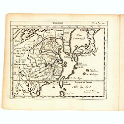
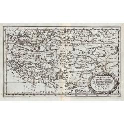
Chine.
RARE miniature map of China, Korea, Japan and Taiwan. The map is of interest for the use of East Sea, the sea between Korea and Japan, here called "Mer Orientale&quo...
Date: Paris, ca. 1700
Selling price: ????
Please login to see price!
Sold in 2014
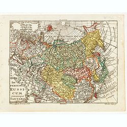
Imperium Russicum omnisque Tartaria.
Very finely engraved miniature map of Asian part of Russia with Korea and Japan. The map is of interest for the use of East Sea, the sea between Korea and Japan, here cal...
Date: Paris, ca. 1700
Selling price: ????
Please login to see price!
Sold in 2023
Pas caerte vande Custen van Loango, Angoy als mede en gedeelte van Angola, van C. de Lopa Goncalves, tot aen R. de Zaire.
Sea-chart of the coast of Loango.Latitude scale, compass rose and system of rhumb lines, soundings, anchorage's, etc.
Date: Amsterdam, ca. 1700
Selling price: ????
Please login to see price!
Sold in 2014
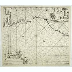
Pas caert van de Custen van Angola Van Rio de Zaire tot C. Negro. alles op zyn ware coers verheyt geleyt.
Sea-chart of the coast of Angola.Latitude scale, compass rose and system of rhumb lines, soundings, anchorage's, etc. Number "8" in lower right corner.
Date: Amsterdam, ca. 1700
Selling price: ????
Please login to see price!
Sold in 2014
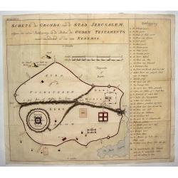
Schets des Gronds van de Stad Jerusalem.
Uncommon plan of ancient Jerusalem.
Date: ca. 1700
Selling price: ????
Please login to see price!
Sold in 2014
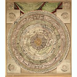
Veritable Representation des Premieres Matieres ou Elements avec leurs Directions. . .
A very rare double-page engraved circular representation of the world depicted in circular layers with Hell at its core, consisting of 9 concentric circles including the ...
Date: Haarlem, 1650 - 1700
Selling price: ????
Please login to see price!
Sold in 2014