Browse Listings
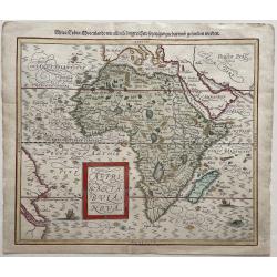
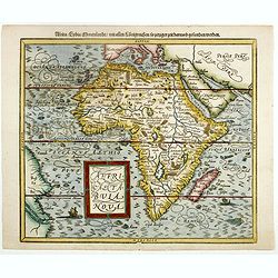
![[ Map of Africa ]](/uploads/cache/99986-250x250.jpg)
[ Map of Africa ]
Extremly rare map of Africa, engraved by William Rogers and published by John Wolfe. The map occurs in the 1598 English edition of Jan Huyghen van Linschoten's Itinerario...
Date: London, John Wolfe, 1598
Selling price: ????
Please login to see price!
Sold in 2011
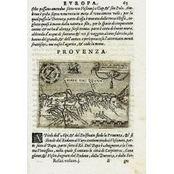
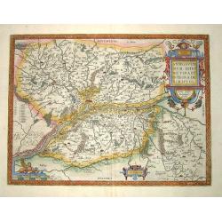
PROVENZA. GALLI NARBONESIS ORA MARITIMA RECETI
Rare copper-engraved miniature map by Giovanni Botero. Shows the Provence with North orientated to the bottom. Charming map with many place names. Decorated with a smal...
Date: Venice, 1598
Selling price: ????
Please login to see price!
Sold in 2011
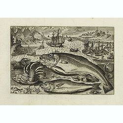
Faber marinus, Halee, Gabio, Acipenser Zeelandicus. (Piscium Vivæ Icones - Fish)
Depiction of Faber marinus, Halee, Gabio, Acipenser Zeelandicus. Set against a mountainous landscape in the manner of Pieter Brueghel the Elder. Plate number 8. The engra...
Date: Antwerp, after 1598
Selling price: ????
Please login to see price!
Sold in 2023
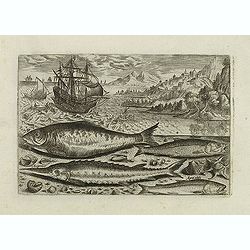
Alosa, Acipenser, Manula, Apua cobitis, (Piscium Vivæ Icones - Fish)
Depiction of Alosa, Acipenser, Manula, Apua cobitis, set against a mountainous landscape in the manner of Pieter Brueghel the Elder. Plate number 10. The engraving is cop...
Date: Antwerp, after 1598
Selling price: ????
Please login to see price!
Sold in 2023
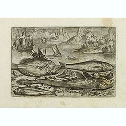
Asellus, Cancellus, Asellus mollis. (Piscium Vivæ Icones - Fish)
Depiction of Asellus, Cancellus, Asellus mollis. Fish set against a mountainous landscape in the manner of Pieter Brueghel the Elder. Plate number 13. The engraving is co...
Date: Antwerp, after 1598
Selling price: ????
Please login to see price!
Sold in 2017
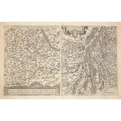
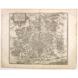
1) Palatinatvs Bavariae .. 2) Argentoratensis agri ..
From 'Theatrum Orbis Terrarum [Atlas of the Whole World]. The left hand map of Bavaria is after Erhart Reych's 4-sheet map of 1540. Including the towns of Regensburg, Nur...
Date: Antwerp, 1598
Selling price: ????
Please login to see price!
Sold in 2016
Geografia cioe Descrittione Universale della Terra ... Nuovamente ... Rincontrati, & Corretti ... Gio. Ant. Magini ... Opera ... Tradotta dal R.D. Leonardo Cernoti
The first edition of Leonardo Cernoti's Italian translation of Ptolemy's Geografia based on the 1596 Latin edition of Magini published by G. B. & G. Galignani in 1597...
Date: Venice, 1598
Selling price: ????
Please login to see price!
Sold in 2015
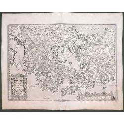
GRAECIA SOPHIANI.
An original copper engraving was published in 1598 in the famous historical Atlas 'Parergon' Latin text-edition by Abraham Ortelius. The map is ornate; with two cartouche...
Date: Antwerp, 1598
Selling price: ????
Please login to see price!
Sold in 2012
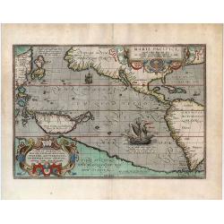
Maris Pacifici, (quod vulgo Mar del Zur) cum regionibus circumiacentibus, insulisque in codem passim sparsis, novissima descriptio.
"One of the most important maps that appeared in the Ortelius atlases, this was the first printed map to be devoted to the Pacific Ocean, the discovery of which is r...
Date: Antwerp, 1598
Selling price: ????
Please login to see price!
Sold in 2020
Andegavensium Ditionis Vera et Integra Descriptio.
A superbly engraved map of the area around Angers on the Loire exhibiting all the qualities for which Ortelius maps are renowened more that four hundred years after their...
Date: Antwerp, 1598
Selling price: ????
Please login to see price!
Sold in 2013
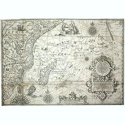
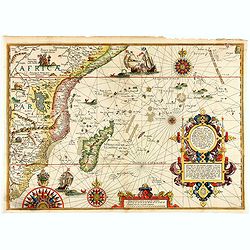
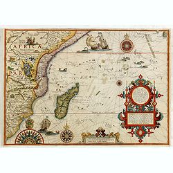
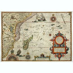
Affbeeldinghe der custen des landts...Terra do Natal.
A superbly decorative early chart engraved by Arnold van Langren showing the African coastline of the Indian Ocean from the Cape to Natal, Mozambique and Madagascar. From...
Date: Amsterdam, 1598
Selling price: ????
Please login to see price!
Sold in 2011
Affbeeldinghe der custen des landts Guinea, Manicongo. . .
A superbly decorative early chart engraved by Arnold van Langren. The ocean is filled with superbly engraved compass spurs, Dutch galleons and elaborate strapwork cartouc...
Date: Amsterdam, 1598
Selling price: ????
Please login to see price!
Sold in 2011
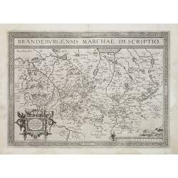
Brandeburgensis Marchiae Descriptio.
A very fine map centered on the towns of Brandenburg and Berlin. Nice title cartouche on the lower left corner.Prepared by Elias Camerius. Abraham Ortelius (1527-1598) wa...
Date: Antwerp, 1598
Selling price: ????
Please login to see price!
Sold in 2011
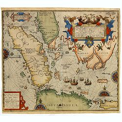
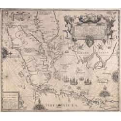
Nova tabula Insularum Javae, Sumatrae, Borneonis..
A most important foundation map, one of the first detailed European maps to focus on southern Malaysia and the region around present-day Singapore. The map was published ...
Date: Frankfurt, 1598
Selling price: ????
Please login to see price!
Sold in 2019
![Rovigno [View of Rovinj]](/uploads/cache/45192-250x250.jpg)
Rovigno [View of Rovinj]
Very rare view of Rovinj in Croatia situated on the north Adriatic Sea. Located on the western coast of the Istrian peninsula, it is a popular tourist resort and an activ...
Date: Venice, Giacomo Franco, 1598
Selling price: ????
Please login to see price!
Sold in 2023
![[The disposition of the Holy League fleet and that of the Ottoman Army during the Battle of Lepanto.]](/uploads/cache/45225-250x250.jpg)
[The disposition of the Holy League fleet and that of the Ottoman Army during the Battle of Lepanto.]
Very rare print of the disposition of the Holy League fleet and that of the Ottoman Army (semicircle) during the Battle of Lepanto (1571), published in the first edition ...
Date: Venice, Giacomo Franco, 1598
Selling price: ????
Please login to see price!
Sold in 2023
![Golfo di Lepanto. [Map of the Gulf of Nafpaktos]](/uploads/cache/45227-250x250.jpg)
Golfo di Lepanto. [Map of the Gulf of Nafpaktos]
Very rare map of Gulf of Nafpaktos, known as Lepanto. It is named for Naupaktos, an important Athenian naval station in the Peloponnesian war. As a strategically crucial ...
Date: Venice, Giacomo Franco, 1598
Selling price: ????
Please login to see price!
Sold in 2023
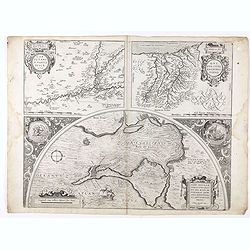
![Scharpanto [Map of Scharpantos]](/uploads/cache/45234-250x250.jpg)
Scharpanto [Map of Scharpantos]
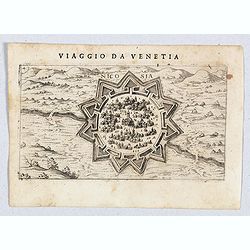
Very rare map of Karpathos Island published in the first edition of "Viaggio da Venetia, a Costantinopoli. Per Mare, e per Terra, & infieme quello di Terra Santa...
Date: Venice, Giacomo Franco, 1598
Selling price: ????
Please login to see price!
Sold
![Cipro [Map of Cyprus]](/uploads/cache/45237-250x250.jpg)
Cipro [Map of Cyprus]
Very rare map of Cyprus Island published in the first edition of "Viaggio da Venetia, a Costantinopoli. Per Mare, e per Terra, & infieme quello di Terra Santa. D...
Date: Venice, Giacomo Franco, 1598
Selling price: ????
Please login to see price!
Sold in 2020
![Famagosta [Plan of Famagusta]](/uploads/cache/45239-250x250.jpg)
Famagosta [Plan of Famagusta]
Very rare plan of Famagusta, situated east of Nicosia and possesses the deepest harbour of the island. During the medieval period (especially under the maritime republics...
Date: Venice, Giacomo Franco, 1598
Selling price: ????
Please login to see price!
Sold in 2020
Açores Insulae.
The importance of the Azores at that time was connected with the observation of Columbus that compass variation (i.e. the difference between the real and the magnetic nor...
Date: Antwerp, 1598
Selling price: ????
Please login to see price!
Sold in 2020
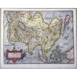
Asiae Nova Descriptio.
Ortelius' fine map of Asia well represents the continent at a time when Europeans were expanding their power in the far east.Showing all of Asia, India, Indonesia, the Fi...
Date: Antwerp, 1598
Selling price: ????
Please login to see price!
Sold in 2020
Hispalensis Conventus Delineatio, Auctore Hieronijmo Chiave...
The part of Andalusia centered on Seville, with Cadiz and Cordoba also shown. The second plate with overall stippling in the sea area (after 1595). The map is ornated wit...
Date: Antwerp, 1598
Selling price: ????
Please login to see price!
Sold in 2020
Carpetaniae Partis Desc.1584. - Guipus Coae Regionis Typus.
An ornate and highly decorative set of three maps on one sheet, Calretinin, (upper left), Guipuzcoa, (upper right) and Cadiz (lower center). The maps are highly decorativ...
Date: Antwerp, 1598
Selling price: ????
Please login to see price!
Sold in 2020
Delineatio orarum maritimarum, terræ vulgo indigetatæ terræ do Natal, item Sofalæ, Mozambicæ & Melindæ, insulæque Sancti Laurentii. . . / Affbeeldinghe der custen des landts genaempt terra do Natal, item van alle de custen van Coffala, Mozambique. .
A superbly decorative early chart engraved by Arnold van Langren showing the African coastline of the Indian Ocean from the Cape to Natal, Mozambique and Madagascar. Tool...
Date: Amsterdam, 1598
Selling price: ????
Please login to see price!
Sold in 2020
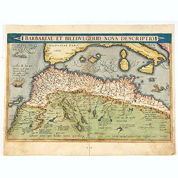
Barbariae et Biledulgerid, nova descriptio.
North-West Africa. Koeman speculated: In view of the important trading relationship between Antwerp and Africa, it is not impossible that the original was a manuscript ma...
Date: Antwerp, 1598
Selling price: ????
Please login to see price!
Sold in 2021
Nicosia.
A very rare view of Nicosia, also known as Lefkosia, the divided capital city of Cyprus and published in the first edition of "Viaggio da Venetia, a Costantinopoli. ...
Date: Venice, Giacomo Franco, 1598
Selling price: ????
Please login to see price!
Sold in 2020
![Polla/Viaggio Da Venetia [Pola in Istria] Rare 1st edition](/uploads/cache/84452-250x250.jpg)
Polla/Viaggio Da Venetia [Pola in Istria] Rare 1st edition
Very rare view of the City of Pola in Istria. From the rare first edition of "Viaggio da Venetia, a Costantinopoli. Per Mare, e per Terra, & infieme quello di Te...
Date: Venice, Giacomo Franco, 1598
Selling price: ????
Please login to see price!
Sold in 2021
![[View of Navarino]](/uploads/cache/45229-250x250.jpg)
[View of Navarino]
Very rare view of Navarino published in the first edition of "Viaggio da Venetia, a Costantinopoli. Per Mare, e per Terra, & infieme quello di Terra Santa. Da Gi...
Date: Venice, Giacomo Franco, 1598
Selling price: ????
Please login to see price!
Sold in 2022
![[View of Napoli Romania]](/uploads/cache/45231-250x250.jpg)
[View of Napoli Romania]
Very rare view of Nafplion published in the first edition of "Viaggio da Venetia, a Costantinopoli. Per Mare, e per Terra, & infieme quello di Terra Santa. Da Gi...
Date: Venice, Giacomo Franco, 1598
Selling price: ????
Please login to see price!
Sold in 2022

URBIBUM PRAECIPUARUM MUNDI THEATRUM QUINTUM, AUCTORE GEORGIO BRAUNIO AGRIPPINATE.
A fine example of the title page to the BRAUN & HOGENBERG 'CIVITATES..' VOL.5, together with the dedication sheet.The 'Civitates Orbis Terrarum' (Atlas of Cities of t...
Date: Cologne, 1598
Selling price: ????
Please login to see price!
Sold in 2021
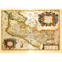
Hispania Novae Sivae magnae, Recens et Vera Descriptio 1579.
Abraham Ortelius’ map of Mexico appeared for the first time in the ‘Additamentum II’. State 2 with dots behind the names in the sea part. Strong decorative embellis...
Date: Antwerp, 1598
Selling price: ????
Please login to see price!
Sold in 2021
![Iaverinum vulgo Rab Anno 1594. [Gyor].](/uploads/cache/85304-250x250.jpg)
Iaverinum vulgo Rab Anno 1594. [Gyor].
A plan of Györ after a sketch by Nicolao Aginelli of 1566, redrawn by Joris Hoefnagel for the fifth volume of the 'Civitates Orbis Terrarum', the first systematic atlas ...
Date: Cologne, 1598
Selling price: ????
Please login to see price!
Sold in 2021
Afrika Tabula Nova
Woodcut map of the African continent: Münster second map of Africa, based upon Ortelius' map of 1570, from the German edition of Sebastian Münster's 'Cosmographey: das ...
Date: Basel, 1598
Selling price: ????
Please login to see price!
Sold in 2023
![Poitiers & Montargis. - Pictavia Vulgo Poictiers [on sheet with:] La pierre levee demie lieue de Poictiers [and] Prospectus Montis Henrici vulgo Montherri.](/uploads/cache/85896-250x250.jpg)
Poitiers & Montargis. - Pictavia Vulgo Poictiers [on sheet with:] La pierre levee demie lieue de Poictiers [and] Prospectus Montis Henrici vulgo Montherri.
Fine antique copper engraved sheet with one panoramic view, and two others by Braun and Hogenberg: Poitiers and Montargis from the uncommon fifth volume of Braun & Ho...
Date: Cologne, 1598
Selling price: ????
Please login to see price!
Sold in 2021
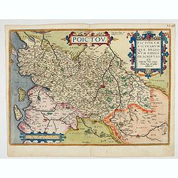
Poictou. Pictonum Vicinarum que Regionum Fidiss Descriptio.
Beautiful antique map of the former French province of Poitou, centered on the city of Poitiers.Reaching from the Atlantic to La Haye and Limoges and from Nantes to Cogna...
Date: Antwerp, 1598
Selling price: ????
Please login to see price!
Sold in 2022
![[Lot of 4 portraits, including Abraham Ortelius]](/uploads/cache/18958-(2)-250x250.jpg)
[Lot of 4 portraits, including Abraham Ortelius]
The portrait of Abraham Ortelius appeared in the editions of his ‘Theatrum’ published after his death in 1598. See M.C.C. no.105.The engraver is Ph. Galle.Lot of 4 po...
Date: Antwerp, after 1598
Selling price: ????
Please login to see price!
Sold in 2022
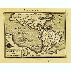
America sive novvs.
Scarce miniature map of the Americas. From the second series of miniature atlas of Ortelius' Epitome. A new series of pocket-size atlases was begun by Philip Galle in 158...
Date: Antwerp, 1598
Selling price: ????
Please login to see price!
Sold in 2012
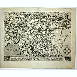
Schlavoniae, Croatiae, Carniale.. Bosniae. . .
First state. Fine and early map of former Yugoslavia after a map of Hirschvogel (1552-1565) and used by A.Ortelius in his atlas 'Theatrum Orbis Terrarum [Atlas of the Who...
Date: Antwerp, 1598
Selling price: ????
Please login to see price!
Sold in 2014
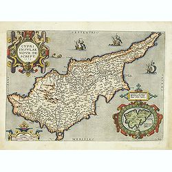
Cypri Insulae Nova descript. 1573.
This is a beautiful copy of a classic map of Cyprus. It is the earliest obtainable version of the best map of Cyprus made to date. Ortelius based his map upon that publis...
Date: Antwerp, 1598
Selling price: ????
Please login to see price!
Sold in 2012
![Daniae Regni Typus . . . / Cimbricae Chersonesi. .. [2 maps].](/uploads/cache/32297-250x250.jpg)
Daniae Regni Typus . . . / Cimbricae Chersonesi. .. [2 maps].
Two maps on one sheet. The left hand is centered on Denmark, with a credit to the cartographer, Cornelis Anthoniszoon (1499-1557) Cornelius Antoniades Descripsit .The rig...
Date: Antwerp, 1598
Selling price: ????
Please login to see price!
Sold in 2012
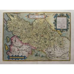
Poictou / Pictonum Vicinarum Que Regionum Fidiss Descriptio...
Beautiful old colored map of the Poitou in Western France by Abraham Ortelius. Showing the Atlantic coast with La Rochelle up to Limoges in the East. Includes the Loire r...
Date: Antwerp, 1598
Selling price: ????
Please login to see price!
Sold in 2015
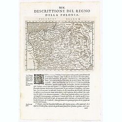
Poloniae Regnum.
A detailed map of Poland, Lithuania and the Ukraine stretching from the Baltic Sea in the north to the Black Sea in the south.Italian text on recto and verso.The map come...
Date: Venice, Galignani, 1597-1598
Selling price: ????
Please login to see price!
Sold in 2018
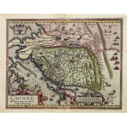
Chinae, olim Sinarum Regionis, nova descriptio. Auctore Ludovico Georgio.
From the rare Dutch text edition of the Theatrum of which according to van den Broecke only 100 copies are printed.The first map of China ever to appear in a Western atla...
Date: Antwerp, 1598
Selling price: ????
Please login to see price!
Sold in 2016

Maris Pacifici.
From the rare Dutch text edition of the Theatrum of which according to van den Broecke only 100 copies are printed.This was the first printed map to be devoted solely to ...
Date: Antwerp, 1598
Selling price: ????
Please login to see price!
Sold in 2025
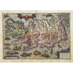
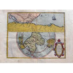
Islandia.
From the rare Dutch text edition of the Theatrum of which according to van den Broecke only 100 copies are printed.Perhaps the most famous map of Iceland. On the south si...
Date: Antwerp, 1598
Selling price: ????
Please login to see price!
Sold in 2016

Dondem Leutschen Lande.
A woodcut leaf from Munster's Cosmographia. It features two workers with implements and other workers building a house. There is German text on the front and back and a s...
Date: Nuremberg, 1598
Selling price: ????
Please login to see price!
Sold in 2013
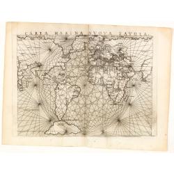
Carta Marina nuova tavola.
Ruscelli's mariner's map is a slightly enlarged version of the map which appeared in Gastaldi's edition of Ptolemy thirteen years earlier. The only change seems to be the...
Date: Venice, 1598
Selling price: ????
Please login to see price!
Sold in 2014
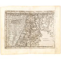
Soria et Terra Santa nuova tavola.
Early map of this classical map of the Holy Land, including Cyprus, prepared by Giovanni Botero. The copper plate was however later used by Giuseppe Rosaccio's expended e...
Date: Venice, 1598
Selling price: ????
Please login to see price!
Sold in 2014
Saintes.
Bid's-eye view of Saintes with the river la Charente in the front. French text on verso.
Date: Cologne, 1598
Selling price: ????
Please login to see price!
Sold in 2014
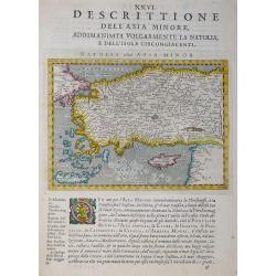
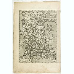
Desrittione Dell'Asia Minore addimandata volgarmente La Natolia e dell'Isole circongiacenti.
Map shows Turkey, Cyprus and Greek Islands along Turkish coast south to the Island of Crete (Candia) and the Syrian coast. Verso: related text.ublished in “Geografia ci...
Date: Venice, 1598
Selling price: ????
Please login to see price!
Sold in 2017
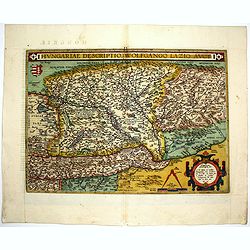
Hungariae Descriptio ..
A very fine map of Hungary, centered on Budapest. The map was prepared by Wolfgang Lazius in 1556. Very decorative cartouche on the lower right corner.Abraham Ortelius (1...
Date: Antwerp, 1598
Selling price: ????
Please login to see price!
Sold in 2014
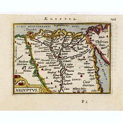
Aegyptus.
Very fine early miniature map of Egypt, showing the Nile delta . Title cartouche on the lower left corner. Scarce miniature map from the second series of miniature atlas ...
Date: Antwerp, 1598
Selling price: ????
Please login to see price!
Sold in 2015
Affbeeldinghe der custen des landts. . .Terra do Natal.
A superbly decorative early chart engraved by Arnold van Langren showing the African coastline of the Indian Ocean from the Cape to Natal, Mozambique and Madagascar. From...
Date: Amsterdam, 1598
Selling price: ????
Please login to see price!
Sold in 2015
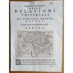
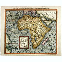
Africa Tabula Nova.
Africa continent map by Ortelius, used in Giovanni Botero (1533–1617)'s work "RELATIONI UNIVERSALI DI GIOVANNI BOTERO BENESE" issued in Venice by Giorgio Ang...
Date: Venice, c.1598
Selling price: ????
Please login to see price!
Sold in 2016
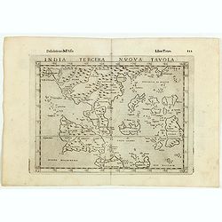
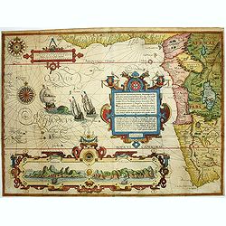
India Tercera Nuova Tavola.
Fine 1598 edition of this early map of South East Asia. Just to the west and south of Malacca one will notice ‘Camatra’ (Sumatra) and Java. China with Canton in the u...
Date: Venice, 1598
Selling price: ????
Please login to see price!
Sold in 2016
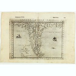
Calecut Nova Tavola.
Fine early map of Indian peninsula, being one of the earliest modern maps of the region.Girolamo Ruscelli first published the map in his "La Geographi di Claudio Tol...
Date: Venice, 1598
Selling price: ????
Please login to see price!
Sold in 2016
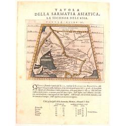
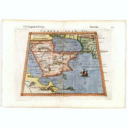
Tavola Della Sarmatia Asiatica, La Seconda Del L'Asia.
This is the second Prolemy map of Asia. It features the Crimea region of Russia showing the Caucasus region north of the Black Sea and east of the Sea of Asov with a smal...
Date: Venice, 1598
Selling price: ????
Please login to see price!
Sold in 2018
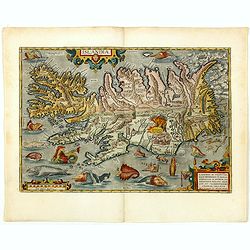
Islandia.
Perhaps the most famous map of Iceland. On the south side of the island a collection of all possible sea monsters is depicted. Polar bears on ice flows and volcanoes in t...
Date: Antwerp, 1598
Selling price: ????
Please login to see price!
Sold in 2015
Florentini Dominii Fidelissima et nova descriptio.
Very fine map bu Ortlius including the towns of Pisa, Florence, Siena, etc. The map is based on Stefano Buonsignori's map.Copper engraving with French text on verso. Abra...
Date: Antwerp, 1598
Selling price: ????
Please login to see price!
Sold in 2015
Natoliae quae olim Asia minor.
East to the top. Detailed map Turkey, including Cyprus and Crete.
Date: Antwerp, 1598
Selling price: ????
Please login to see price!
Sold in 2015
Exacta & accurata.. regionibus China, Cauchinchina, Camboja..
...the Far East and the Malay Archipelago are represented in such detail as was known only to the Portuguese at that time and had never before shown on a printed map. (S...
Date: Amsterdam, 1598
Selling price: ????
Please login to see price!
Sold in 2017
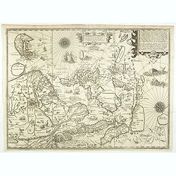
Nova tabula Insularum Javae, Sumatrae, Borneonis. . .
A most important foundation map, one of the first detailed European maps to focus on southern Malaysia and the region around present-day Singapore. The map was published ...
Date: Frankfurt, 1598
Selling price: ????
Please login to see price!
Sold in 2015
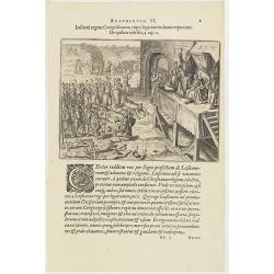
Argumentum II. Lufitani regem Congi falutant, eique legationem fuam exponunt. De quibus Vide lib. 2 cap 2.
The Portuguese appear before the king of the Congo. When the king of the Congo heard about his neighbor, the prince of Sogno, being converted to Christianity, he called t...
Date: Frankfurt, 1598
Selling price: ????
Please login to see price!
Sold in 2019
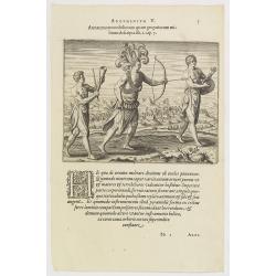
Argumentum V. Armatura tam nobiliorum quam gregariorum militum descripta lib. 1. cap. 7. (How the Congolese dress for war and play)
The distinguished inhabitants of the Congo decorate their head-dresses with ostrich, peacock or other feathers and, wound cross-wise across their bare chests they have ch...
Date: Frankfurt, 1598
Selling price: ????
Please login to see price!
Sold in 2016

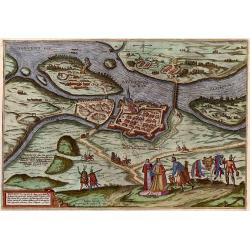
Palatium Regium in Angliæ Regno Appelatum Nonciutz. . .
This engraving is a view of Nonsuch Palace, with carriages and deer hunting, a panel of female costume figures below. Latin text verso, dated in the plate 1582. The scene...
Date: Cologne, 1598
Selling price: ????
Please login to see price!
Sold in 2016
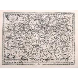
Austriae Descrip. per Wolfgangum Lazium.
An early map of eastern Austria, Salzburg to Bratislava. In the south until Carinthia and the Drau river. An excellent and detailed map with many cities and towns, rivers...
Date: Amsterdam, 1598
Selling price: ????
Please login to see price!
Sold in 2017
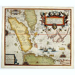
Nova tabula Insularum Javae, Sumatrae, Borneonis..
A most important foundation map, one of the first detailed European maps to focus on southern Malaysia and the region around present-day Singapore. The map was published ...
Date: Frankfurt, 1598
Selling price: ????
Please login to see price!
Sold in 2016
Africae tabula nova / Africa, Lybia, Morenlandt, mit allen Königreichen so jetziger zeit darumb gefunden werden. . .
Attractive woodcut map showing the African continent. From the 1598-German edition of Cosmographia by Sebastian Münster. German text on verso. This woodblock map is eleg...
Date: Basle, 1598
Selling price: ????
Please login to see price!
Sold in 2016
Wirtenberg Ducatus.
Ortelius copied the map after Georg Gadner's map of 1572.Very decorative and a masterpiece in the sense of engraving and composition.
Date: Antwerp, 1598
Selling price: ????
Please login to see price!
Sold in 2016
Tabula Asiae VI.
Scarce third edition of this classical map of the Arabian Peninsular, with the addition of the galleon and sea monster. This map is an enlarged version of Giacomo Gastald...
Date: Venice, 1598
Selling price: ????
Please login to see price!
Sold in 2016
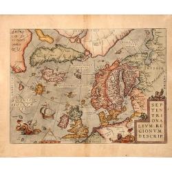
SEPTENTRIONALIUM REGIONUM DESCRIP, 1598
A copperplate full colored decorative map of North Europe.This influential map of the Arctic, including Scandinavia, Iceland, Greenland and part of the North American con...
Date: Antwerp, 1598
Selling price: ????
Please login to see price!
Sold in 2019
Chica sive Patagonica et Australis terra. 1598.
Two maps on a single sheet: The upper map shows the Strait of Magellan separating Patagonia from Terra Australis. Shows the ill-fated Spanish colony of Philippopolis.The ...
Date: Cologne, ca 1598
Selling price: ????
Please login to see price!
Sold in 2017
Africae tabula nova / Africa, Lybia, Morenlandt, mit allen Königreichen so jetziger zeit darumb gefunden werden. . .
Attractive woodcut map showing the African continent. From the 1598-German edition of Cosmographia by Sebastian Münster. German text on verso. This woodblock map is eleg...
Date: Basle, 1598
Selling price: ????
Please login to see price!
Sold in 2018
Delineatio orarum maritimarum, terræ vulgo indigetatæ terræ do Natal, item Sofalæ, Mozambicæ & Melindæ, insulæque Sancti Laurentii. . . / Affbeeldinghe der custen des landts genaempt terra do Natal, item van alle de custen...
A superbly decorative early chart engraved by Arnold van Langren showing the African coastline of the Indian Ocean from the Cape to Natal, Mozambique and Madagascar. Tool...
Date: Amsterdam, 1598
Selling price: ????
Please login to see price!
Sold in 2022
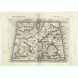
Europae Tabula VIII.
The third state of Ruscelli's map of Eastern Europe and Scandinavia, based upon Claudius Ptolemy. Showing "Daniae et Norvegiae" as an island, with a separate is...
Date: Venice, 1598
Selling price: ????
Please login to see price!
Sold in 2018
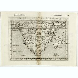
Africa Nuova Tavola.
Fine 1598 edition of this early map of southern Africa. Girolamo Ruscelli first published the map in his "La Geographi di Claudio Tolomeo" (Venice, 1561), with ...
Date: Venice, 1598
Selling price: ????
Please login to see price!
Sold in 2021
Iaverinum vulgo Rab.
View of Gyor, engraved by G. Hoefnagel, from Braun & Hogenberg's "Civitatus Orbis Theatrum", the most famous atlas of city views published in the 16th Centu...
Date: Cologne, 1598
Selling price: ????
Please login to see price!
Sold in 2017
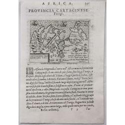
Provincia Cartaginese. Tunigi.
An attractive small map of the environs of Tunis in Northern Africa. It is from the "Relationi Universale" by Botero, published in Venice in 1598. Woodcut in pa...
Date: Venice, 1598
Selling price: ????
Please login to see price!
Sold in 2017

Turcici Imperii Descriptio.
A map depicting the Turkish Empire, with the Arabian Peninsular at its center. Taken from the 1598 Italian printing of Giovanni Antonio Magini's edition of Claudius Ptole...
Date: Venice, 1598
Selling price: ????
Please login to see price!
Sold in 2018