Subscribe to be notified if similar examples become available.
Geografia cioe Descrittione Universale della Terra ... Nuovamente ... Rincontrati, & Corretti ... Gio. Ant. Magini ... Opera ... Tradotta dal R.D. Leonardo Cernoti |
||||||||||||||||||||
|
||||||||||||||||||||
|
|
||||||||||||||||||||
|
Selling price: $ Please login to see price!
Sold in 2015 Missed this item! Add your name to our mailing list and be the first to get notified about our newly added listings. . |
My Collection + - Save and collect this or any of your favorite items in one place.
If you want to save the items permanently, please sign in or create account first. |
|||||||||||||||||||
Description
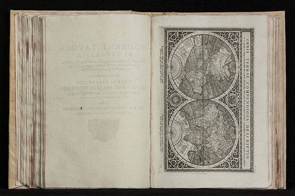
The first edition of Leonardo Cernoti's Italian translation of Ptolemy's Geografia based on the 1596 Latin edition of Magini published by G. B. & G. Galignani in 1597-98.
The beautiful engraved maps are attributed to Girolamo Porro and have been also used in Magini's translation of 1596.
Illustrated with two engraved title vignettes, one full page and 63 half page engraved maps and several woodcuts in the text. Whereof 27 Ptolemy maps and 37 'modern' map, including 4 world maps (one Ptolemy /Shirley 193, three modern /Shirley 194, 195, 196), 1 map of America (Burden 93), 32 European maps, 6 maps of Africa and 21 maps of Asia.
The beautiful maps have been engraved by G. Porro. Mentionable the three 'modern' world maps, first the full sheet map (Shirley 194) showing a classical late 16th century configuration of the world with a large "Terrae Australis" in the south, the Northwest passage with unusual shape of the North Pole and the bulky west coast of South America. Also the mythical islands in the Atlantic are present.
Shirley mentioned, 'it's the artist's credit that so much detail have been represented with such fineness and clarity...
This small Mercator-Porro map is a worthwhile collector's item, particularly as the larger Mercator world map is becoming increasingly scarce.'
The second modern world map is a reduced version of the 1570 Ortelius map, surrounded by six wind heads (Shirley 195).
Magini's mariner's map (Shirley 196) follows Gerard Mercator's large world map of 1569, with fanciful addition of chains of mountains across the souther continent.
Beside the world maps, four continental map of Asia, Africa, America and Europe are included, whereas the Africa map showing parts of Brazil and the Asia map also including elements of America.
There are three other maps with parts of America: 'Scandia, sive Regiones Septentrionales' showing the north Atlantic with parts of Labrador (Burden 98), 'Tartariae Imperium' with Japan, parts of Canada and California (Burden 95), and finally 'India Orientalis', the attractive map of south-east Asia with the west coast of North America.
Reference: Shirley T.PTOL 12b.
FAQ - Guarantee - Shipping
Buying in the BuyNow Gallery
This item is available for immediate purchase when a "Add to Cart" or "Inquire Now" button is shown.
Items are sold in the EU margin scheme
Payments are accepted in Euros or US Dollars.
Authenticity Guarantee
 We provide professional descriptions, condition report (based on 45 years experience in the map business)
Paulus Swaen warrants the authenticity of our items and a certificate of authenticity is provided for each acquired lot.
Condition and Coloring
We indicate the condition of each item and use our unnique HiBCoR grading system in which four key items determine a map's value: Historical Importance, Beauty, Condition/Coloring and Rarity.
Color Key
We offer many maps in their original black and white condition. We do not systematically color-up maps to make them more sellable to the general public or buyer.
Copper engraved or wood block maps are always hand colored. Maps were initially colored for aesthetic reasons and to improve readability. Nowadays, it is becoming a challenge to find maps in their original colors and are therefor more valuable.
We use the following color keys in our catalog:
Original colors; mean that the colors have been applied around the time the map was issued.
Original o/l colors; means the map has only the borders colored at the time of publication.
Colored; If the colors are applied recently or at the end of the 20th century.
Read more about coloring of maps [+]
Shipping fee
A flat shipping fee of $ 30 is added to each shipment by DHL within Europe and North America. This covers : International Priority shipping, Packing and Insurance (up to the invoice amount).
Shipments to Asia are $ 40 and rest of the world $50
We charge only one shipping fee when you have been successful on multiple items or when you want to combine gallery and auction purchases.
Read more about invoicing and shipping
FAQ
Please have a look for more information about buying in the BuyNow gallery
Many answers are likely to find in the general help section.
My Collection+
![]()
With My Collection+ you can collect all your favorite items in one place. It is free, and anyone can create his or her virtual collection.
Unless you are logged in, the item is only saved for this session. You have to be registed and logged-in if you want to save this item permanently to My Collection+.
Read More[+]
Register here, it is free and you do not need a credit card.
Add this item to
My Collection+
or click the following link to see My Collection+.
| Digital Image Download | |
|
Paulus Swaen maintains an archive of most of our high-resolution rare maps, prints, posters and medieval manuscript scans. We make them freely available for download and study. Read more about free image download |
Click the image for a free small image download. |
In accordance with the EU Consumer Rights Directive and habitually reside in the European Union you have the right to cancel the contract for the purchase of a lot, without giving any reason.
The cancellation period will expire 14 calendar days from the day after the date on which you or a third party (other than the carrier and indicated by you) acquires, physical possession of the lot. To exercise the right to cancel you must inform Paulus Swaen Inc, of your decision to cancel this contract by a clear statement (e.g. a letter sent by post, or e-mail (amsterdam@swaen.com).
To meet the cancellation deadline, it is sufficient for you to send your communication concerning your exercise of the right to cancel before the cancellation period has expired.
