Browse Listings
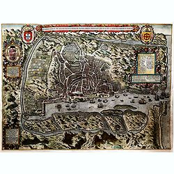
A ilhae cidade de Goa metropolitanada Indiae. . .
One of the earliest printed detailed plans of a European trading post in the Indies, this finely engraved and designed bird's-eye plan was made by Baptista a Doetecum and...
Date: Amsterdam, 1598
Selling price: ????
Please login to see price!
Sold in 2019
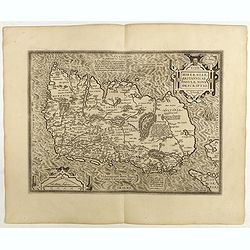
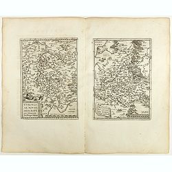
Hiberniae Britannicae insulae nova descriptio.
Copied from Mercator's influential wall map of the British Isles of 1564, this is certainly the best map of Ireland of the 16th century.Dare to go in Black. All early map...
Date: Antwerp, 1598
Selling price: ????
Please login to see price!
Sold in 2018
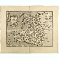
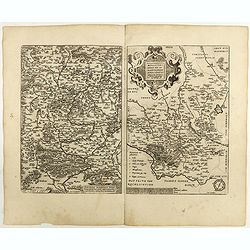
Cambriae Typus.
Ancient map of Wales, prepared by Humphrey Lhuyd. With fine cartouche, part of a compass-rose and a sea monster.Dare to go in Black. All early maps are printed in black a...
Date: Antwerp, 1598
Selling price: ????
Please login to see price!
Sold in 2018
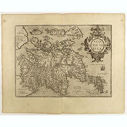
Scotiae tabula.
Fine general map of Scotland with north to right of page. Derived from Mercator's 1564 map of the British Isles in 8 sheets.Dare to go in Black. All early maps are printe...
Date: Anwerp, 1598
Selling price: ????
Please login to see price!
Sold in 2018
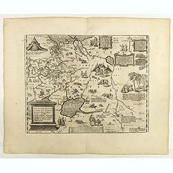
Valentiae Regni ...
An attractive map of the province of Valence. Title cartouche centered on the lower part.Dare to go in Black. All early maps were printed in black and white, and many wer...
Date: Antwerp, 1598
Selling price: ????
Please login to see price!
Sold in 2019
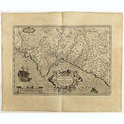
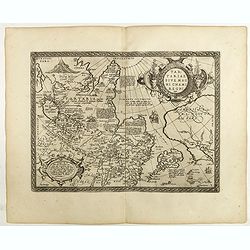
Portugalliae que olim Lusitania.
The best-known map of Portugal, after Alvares Secco (1560), orientated west to the top of the sheet. Many mapmakers and publishers copied Secco's map for upwards of a cen...
Date: Antwerp, 1598
Selling price: ????
Please login to see price!
Sold in 2018
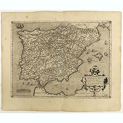
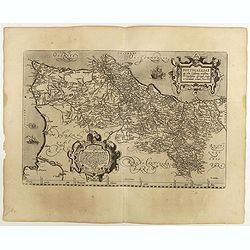
Regni Hispaniae Post Omnium Editio..
Very decorative map of Spain and Portugal including Majorca and Minorca.Dare to go in Black. All early maps were printed in black and white, and many were kept that way f...
Date: Antwerp, 1598
Selling price: ????
Please login to see price!
Sold in 2018
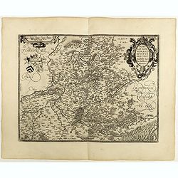
Nobilis Hanoniae Comitatus descrip.
Including part of Belgium and the northern part of France.Dare to go in Black. All early maps were printed in black and white, and many were kept that way for a long time...
Date: Antwerp, 1598
Selling price: ????
Please login to see price!
Sold in 2018
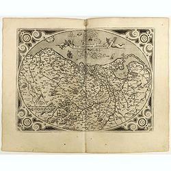
Descriptio Germaniae Inferioris.
The oval map is surrounded by a strapwork frame and the title, adorned with ribbons, is held aloft by two winged cherubs. Dare to go in Black. All early maps were prin...
Date: Antwerp, 1598
Selling price: ????
Please login to see price!
Sold in 2021
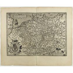
Germania.
General map of Germany, including Switzerland, Austria, The Netherlands and Belgium. Dare to go in Black. All early maps were printed in black and white, and many were...
Date: Antwerp, 1598
Selling price: ????
Please login to see price!
Sold in 2021
Burgundiae Comitatus Recentiss. Descriptio.
From 'Theatrum Orbis Terrarum [Atlas of the Whole World]'. Dare to go in Black. All early maps were printed in black and white, and many were kept that way for a long ...
Date: Antwerp, 1598
Selling price: ????
Please login to see price!
Sold in 2022
Westphaliae . . .
A very fine map of Westphalia prepared by Christian sGroten. A very decorative cartouche on the upper right corner.Abraham Ortelius (1527-1598) was a cartographer and pub...
Date: Antwerp, 1598
Selling price: ????
Please login to see price!
Sold in 2022
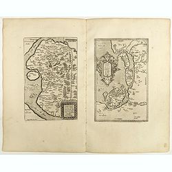
Thietmarsiae Holsaticae . . . (together with) Rugiae . . .
Two maps on one sheet: Left a fine map of Holstein: The island of Rugia and part of Pomerania on the right hand sheet. Abraham Ortelius (1527-1598) was a cartographer and...
Date: Antwerp, 1598
Selling price: ????
Please login to see price!
Sold in 2022
![Daniae Regni .. / Oldenburg Com. [2 maps].](/uploads/cache/40978-250x250.jpg)
Daniae Regni .. / Oldenburg Com. [2 maps].
Two maps on one sheet. The left hand is centered on Denmark, with a credit to the cartographer, Cornelis Anthoniszoon (1499-1557) Cornelius Antoniades Descripsit .The rig...
Date: Antwerp, 1598
Selling price: ????
Please login to see price!
Sold in 2018
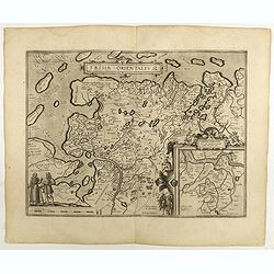
Frisia Orientalis.
Includes the provinces of Friesland. The map was prepared by Jan Bloemmaerts. Dare to go in Black. All early maps were printed in black and white, and many were kept t...
Date: Antwerp, 1598
Selling price: ????
Please login to see price!
Sold in 2023
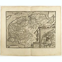
Frisia Occidentalis.
Includes the provinces of Friesland and Groningen. The map was prepared by Sibrandus Leonis (Leo Sybrands) from Leeuwarden in 1579. In a large inset a map of the Netherla...
Date: Antwerp, 1598
Selling price: ????
Please login to see price!
Sold in 2022
Flandriae Comitatus Descriptio.
Very fine map of Flanders, after Gerard Mercator's map of 1540. Dare to go in Black. All early maps were printed in black and white, and many were kept that way for a ...
Date: Anvers, 1598
Selling price: ????
Please login to see price!
Sold in 2018
Russiae, Moscoviae et Tartariae Descriptio.
The map was engraved by Franz Hogenberg from an original by Anthony Jenkinson of the English Muscovy Company, drawn in 1562. Jenkinson traveled to Bukhara in 1557-59 and ...
Date: Antwerp, 1598
Selling price: ????
Please login to see price!
Sold in 2025
Tartariae sive magni Chami regni typus.
Much of the information shown on this map relates to the travels of Marco Polo between 1275 and 1291 with later information gained from the Portuguese Jesuit missionaries...
Date: Antwerp, 1598
Selling price: ????
Please login to see price!
Sold in 2018
Fessae et Marocchi regna Africae celeberr.
Uncommon map, covering north-western Africa, with the Canaries and Madeira. With an inset of the Congo, after Filippo Pigafetta's famous map of the kingdom. Dare to go...
Date: Antwerp, 1598
Selling price: ????
Please login to see price!
Sold in 2020
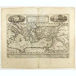
Peregrinationis Divi Pauli Typus..
A splendid map depicting the travels of Paulus. With two fine scenes in top. Showing the countries along the Mediterranean, including Cyprus and Italy. A first edition wi...
Date: Antwerp, 1598
Selling price: ????
Please login to see price!
Sold in 2022
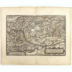
Austriae Descrip. Par Wolfganum Lazium.
Early map of the Duchy of Austria, engraved after the cartographic source by Wolfgang Lazius.Dare to go in Black. All early maps were printed in black and white, and many...
Date: Antwerp, 1598
Selling price: ????
Please login to see price!
Sold in 2021
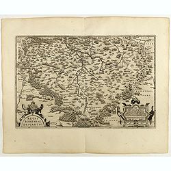
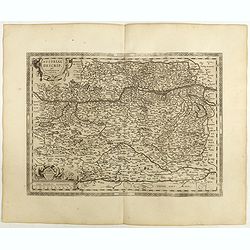
Regni Bohemiae descriptio.
Fine and early map of Czechoslovakia after Johann Criginger. and used by A.Ortelius in his atlas 'Theatrum Orbis Terrarum [Atlas of the Whole World].Only included in the ...
Date: Antwerp, 1598
Selling price: ????
Please login to see price!
Sold in 2019
Ducatus Mediolanensis.
A very nice map of Italy, centered on Milan, prepared by Johannes Septala. Very decorative title cartouche on the left side. A sea monster and a ship are depicted on the ...
Date: Antwerp, 1598
Selling price: ????
Please login to see price!
Sold in 2022
Veronae Urbis Territorium.
Very fine map of part of Italy centered on Verona, Vizenza and Lake Garda. Prepared by Bernardino Brugnoli, which first was published in 1574 by Forlani. Ortelius' map is...
Date: Antwerp, 1598
Selling price: ????
Please login to see price!
Sold in 2018
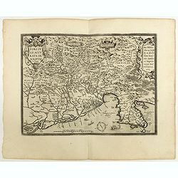
Fori Ivlii accvrata descriptio
Map from 'Theatrum Orbis Terrarum [Atlas of the Whole World]': published in Antwerp.Dare to go in Black. All early maps are printed in black and white and many were kept ...
Date: Antwerp, 1598
Selling price: ????
Please login to see price!
Sold in 2018
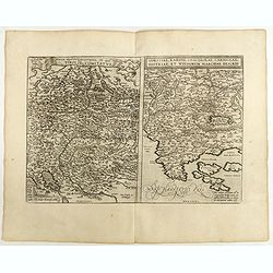
Rhetiae alpestris descriptio, . . . Goritiae, Karstii, . . .
Two maps from 'Theatrum Orbis Terrarum [Atlas of the Whole World]':published in Antwerp.Dare to go in Black. All early maps are printed in black and white and many were k...
Date: Antwerp, 1598
Selling price: ????
Please login to see price!
Sold in 2020
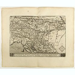
Schlavoniae, Croatiae, Carniale.. Bosniae. . .
Fine and early map of former Yugoslavia after a map of Hirschvogel (1552-1565) and used by A.Ortelius in his atlas 'Theatrum Orbis Terrarum [Atlas of the Whole World]. Wi...
Date: Antwerp, 1598
Selling price: ????
Please login to see price!
Sold in 2022
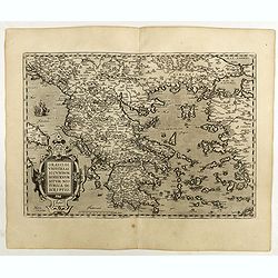
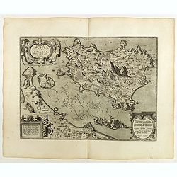
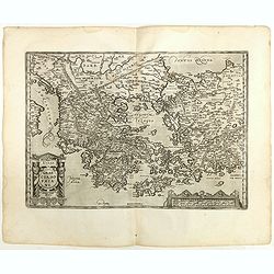
Graeciae Universae Secundum Hodiernum Situm Neoterica descriptio.
Ortelius' fine map of Greece, based on Jacobo Gastaldi's map of 1560. The early imprint with the uncorrected scale bar numeral.Dare to go in Black. All early maps are pri...
Date: Antwerp, 1598
Selling price: ????
Please login to see price!
Sold in 2018
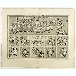
Archipelagi Insularum Aliquot Descrip.
Very decorative map showing map of Crete and 10 insets of Greek islands: Candia, Metellino, Santorini, Milo, Rodus, Scio, etc.Dare to go in Black. All early maps are prin...
Date: Antwerp, 1598
Selling price: ????
Please login to see price!
Sold in 2021
Ischia, quae olim Aenaria.
Prepared by Giulio Iasolino (1537-1622), who wrote a book about Ischia in 1568 and its beneficial baths which included a map of the island, which Ortelius faithfully foll...
Date: Antwerp, 1598
Selling price: ????
Please login to see price!
Sold in 2018
Perusini Agri.
A very nice map of northern province of Italy, centered on Perugia. Very nice title cartouche on the lower right corner, with a credit to the cartographer who prepared th...
Date: Antwerp, 1598
Selling price: ????
Please login to see price!
Sold in 2019
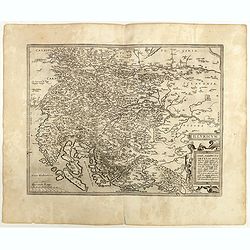
Transilvania.
Detailed map of Hungary prepared by Sambucas in 1566, who itself based his map on Honter's map of 1532.Dare to go in Black. All early maps are printed in black and white ...
Date: Antwerp, 1598
Selling price: ????
Please login to see price!
Sold
Ungariae Loca Praecipva..
Map of Hungary.Dare to go in Black. All early maps are printed in black and white and many were kept that way for a long time. A black and white map in an early and stron...
Date: Antwerp, 1598
Selling price: ????
Please login to see price!
Sold in 2022
Illyricum.
Early map of Istria and Slovenia. Prepared by Johann Sambucus 1572. Abraham Ortelius (1527-1598) was a cartographer and publisher, who is born and died in Antwerp. Publis...
Date: Antwerp, 1598
Selling price: ????
Please login to see price!
Sold in 2018
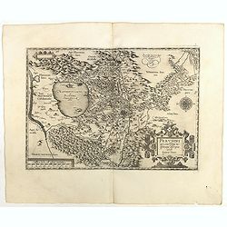
Graeciae Sophiani.
This is a beautiful depiction of ancient Greece. The map has a beautiful title cartouche in the shape of a Grecian temple in the bottom left-hand corner and a large scale...
Date: Antwerp, 1598
Selling price: ????
Please login to see price!
Sold in 2018
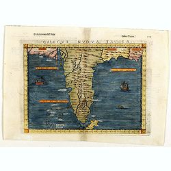
Calecut Nuova Tavola.
Fine 1598 edition of this early map of India. Girolamo Ruscelli first published the map in his "La Geographi di Claudio Tolomeo" (Venice, 1561), with the presen...
Date: Venice, 1598
Selling price: ????
Please login to see price!
Sold in 2018
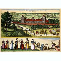
Palatium Regium in Angliæ Regno Appelatum Nonciutz. . .
This fine engraving is a view of Nonsuch Palace, with carriages and deer hunting, a panel of female costume figures below. Latin text verso, dated in the plate 1582. The ...
Date: Cologne, 1598
Selling price: ????
Please login to see price!
Sold in 2019
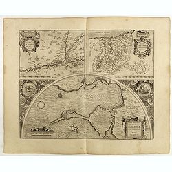
Carpetaniae Partis Desc.1584. - Guipus Coae Regionis Typus.
An ornate and highly decorative set of three maps on one sheet, Carpetanin, (upper left), Guipuzcoa, (upper right) and Cadiz (lower center). The maps are highly decorativ...
Date: Antwerp, 1598
Selling price: ????
Please login to see price!
Sold in 2018
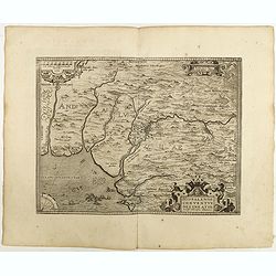
Hispalensis Conventus Delineatio, Auctore Hieronijmo Chiave...
The part of Andalusia centered on Seville, with Cadiz and Cordoba also shown. The second plate with overall stippling in the sea area (after 1595). The map is ornamented ...
Date: Antwerp, 1598
Selling price: ????
Please login to see price!
Sold in 2018
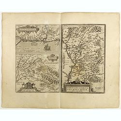
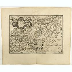
Venuxini Comitatus Nova Descr. / Gallia Narbonensis. / Sabaudiae Ducat.
Three maps on one sheet. Upper left the coast of the Mediterranean Sea (with places like Narbonne, Aigues Mortes, Avignon, Arles etc. In the bottom left corner a map of t...
Date: Antwerp, 1598
Selling price: ????
Please login to see price!
Sold in 2019
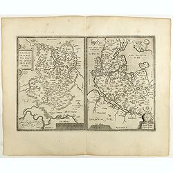
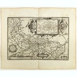
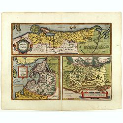
Hassiae Descriptio / Holsatiae Descriptio.
Two maps on one sheet. Left hand presents the province of Hessen, centered on the city of Munich : the right part shows the province of Holstein. Very nice cartouche on t...
Date: Antwerp, 1598
Selling price: ????
Please login to see price!
Sold in 2020
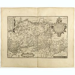
Saxoniae Misniae Thuringiae.
A very fine map of Saxen, Misnie and Thüringen . A very decorative title cartouche on the lower left corner, and a symbolized legend cartouche on the upper right corner....
Date: Antwerp, 1598
Selling price: ????
Please login to see price!
Sold in 2020
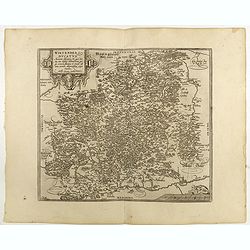
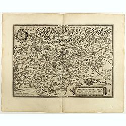
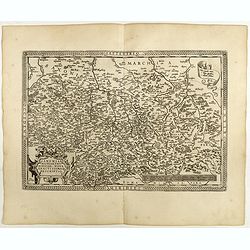
Wirtenberg Ducatus . . .
Ortelius copied the map after Georg Gadner's map of 1572.Very decorative and a masterpiece in the sense of engraving and composition.Abraham Ortelius (1527-1598) was a ca...
Date: Antwerp, 1598
Selling price: ????
Please login to see price!
Sold in 2023
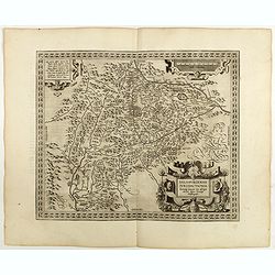
Salisburgensis Iuridictionis.
Prepared by the Salzburg-born cartographer Marcus Secsnagel (1520-1580). Title cartouche on the lower right corner. Abraham Ortelius (1527-1598) was a cartographer and pu...
Date: Antwerp, 1598
Selling price: ????
Please login to see price!
Sold in 2021
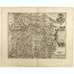
Bavariae, olim vindeliciae delineationis..
Fine and early map of Bavaria, prepared by Philipp Apian in 1561 and used by Ortelius in his atlas 'Theatrum Orbis Terrarum [Atlas of the Whole World]. The Theatrum was r...
Date: Antwerp, 1598
Selling price: ????
Please login to see price!
Sold in 2018
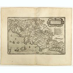
Thusciae descriptio . . .
Very fine map of Tuscany after Girolamo Bellarmati (1493-1555). In lower right hand corner Rome, includes Chianti wine region, Pisa, Florence, etc.Abraham Ortelius (1527-...
Date: Antwerp, 1598
Selling price: ????
Please login to see price!
Sold in 2021
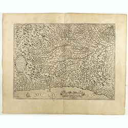
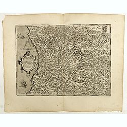
Pedemontanae vicinorumque...
Very fine map of Piemonte after Giacomo Gastaldi (1500-1566). Including towns of Turin, Milan, Genoa, S.Remo, Monaco, etc.Abraham Ortelius (1527-1598) was a cartographer ...
Date: Antwerp, 1598
Selling price: ????
Please login to see price!
Sold in 2018
![Brixiani Agri Typus [Brescia].](/uploads/cache/41011-250x250.jpg)
Brixiani Agri Typus [Brescia].
A very nice map of northern province of Italy, Brecia. Copied after a map prepared in 1560 by Christoforo Sorte. Very large title cartouche on the lower left corner. Abra...
Date: Antwerp, 1598
Selling price: ????
Please login to see price!
Sold in 2018
Agricremonensis Typus
Very decorative map of northern Italy with the city of Cremona near the center. The map is based on the 1571 map of Antonio Campi. Large inset of essentially the same reg...
Date: Antwerp, 1598
Selling price: ????
Please login to see price!
Sold in 2018
Regni Neapolitani verissi..
Very fine map of Southern Italy, including the towns of Ascoli Piceno, Napels, Fogia, Bari, Catanzaro, most northern tip of Sicily with Messina. The map is based on Pirro...
Date: Antwerp, 1598
Selling price: ????
Please login to see price!
Sold in 2022

Aprutii Ulterioris Descriptio.
Very fine map covering Abruzzi area, including the towns of Ascoli Piceno, Teramo, Pescara, etc. Prepared by Natale Bonifacio (1538-1592). Three fine title cartouches. A ...
Date: Antwerp, 1598
Selling price: ????
Please login to see price!
Sold in 2018
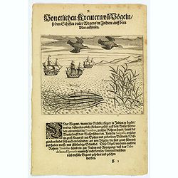
Seaweed and birds seen approaching the Cape of Good Hope.
The sailors saw many plants floating on the surface of the sea during their voyage to India. Among these was the ‘trombas’, which was a pipe-like growth with its root...
Date: Frankfurt, 1598
Selling price: ????
Please login to see price!
Sold in 2019
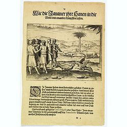
How the Javanese bet on cock-fighting.
The people of Java rear cocks for fighting and put bets on them for high sums of money. The fiercest and strongest birds are taken to an open space where pairs are chosen...
Date: Frankfurt, 1598
Selling price: ????
Please login to see price!
Sold in 2020
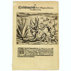
A picture of the Aloë, Maguey mexicanum & Sycomorg.
Here is the aloë, or semper vivum, which is as tall as a man and found in great numbers in Agua de Sanbras. Also the maguey, often called metl, grows here, but originate...
Date: Frankfurt, 1598
Selling price: ????
Please login to see price!
Sold in 2021
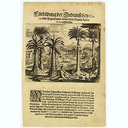
The Indian coconut, fig-tree and others.
The Indians have many uses for the palm or coconut tree. Not only do they obtain food and drink from its fruit, they can also make clothing, ships’ sails, rope and othe...
Date: Frankfurt, 1598
Selling price: ????
Please login to see price!
Sold in 2018
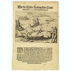
How the inhabitants catch whales off the east coast of Madagascar.
When the natives of Santa Marta, off the east coast of Madagascar see a whale, they row out in their little boats and throw out a rope with a large hook on the end. When ...
Date: Frankfurt, 1598
Selling price: ????
Please login to see price!
Sold in 2022
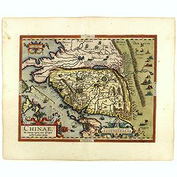
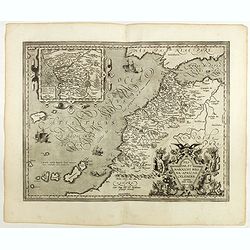
Chinae, olim Sinarum Regionis, nova descriptio. Auctore Ludovico Georgio.
The first map of China ever to appear in a Western atlas, west to the top. The second state with "Las Philipinas" somewhere in 1587 added to the plate. When thi...
Date: Antwerp, 1598
Selling price: ????
Please login to see price!
Sold in 2018
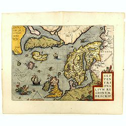
Septentrionalium Regionum Descrip.
This influential map of the Arctic, including Scandinavia, Iceland, Greenland and part of the North American continent, includes also the legendary islands of i.a. Drogeo...
Date: Antwerp, 1598
Selling price: ????
Please login to see price!
Sold in 2018
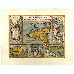
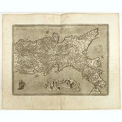
Insularum Aliquot Maris Mediterranei Descriptio.
Six maps on one sheet. In the center a map of Sicily, surrounded by maps of Sardinia, Djerba, The island of Elbe, Corfu and Malta.
Date: Antwerp, 1598
Selling price: ????
Please login to see price!
Sold in 2018
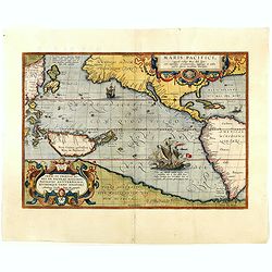
Maris Pacifici.
This was the first printed map to be devoted solely to the Pacific, and the first to name North and South America separately. Lower right a large presentation of Ferdinan...
Date: Antwerp, 1598
Selling price: ????
Please login to see price!
Sold in 2018
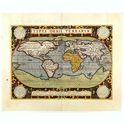
Typus Orbis Terrarum.
Ortelius' third and last world map is dated 1587 under the author's signature. The earlier border of clouds has been replaced by a more intricate and elegant lattice of s...
Date: Antwerp, 1598
Selling price: ????
Please login to see price!
Sold in 2018
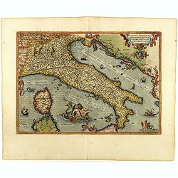
Italiae Novissima descriptio. . .
Very fine map of Italy after Giacomo Gastaldi. Embellished with a title cartouche, vessels, sea monsters and sea gods. No text on verso.Abraham Ortelius (1527-1598) was a...
Date: Antwerp, 1598
Selling price: ????
Please login to see price!
Sold in 2018
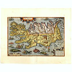
Islandia.
Perhaps the most famous map of Iceland. On the south side of the island a collection of all possible sea monsters is depicted. Polar bears on ice flows and volcanoes in t...
Date: Antwerp, 1598
Selling price: ????
Please login to see price!
Sold in 2018
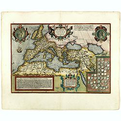
Romani Imperii Imago.
An attractive map of the second plate prepared (after 1592) of the Roman Empire, drawn by Ortelius and published in the 'Paregon' section. The medallion portraits are of ...
Date: Antwerp, 1598
Selling price: ????
Please login to see price!
Sold in 2018
Pomeraniae, Wandalicae Regionis, Typ. - Livoniae Nova Descriptio, Ioanne Portantio auctore. - Ducatus Oswieczensis, et Zatoriensis, Descriptio.
Three maps on one sheet. The first map covers northern part of Pomerania. The map of Livonia is prepared by Johannes Portanius, who was a contemporary of Ortelius who als...
Date: Antwerp, 1598
Selling price: ????
Please login to see price!
Sold in 2018
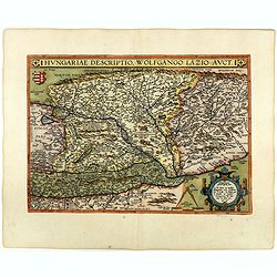
Hungariae Descriptio ..
A very fine map of Hungary, centered on Budapest. The map was prepared by Wolfgang Lazius in 1556. Very decorative cartouche on the lower right corner.Abraham Ortelius (1...
Date: Antwerp, 1598
Selling price: ????
Please login to see price!
Sold in 2018
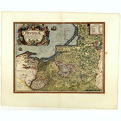
Prussiae descriptio. . .
Fine map of Ortelius' first map of Prussia, with a striking cartouche and two sailing ships, showing part of present day Poland.The map was prepared by Caspar Henneberger...
Date: Antwerp, 1598
Selling price: ????
Please login to see price!
Sold in 2018
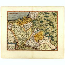
Poloniae, Lituaniaeq descriptio.
Fine general map of Poland. Rare, the second plate appearing in post-1595 edition of the Theatrum. Only used until 1612. Based on the now lost map of Waclaw Grodecki. Sho...
Date: Antwerp, 1598
Selling price: ????
Please login to see price!
Sold in 2018
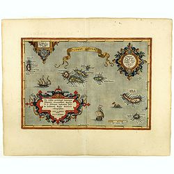
Açores Insulae.
The importance of the Azores at that time was connected with the observation of Columbus that compass variation (i.e. the difference between the real and the magnetic nor...
Date: Antwerp, 1598
Selling price: ????
Please login to see price!
Sold in 2019
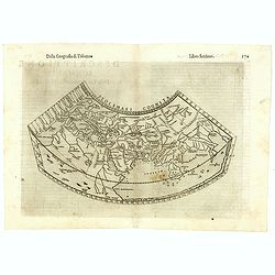
Ptolemaei Cognita.
Fine 1598 edition of this early world map. Girolamo Ruscelli first published the map in his "La Geographi di Claudio Tolomeo" (Venice, 1561), with the present e...
Date: Venice, 1598
Selling price: ????
Please login to see price!
Sold in 2023
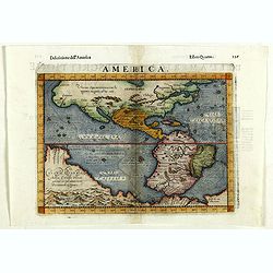
America.
Fine 1598 edition of this early map of America. Girolamo Ruscelli first published the map in his "La Geographi di Claudio Tolomeo" (Venice, 1561), with the pres...
Date: Venice, 1598
Selling price: ????
Please login to see price!
Sold in 2018
![Insulae Philippinae [Philippines].](/uploads/cache/42048-250x250.jpg)
Insulae Philippinae [Philippines].
A miniature map of Philippines, centered on Mindanao and Luzon. Title cartouche on the upper left corner. First published in 1598 in his Caert-Thresoor, the plates were e...
Date: Middelburg, 1598
Selling price: ????
Please login to see price!
Sold in 2018
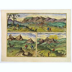
Bornnes / Zahara.
Three fine engravings after G> Hoefnagel, dated 1564 of two towns in the province of Cadiz. The two engravings of the hill-top town of Zahara are taken from the west, ...
Date: Cologne, ca 1598
Selling price: ????
Please login to see price!
Sold in 2020
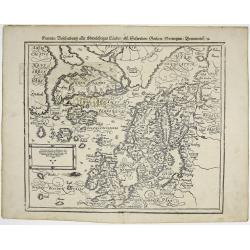
Gemeine Beschreibung aller Mitnachtigen Lander / alss Schweden / Gothen / Norwegien / Denmarck / &c.
Sebastian Münster’s third and final map of Scandinavia including England, Denmark, Norway, Sweden, Iceland, The Baltics, Greenland and America by Sebastian Munster 159...
Date: Basle, 1598
Selling price: ????
Please login to see price!
Sold in 2019
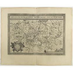
Brandeburgensis Marchiae Descriptio.
A very fine map centered on the towns of Brandenburg and Berlin. Nice title cartouche on the lower left corner.Prepared by Elias Camerius. Abraham Ortelius (1527-1598) wa...
Date: Antwerp, 1598
Selling price: ????
Please login to see price!
Sold in 2018
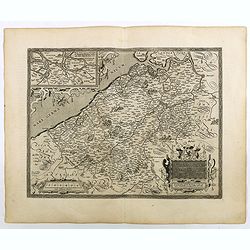
Turingiae Noviss../ Mansfeldiae Comitatus.
Two maps on one sheet. Left hand presents the province of Thüringen and is centered on the city of Erfurt. Nice cartouche on the lower left corner with a credit to the a...
Date: Antwerp, 1598
Selling price: ????
Please login to see price!
Sold in 2020
Franciae Orientalis (Vulgo Franckenlant) Descriptio, Avctore, Sebast.A. Rotenhan. (with) Monasteriensis Et Osnaburgensis Episcopatvs Descriptio Auctore Godefrido Mascop Embricense. Cum privilegio.
The map of Frankenland is prepared by Sebastian Rotenhan (1478-1532) and showing the area between Frankfurt and Bamberg. To the right a map Monasteriensis which is after ...
Date: Antwerp, 1598
Selling price: ????
Please login to see price!
Sold in 2018
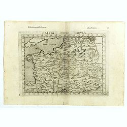
Gallia Nova Tabula.
The third state of Ruscelli's map of France, based upon Claudius Ptolemy. Girolamo Ruscelli first published the map in his "La Geographi di Claudio Tolomeo" (Ve...
Date: Venice, 1598
Selling price: ????
Please login to see price!
Sold in 2018
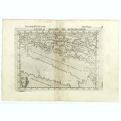
Tavola nuova di Schiavonia.
The third state of Ruscelli's map of the Balkans, with a coat of arms in lower left corner, based upon Claudius Ptolemy. Girolamo Ruscelli first published the map in his ...
Date: Venice, 1598
Selling price: ????
Please login to see price!
Sold in 2018