Browse Listings
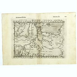
Africa minor nuova tavola.
The third state of Ruscelli's map of North Africa, based upon Claudius Ptolemy. Showing the region of present day Algiers, Tunisia and Libya. Girolamo Ruscelli first publ...
Date: Venice, 1598
Selling price: ????
Please login to see price!
Sold in 2018
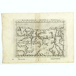
Marmarica nuova tavola.
The third state of Ruscelli's map of northern Africa based upon Claudius Ptolemy. Showing the Nubia Desert and showing Egypt, the Nile, etc. Girolamo Ruscelli first publi...
Date: Venice, 1598
Selling price: ????
Please login to see price!
Sold in 2018
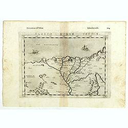
Egito vuova tavola.
The third state of Ruscelli's map of Egypt with the river Nile, based upon Claudius Ptolemy. Showing Egypt and the Nile. Extends east to the Upper Red Sea and West to Des...
Date: Venice, 1598
Selling price: ????
Please login to see price!
Sold in 2018
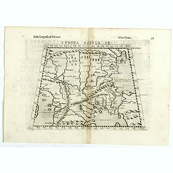
Europae tabula IX.
The third state of Ruscelli's map of The Balkans region, based upon Claudius Ptolemy. Showing the Balkans and Turkey. Girolamo Ruscelli first published the map in his &qu...
Date: Venice, 1598
Selling price: ????
Please login to see price!
Sold in 2018
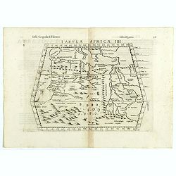
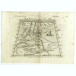
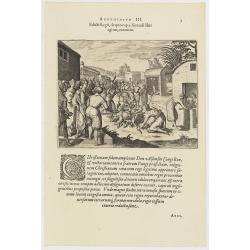
Tabula Africae III.
The third state of Ruscelli's map of North Africa and the Mediterranean, based upon Claudius Ptolemy. Showing the north coast of Africa including Egypt and the Nile River...
Date: Venice, 1598
Selling price: ????
Please login to see price!
Sold in 2018
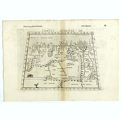
Tabula Africae IIII.
The third state of Ruscelli's map of The Northern part of Africa, based upon Claudius Ptolemy. Showing Mediterranean, Aethiopia Interior, the Canary Islands, Asia Minor, ...
Date: Venice, 1598
Selling price: ????
Please login to see price!
Sold in 2018
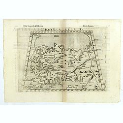
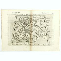
Tabula Asiae I.
The third state of Ruscelli's map of Turkey, based upon Claudius Ptolemy. Showing Asia Minor and parts of the Black Sea and Cyprus. Girolamo Ruscelli first published the ...
Date: Venice, 1598
Selling price: ????
Please login to see price!
Sold in 2018
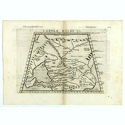
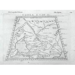
Tabula Asiae II.
The third state of Ruscelli's map of part of the Ukraine and the region between the Black Sea and Caspian Sea extending south to include all of Armenia Maior and part of ...
Date: Venice, 1598
Selling price: ????
Please login to see price!
Sold in 2018
Tabula Asiae III.
The third state of Ruscelli's map of the region between the Black Sea and Caspian Sea extending south to include all of Armenia Maior and part of Armenia Minoris, based u...
Date: Venice, 1598
Selling price: ????
Please login to see price!
Sold in 2018
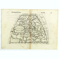
Tabula Asiae VII.
The third state of Ruscelli's map the region north and east of the Black Sea and Caspian Sea, extending to the Imaus Mountains, based upon Claudius Ptolemy. Showing Caspi...
Date: Venice, 1598
Selling price: ????
Please login to see price!
Sold in 2018
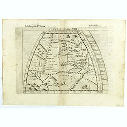
Tabula Asiae VIII.
The third state of Ruscelli's map of central Asia, based upon Claudius Ptolemy. Girolamo Ruscelli first published the map in his "La Geographi di Claudio Tolomeo&quo...
Date: Venice, 1598
Selling price: ????
Please login to see price!
Sold in 2018
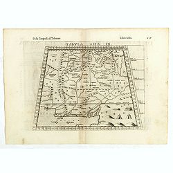
Tabula Asiae IX.
The third state of Ruscelli's map of part of Northern India, based upon Claudius Ptolemy. Showing India, Pakistan and the Indian Ocean. Girolamo Ruscelli first published ...
Date: Venice, 1598
Selling price: ????
Please login to see price!
Sold in 2018
Tabula Asiae X.
The third state of Ruscelli's map of part of India and the Indian Ocean, based upon Claudius Ptolemy. Showing part of India and the Indian Ocean, extending north to the s...
Date: Venice, 1598
Selling price: ????
Please login to see price!
Sold in 2018
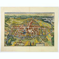
![Wiismaria [Wismar].](/uploads/cache/42766-250x250.jpg)
Wiismaria [Wismar].
Wismar is here shown in a cavalier perspective. The former Hanseatic city on the Baltic rises on the far side of Wismar Bay beyond a broad reach of land. The impressive s...
Date: Cologne, 1598
Selling price: ????
Please login to see price!
Sold in 2020
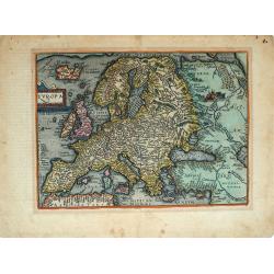
Europa.
Fascinating, scarce early map of the Europe from Quad's Europae totius orbis terrarum, published by Johann Bussemacher. Quad's map is a fantastic amalgam of many cartogr...
Date: Cologne, 1598
Selling price: ????
Please login to see price!
Sold in 2019
Heide / Meldorf.
Twin perspective bird's-eye views of Heide and Meldorf. HEIDE: The town of Heide is presented in a bird's-eye view from the south. The houses are arranged around the larg...
Date: Cologne, 1598
Selling price: ????
Please login to see price!
Sold in 2019
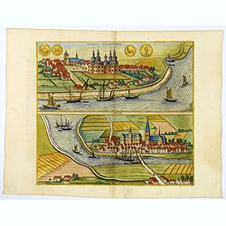
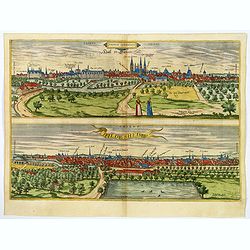
Tonning / Husum.
A pair of bird's-eye perspective views. TONNING: The illustration of Tönning shows a view across the Eider. The castle with five towers at the center of the town was bui...
Date: Cologne, 1598
Selling price: ????
Please login to see price!
Sold in 2019
Odense.
The Danish city of Odense is presented in a sweeping panorama seen in a bird's-eye view from the south. The River Odense winding its way across the landscape flows into t...
Date: Cologne, 1598
Selling price: ????
Please login to see price!
Sold in 2020
Halle / Hildesheim.
A pair of bird's eye perspective Views of Halle & Hildesheim. Halle is presented in a view across the Saale from the west. Particularly prominent on the skyline - hal...
Date: Cologne, 1598
Selling price: ????
Please login to see price!
Sold in 2020
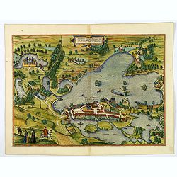
Plon.
Plön is shown in a sweeping bird's-eye view of the countryside surrounding the Greater and Lesser Lake Plön, on which a number of fishermen are seen at work. The palace...
Date: Cologne, 1598
Selling price: ????
Please login to see price!
Sold in 2020
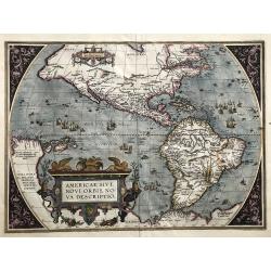
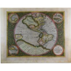
Americae sive Novi Orbis Nova Descriptio (Dutch text edition).
One of the most famous and decorative maps of America.The map, which shows both North and South America, featured in Abraham Ortelius' Theatrum Orbis Terrarum, the first ...
Date: Antwerp, (1587) 1598
Selling price: ????
Please login to see price!
Sold in 2019
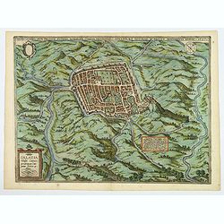
Calatia vulgo Caiazo.
The well-fortified town of Caiazzo (also called the Città dell'Olio, "City of Oil"), which lies northeast of Capua in the immediate vicinity of the Vilturno, i...
Date: Cologne, ca 1598
Selling price: ????
Please login to see price!
Sold in 2020
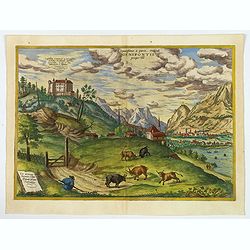
Elegantissimus a parte Orientali Oenipontis prospectus.
This engraving offers a view of the Inn Valley from the east. In its animation and dynamism, conveyed by the rural staffage, high mountains and dramatic, cloudy sky, the ...
Date: Cologne, 1598
Selling price: ????
Please login to see price!
Sold in 2020
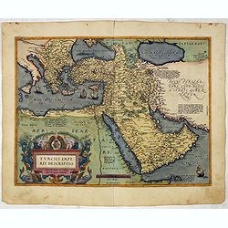
Turcici Imperii Descriptio.
Map of the Middle East, extending from Greece to Arabia and covering the Cradle of Civilisation region. This is a new plate copied from another Ortelius map of 1570 with ...
Date: Antwerp, 1598
Selling price: ????
Please login to see price!
Sold in 2022
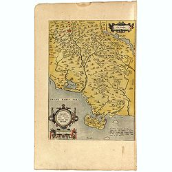
Senensis ditionis, Accurata descript.
Map by Ortelius of Tuscan Sea, with Siena in upper left corner. The map was based on a map of Caesar Orlandi.In attractive original colors. From 'Theatrum Orbis Terrarum ...
Date: Antwerp, 1598
Selling price: ????
Please login to see price!
Sold in 2019
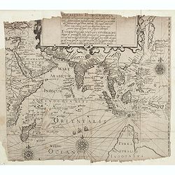
Descriptio Hydrographica accommodata ad Battavorum navagatio
The German writer Levinas Hulsius compiled an extensive collection of accounts of explorers' voyages, published ultimately in twenty-six parts. This handsome map sets out...
Date: Nuremberg 1598
Selling price: ????
Please login to see price!
Sold in 2019
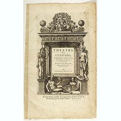
Theatre de l'Univers, contenant les Cartes de tout le Monde, avec une brieve Declaration d'icelles.
A very decorative title page from the 1598 French edition of Ortelius' Theatrum Orbis Terrarum, the first modern Atlas.
Date: Antwerp, 1598
Selling price: ????
Please login to see price!
Sold in 2019
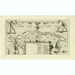
Fretum Magellannicum, und dessen eigentliche Beschribung, so die hollander durch schifft und aush der leng beschreiben.
A fascinating early map of the Strait of Magellan, with north at the bottom, showing ships sailing the passageway between Terrae del Fuogo Pars and Americae Pars. Depicte...
Date: Frankfurt, 1599
Selling price: ????
Please login to see price!
Sold in 2012

Franciscus Draco cum in locum quendam venis set, à Rege istius regionis convenitur.
This famous and desirable scene was engraved by de Bry native Americans approaching European soldiers and offer gifts. A group of native Americans sit around a fire in a ...
Date: Frankfurt, Matthaeus Becker, 1599
Selling price: ????
Please login to see price!
Sold in 2014
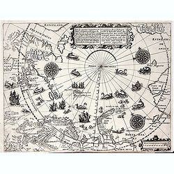
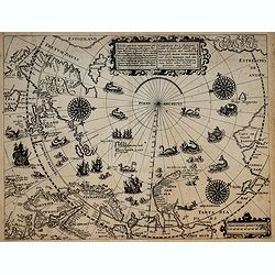
Deliniatio cartae trium navigationum per Batavos. . .
A major landmark in Arctic cartography incorporating recent voyages including Barents' third voyage to this region, made in 1596-7. A derivative of Willem Barentsz's map ...
Date: Frankfurt, 1599
Selling price: ????
Please login to see price!
Sold in 2012
![[Portrait of Jan Huijgen van Linschoten.]](/uploads/cache/34185-250x250.jpg)
[Portrait of Jan Huijgen van Linschoten.]
Rare head and shoulder portrait of the famous explorer Jan Huijgen van Linschoten. The portrait medallion has an oval frame of simulated metal upon which is engraved Lins...
Date: Frankfurt, 1599
Selling price: ????
Please login to see price!
Sold in 2014
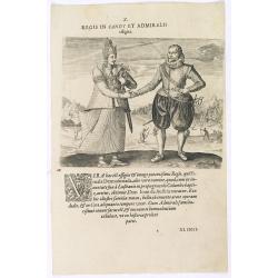
Regis in candt et Admiralis effigies. (The king of Candy meets the Dutch Admiral)
This shows the mighty king who received the name: Fimala Derura Suriada as a child in Colombo. He was also christened Don Lean d'Austria do Colombo. He is of royal blood ...
Date: Frankfurt, 1599
Selling price: ????
Please login to see price!
Sold in 2016
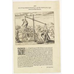
XIV. Festum Poenitentiae Apud Populos, Qui. . . ( Strange ceremonies in the state of Silon.)
Strange ceremonies in the state of Silon. Among the Oriental Indians are several from Casta who, whenever a man dies, digs a large pit. Then the corpse is placed in the o...
Date: Frankfurt, 1599
Selling price: ????
Please login to see price!
Sold in 2018
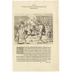
XVIII. Pugna Inter Regem in Pegu . . . [A battle between King Pegu and King Auua)
Battle with two elephants between King Pegu and King Auua. After King Pegu had burnt the traitors, he gathered together three hundred thousand men and declared war on Kin...
Date: Frankfurt, 1599
Selling price: ????
Please login to see price!
Sold in 2016
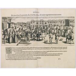
De foro Goae frequentao, Leylon. . . (The daily market at Goa).
This famous and desirable scene of the daily market of Goa, drawn after Jan Huijgen van Linschoten during his visit to the East of 1583-1592 here published by De Bry the ...
Date: Frankfurt, 1599
Selling price: ????
Please login to see price!
Sold in 2020
Tabula Asiae II
An interesting Ptolemaic map with trapezoidal projection. Shows the Caucasus region from the modern-day Crimea and Sea of Azov, to the mouth of the Volga River and the Ca...
Date: Venice, 1599
Selling price: ????
Please login to see price!
Sold in 2016
Deliniatio cartae trium navigationum per Batavos..
A major landmark in Arctic cartography incorporating recent voyages including Barents' third voyage to this region, made in 1596-7. A derivative of Willem Barentsz's map ...
Date: Frankfurt, 1599
Selling price: ????
Please login to see price!
Sold in 2017
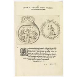
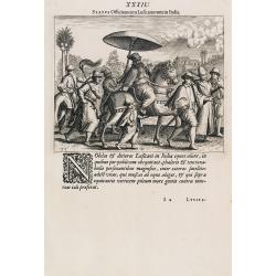
XI. Insignia et Sigilla Regum in Celon.
Theodore de Bry, a German engraver and book dealer, began a compilation of early voyages in 1590 and had published six parts at the time of his death in 1598. His widow, ...
Date: Frankfurt, 1599
Selling price: ????
Please login to see price!
Sold in 2018
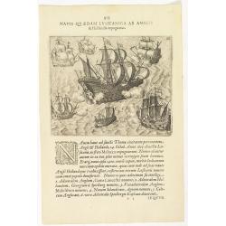
Navis Quaedam Lusitanica ab Anglis. . . (The English and Dutch attack a Portuguese ship )
A nice engraving of a battle between Dutch, English and Portuguese ships (137 x 167mm.) with a numbered key. According to the Latin explanation "On the 14th October,...
Date: Frankfurt, 1599
Selling price: ????
Please login to see price!
Sold in 2018
Edicti Regii, de quo cap. 3 fecundi libri agitur, executio. (How the king of the Congo had all the devilish idols burnt )
How the king of the Congo had all the devilish idols burnt. After the king of the Congo adopted the Christian religion, he told all his noblemen and servants to hand over...
Date: Frankfurt, 1598-1599
Selling price: ????
Please login to see price!
Sold in 2017
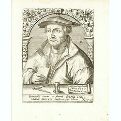
Sebastianus Munsterus Cosmographus.
Very decorative portrait of Sebastian Münster (20 January 1488 – 26 May 1552), engraved by Theodor de Bry (1528-1593) and published in Jean Jacques Boissard, "Ico...
Date: Frankfurt a.M. 1597 - 1599
Selling price: ????
Please login to see price!
Sold in 2017
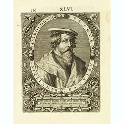
Petrus Apianus Binvitzius Astrologus
Very decorative portrait of Petrus Apianus (April 16, 1495 – April 21, 1552), engraved by Theodor de Bry (1528-1593) and published in Jean Jacques Boissard, "Icone...
Date: Frankfurt a.M. 1597 - 1599
Selling price: ????
Please login to see price!
Sold in 2021
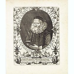
Guliemus Camdenus historicus Brittannus.
Very decorative portrait of William Camden (2 May 1551 – 9 November 1623), engraved by Theodor de Bry (1528-1593) and published in Jean Jacques Boissard, "Icones V...
Date: Frankfurt a.M. 1597 - 1599
Selling price: ????
Please login to see price!
Sold in 2017
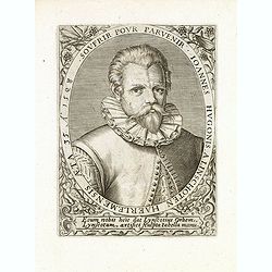
Johannes Hugonis a Linschoten Haerlemensis aeta 35 A° 1598 Soufrir pour parvenir.
Very decorative portrait of Jan Huyghen van Linschoten (1563, Haarlem – 8 February 1611, Enkhuizen), engraved by Theodor de Bry (1528-1593) and published in Jean Jacque...
Date: Frankfurt a.M. 1597 - 1599
Selling price: ????
Please login to see price!
Sold in 2018
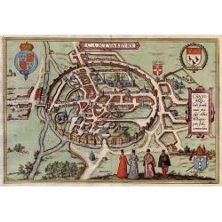
Cantuarbury.
A beautifully rendered and decorative bird's-eye view of the famous English town of Canterbury. The plan identifies important sites and contains four coats-of-arms along ...
Date: Cologne, 1599
Selling price: ????
Please login to see price!
Sold in 2017
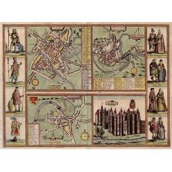
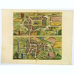
Yorke - Shrowesbury - Lancaster - Richmont.
Four city plans by Braun & Hogenberg on one sheet : Plans of York, Shrewsbury and Lancashire and a view of the castle of Richmond.On each side of the four views are ...
Date: Cologne, 1599
Selling price: ????
Please login to see price!
Sold in 2017
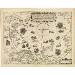
Deliniatio cartae trium navigationum per Batavos..
A major landmark in Arctic cartography incorporating recent voyages including Barents' third voyage to this region, made in 1596-7. A derivative of Willem Barentsz's map ...
Date: Frankfurt 1599
Selling price: ????
Please login to see price!
Sold
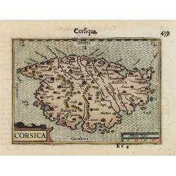
CORSICA.
A miniature map of Corsica.First published in 1598 in his Caert-Thresoor, the plates were executed by the most famous engravers in Amsterdam, including Petrus Kaerius and...
Date: Amsterdam/Frankfurt 1599
Selling price: ????
Please login to see price!
Sold
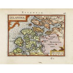
Zelandia.
Map of the Province of Zeeland, with its many islands and peninsulas. Major cities, small villages.
Date: Amsterdam 1599
Selling price: ????
Please login to see price!
Sold
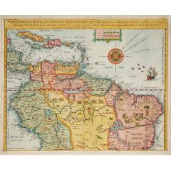
Nova Et Exacta Delineatio Americae Partis Australis Que Est : Brasilia, Caribana, Guiana ?
Very rare map of South America, published by Hulsius. First issue. One of the two maps of Central and South América published in "Brevis & admiranda descriptio ...
Date: Nuremberg 1599
Selling price: ????
Please login to see price!
Sold in 2010
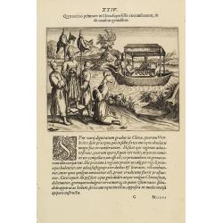
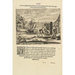
Floating Tea House in China.
This famous and desirable scene from Linschoten's famous voyages to the East of 1583-1592 here published by De Bry the year after they first appeared as a separate book. ...
Date: Frankfurt, 1599
Selling price: ????
Please login to see price!
Sold in 2012
Transport of China
Scene of a "Chinese" landscape with a wind carriage and the transportation of a noble woman from Linschoten's famous voyages to the East of 1583-92 here publish...
Date: Frankfurt, 1599
Selling price: ????
Please login to see price!
Sold in 2013
Mirae Chinensium ceremoniae, quibus in sacris & diuino cultu vtuntur.
A religious scene in China Linschoten's famous voyages to the East of 1583-92 here published by De Bry the year after they first appeared as a separate book. From Part II...
Date: Frankfurt, 1599
Selling price: ????
Please login to see price!
Sold in 2021
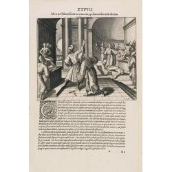
Status Officiatorum Lusitanorum in India.
A scene of Portuguese officials in India from Linschoten's famous voyages to the East of 1583-1592 here published by De Bry the year after they first appeared as a separa...
Date: Frankfurt, 1599
Selling price: ????
Please login to see price!
Sold in 2013
A Ilha e Cidade de Goa Metropolitana da India e Partes Orientais que esta em 15 Graos da Banda do Norte.
A bird's-eye town-plan of Goa, the capital of the Portuguese trading empire in Asia. This is a reduced version of Doetechum's view that illustrated editions of Jan Huygen...
Date: Frankfurth, 1599
Selling price: ????
Please login to see price!
Sold in 2013
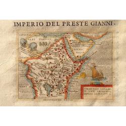
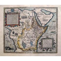
Imperio Del Preste Gianni - Presbeteri Ioannis Sive Abissinorum Imperii Descriptio.
Charming map of the legendary land of the Christian king, Prester John, inset in Italian text (recto and verso). From "La seconda parte delle relazioni universali&qu...
Date: Breschia c. 1599
Selling price: ????
Please login to see price!
Sold in 2011
![[No Title] - This is the frontispiece of De Bry's work of America Parts VIII.](/uploads/cache/83299-250x250.jpg)
[No Title] - This is the frontispiece of De Bry's work of America Parts VIII.
This is a very rare opportunity to collect a solo example of De Bry's famous master work's world map - title page of: Americae pars VIII. : Continens primo, Descriptionem...
Date: Frankfurt, 1599
Selling price: ????
Please login to see price!
Sold in 2020

Johannes Hugonis a Linschoten Haerlemensis aeta 35 A° 1598 Soufrir pour parvenir.
Very decorative portrait of Jan Huyghen van Linschoten (1563, Haarlem – 8 February 1611, Enkhuizen), engraved by Theodor de Bry (1528-1593). Jan Huyghen van Linschoten ...
Date: Frankfurt a.M. 1597 - 1599
Selling price: ????
Please login to see price!
Sold in 2020
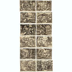
(12 Month's of the year)
Complete set of the 12 month's after Joan Anthony de Pauli (Giovanni Antonio de Paoli, c. 1589-1630) and etched by Antonio Tempesta, also called il Tempestino, (1555 – ...
Date: Rome, 1599
Selling price: ????
Please login to see price!
Sold in 2020
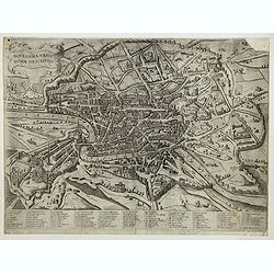
Novissima Urbis Romae Descriptio.
First state. A rare bird's-eye-view of Rome from the Lafreri-School. Numbered key below the view with 86 references. It is inspired by the plan created by Ambrogio Brambi...
Date: Sienne, 1600
Selling price: ????
Please login to see price!
Sold
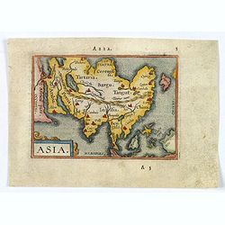
Asia.
A lovely miniature version of the Ortelius map of Asia, complete with a strap-work title and a stippled sea. Map extent is from East Africa to Japan (no Korea), and down ...
Date: Antwerp, ca 1600
Selling price: ????
Please login to see price!
Sold in 2020
![[Lot of 3 portraits, with a portrait of Abraham Ortelius and portraits of William Camden and Robert Dudley]](/uploads/cache/85094-250x250.jpg)
[Lot of 3 portraits, with a portrait of Abraham Ortelius and portraits of William Camden and Robert Dudley]
A striking portrait of Abraham Ortelius, This portrait of Abraham Ortelius appeared in the editions of his ‘Theatrum’ published after his death in 1598. Abraham Ortel...
Date: Antwerp, ca 1600
Selling price: ????
Please login to see price!
Sold in 2022
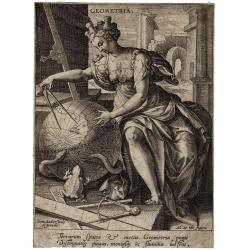
Geometrica.
Geometrica, engraving by Joan Sadeler (1550-1600), after Maerten de Vos (1532-1603). One fo the seven liberal arts.
Date: Antwerp, 1570-1600
Selling price: ????
Please login to see price!
Sold in 2021
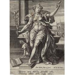
Rhetorica.
Rhetorica, engraving by Joan Sadeler (1550-1600),after Maerten de Vos (1532-1603). One of the seven liberal arts.
Date: Antwerp, 1570-1600
Selling price: ????
Please login to see price!
Sold in 2021
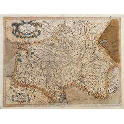
Aquitania australis regnu Arelatense cum confinijs
Early map of southern France, extending until Monaco, parts of Spain and Switzerland. Published in Mercators famous Atlas Sive Cosmographia. Latin text on verso.
Date: Amsterdam, ca. 1600
Selling price: ????
Please login to see price!
Sold in 2022
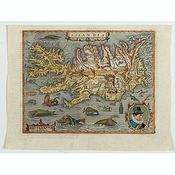
Islandia.
Quad's : reduced in size Ortelius´ map, of Iceland. With German text on verso, from Geographisch Handtbuch. Signed by the engraver Johan Bussemacher.Matthias Quad was o...
Date: Cologne, 1600
Selling price: ????
Please login to see price!
Sold in 2023
ANVERS
Uncommon copper engraved plan of Antwerp, with the harbor, the fortifications, and the surrounding area. Latin text on verso. Shows the streets and city walls, plus fiel...
Date: Amsterdam, 1600
Selling price: ????
Please login to see price!
Sold in 2012
Der Candinal vor Hulst Komt An...
A very fine copper engraving of the attack of Hulst, showing the military strengths of opposing forces. Attack by Archduke Albert Von Austria, governor of the Netherlands...
Date: Cologne, ca. 1600
Selling price: ????
Please login to see price!
Sold in 2018
Presbiteri Iohannis, sive, Abissinorum Imperii descriptio.
Famous "Prester John" map of most parts of the African continent, and the Arabian peninsula. With a dedication to King David, and the coat of arms of Preste...
Date: Antwerp, c1600
Selling price: ????
Please login to see price!
Sold in 2013
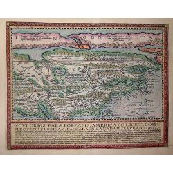
Novi Orbis Pars America. . .
Published in Cologne in 1600 this map is from 'Geographisch Handtbuch' with German text on the verso.Quad's map of North America is derived from De Jode and is a beautifu...
Date: Cologne, 1600
Selling price: ????
Please login to see price!
Sold in 2013
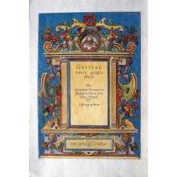
Galliae tabule geographicae. Per Gerardum Mercatorem...
Attractive titlepage of the France volume from Mercator's Atlas Sive Cosmographia. According to Shirley the "early sectional parts of his "Atlas" each had ...
Date: Amsterdam, c1600
Selling price: ????
Please login to see price!
Sold in 2014
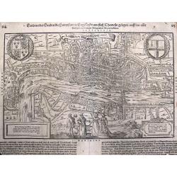
Londen oder Lunden (Londinum Feracis: Ang. Met.).
Superb bird's-eye view of London based on the Braun & Hogenberg view. Shows the area between Clerkenwell, Wapping, Southwark and Westminster Abbey. Elizabethan costum...
Date: Basle, c1600
Selling price: ????
Please login to see price!
Sold in 2013
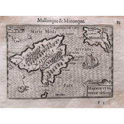
Majorcae et Minorcae descrip.
Superb miniature map of the Balearics. Including a sailing ship, sea monsters, and the title cartouche. With French text on verso.Published in his "Caert-Thresoor&qu...
Date: Amsterdam, c. 1600
Selling price: ????
Please login to see price!
Sold in 2017
Moscoviae Imperium.
Early map of Imperial Russia and Ukraine by Mathias Quad, published by Johann Bussemacher and Wilhelm Lützenkirchen. It shows the Russian Empire in Europe from the Mare...
Date: Cologne, 1600
Selling price: ????
Please login to see price!
Sold in 2014
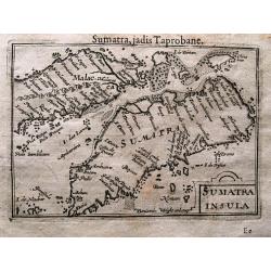
SUMATRA INSULA.
Superb miniature map of Sumatra and southern Malaysia (including Singapore). One of the earliest obtainable maps of the Strait of Malacca naming Singapore. With French te...
Date: Amsterdam, c. 1600
Selling price: ????
Please login to see price!
Sold in 2014
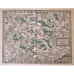
Tabula Geographica Provinciarum Brabantiae, Geldriae, Comitatus sutphaniae, Trajectini, Transilvaniae, Drentiae, Twentiae, Hollandiae et Frisiae.
One of the rarest maps covering a large part of the Netherlands, engraved by Benjamin Wright and published by Cornelis Claesz. Schilder mentions only one other know copy ...
Date: Amsterdam, c.1600
Selling price: ????
Please login to see price!
Sold in 2014
Vera Designatio Urbis in Littavia Grodnae.
Shows a view of the city of Hrodna (Grodno. Different groups of people are crossing the wooden bridge and entering the city.After an engraving by Matthias Zündt, dated 1...
Date: Cologne, c. 1600
Selling price: ????
Please login to see price!
Sold in 2014
America Sive India Nova.
The famous Michael Mercator hemispherical Americas map of 1595, based on his grandfather Rumold Mercator's world map. One of the most important and beautifully engraved e...
Date: Amsterdam, c.1600
Selling price: ????
Please login to see price!
Sold in 2014
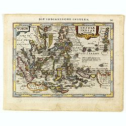
Insulae Indiae Orientalis.
One of the most decorative maps of the Indonesian Archipelago, including the Philippines, Malaya and further India. Signed in the plate bottom left, P. Kaerius Calavit.
Date: Amsterdam, c.1600
Selling price: ????
Please login to see price!
Sold in 2016
![Natolia Olim Sive Asia Minor. [shows Cyprus]](/uploads/cache/35957-250x250.jpg)
Natolia Olim Sive Asia Minor. [shows Cyprus]
A nice example of Mathias Quad's map of Asia Minor and Cyprus. Latin text beneath and to verso of map. A good early map of the region in good condition. Engraved by Johan...
Date: Cologne, 1600
Selling price: ????
Please login to see price!
Sold in 2015