Subscribe to be notified if similar examples become available.
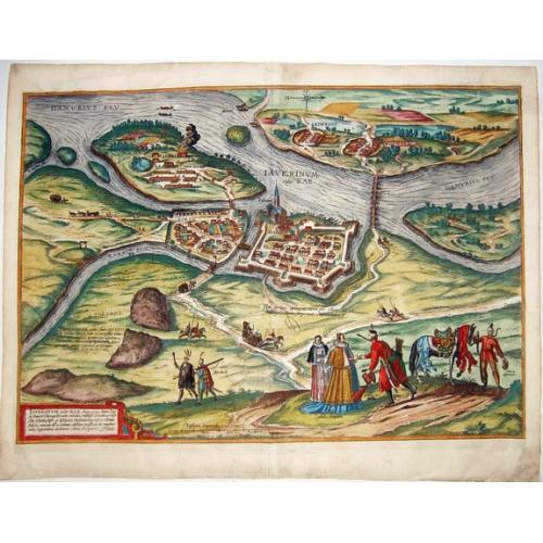
Iaverinum vulgo Rab Anno 1594. [Gyor]. |
||||||||||||||||||||
|
||||||||||||||||||||
|
|
||||||||||||||||||||
|
Selling price: $ Please login to see price!
Sold in 2021 Missed this item! Add your name to our mailing list and be the first to get notified about our newly added listings. . |
Collection - Save and collect this or any of your favorite items in one place.
If you want to save the items permanently, please sign in or create account first. |
|||||||||||||||||||
Description
A plan of Györ after a sketch by Nicolao Aginelli of 1566, redrawn by Joris Hoefnagel for the fifth volume of the 'Civitates Orbis Terrarum', the first systematic atlas of town plans.
In this volume were many plates illustrating events in the recent wars between the Holy Roman Empire and the Ottomans. Although Braun's text describes the fortifications as 'impregnable', the title (lower left) tells how Györ was taken by the Ottomans in 1594 and held for four years.
The situation of the city is reflected in the staffage: in the foreground are 'Heyducks' (mercenaries), a Polish knight (with arrows protruding from his shoulders) and a captured Turk with a horse with an ornamental saddle.
From: 'Civitates Orbis Terrarum', ... Part 5. Köln, 1598. The Civitates Orbis Terrarum (Atlas of Cities of the World) by Hogenberg was the second oldest printed atlas in the history of the world cartography, and the first atlas of towns. Its principal creators and authors were the theologist and editor Georg Braun, the most important engraver and publisher Franz Hogenberg, the engraver Simon van den Neuvel, the artist and draftsman Georg (Joris) Hoefnagel, the topographer Jacob van Deventer and others.
Although published outside the Netherlands, the Civitates is, nevertheless, one of the best examples of the work of the Antwerp school of cartographers. Some of the key figures in the school were Abraham Ortelius, Gerardus Mercator, and a number of other geographers. The Civitates reflects the Flemish style of engraving which was typical of Dutch atlases of the period.
In addition, the correspondence between Braun, Hogenberg, and Ortelius contains clear indications that the idea to create the atlas was formulated by them in Antwerp.
The more than 500 maps, contained in the atlas, represent an entire era in the history of town-mapping. Six volumes of the atlas were published between 1572 and 1617. In order to obtain the originals for his work, Braun corresponded extensively with map sellers and scholars from different cities and countries.
In addition, authors carried out their own investigations. However, these were not true geodetic surveys, but detailed on-location drawings of panoramic views of the towns made from some high point. Most of the engravings, that decorate the Civitates from its first volume to its last, were made from such drawings by Georg Hoefnagel. Hoefnagel drew the images of many towns in France, Italy, England, and Spain. He and his son Jacob subsequently created representations of Austrian and Hungarian towns for the Civitates.
Besides such overview plans, the atlas includes also more detailed maps based on topographic surveys, and particularly the surveys of Jacob van Deventer (15??-1575). Correspondingly, the maps show the systematic structure of the towns' building up with the perspective representation of various quarters and individual buildings.
More about Braun and Hogenberg, Civitatus [+]
Reference: Van der Krogt IV, 1663.
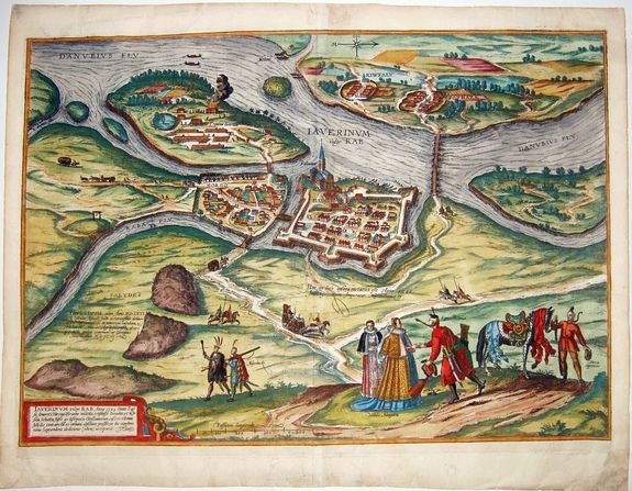
FAQ - Guarantee - Shipping
Buying in the BuyNow Gallery
This item is available for immediate purchase when a "Add to Cart" or "Inquire Now" button is shown.
Items are sold in the EU margin scheme
Payments are accepted in Euros or US Dollars.
Authenticity Guarantee
 We provide professional descriptions, condition report (based on 45 years experience in the map business)
Paulus Swaen warrants the authenticity of our items and a certificate of authenticity is provided for each acquired lot.
Condition and Coloring
We indicate the condition of each item and use our unnique HiBCoR grading system in which four key items determine a map's value: Historical Importance, Beauty, Condition/Coloring and Rarity.
Color Key
We offer many maps in their original black and white condition. We do not systematically color-up maps to make them more sellable to the general public or buyer.
Copper engraved or wood block maps are always hand colored. Maps were initially colored for aesthetic reasons and to improve readability. Nowadays, it is becoming a challenge to find maps in their original colors and are therefor more valuable.
We use the following color keys in our catalog:
Original colors; mean that the colors have been applied around the time the map was issued.
Original o/l colors; means the map has only the borders colored at the time of publication.
Colored; If the colors are applied recently or at the end of the 20th century.
Read more about coloring of maps [+]
Shipping fee
A flat shipping fee of $ 30 is added to each shipment by DHL within Europe and North America. This covers : International Priority shipping, Packing and Insurance (up to the invoice amount).
Shipments to Asia are $ 40 and rest of the world $50
We charge only one shipping fee when you have been successful on multiple items or when you want to combine gallery and auction purchases.
Read more about invoicing and shipping
FAQ
Please have a look for more information about buying in the BuyNow gallery
Many answers are likely to find in the general help section.
Collection
![]()
With Collection you can collect all your favorite items in one place. It is free, and anyone can create his or her Virtual map collection.
Unless you are logged in, the item is only saved for this session. You have to be registed and logged-in if you want to save this item permanently to your Virtual Collection.
Read More[+]
Register here, it is free and you do not need a credit card.
Add this item to
Virtual Collection
or click the following link to see my Collection.
| Digital Image Download | |
|
Paulus Swaen maintains an archive of most of our high-resolution rare maps, prints, posters and medieval manuscript scans. We make them freely available for download and study. Read more about free image download |
Click the image for a free small image download. |
![Rare, antique map of Iaverinum vulgo Rab Anno 1594. [Gyor].](/uploads/85304.jpg)
In accordance with the EU Consumer Rights Directive and habitually reside in the European Union you have the right to cancel the contract for the purchase of a lot, without giving any reason.
The cancellation period will expire 14 calendar days from the day after the date on which you or a third party (other than the carrier and indicated by you) acquires, physical possession of the lot. To exercise the right to cancel you must inform Paulus Swaen Inc, of your decision to cancel this contract by a clear statement (e.g. a letter sent by post, or e-mail (amsterdam@swaen.com).
To meet the cancellation deadline, it is sufficient for you to send your communication concerning your exercise of the right to cancel before the cancellation period has expired.
