Browse Listings
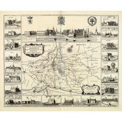
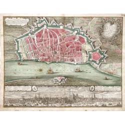
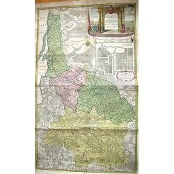
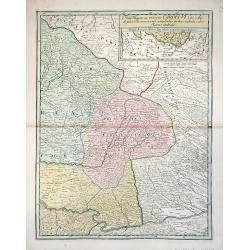
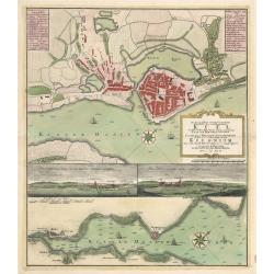
Nova et exacta tabula geographica Salae et Castellaniae Iprensis Anno MDCXXXXI
A "carte à figures"-map the Dioceses of Ypres, with the towns of Ypres and Roeselare. With a panoramic view of the town in top and 20 vignettes of buildings at...
Date: The Hague, Chr. Van Lom, 1732/1735
Selling price: ????
Please login to see price!
Sold in 2011
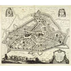
Alostum Vulgo Aelst.
Detailed plan of Aalst from Verheerlijkt Vlaanderen or Flandria Illustrata, engraved by R.Blokhuyse. The author was Antonius Sanderus [Anton Sander] (1586 -1664) who stud...
Date: The Hague, Chr. Van Lom, 1732/1735
Selling price: ????
Please login to see price!
Sold in 2011
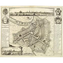
Teneramonda vulgo Dendermonde.
Detailed plan of Dendermonde from Verheerlijkt Vlaanderen or Flandria Illustrata, engraved by R.Blokhuyse. The author was Antonius Sanderus [Anton Sander] (1586 -1664) wh...
Date: The Hague, Chr. Van Lom, 1732/1735
Selling price: ????
Please login to see price!
Sold in 2011
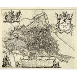
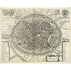
Gandavum Vulgo Gent.
Detailed plan of Gent from Verheerlijkt Vlaanderen or Flandria Illustrata, engraved by R.Blokhuyse. The author was Antonius Sanderus [Anton Sander] (1586 -1664) who studi...
Date: The Hague, Chr. Van Lom, 1732/1735
Selling price: ????
Please login to see price!
Sold in 2011
Ypra. (Ypre)
Detailed plan of Ypres from Verheerlijkt Vlaanderen or Flandria Illustrata, engraved by R.Blokhuyse. The author was Antonius Sanderus [Anton Sander] (1586 -1664) who stud...
Date: The Hague, Chr. Van Lom, 1732/1735
Selling price: ????
Please login to see price!
Sold in 2011
Brugge.
Detailed plan of Bruges from Verheerlijkt Vlaanderen or Flandria Illustrata, engraved by R.Blokhuyse. The author was Antonius Sanderus [Anton Sander] (1586 -1664) who stu...
Date: The Hague, Chr. Van Lom, 1732/1735
Selling price: ????
Please login to see price!
Sold in 2011

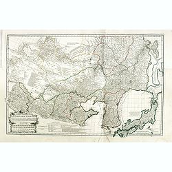
Nova Maris Caspii et Regions Usbeck..
A detailed map of part of Russia, Central Asia centered on the Caspian, Uzbek territory to the east of the Caspian and northern Persia. A finely engraved, uncolored title...
Date: Nuremberg, 1735
Selling price: ????
Please login to see price!
Sold in 2024
Nova Maris Caspii et Regions Usbeck..
A detailed map of Central Asia centered on the Caspian Uzbek territory to the east of the Caspian and northern Persia. A finely engraved, uncolored title piece showing co...
Date: Nuremberg, 1735
Selling price: ????
Please login to see price!
Sold in 2010
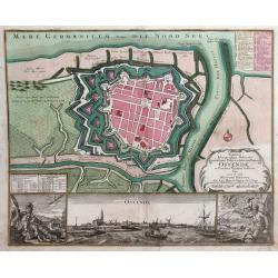
Novissima Ichnographica Delineatio munitissima Urbis et celeberrimi Emporii Ostenda, in Comitatu Flandria Austriaca fitae
Detailed city map of the city of Ostend, surrounded by walls and moats, on the coast of West Flanders, Belgium from Mathaus Seutter's Grosser Atlas. In the lower inset se...
Date: Augsburg, 1735
Selling price: ????
Please login to see price!
Sold in 2010
Plan de la Ville et Citadelle d'Anvers Renomee pour fon ports Comerce et edifices La citadelle est des plus fortes au monde, grave en taille douce
Detailed city map of the city of Anvers (now Antwerp), Belgium, surrounded by walls and moats, from Mathaus Seutter's Grosser Atlas. A view of the bustling port of Antwer...
Date: Augsburg, 1735
Selling price: ????
Please login to see price!
Sold in 2010
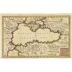
Nieuwe kaart van de Crim de Zwarte Zee en omleggende. . .
Showing the Black Sea and the Marmara Sea with Istanbul. Published in the rare first edition of Kleyne en Beknopte Atlas, of Tooneel des Oorlogs in Europa...The atlas wa...
Date: Amsterdam, 1735
Selling price: ????
Please login to see price!
Sold in 2013
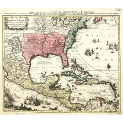
Mappa Geographica Regionem Mexicanam et Floridam.
It covers Central America with the Caribbean and the eastern part of the United States to the Great Lakes and New Mexico. In the lower-left is a beautiful picture of a na...
Date: Augsburg, 1735
Selling price: ????
Please login to see price!
Sold in 2013
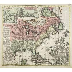
Accurata delineatio celeberrimae reg. Ludovicianae. . .
Includes the area from the Great Lakes to the Caribbean, in the center of the map the basin of the river Mississippi. In an inset part of Louisiana. With a very elaborate...
Date: Augsburg, 1735
Selling price: ????
Please login to see price!
Sold in 2010
![[10 Maps] Carte generale du Thibet ou Bout-Tan et des Pays de Kashgar et Hami Dress'ee sur les Cartes et Memoires des RR PP Jesuites de la Chine . . .](/uploads/cache/29978-250x250.jpg)
[10 Maps] Carte generale du Thibet ou Bout-Tan et des Pays de Kashgar et Hami Dress'ee sur les Cartes et Memoires des RR PP Jesuites de la Chine . . .
A general map of Tibet together with 9 regional maps. The first accurate cartographic depiction of Tibet that is available in the western world. Jean Baptiste Bourguignon...
Date: Paris, Le Mercier, 1735
Selling price: ????
Please login to see price!
Sold in 2012
![[11 Maps] . . . Feuille particuliere de la Tartarie Chinoise. . .](/uploads/cache/29979-250x250.jpg)
[11 Maps] . . . Feuille particuliere de la Tartarie Chinoise. . .
A group of 11 maps, together forming a large map of Tartary. The first accurate cartographic depiction of Tartary available in the western world. Jean Baptiste Bourguigno...
Date: Paris, Le Mercier, 1735
Selling price: ????
Please login to see price!
Sold in 2010
Potentissimo Borussorum Regi Friderico Wilhelmo...
Large 2-sheet map of an area of Lithuania and Eastern Prussia (Russian province of Kaliningrad) stretching from Klaipeda (Memel) in the north to Goldap in the south (a to...
Date: Nuremberg, 1735
Selling price: ????
Please login to see price!
Sold in 2011
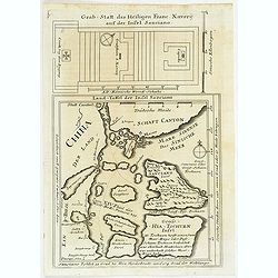
Land-Taffel der Insel Sanciano. Grab-Statt des Heiligen Franc. Xaverii auf der Insel Sanciano
A map (21,5:21 cm) of the southern coast of China with Macau, the Xiachuan Island and the Shangchuan Island, where Francis Xavier was buried. With the ground plan of Xavi...
Date: Augsburg, 1735
Selling price: ????
Please login to see price!
Sold in 2011

Wratislavia Antiquissima et Celeberrima Ducat. Silesiaci Metropolis ... / Breslau due Uhralte u Hochberuhmte Haupt Statt des Herzogth. Schleisien.
Large, old colored engraved town-plan of Wroclaw by Matthaus Seutter. The overall perspective plan with determination of individual buildings as well as detailed explanat...
Date: Augsburg, 1735
Selling price: ????
Please login to see price!
Sold
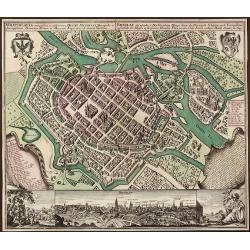
Wratislavia Antiquissima et Celeberrima Ducat. Silesiaci Metropolis ... / Breslau due Uhralte u Hochberuhmte Haupt Statt des Herzogth. Schleisien.
Large, old colored engraved town-plan of Wroclaw by Matthaus Seutter. The overall perspective plan with determination of individual buildings as well as detailed explanat...
Date: Augsburg, 1735
Selling price: ????
Please login to see price!
Sold in 2015
ICONOGRAPHIA FRIEDERICOPOLEOS.
An attractive town plan of Friedrickstadt in North West Germany with an attractive prospect of the town and cartouche from the atlas published by Weigel in Nuremberg.
Date: Nuremberg, 1735
Selling price: ????
Please login to see price!
Sold in 2012
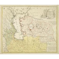
Fines Hungariae victoriis Caroli VI Caes. Aug. et pace Pasarovicensi ampliatos in hac tabula color flavus indicat.
A less common map of Hungary centered on Principatus Transillvaniae by Christoph Weigel highly detailed.
Date: Nuremberg,1735
Selling price: ????
Please login to see price!
Sold in 2012
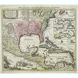
Mappa Geographica Regionem Mexicanam et Floridam.
Covers Central America with the Caribbean and the eastern part of the United States to the Great Lakes and New Mexico. In lower left a beautiful picture of a naval battle...
Date: Augsburg, 1735
Selling price: ????
Please login to see price!
Sold in 2012
Accurata delineatio celeberrimae reg. Ludovicianae. . .
Includes the area from the Great Lakes to the Caribbean, in the center of the map the basin of the river Mississippi. In an inset part of Louisiana. With a very elaborate...
Date: Augsburg, 1735
Selling price: ????
Please login to see price!
Sold
Accurata delineatio celeberrimae reg. Ludovicianae. . .
Includes the area from the Great Lakes to the Caribbean, in the center of the map the basin of the river Mississippi. In an inset part of Louisiana. With a very elaborate...
Date: Augsburg, 1735
Selling price: ????
Please login to see price!
Sold in 2012
Potentissimo Borussorum Regi Friderico Wilhelmo...
Large sought-after 2-sheet map of an area of Lithuania and Eastern Prussia (Russian province of Kaliningrad) stretching from Klaipeda (Memel) in the north to Goldap in th...
Date: Nuremberg, 1735
Selling price: ????
Please login to see price!
Sold in 2012
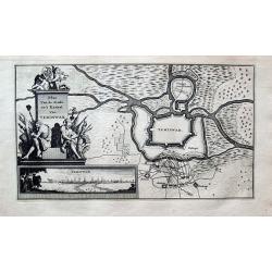
Plan Van de Stadt en't Kasteel Van TEMISWAR.
Unusual map of Temesvár or Timișoara. Shows the city fortifications being attacked. With a large decorative title with figures and weapons. Includes an inset vi...
Date: Amsterdam, 1735
Selling price: ????
Please login to see price!
Sold in 2020
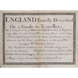
(Title page) England Exactly Described Or a Guide to Travellers.
Title Page from Bakewell's "English County Atlas".
Date: England, 1735
Selling price: ????
Please login to see price!
Sold in 2014
Potentissimo Borussorum Regi Friderico Wilhelmo. . .
Large sought-after 2-sheet map of an area of Lithuania and Eastern Prussia (Russian province of Kaliningrad) stretching from Klaipeda (Memel) in the north to Goldap in th...
Date: Nuremberg, 1735
Selling price: ????
Please login to see price!
Sold in 2015
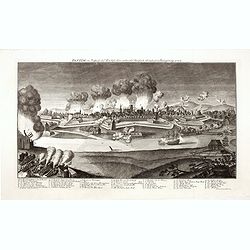
Danzig, im Prospect der Weichselseite unter der russisch-sächsischen Belagerung 1734.
Fine engraving of the Russian and Saksonian siege of Danzig in 1734. With a burning town and a numbered key (1-30) below.Engraved by Georg Paul Busch after Daniel Schultz...
Date: Cologne, H.P. Merian, 1735
Selling price: ????
Please login to see price!
Sold in 2014
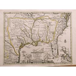
La Floride, suivant les Nouvelles Observations...
Fantastic map based on Delisle's important map of the southern United States of America, stretching from what is now Texas to Florida, and as far north as Tennessee and V...
Date: Amsterdam, 1735
Selling price: ????
Please login to see price!
Sold in 2014
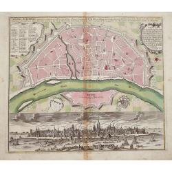
Colonia Agrippina Antiquisima, Maxima Ac Celeberrima Libera Imperii Civitas et Emporium Florentissimum.
Double-page engraved plan of Cologne showing all the churches and notable places, with a view of the city below looking from across the Rhine. with an inset decorative ca...
Date: Augsburg, 1735
Selling price: ????
Please login to see price!
Sold in 2017
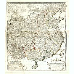
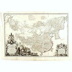
Carte Generale de la Chine Dressée sur les Cartes Particulieres Que l' Empereur Chang-Hi a fait lever sur les lieux..
Large map showing the traditional limits of China, including Hainan and Formosa in the South, and Quantong and parts of the Gobi Desert in the North.As the title notes, t...
Date: Paris , 1735
Selling price: ????
Please login to see price!
Sold in 2016
Carte Generale De La Tartarie Chinoise Dressee sur les Cartes Particulieres Faits Sur Les Lieux Par Les R.R. P.P. Jesuites . . . .MDCCXXXII
D'Anville is very important for Korean cartography as he made the cartography of Korea widely available. The map is the first fairly accurate western map of Korea, though...
Date: Paris, 1735
Selling price: ????
Please login to see price!
Sold in 2018
Carte la plus generale et qui comprend la Chine, la Tartarie chinoise et le Thibet. . .
With a quite elaborately pictorial cartouche, engraved by G.Kondet. Very detailed map of China, Tibet and Korea. Jean Baptiste Bourguignon d' Anville (1697-1782), French ...
Date: Paris, 1735
Selling price: ????
Please login to see price!
Sold
Ontzet van de Stad Nerva door zyne Koninglyke Majesteit van Sweden, voorgevallen op den 30sten November 1700.
An attractive etching showing a battle scene before the city of Nerva during the relief of the City by the King of Sweden on 30 November 1700.Engraved by Gasper Luyken.Fi...
Date: Amsterdam, 1735
Selling price: ????
Please login to see price!
Sold in 2014
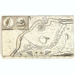
Beleg van Nerva door de Muskoviters.
An attractive engraving showing the battle plan of the city of Nerva during the siege by the Peter the Great. With two engraved medallions in left upper corner.First publ...
Date: Amsterdam, 1735
Selling price: ????
Please login to see price!
Sold in 2014
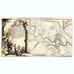
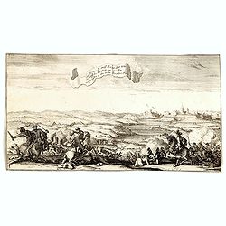
Afbeelding der Batallje tusschen de Moscoviters en de Turken aan de Rivier de Prut.
An attractive engraving showing the battle plan along the river Prut in Moldavie. Decorative lettered key A-R in left part.During the Russo-Turkish War of 1710–1711, on...
Date: Amsterdam, 1735
Selling price: ????
Please login to see price!
Sold in 2014
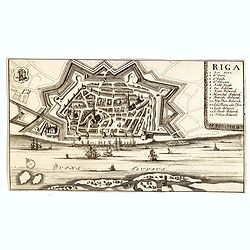
Beleg van Nerva door de Muskoviters.
An attractive engraving showing Riga, the capital of Latvia. In the foreground the River Daugava. Riga is the largest city in the Baltic states. First published by Erven ...
Date: Amsterdam, 1735
Selling price: ????
Please login to see price!
Sold in 2014
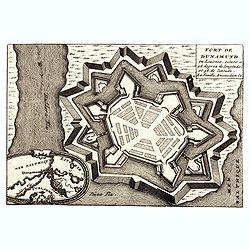
Fort de Dunamund en Livonie, située a 48 degrez de longitude. . .
An detailed engraving of a fortress of Daugavgriva (Dunamunde, Dynemunt) in Latvia with an inset map of Riga with its surroundings.First published by DeLa Feuille, than p...
Date: Amsterdam, 1735
Selling price: ????
Please login to see price!
Sold in 2014

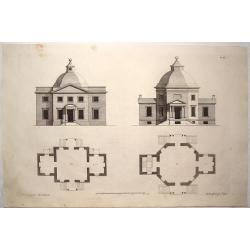
The East End & Section From South to North pl 11.
Fine architectural copper engraving of a domed building. It was engraved by T. Harris. James Gibbs (1682 – 1754) was one of Britain's most influential architects. Born ...
Date: London, c1735
Selling price: ????
Please login to see price!
Sold in 2017
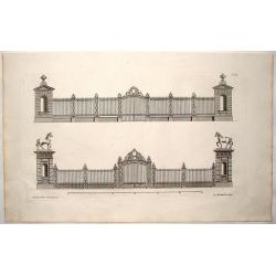
Architectural Iron Fence & Gate by Gibbs.
Fine architectural copper engraving of an iron fence and gar . It was engraved by E. Kirkall. James Gibbs (1682 – 1754) was one of Britain's most influential architect...
Date: London, c1735
Selling price: ????
Please login to see price!
Sold in 2019
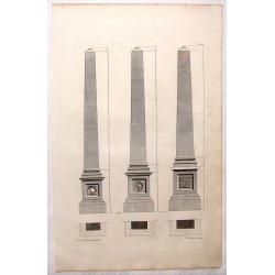
Three architectural Columns by Gibbs.
Fine architectural copper engraving of three pillars. It was engraved by E. Kirkall. James Gibbs (1682 – 1754) was one of Britain's most influential architects. Born i...
Date: London, c1735
Selling price: ????
Please login to see price!
Sold in 2015

Interesting Brick Building by Gibbs.
Fine architectural copper engraving of an interesting brick building. It was engraved by H. Hulsberg.James Gibbs (1682 – 1754) was one of Britain's most influential arc...
Date: London, c1735
Selling price: ????
Please login to see price!
Sold in 2019
Front & Back of a Domed building by Gibbs.
Fine architectural copper engraving of front & back of a domed building. It was engraved by H. Hulsbergh.James Gibbs (1682 – 1754) was one of Britain's most influen...
Date: London, c1735
Selling price: ????
Please login to see price!
Sold in 2017
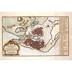
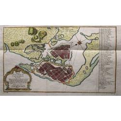
Plan de la Ville de Carthagene des Indes.
Nice map of the city of Cartegena and Magna Island in Columbia. It has a decorative title cartouche and the key places are identified in the index to the right.
Date: Paris, 1735
Selling price: ????
Please login to see price!
Sold in 2015
Novissima et accuratissima Magni Ducatus Lithuaniae in suos Palatinaus et Castellanias divisae Delineatio . . .
Uncommon third edition of Seutter's map of Lithuania, extending from Riga to Palatinat Polesia Bressicenis in the south.This is the third edition with the JM Probst impri...
Date: Augsburg, 1735
Selling price: ????
Please login to see price!
Sold in 2017
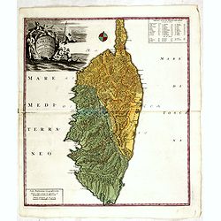
nsulae Corsicae Accurata Chorographia Tradita Per I. Vogt Capit. S. C. M. et excusa Studio Homannian. Heredum / Norib. MDCCXXXV
Extremely well-detailed map of Corsica, published 1735 by Homann Hires. Divided into 38 districts. At upper right with a decorative title cartouche with allegorical depic...
Date: Nuremberg, 1735
Selling price: ????
Please login to see price!
Sold
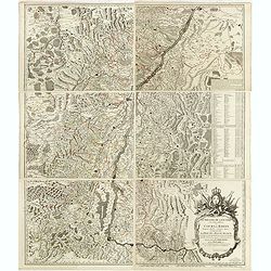
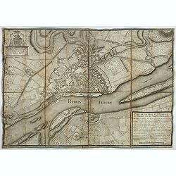
Le Theatre de la Guerre sur le Haut Rhein ou Cours du Rhein. . .
Very detailed six sheet map of Alsace centered on River Rhine.Gilles Robert de Vaugondy (1688–1766), also known as Le Sieur or Monsieur Robert, and his son, Didier Robe...
Date: Paris, 1735
Selling price: ????
Please login to see price!
Sold
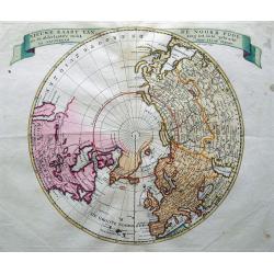
Nieuwe Kaart van de Noord Pool. . .
Interesting map with north polar projection. California is shown as an Island, and unfinished coast lines of the North-West. Shows New Denmark, Greenland, Compagnie Land,...
Date: Amsterdam, 1735
Selling price: ????
Please login to see price!
Sold in 2015
Plan de la Ville de Carthagene des Indes.
Striking and highly detailed Bellin's copper engraved areal plan of Cartagena and Cartagena Bay, mapped by Antonio de Ulloa en 1735.The full color map presents a key list...
Date: Paris, 1735
Selling price: ????
Please login to see price!
Sold in 2015
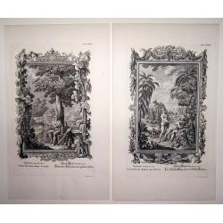
Garden of Eden and Expulsion from Paradise.
A set of 4 copper engravings; overall size 41 x 24 cm each . from Scheuchzer's 'Kupfer-Bibel, in welcher die Physica Sacra, oder geheiligte Natur-Wissenschafft derer in H...
Date: Augsburg/Ulm, 1731-1735
Selling price: ????
Please login to see price!
Sold in 2015
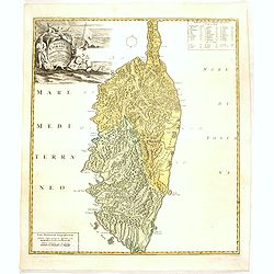
Insulae Corsicae Accurata Chorographia Tradita Per I. Vogt Capit. S. C. M. et excusa Studio Homannian. Heredum / Norib. MDCCXXXV
Extremely well-detailed map of Corsica, published 1735 by Homann Hires. Divided into 38 districts. At upper right with a decorative title cartouche with allegorical depic...
Date: Nuremberg, 1735
Selling price: ????
Please login to see price!
Sold in 2016
Potentissimo Borussorum Regi Friderico Wilhelmo Maiestate, Fortitudine Clementia Augustissimo Hancce Lithuaniam Borussicam : in qua luca coloniis Salisburg., ad incolendum Regio nutu concessa chorographice exhibentur D. D. D. Regiae Suae Maiestatis.
Large 2-sheet map of an area of Lithuania and Eastern Prussia (Russian province of Kaliningrad) stretching from Klaipeda (Memel) in the north to Goldap in the south (a to...
Date: Nuremberg, 1735
Selling price: ????
Please login to see price!
Sold in 2016
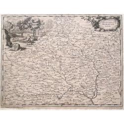
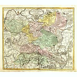
Marchionatus Moraviae Tabula.
Scarce map of Moravia, Czech Republic. Includes numerous towns, including the cities of Jihlava, Brno, Olomouc, and Uherské Hradiště. Extends to the borders of...
Date: Augsburg, ca. 1735
Selling price: ????
Please login to see price!
Sold in 2016
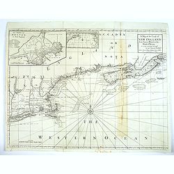
A Map of the Coast of New England from Staten Island to the island of Breton. . .
From the first marine atlas produced in the colonies was drawn by Captain Cyprian Southack (1662-1745). He is of great importance in North American cartography Of the fir...
Date: London, ca. 1735
Selling price: ????
Please login to see price!
Sold in 2017
![Province de Quang-Si. [Quang-si 广西 [Guangxi] province]](/uploads/cache/39686-250x250.jpg)
Province de Quang-Si. [Quang-si 广西 [Guangxi] province]
Important map of Quang-si 广西 [Guangxi] province. With a quite elaborately pictorial cartouche featuring a rococo chinoiserie ornamentation, engraved...
Date: Paris, P.G. Le Mercier, 1735
Selling price: ????
Please login to see price!
Sold in 2020
![Province d'Yun-Nan. [Yun-nan 云南 [Yunnan] province.]](/uploads/cache/39687-250x250.jpg)
Province d'Yun-Nan. [Yun-nan 云南 [Yunnan] province.]
Important map of Yun-nan 云南 [Yunnan] province. With a quite elaborately pictorial cartouche featuring a rococo chinoiserie ornamentation, engraved b...
Date: Paris, P.G. Le Mercier, 1735
Selling price: ????
Please login to see price!
Sold
![Province de Kiang-Nan. [Kiang-nan 江南 [Jiangnan] province.]](/uploads/cache/39690-250x250.jpg)
Province de Kiang-Nan. [Kiang-nan 江南 [Jiangnan] province.]
Important map of Kiang-nan 江南 [Jiangnan] province. With a quite elaborately pictorial cartouche featuring a rococo chinoiserie ornamentation, engrav...
Date: Paris, P.G. Le Mercier, 1735
Selling price: ????
Please login to see price!
Sold in 2017
![Province de Chen-Si. [Chen-si 陕西 [Shaanxi] province.]](/uploads/cache/39698-250x250.jpg)
Province de Chen-Si. [Chen-si 陕西 [Shaanxi] province.]
Important map of Chen-si 陕西 [Shaanxi] province. With a quite elaborately pictorial cartouche, engraved by Guélard, the map by Delahaye, featuring a...
Date: Paris, P.G. Le Mercier, 1735
Selling price: ????
Please login to see price!
Sold in 2017
Plan de la ville et citadelle de Mayence, avec ses nouvelles fortifications. . .
Beautiful plan of the city of Mainz, dedicated to the cardinal of Fleury, and adorned with his coat of arms. In bottom right a description of Mainz and a lettered key (A ...
Date: Paris, 1735
Selling price: ????
Please login to see price!
Sold in 2019
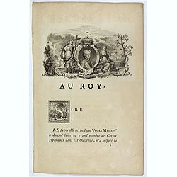
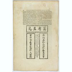
Dedication page to the King of France.
Text page showing an engraving (130x210mm.) of the young King followed by a letter addressed to him. Jean Baptiste Bourguignon d' Anville (1697-1782), French cartographer...
Date: Paris, P.G. Le Mercier, 1735
Selling price: ????
Please login to see price!
Sold in 2018
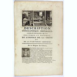
Description geographique, historique, chronologique, politique et physique de l'Empire de chine et de la Tartarie / De la Religion des Chinois.
Text page with a copper engraving (90x175mm.) showing an interior with Chinese persons. Jean Baptiste Bourguignon d' Anville (1697-1782), French cartographer. Compiled ov...
Date: Paris, P.G. Le Mercier, 1735
Selling price: ????
Please login to see price!
Sold in 2018
Au vrai principe de toutes choses.
Text page with an engraving. Jean Baptiste Bourguignon d' Anville (1697-1782), French cartographer. Compiled over 200 maps. This map is from his most important work Nou...
Date: Paris, P.G. Le Mercier, 1735
Selling price: ????
Please login to see price!
Sold in 2017
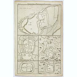
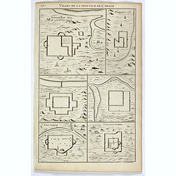
Villes de la province de Tche-kiang. (Hang-tcheou-fou, Ping hou hien, Hou-tcheou-fou, Hia-hing-fou and Ku-tcheou-fou.)
Five towns plans : Hang-tcheou-fou, Ping hou hien, Hou-tcheou-fou, Hia-hing-fou and Ku-tcheou-fou.From "Description geographique, historique, chronologique, politiqu...
Date: Paris, P.G. Le Mercier, 1735
Selling price: ????
Please login to see price!
Sold in 2022
Villes de la province de Kiang-nan.
Eight town plans : Nan-king, Sou-tcheou-fou, Koen-chan-hien, Tsi-ki-hien, Vou-si-hien, Kia-ting-hien, Tchan-chou-hien and Tsing-pou-hien.From "Description geographiq...
Date: Paris, P.G. Le Mercier, 1735
Selling price: ????
Please login to see price!
Sold in 2022
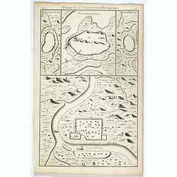
Villes de la province de Hou-Quang.
4 town plans : Yong-tcheou-fou, Vou-tchang-fou, Hoang tcheou fou and Siang-yang-fou. From "Description geographique, historique, chronologique, politique, et physiqu...
Date: Paris, P.G. Le Mercier, 1735
Selling price: ????
Please login to see price!
Sold in 2022
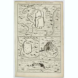
Villes de la province de Chensi.
Six town plans : Si-ngan-fou, capitale…, Tchouang-lan, Lan-tcheou, Can-tcheou, King-tcheou and Cou-yuen-tcheou. From "Description geographique, historique, chronol...
Date: Paris, P.G. Le Mercier, 1735
Selling price: ????
Please login to see price!
Sold in 2017
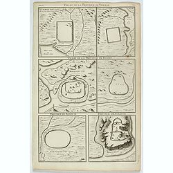
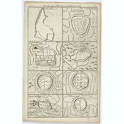
Villes de la province de Yun-nan. VI.
Six town plans : Yun-nan-Fou, Ta-Li-Fou, Kien-Ning-Fou, Tchang-Tai-Hien, Nan-Tchang-Fou ad Kia-Tcheou.From "Description geographique, historique, chronologique, poli...
Date: Paris, P.G. Le Mercier, 1735
Selling price: ????
Please login to see price!
Sold in 2022
Villes de la province de Koei-tcheou. VII
Four town plans : Koei-yang-fou, Ping-yuen-fou, Pou-ngan-tcheou and Tchin-yuen-fou. From "Description geographique, historique, chronologique, politique, et physique...
Date: Paris, P.G. Le Mercier, 1735
Selling price: ????
Please login to see price!
Sold in 2022
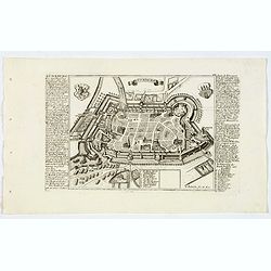
Luneburg.
A lovely example of Bodenehr's town plan of the northern German, Hanseatic city of Luneburg. A superb, decorative plan showing how this important city was laid out in the...
Date: Augsburg, ca 1735
Selling price: ????
Please login to see price!
Sold in 2020
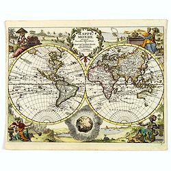
Mappe Monde suivant les Nouvelles Observations. . .
A very decorated World map, using the plate of Pieter Van der Aa from the beginning of the 18th century, by Covens & Mortier, published in the ´Atlas Covens´, Nouve...
Date: Amsterdam, ca 1735
Selling price: ????
Please login to see price!
Sold in 2019
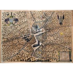
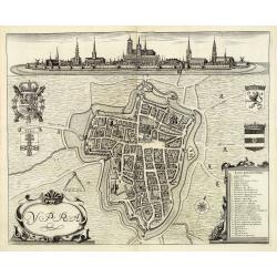
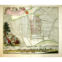
Steenvoorde.
An unusual birds-eye view of Steenvoorde, a commune in the Nord department in northern France. Engraved by Reynier Blokhuysen. Highly detailed with buildings, streets, pe...
Date: The Hague, Jan van der Deyster, 1735
Selling price: ????
Please login to see price!
Sold in 2020
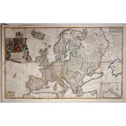
To His Royal Highness Frederick Lewis, Prince of Wales and Earl of Chester, Electoral Prince of Brunswick, This Map of Europe ...
This highly decorative large-format map of Europe was after the map originally published by John Senex in London in 1708. However, this special edition was published b...
Date: Dublin, ca. 1735
Selling price: ????
Please login to see price!
Sold in 2020
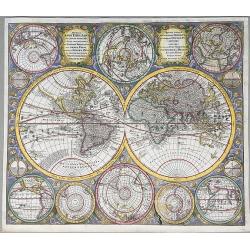
Diversi Globi Terr-Aquei Statione variante (...)
A large-sized 18th-century world map with several (8) Globi Terr-Aquei and border decorations. From: Matthias Seutter, ‘Atlas Novus sive Tabulae Geographicae totius or...
Date: Augsburg, ca. 1735
Selling price: ????
Please login to see price!
Sold in 2023
![[Snakes and Birds.]](/uploads/cache/84082-250x250.jpg)
[Snakes and Birds.]
Print from Albertus Seba's 'Thesaurus', showing snakes and birds. Albertus Seba (1665-1736) was a Dutch apothecary, zoölogist, author, collector and owner of a 'Cabinet ...
Date: Amsterdam, 1735
Selling price: ????
Please login to see price!
Sold in 2020
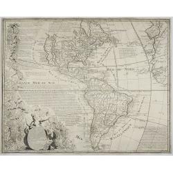
Amerique.
A rare map of the western hemisphere, including portraits of explorers, such as Jacques Marquette, Louis Joliet, and Robert Cavelier de La Salle. Coats of arms present in...
Date: Paris, 1735
Selling price: ????
Please login to see price!
Sold in 2020
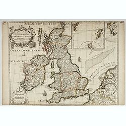
Les Isles Britanniques Comprenant les Royaumes d'Angleterre, Ecosse, et D'Irlande... Dressé sur les Observations Nouvelles par Crepy Geographe.
Separate publication. "Crepy's map shows the British Isles, with a large insert panel of the Shetland and Faeroe Islands. The two elegant cartouches-one containing t...
Date: Paris , ca. 1735
Selling price: ????
Please login to see price!
Sold in 2022
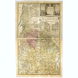
Kiel - Die Herzogl. Holstein Gottorp: Residenz_See_und Handelstadt Kiel
This Homann map depicts the major maritime city of Kiel, the capital of the German state of Schleswig-Holstein, located on an fjord of the southwestern shore of the Balti...
Date: Nuremberg, 1735
Selling price: ????
Please login to see price!
Sold in 2023
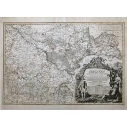
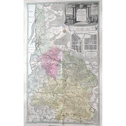
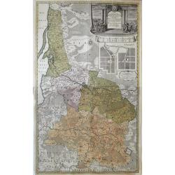
PRINCIPATUS SILESIAE BREGENSIS exactissima Tabula Geographica exhibens Circulos BRIEG, OHLAU, STREHLEN, NIMBTSCH, CREUTZBURG et PITSCHEN. . .
Map done during the reign of Karl VI (1711–1740), and a detailed survey of Silesia that was undertaken by the engineer Lieutenant Johann Wolfgang Wieland, which was com...
Date: Nuremberg, 1736
Selling price: ????
Please login to see price!
Sold in 2020

The Empire of China and Island of Japan. . .
The map is of interest for the use of East Sea, the sea between Korea and Japan, here called "Sea of Corea". Some interesting notations are made. From his atlas...
Date: London, 1736
Selling price: ????
Please login to see price!
Sold in 2024