Browse Listings
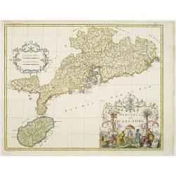
Province de Quang-Tong.
With a quite elaborately pictorial cartouche, engraved by D.Sornique. Very detailed map of Hong Kong and its surroundings. Jean Baptiste Bourguignon d' Anville (1697-1782...
Date: The Hague, 1737
Selling price: ????
Please login to see price!
Sold in 2011
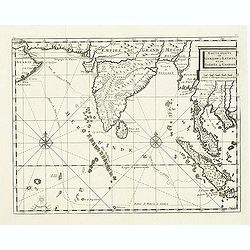
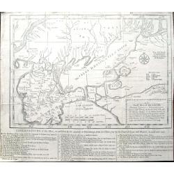
Route Exacte de Gamron a Batavia et De Batavia a Gamron
The map depicts his route from Gamron (modern Bandar Abas) to Batavia (Jakarta). Finely engraved with a decorative title cartouche and compass rose.Taken from "Trave...
Date: Amsterdam, 1737
Selling price: ????
Please login to see price!
Sold in 2011
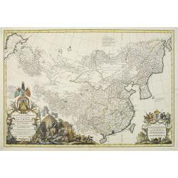
Carte la plus generale et qui comprend la Chine, la Tartarie chinoise et le Thibet. . .
With a quite elaborately pictorial cartouche, engraved by G.Kondet. Very detailed map of China, Tibet and Korea. Jean Baptiste Bourguignon d' Anville (1697-1782), French ...
Date: Paris, 1737
Selling price: ????
Please login to see price!
Sold
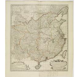
Carte Generale de la Chine Dressée sur les Cartes Particulieres Que l' Empereur Chang-Hi a fait lever sur les lieux..
Large map showing the traditional limits of China, including Hainan and Formosa in the South, and Quantong and parts of the Gobi Desert in the North.As the title notes, t...
Date: Paris , 1737
Selling price: ????
Please login to see price!
Sold in 2014
![Afbeelding der vesting Tionningen.. [Two prints]](/uploads/cache/12575-250x250.jpg)
Afbeelding der vesting Tionningen.. [Two prints]
Attractive map and a panoramic view of the siege of Tonnigen, published in "Kleyne en Beknopte Atlas, of Tooneel des Oorlogs in Europa..".The atlas was publishe...
Date: Amsterdam 1738
Selling price: ????
Please login to see price!
Sold
Carte du Canada Dediée a Son Altesse. . .
Uncommon map of America's east coast, including the Great Lakes and north eastern part of Canada. From: Le Beau, Avantures du Sr. C.Le Beau.More about Mapping of Canada [...
Date: Amsterdam, 1738
Selling price: ????
Please login to see price!
Sold in 2020
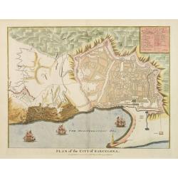
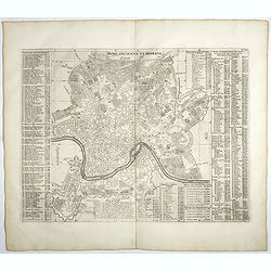
Plan of the City of Barcelona
From Rapin's History of England , a nicely detailed plan of Barcelona, the capital of Catalonia. The plate contains a 19 point legend and the presentation is enhanced wit...
Date: London c.1738
Selling price: ????
Please login to see price!
Sold
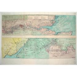
THE EAST PART OF THE RIVER THAMES / THE WEST PART OF THE RIVER THAMES
An attractive and detailed map of the River Thames. The top portion of the work focuses on the eastern end of the river, highlighting London and directly west. The lower ...
Date: London, ca. 1738
Selling price: ????
Please login to see price!
Sold
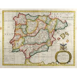
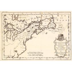
A New Map of Present Spain & Portugal
Decorative colored map of Spain and Portugal with parts of France, the northern part of Africa and the Balearic Islands. From "A New Sett of Maps both of Antient an...
Date: London, 1738
Selling price: ????
Please login to see price!
Sold in 2012
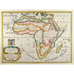
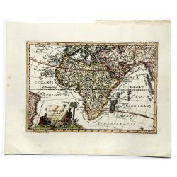
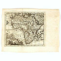
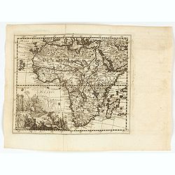
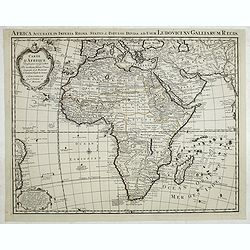
A New Map of Africk Shewing its Present General Divisions Cheif Cities or Towns, Rivers, Mountains &c.
Decorative colored map of the African continent. From "A New Sett of Maps both of Antient and Present Geography" by Edward Wells an English clergyman, teacher ...
Date: London, 1738
Selling price: ????
Please login to see price!
Sold in 2012
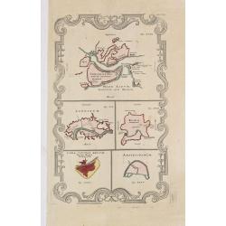
A New Map of The Western Parts of Asia Minor
Decorative colored map of Asia Minor with several Greek Island and the Western part of Turkey and the Bosporus. From "A New Sett of Maps both of Antient and Present...
Date: London, 1738
Selling price: ????
Please login to see price!
Sold in 2013
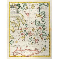
A New Map of the Islands of the Aegaean Sea, together with the Island of Crete, and the Adjoining Isles
Decorative colored map of the Aegean Sea with Crete and the western part of Turkey. From "A New Sett of Maps both of Antient and Present Geography" by Edward W...
Date: London, 1738
Selling price: ????
Please login to see price!
Sold in 2009
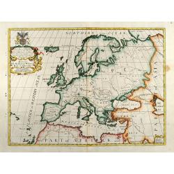
A New Map of Europe according to the Present General Divisions and Names
Decorative colored map of the European continent. From "A New Sett of Maps both of Antient and Present Geography" by Edward Wells an English clergyman, teacher...
Date: London, 1738
Selling price: ????
Please login to see price!
Sold in 2009
A New Map of Turky in Europe, And Parts of adjoyning
Decorative colored map of Greece, the Balkans and the Western part of Turkey. From "A New Sett of Maps both of Antient and Present Geography" by Edward Wells a...
Date: London, 1738
Selling price: ????
Please login to see price!
Sold in 2009
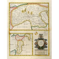
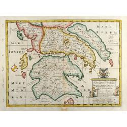
A New Map of Gallia Cisalpina & Graecia Magna
Decorative colored map of Northern Italy in the upper part and beneath this South Italy with parts of Sicily. With a beautiful unusual cartouche. From "A New Sett of...
Date: London, 1738
Selling price: ????
Please login to see price!
Sold in 2013
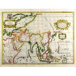
A New Map of Present Asia
Decorative colored map of the Asian continent. From "A New Sett of Maps both of Antient and Present Geography" by Edward Wells an English clergyman, teacher an...
Date: London, 1738
Selling price: ????
Please login to see price!
Sold in 2009
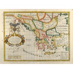
A New Map of the So. & Mid Parts of Antient Greece viz. Epirus, Hellas, or Graecia Propria, and Peloponnesus, together with Adjoyning Islands
Decorative colored map of the Peloponnese (Morea) in Greece. From "A New Sett of Maps both of Antient and Present Geography" by Edward Wells an English clergym...
Date: London, 1738
Selling price: ????
Please login to see price!
Sold in 2010
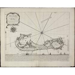
To his Excellency Alured Popple Esq. Governour of Bermuda, or the Summer Islands. This Map.
Important and exceptional rare sea chart of the Bermuda IslandsClement Lempriere's chart of Bermuda, published in 1738, was the next major advance after Arent Roggeveen c...
Date: London, 1738
Selling price: ????
Please login to see price!
Sold in 2010
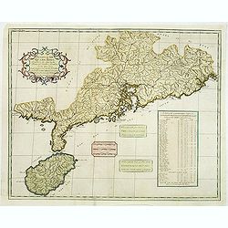
Province XII. Quang-tong. . .
From the rare English text edition of Du Halde's description of China. Showing the area around present-day Hong Kong in good detail. Map of Quang-Tong (Guangdong) showing...
Date: London, 1738
Selling price: ????
Please login to see price!
Sold in 2013
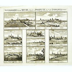
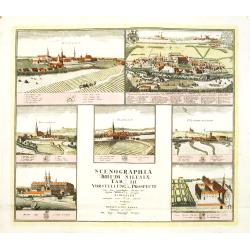
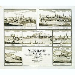
Scenographia Urbium Silesiae, Tab I. / Prospect der Stadte Schlesiens I. Tabell. . . Oels und Brieg. . .
Eight panoramic town-views of Oels and Brieg on one sheet. After a design by the Prussian artist Friedrich Bernhard Werner (1690-1778) and published by Homann's heirs. Un...
Date: Nuremberg, c. 1738
Selling price: ????
Please login to see price!
Sold in 2012
Scenographia Urbium Silesiae, Tab III. / Prospect der Stadte Schlesiens III. Tabell. . . Fürstenth Wohlau. . .
Seven panoramic town-views of Wohlau on one sheet. After a design by the Prussian artist Friedrich Bernhard Werner (1690-1778) and published by Homann's heirs. Underneath...
Date: Nuremberg, c. 1738
Selling price: ????
Please login to see price!
Sold in 2012
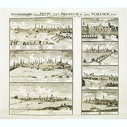
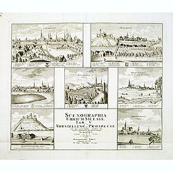
Scenographia Urbium Silesiae, Tab II. / Prospect der Stadte Schlesiens II. Tabell. . . Breslaw und Sagan. . .
Seven panoramic town-views of Breslau and Sagan on one sheet. After a design by the Prussian artist Friedrich Bernhard Werner (1690-1778) and published by Homann's heirs....
Date: Nuremberg, c. 1738
Selling price: ????
Please login to see price!
Sold in 2012
Scenographia Urbium Silesiae, Tab IV. / Prospect der Stadte Schlesiens Vierte Tabell. . . Neise. . .
Eight panoramic town-views of Neise on one sheet. After a design by the Prussian artist Friedrich Bernhard Werner (1690-1778) and published by Homann's heirs. Underneath ...
Date: Nuremberg, c. 1738
Selling price: ????
Please login to see price!
Sold in 2012
Scenographia Urbium Silesiae, Tab V. / Vorstellung der Prospecte . . . Liegnitz und Teschen . . .
Seven panoramic town-views of Liegnitz and Teschen on one sheet. After a design by the Prussian artist Friedrich Bernhard Werner (1690-1778) and published by Homann's hei...
Date: Nuremberg, c. 1738
Selling price: ????
Please login to see price!
Sold in 2012
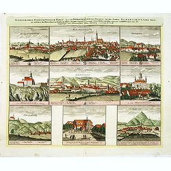
Scenographia Urbium Silesiae, Tab IV. / Prospect der Stadte Schlesiens Sechste Tabell. . . Schweidnitz. . .
Eight panoramic town-views of Schweidnitz on one sheet. After a design by the Prussian artist Friedrich Bernhard Werner (1690-1778) and published by Homann's heirs. Under...
Date: Nuremberg, c. 1738
Selling price: ????
Please login to see price!
Sold in 2012
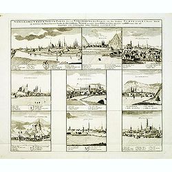
Scenographia Urbium Silesiae, Tab VII. / Vorstellung der Prospecte . . . Munsterb Jaegerend . . .
Seven panoramic town-views of Liegnitz and Munsterb Jaegerend on one sheet. After a design by the Prussian artist Friedrich Bernhard Werner (1690-1778) and published by H...
Date: Nuremberg, c. 1738
Selling price: ????
Please login to see price!
Sold in 2012
![Scenographia Urbium Silesiae, Tab [V] II. / Vorstellung der Prospecte . . . Munsterb Jaegerend . . .](/uploads/cache/33747-250x250.jpg)
Scenographia Urbium Silesiae, Tab [V] II. / Vorstellung der Prospecte . . . Munsterb Jaegerend . . .
Seven panoramic town-views of Liegnitz and Munsterb Jaegerend on one sheet. After a design by the Prussian artist Friedrich Bernhard Werner (1690-1778) and published by H...
Date: Nuremberg, after 1738
Selling price: ????
Please login to see price!
Sold in 2014
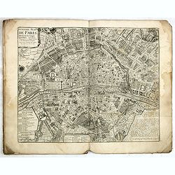
Traité de la Police. (8 plans of Paris).
Set of eight city plans of Paris, each map showing Paris from the time of Julius Caesar to Paris in 1705. The plate volume of Nicolas Delamare’s "La Traité de la ...
Date: Paris, 1705-1738
Selling price: ????
Please login to see price!
Sold

Strolling Actresses Dressing in a Barn.
Very fine impression of the first published state. Hogarth's theatrical satire, showing a company of touring players dressing and rehearsing their parts in ‘Devil to Pa...
Date: London, 1738
Selling price: ????
Please login to see price!
Sold in 2015
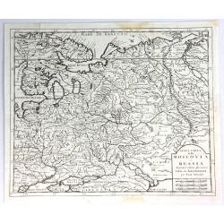
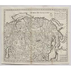
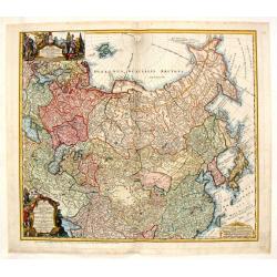
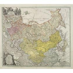
Nuova Carta della Moscovia o Russia.
A finely engraved map of European Russia with details of cities, towns, forests and topography, by Albrizzi, after Isaak Tirion (1705–1765) who was an 18th-century publ...
Date: Venice, 1738
Selling price: ????
Please login to see price!
Sold in 2018
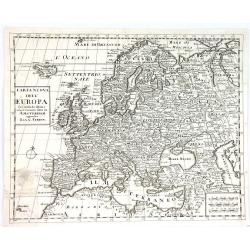
Carta Nuova Dell' Europa....
Map taken from "Atlas Novissimo" published by Giambattista Albrizzi in 1738. Later included in the "History of all peoples of the world" published in ...
Date: Venice, 1738
Selling price: ????
Please login to see price!
Sold in 2016
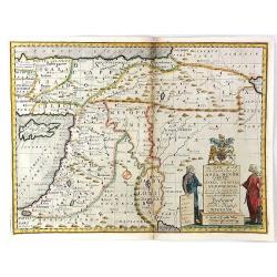
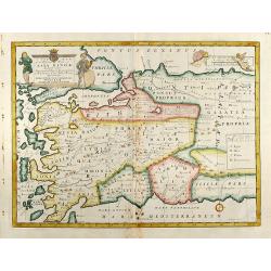
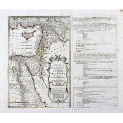
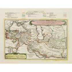
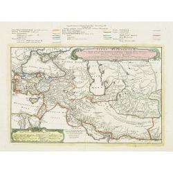
A New Map of the Eastern Parts of Asia Minor. Largely taken: As also of Syria, Armenia, Mesopotamia & c.
An interesting map of the Ottoman region from Eastern Turkey to the western shore of the Caspian Sea, and south to the Arabian Desert and Persian Gulf. Includes the moder...
Date: London, 1738
Selling price: ????
Please login to see price!
Sold in 2016
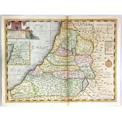
A New Map of the Land of Canaan
A decorative colored map of the Holy Land, divided among the twelve tribes of Israel.An inset of the Kingdom of Zobah is included in the top left corner. Engraved by Sutt...
Date: London, 1738
Selling price: ????
Please login to see price!
Sold in 2016
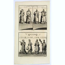
Mandarins, or place-men from du Halde/ Females from du Halde.
Two copperplate engravings on one plate from Duhalde's 'A description of the Empire of China and Chinese Tartary, together with the Kingdoms of Korea & Tibet. The fir...
Date: London, ca. 1738
Selling price: ????
Please login to see price!
Sold in 2019
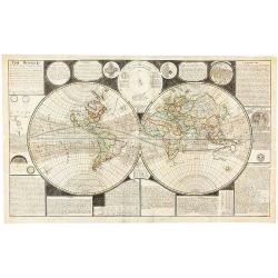
The World: A New and Correct Map laid down & described according to the latest discoveries. . .
'The World: A New and Correct Map laid down & described according to the latest discoveries, to which is added and Explanation of all these Lines (as the Equator, Ecl...
Date: London, 1738
Selling price: ????
Please login to see price!
Sold in 2019
AFRICAE emenduta Descriptio.
Map of Africa. With a cartouche on the down left corner. Engraved by Gottfried Haupt. Published in "Der Seinen zu erziehen habenden Jungen Cavalier in der Profan- un...
Date: Augsburg, 1738
Selling price: ????
Please login to see price!
Sold in 2019
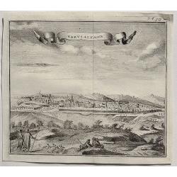
Gervsalemme.
A fine copper engraved bird’s eye view of Jerusalem by Salmon in 1738. It features a decorative ribbon cartouche. Thomas Salmon (1679–1767) was an English historical ...
Date: London, 1738
Selling price: ????
Please login to see price!
Sold in 2020
Accurata Repraesentatio ichnographica Urbis Episcopalis in Ducatu Lotharingiae, dictae Metae, antiquis Divodorum Mediomatricorum . . .
Map of Metz after a design of W. Zollmann.
Date: Nuremberg, 1738
Selling price: ????
Please login to see price!
Sold in 2021
Nuova Carta della Tartaria.
A detailed map of Tartaria, extending from the Caspian Sea to Japan, Korea, Kamtchatka and the Pacific by Tirion in 1738.Isaak Tirion (1705–1765) was an 18th-century pu...
Date: Amsterdam, 1738
Selling price: ????
Please login to see price!
Sold in 2020
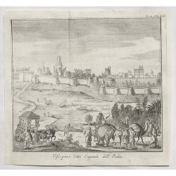
Visiapour Citta Capitale dell India.
A fine copper engraved city view of Visapur, in India by Salmon, issued in 1738.
Date: London, 1738
Selling price: ????
Please login to see price!
Sold in 2020
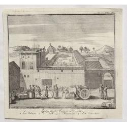
Luogo degli Inglesi a Suratte.
A fine copper engraved city view of La Chiesa, in India by Thomas Salmon in 1738.
Date: London, 1738
Selling price: ????
Please login to see price!
Sold in 2020
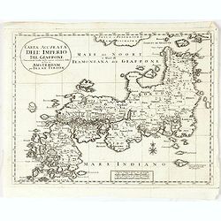
Carta Accurata dell' Imperio del Giappone. . .
Albrizzi published this Italian version of Tirion's first map of Japan. In the upper part of the map Jesso of Jesogasima Kamtzchatka is shown north of the Noto Peninsula....
Date: Venice, 1738
Selling price: ????
Please login to see price!
Sold in 2021
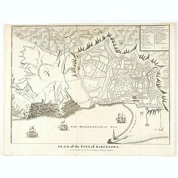
Plan of the City of Barcelona.
From Rapin's History of England , a nicely detailed plan of Barcelona, the capital of Catalonia. The plate contains a 19 point legend and the presentation is enhanced wit...
Date: London, c.1738
Selling price: ????
Please login to see price!
Sold in 2020
![[Lot of 2 items] Isoletta Desima Abittata Dagli Olandesi Nel Giappone / Plan du port et de la ville de Nangasaki.](/uploads/cache/84919-250x250.jpg)
[Lot of 2 items] Isoletta Desima Abittata Dagli Olandesi Nel Giappone / Plan du port et de la ville de Nangasaki.
A rare view of the island Deshima with a numbered index table below image. From the Italian translation of T. SALMON, 'Hedendaegsche historie of tegenwoordige staet van a...
Date: Venice, ca 1738
Selling price: ????
Please login to see price!
Sold in 2021
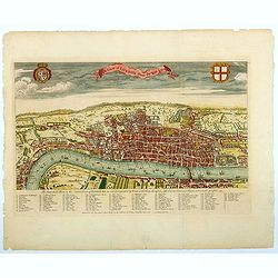
A View of London about the Year 1560.
Published as the frontispiece to Maitland's well recognized HISTORY OF LONDON, this is a sought after, handsome and finely engraved bird's-eye view / plan of Elizabethan ...
Date: London, ca 1738
Selling price: ????
Please login to see price!
Sold in 2021
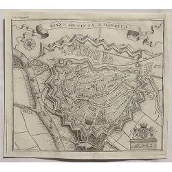
Piano della Citta di Danzica._
A fine copper engraved bird’s eye view shows Gdansk in Poland. From T. Salmon's "Lo stato presente di tutti i paesi e popoli del mondo ...". Published in Ven...
Date: Venice, 1739
Selling price: ????
Please login to see price!
Sold in 2020
Regni Davidici et Salomonaei descriptio Geographica cum vicinis regionibus Syriae et Aegypti. . .
A rare map of the Near East region, extending from Turkey to Egypt. It includes Cyprus, Holy Land, and Mesopotamia, and illustrates the Kingdoms of David and Solomon. Myt...
Date: Nuremberg, ca 1739
Selling price: ????
Please login to see price!
Sold in 2020
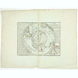
Carte des Terres Australes.
Important map of the South Pole. Shows Australia, Tasmania and New Zealand according to Tasman. No land at the pole. The map is a hemisphere within a rectangular frame.
Date: Paris, 1739
Selling price: ????
Please login to see price!
Sold in 2020
Les Isles Philippines Moluques et de la Sonde.
A very nice map of Southeast Asia with the Philippines including Borneo, Java, Sumatra and the Moluccas, with an inset map of Japan. From Francisco Giustiniani for El Atl...
Date: Leon de Francia (Lyon), Jaime Certa, 1739
Selling price: ????
Please login to see price!
Sold in 2021
Africae.
A very nice map of the African continent with an adorned title cartouche. From Francisco Giustiniani for El Atlas abreviado o el nuevo compendio de la Geografia universal...
Date: Leon de Francia (Lyon), Jaime Certa, 1739
Selling price: ????
Please login to see price!
Sold in 2021
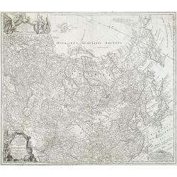
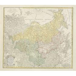
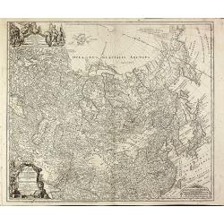
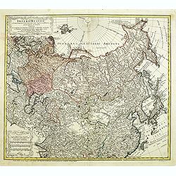
Imperii Russici et Tatariae Universae.
Finely engraved map of Greater Russia, from the Baltic, across Siberia to Kamchatka, with Japan, Korea, and the Greater portion of China. Very elaborate cartouche with be...
Date: Nuremberg, 1739
Selling price: ????
Please login to see price!
Sold in 2013
Imperii Russici et Tartariae Universae tam majoris Afiaticæ quam minoris et EuropæTabula.
Decorative map covering Russia, Tibet, China, Tartary, Korea, Taiwan and Japan prepared by J. M. Hasius. With a hefty landmass north of Honshu touching the Asian continen...
Date: Nuremberg, 1739
Selling price: ????
Please login to see price!
Sold in 2013

Title page: Atlas Historique..
Title page, engraved by Sluyter, after a design of Romeyn de Hooghe. Filled with allegorical figures. With the address : "Chez les Freres Chatelain à Amsterdam"...
Date: Amsterdam, 1705-1739
Selling price: ????
Please login to see price!
Sold
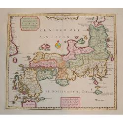
"Naauw-Keurige Kaart van 't Keizerryk Japan."
A stunning map of Japan based on the Kaempfer / Scheur type. The map is corrected from his previous work on Japan as it incorporates more accurate geography for the north...
Date: Amsterdam 1739
Selling price: ????
Please login to see price!
Sold
Typus Aetiologicus II.
Map covering the Middle East from the Eastern Mediterranean to the borders of India. Outline coloring shows the political division of the region under Seleucos I.
Date: Nuremberg 1739
Selling price: ????
Please login to see price!
Sold in 2008
Five plans on one sheet: Istanbul, London, Rome, Lima, Amsterdam.
A rare composite sheet of engravings of town-plans of Istanbul, London, Rome, Lima, Amsterdam From : "Regni Davidici et Salomon Descriptio Geographica et Historica, ...
Date: Nuremberg, Homann, 1739
Selling price: ????
Please login to see price!
Sold in 2021
Tartariae Maioris sive Asiaticae Tabula..
This antique map shows the "Russian Tartary" and as well the "Asian Tartary".With title cartouche in the lower left corner, another title cartouche wi...
Date: Nuremberg, 1739
Selling price: ????
Please login to see price!
Sold
Imperii Russici et Tartariae Universae tam majoris Afiaticæ quam minoris et EuropæTabula.
Decorative map covering Russia, Tibet, China, Tartary, Korea, Taiwan and Japan prepared by J. M. Hasius. With a hefty landmass north of Honshu touching the Asian continen...
Date: Nuremberg, 1739
Selling price: ????
Please login to see price!
Sold in 2009
![[Title page] Atlas Historique Tome. II.](/uploads/cache/27211-250x250.jpg)
[Title page] Atlas Historique Tome. II.
Allegorical title-page. From L'Honore & Chatelain's most remarkable atlas, published in seven volumes in various editions from 1705 to 1739.Volume 2.Engraved by Sluyt...
Date: Amsterdam, 1705-1739
Selling price: ????
Please login to see price!
Sold in 2020
Typus Aetiologicus II.
Rare map centered on Armenia, Georgia, Black Sea and the Caspian Sea, with the Middle East from the Eastern Mediterranean to the borders of India. Outline coloring shows ...
Date: Nuremberg, 1739
Selling price: ????
Please login to see price!
Sold in 2009
Imperii Russici et Tatariae Universae tam majoris et Asiaticae quam minoris et Europaeae Tabula.
Finely engraved and very detailed map of the Russian Empire covering the region from the Baltic Sea across Siberia up to Japan. The a decorative cartouche contains hunter...
Date: Nuremberg, 1739
Selling price: ????
Please login to see price!
Sold in 2010
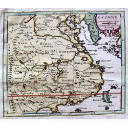
La Chine.
Lovely example of Giustiniani’s uncommon map of China from his “Atlas Abreviado”.
Date: Amsterdam, 1739
Selling price: ????
Please login to see price!
Sold
An exact map of the CRIM (Formely Taurica Chersonesus) Part of Lesser Tartary, the Sea of Asoph, and the adjacent Country of the Kuban Tartars. . .
Detailed and handsome wood block printed map centered on the Sea of Azov detailing the ongoing war between the Russians and Turks. The map is filled troop locations and b...
Date: London, 1739
Selling price: ????
Please login to see price!
Sold in 2010
![[Title page] Atlas Historique. Tome II.](/uploads/cache/15044-250x250.jpg)
[Title page] Atlas Historique. Tome II.
Printed title page in beautiful hand color, filled with allegorical figures. Prepared by Romeijn de Hooghe and engraved by Sluyter.More about title pages [+]
Date: Amsterdam, 1705-1739
Selling price: ????
Please login to see price!
Sold in 2021
Imperii Russici et Tartariae Universae tam majoris Afiaticæ quam minoris et EuropæTabula.
The map is of interest for the use of East Sea, the sea between Korea and Japan, here called "Mere Orientale Minus".Decorative map covering Russia, Tibet, China...
Date: Nuremberg, 1739
Selling price: ????
Please login to see price!
Sold in 2012
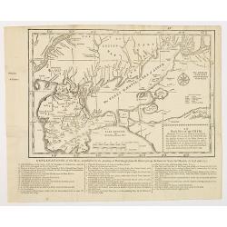
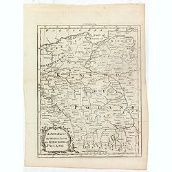
A map of the eastern map of Poland. . .
Drawn by Thomas Kitchin and published in the London Magazine. Cities, towns and geographical features are all shown. Department boundaries within Poland are marked with d...
Date: London, 1739
Selling price: ????
Please login to see price!
Sold in 2012
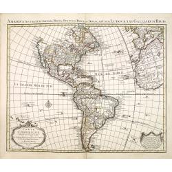
Carte d\'Amerique dressée par l\'usage du Roy..
Fine map prepared by G.d'Isle depicting North and south America, the west coast taken north to Cap Mendocin and Cap Blanc with a note Entrée decouverte par Martin d'Agui...
Date: Amsterdam, 1739
Selling price: ????
Please login to see price!
Sold in 2013
Carte d'Afrique dressée par l'usage du Roy. . .
Fine map prepared by G.d'Isle depicting the African continent.The re-engraved Amsterdam edition, of this fine map of Africa prepared by Guillaume delisle.The cartography ...
Date: Amsterdam, 1739
Selling price: ????
Please login to see price!
Sold in 2014
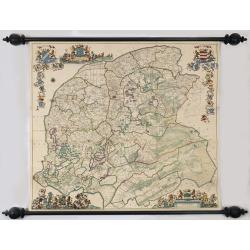
Nieuwe caert van Frieslant vermeerdert en verbetert op ordre en Gedeputeerde Staten door Bernard Schotanus à Sterringa vervaardigd en verbeterd door Johan Vegelin van Claerenbergen.
This very decorative wallmap - the so-called 'Vegelin-map' - is showing the Friesland counties, Oostergo, Westergo and Zevenwolden. The map is embellished with the coats ...
Date: Amsterdam, 1739
Selling price: ????
Please login to see price!
Sold
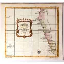
Coste Occidentale D'Afrique Depuis le XIe. Degre De Latitude Meridional
Detailed map featuring the southwest coast of Africa from “Cap de Bonne Esperance” (Cape of Good Hope), “Hottentots” (modern South Africa) in the south to “St. ...
Date: Paris, 1739
Selling price: ????
Please login to see price!
Sold in 2016
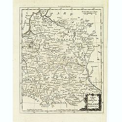
A new map of the western part of the Kingdom of Poland.
Drawn by Thomas Kitchin and published in the London Magazine. Cities, towns and geographical features are all shown. Department boundaries within Poland are marked with d...
Date: London, 1739
Selling price: ????
Please login to see price!
Sold in 2016
Rome Ancienne et Moderne.
Fine plan of ancient Rome with extensive key to principal buildings in town, from the most remarkable Atlas Historique et Méthodique published by L'Honore & Chatelai...
Date: Amsterdam, 1705-1739
Selling price: ????
Please login to see price!
Sold in 2020
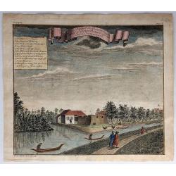
Ein Prospect der Baterie Anjol Eine Stunde von Batavia...
A pleasing view of the battery in Batavia, Indonesia. Batavia was the name of the capital city of the Dutch East Indies, and corresponds to the present-day city of Jakart...
Date: Frankfurt, 1739
Selling price: ????
Please login to see price!
Sold in 2018

Gerard Mercator.
Rare portrait of Gerard Mercator by Nicolas III de Larmessin (1684–1755). Published in the first volume of Joannis Francisci Foppens' Bibliotheca Belgica in 1739.For ne...
Date: Brussels, 1739
Selling price: ????
Please login to see price!
Sold in 2017
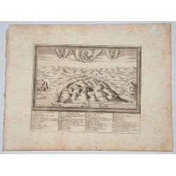
NORTH ISRAEL / MOUNT CARMEL.
A bird's eye view / map of the Holy Land from Haifa to Cesaria - Jerusalem centered on mount Carmel. Taken from the book: Conventuum fratrum Discalceatorum Ordinis B VIRG...
Date: Rome, 1739
Selling price: ????
Please login to see price!
Sold in 2017
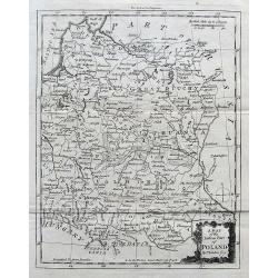
A Map of the Eastern Part of Poland.
A seldom-seen small map of parts of today's Poland, Lithuania, Latvia, Belarus, and Ukraine.
Date: London, ca. 1739
Selling price: ????
Please login to see price!
Sold in 2017

Stanislao Leczinski Re di Polonia, Gran Duca di Lituania.
Portrait of Stanislaw I Leszczynski ( 20 October 1677 – 23 February 1766) was King of Poland, Grand Duke of Lithuania, Duke of Lorraine and a count of the Holy Roman Em...
Date: Venice, 1739
Selling price: ????
Please login to see price!
Sold in 2022
![[Untitled Martime Chart.]](/uploads/cache/43629-250x250.jpg)
[Untitled Martime Chart.]
One double page maritime chart from John Pine's Tapestry hangings of the House of Lords Representing the Engagements between the English and Spanish Fleets in the year 15...
Date: London, 1739
Selling price: ????
Please login to see price!
Sold in 2023
An Exact Map of the Crimea. . .
A fascinating map of the Crimea, the Sea of Azov and Lesser Tartary, illustrating the Russian and Turkish conflict in the region. The map is filled with troop locations a...
Date: London, 1739
Selling price: ????
Please login to see price!
Sold in 2019
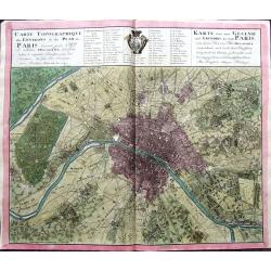
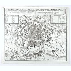
Carte Topographique des Environs & du Plan de Paris levée par Msr. l'Abbé Delagrive & copiée selon l'original Parisien. . .
An unusual plan of old Paris, based on Abbé Jean Delagrive's map of 1738. In the map many of today's city districts appear as villages. Highly detailed, showing the terr...
Date: Nuremberg, 1739
Selling price: ????
Please login to see price!
Sold in 2019