Subscribe to be notified if similar examples become available.
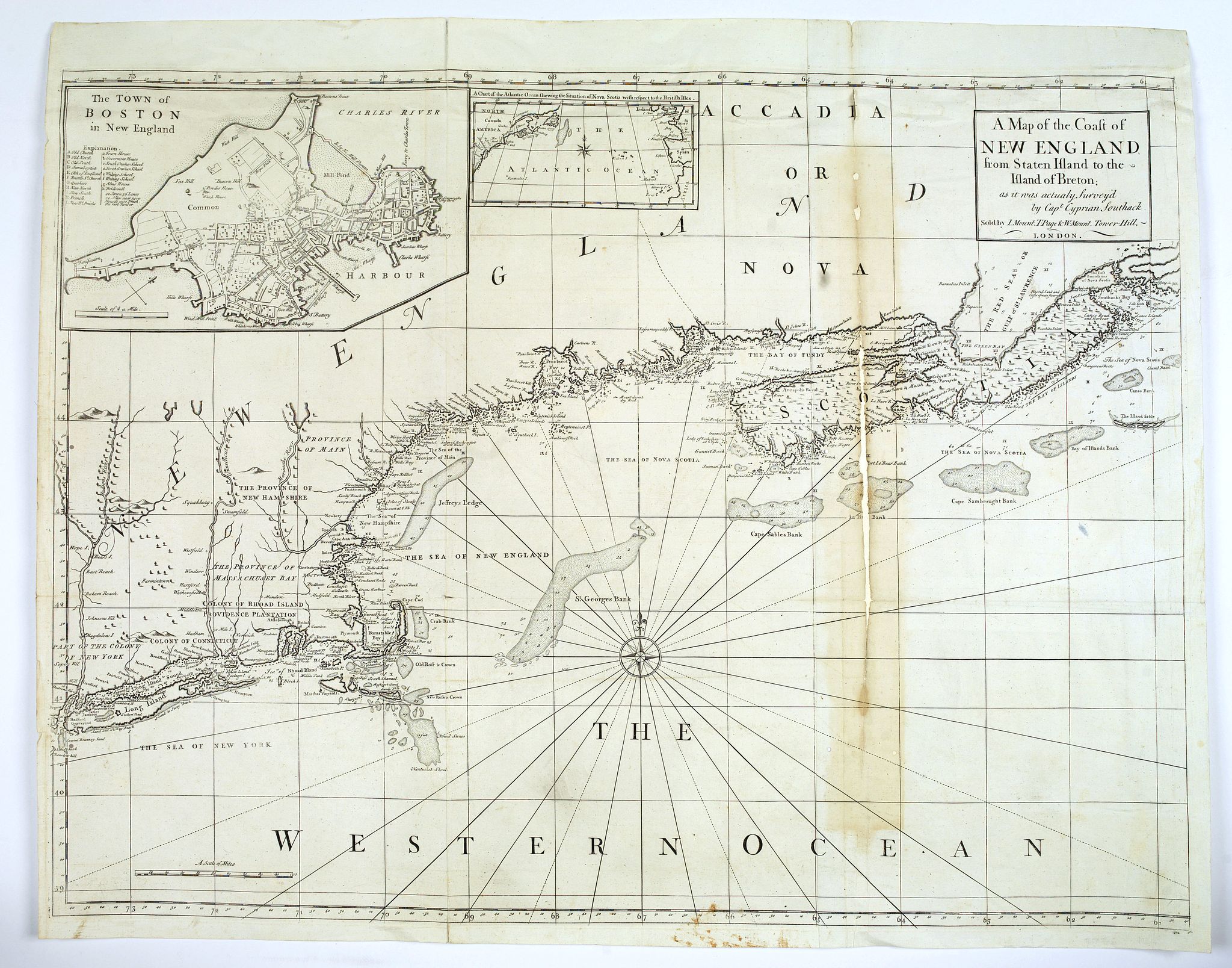
A Map of the Coast of New England from Staten Island to the island of Breton. . . |
||||||||||||||||||||
|
||||||||||||||||||||
|
|
||||||||||||||||||||
|
Selling price: $ Please login to see price!
Sold in 2017 Missed this item! Add your name to our mailing list and be the first to get notified about our newly added listings. . |
My Collection +
Add this or any of your favorite items in one place. If you want to save the items permanently, you have to sign in or create an account first. |
|||||||||||||||||||
Description
From the first marine atlas produced in the colonies was drawn by Captain Cyprian Southack (1662-1745). He is of great importance in North American cartography
Of the first five printed maps published in North America four are by Southack. Two of these do not survive in any known example. Of the original eight-sheet map only eight known 'complete' examples survive in the various editions.
Southack was born in England and followed his father's footsteps into the navy. He was only 10 years old when he first took part in a sea-battle. At 23 he went to Boston and entered into the service of the colony of Massachusetts.
In 1690, Southack as part owner and captain of the man-of-war Mary, was hired to join the Phips expedition in the sacking of Port Royal. He was to journey up the coast on raids to Acadia on at least two other occasions.
In 1704, under John March, and again in 1707 under Benjamin Church. He did not take part in Walker’s aborted mission against Quebec in 1711 but took an active role in the planning stages. He was already gaining a reputation as a cartographer.
His home remained in Boston where Southack married Elizabeth Oakley and had 11 children. He took a significant role in the administration at Annapolis Royal and was appointed to its first Council in 1720. All the time Southack continued his trading and fishing activities.
The eight-sheet marine atlas was first published in London sometime between 1729 and 1731. In 1732 a reduction in two sheets, in similar proportions, was published in the ‘English Pilot Fourth Book’, it was dated 1731. At an unknown date most likely not much later this less elongated map was published separately by John Senex, it covered the same territory.
The map depicts the north-east coast from New York to the eastern tip of Nova Scotia. This was a functional chart and as such includes large numbers of soundings, hazards and sand banks. The cartography is still lacking somewhat in accuracy even in the New England coastline but is still a great leap from earlier maps. Its key importance is not the relative accuracy of the coastlines but the detail within.
There are distortions to Massachusetts coastline and Nova Scotia. Topographical detail is included, particularly in Nova Scotia and New England where it extends inland in detail featuring the Hudson, Connecticut and Merrimack Rivers. Along with an inset of the North Atlantic Ocean there is one of the ‘Town of Boston’ derived from John Bonnor’s plan of 1722. This is an addition which was not present on the original eight-sheet map.
Of the two reductions this is the only one to bear Southack’s name alluding possibly to the more official approval given this by him.
Indeed Baynton-Williams suggests that the eight-sheet might have been engraved by Senex also. There are four states of the map, a second also by Senex added a third sheet extending the map to Newfoundland effectively covering the entrance to the St. Lawrence River. A third state omitting the extended sheet was issued by William Herbert and Robert Sayer.
This fourth and last state was published by the firm of Mount and Page and included in editions of the ‘English Pilot Fourth Book’ from 1775 to 1794.
A similar conditioned example sold at Swann Galleries 5 December 1996 lot 251 where it sold for $2,530.
Reference: Baynton-Williams ‘The Charting of New England’ no. 82, Le Gear ‘The New England Coasting Pilot of Cyprian Southack’ in Imago Mundi no. 11 pp. 137-44, McCorkle 735.1, Sellers & Van Ee 204.
FAQ - Guarantee - Shipping
Buying in the BuyNow Gallery
This item is available for immediate purchase when a "Add to Cart" or "Inquire Now" button is shown.
Items are sold in the EU margin scheme
Payments are accepted in Euros or US Dollars.
Authenticity Guarantee
 We provide professional descriptions, condition report (based on 45 years experience in the map business)
Paulus Swaen warrants the authenticity of our items and a certificate of authenticity is provided for each acquired lot.
Condition and Coloring
We indicate the condition of each item and use our unnique HiBCoR grading system in which four key items determine a map's value: Historical Importance, Beauty, Condition/Coloring and Rarity.
Color Key
We offer many maps in their original black and white condition. We do not systematically color-up maps to make them more sellable to the general public or buyer.
Copper engraved or wood block maps are always hand colored. Maps were initially colored for aesthetic reasons and to improve readability. Nowadays, it is becoming a challenge to find maps in their original colors and are therefor more valuable.
We use the following color keys in our catalog:
Original colors; mean that the colors have been applied around the time the map was issued.
Original o/l colors; means the map has only the borders colored at the time of publication.
Colored; If the colors are applied recently or at the end of the 20th century.
Read more about coloring of maps [+]
Shipping fee
A flat shipping fee of $ 30 is added to each shipment by DHL within Europe and North America. This covers : International Priority shipping, Packing and Insurance (up to the invoice amount).
Shipments to Asia are $ 40 and rest of the world $50
We charge only one shipping fee when you have been successful on multiple items or when you want to combine gallery and auction purchases.
Read more about invoicing and shipping
FAQ
Please have a look for more information about buying in the BuyNow gallery
Many answers are likely to find in the general help section.
My Collection+
![]()
With My Collection+ you can collect all your favorite items in one place. It is free, and anyone can create his or her virtual collection.
Unless you are logged in, the item is only saved for this session. You have to be registed and logged-in if you want to save this item permanently to My Collection+.
Read More[+]
Register here, it is free and you do not need a credit card.
Add this item to
My Collection+
or click the following link to see My Collection+.
| Digital Image Download | |
|
Paulus Swaen maintains an archive of most of our high-resolution rare maps, prints, posters and medieval manuscript scans. We make them freely available for download and study. Read more about free image download |
Click the image for a free small image download. |
In accordance with the EU Consumer Rights Directive and habitually reside in the European Union you have the right to cancel the contract for the purchase of a lot, without giving any reason.
The cancellation period will expire 14 calendar days from the day after the date on which you or a third party (other than the carrier and indicated by you) acquires, physical possession of the lot. To exercise the right to cancel you must inform Paulus Swaen Inc, of your decision to cancel this contract by a clear statement (e.g. a letter sent by post, or e-mail.
To meet the cancellation deadline, it is sufficient for you to send your communication concerning your exercise of the right to cancel before the cancellation period has expired.
