Browse Listings
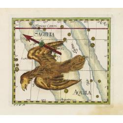
Sagitta.
Uncommon celestial print of Sagitta, published by C.Thomas in the Mercurii philosophici firmamentum firmianum descriptionem et usum globi artificialis coelestis. Individu...
Date: Frankfurt & Leipzig, 1730
Selling price: ????
Please login to see price!
Sold
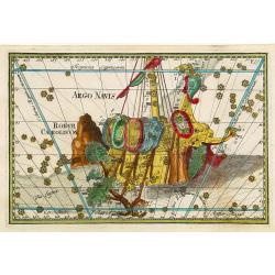
Argo Navis
Uncommon celestial print of Argo Navis, published by C.Thomas in the Mercurii philosophici firmamentum firmianum descriptionem et usum globi artificialis coelestis. Indiv...
Date: Frankfurt & Leipzig, 1730
Selling price: ????
Please login to see price!
Sold
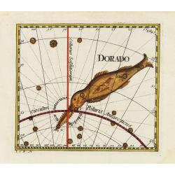
Dorado.
Uncommon celestial print showing the constellation of Dorado, published by C.Thomas in the Mercurii philosophici firmamentum firmianum descriptionem et usum globi artific...
Date: Frankfurt & Leipzig, 1730
Selling price: ????
Please login to see price!
Sold
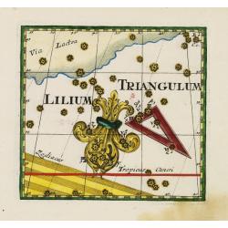
Lilium and Triangulum.
Uncommon celestial print showing the constellation of Lilium and Triangulum, published by C.Thomas in the Mercurii philosophici firmamentum firmianum descriptionem et usu...
Date: Frankfurt & Leipzig, 1730
Selling price: ????
Please login to see price!
Sold
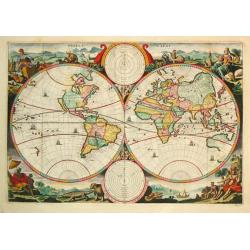
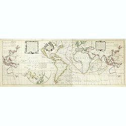
Werelt Caert.
Dutch so-called ' Staten' bibles, published between 1637 and c. 1760, contained 5 maps: The World, ' Paradise', The Perigrinations, The Promised Land Canaan, The Travels ...
Date: Amsterdam, c. 1730
Selling price: ????
Please login to see price!
Sold
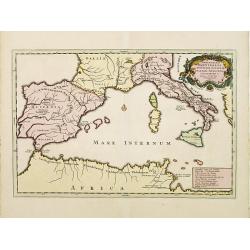
Expeditiones Hannibalis per Hispaniam, Galliam, Italiam, Africam &cc..
Map covering the Eastern part of the Mediterranean Basin as far as the Adriatic Sea. It illustrates the route of Hannibal through Northern Africa and southern Europe as f...
Date: Amsterdam 1730
Selling price: ????
Please login to see price!
Sold
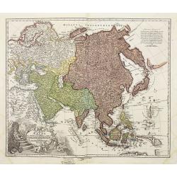
Recentissima Asiae Delineatio..
A fine example of this detailed map of Asia showing the outlines of New Holland, Terre des Papons, Nova Britannia and Capentaria. The cartouche shows a Sultan on his thro...
Date: Nuremberg 1730
Selling price: ????
Please login to see price!
Sold
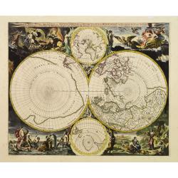
Les Deux Poles Arctique ou Septentrional, et Antarctique..
The distinctive attractiveness of many of the later seventeenth century Dutch world maps is to be found in their border decorations. Nicolaes Berchem has introduced drama...
Date: Amsterdam, 1730
Selling price: ????
Please login to see price!
Sold
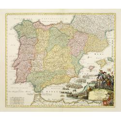
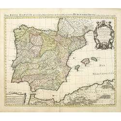
Regnorum Hispaniae et Portugalliae tabula Generailis..
Fine map of Spain and Portugal, including Majorca and Minorca. Exceptionally detailed, but the most remarkable feature of the engraving is the large title-piece showing a...
Date: Nuremberg 1730
Selling price: ????
Please login to see price!
Sold
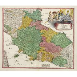
Status ECCLESIASTICI magnique ducatus Florentini..
Fine example in striking colors, of Central Italy, from Ferrara, Parma and Cremona to Territorium Romanum, centered on Florence and Sienna and showing Rome. Decorative la...
Date: Nuremberg 1730
Selling price: ????
Please login to see price!
Sold
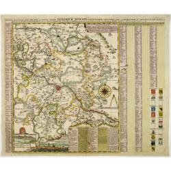
Accurate Geographische delineation der Dioeces und des Ammtes DRESDEN. . .
Uncommon and decorative map of the area 25km around Dresden, reaching to Meissen, Königstein and Dippoldiswalde, prepared by Adam Friedrich Zürner. With an extensive ke...
Date: Amsterdam, 1730
Selling price: ????
Please login to see price!
Sold in 2011
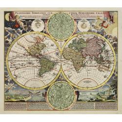
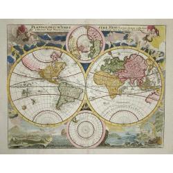
Planiglobii Terrestris Cum Utroq Hemisphaerio.
Decorative world map surrounded by vivid engravings of natural phenomena such as waterspouts, a rainbow, earthquakes, and a volcano. Wind heads occupy the starry heavens,...
Date: Nuremberg, 1730
Selling price: ????
Please login to see price!
Sold
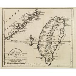
Das Eyland Formosa und ein stück von den Küsten von China..
A rare German edition of this well-known map of Taiwan, based on Jesuit information. The text along the island's east-coast claims: Of this coast little is known .
Date: Paris 1730
Selling price: ????
Please login to see price!
Sold
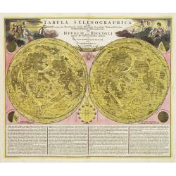
Tabula selenographica.. Hevelii quam Riccioli..
The moon map has been published on the J.G.Doppelmayer Atlas Coelestis.It shows two representations of the surface of the Moon, with names of seas and craters introduced ...
Date: Nuremberg 1730
Selling price: ????
Please login to see price!
Sold
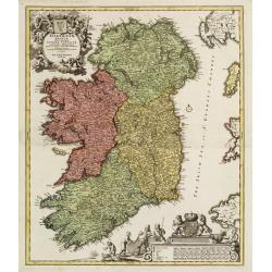
Hiberniae regnum..
A detailed and decorative map of Ireland, with an attractive uncolored title cartouche.
Date: Nurnberg 1730
Selling price: ????
Please login to see price!
Sold
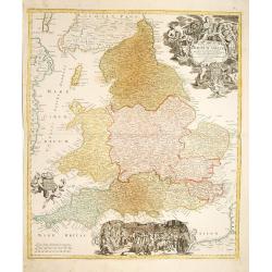
Regnum Angliae..
A detailed and decorative map of England, with an attractive uncolored title cartouche. Made after Visscher.
Date: Nurnberg 1730
Selling price: ????
Please login to see price!
Sold
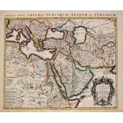
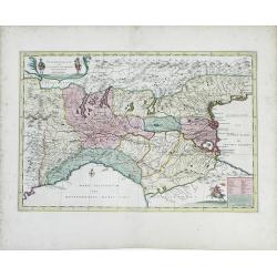
Carte de la Turquie de l'Arabie et da le Perse.
Superb map of the Ottoman Empire stretching from the Balkans through present-day Turkmenistan in the north and including Northeastern Africa and the Arabian Peninsula. Th...
Date: Amsterdam, c. 1730
Selling price: ????
Please login to see price!
Sold in 2016
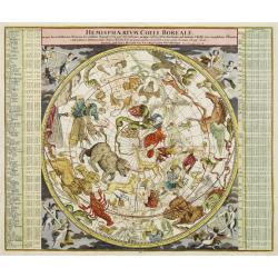
Hemisphaerium Coeli Boreale..
A magnificent celestial chart drawn by the famous scientist Johann Gabriel Doppelmayer. Large circular chart of the northern hemisphere constellations, with decorative vi...
Date: Nuremberg 1730
Selling price: ????
Please login to see price!
Sold
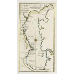
Reduction De La Carte De La Mer Caspienne..
Uncommon map of the Caspian Sea. Engraved by de Berey.
Date: Paris c.1730
Selling price: ????
Please login to see price!
Sold
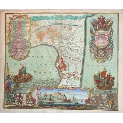
Accurate Vorstellung der Beruhmten... der Königlich Dähnischen..
A map of the Sond between Sweden and Denmark and its approach into Copenhagen. With a bird's eye-view of the Danish capital at the bottom.Surrounding the map are three in...
Date: Nuremberg , ca. 1730
Selling price: ????
Please login to see price!
Sold
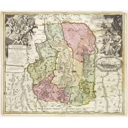
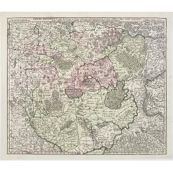
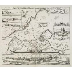
Protoparchiae Mindelhemensis nova tabula geographica...
Detailed map of the area 15km around Mindelheim in southern Germany with large cartouche with cherubs and coat of arms.In the right hand side inset prospect of Mindelheim...
Date: Nuremberg , ca. 1730
Selling price: ????
Please login to see price!
Sold in 2013
Geographica Nova ex Oriente gratiosissima, duabus tabulis specialissimis contenta, quarum una Mare Caspium..
Map of the Caspian Sea and the peninsula of Kamchatka (Jedso) in northeast Asia on one sheet.Separated by an attractive panel with figurative title cartouche, cherubs, an...
Date: Nuremberg 1730
Selling price: ????
Please login to see price!
Sold
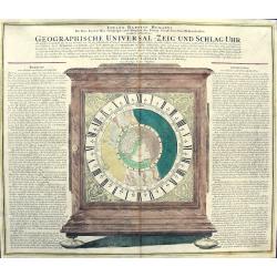
GEOGRAPHISCHE UNIVERSAL - ZEIG UND SCHLAG - UHR
Map of the Northern Hemisphere showing California as an Island. Inspired by the German clockmaker Zacharias Landteck. The map is contained within an engraved table case ...
Date: Nuremberg, c1730
Selling price: ????
Please login to see price!
Sold in 2011
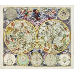
Planisphaerium Coeleste.
Magnificent double hemisphere celestial chart showing the northern and southern sky with constellations in allegorical form derived from Hevelius.A diagram in the upper l...
Date: Augsburg, 1730
Selling price: ????
Please login to see price!
Sold in 2024
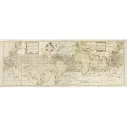
Nova & Accuratismia Totius Terrarum Tabula Nautica Variationum Magneticarum Index Juxta Obserations Anno 1706 habitas Constructa per Edm. Halley.
Dutch publication of Halley's important chart demonstrating the variations of the compass, created by him in 1701. Though best known as the discoverer of the comet which ...
Date: Amsterdam 1702/ 1730
Selling price: ????
Please login to see price!
Sold
Imperii Moscovitici pars Australis..
Detailed map centered on Moscow.
Date: Augsburg 1730
Selling price: ????
Please login to see price!
Sold
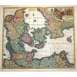
Daniae Regnum cum Ducatu Holstiae et Slesvici.
Fine copper engraved map, hand-colored in outline & wash, featuring Denmark, with its neighbouring counties around the Baltic Sea and Schagerack. Map has a decorative...
Date: Augsburg, 1730
Selling price: ????
Please login to see price!
Sold in 2013
Werelt Caert Orbis terrarum
Lovely double hemisphere map from a Dutch Bible. Title inside the surrounding allegorical representations of the continents, based on Visscher. CALIFORNIA IS AN ISLAND wi...
Date: Amsterdam, 1730
Selling price: ????
Please login to see price!
Sold
Planiglobium Terrestre Minus in hanc formam reductam
This uncommon map is based on Johann Baptist Homann's Planiglobii Terrestris Cum Utrog Hemisphaerio Caelesti and is embellished with similar engravings of natural phenome...
Date: Nuremberg, 1730
Selling price: ????
Please login to see price!
Sold
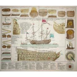
Neue Tafel vor alle Liebhabers und See-fahrende..
Large sheet with construction and rigging detail of a three-masted 96 gun man-o-war. The rendering provides great detail of the ship's equipment, construction, rigging, e...
Date: Nuremberg, 1730
Selling price: ????
Please login to see price!
Sold
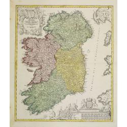
Hiberniae regnum. . .
A detailed and decorative map of Ireland, with an attractive uncolored title cartouche.
Date: Nurnberg 1730
Selling price: ????
Please login to see price!
Sold in 2010
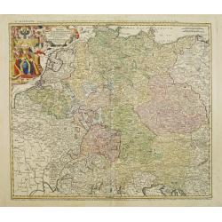
Imperii Romano Germanici. . .
A beautifully colored regional map of the XVIII century German Empire.Ornamental title cartouche in the upper left has been hand colored in recent colors.
Date: Nuremberg, 1730
Selling price: ????
Please login to see price!
Sold in 2008
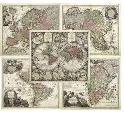
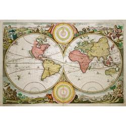
Diversi GLOBI TERR-AQUEI Statione Variante et Visu intercedente,. . .
A matching set of the world in double hemispheres and maps of the four continents.Here in a first edition without the privilege.Diversi GLOBI TERR-AQUEI Statione Variante...
Date: Augsbourg, c.1730
Selling price: ????
Please login to see price!
Sold in 2011
Milazzo olim Mylae, munitissimum Siciliae castellum.
Exceptional plan and view of the city of Milazzo, in Sicily. One of the most beautiful and sought after views from Seutter. A few imperfections, exceptional old colors, p...
Date: Augsburg, 1730
Selling price: ????
Please login to see price!
Sold in 2013
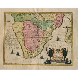
Aethiopia inferior vel exterior ...
Blaeu's landmark map of Southern Africa, here in the final De Wit edition of 1695 published by Covens and Mortier ca. 1730. Blank on verso. This final print saw an almost...
Date: Amsterdam, 1730
Selling price: ????
Please login to see price!
Sold in 2008
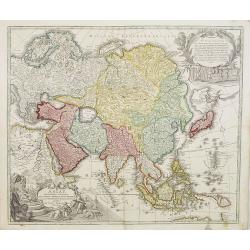
Asiae Recentissima Delineatio, Qua Status Imperia totius Orientalis. . .
This state appears to be an update of his father's Asia map of c.1712 (Sweet 109). An important innovation is the appearance of Kamchatka, which is represented as a huge ...
Date: Nuremberg 1730
Selling price: ????
Please login to see price!
Sold in 2008

Recentissima Asiae Delineatio. . .
A fine example of this detailed map of Asia showing the outlines of New Holland, Terre des Papons, Nova Britannia and Capentaria. The cartouche shows a Sultan on his thro...
Date: Nuremberg, 1730
Selling price: ????
Please login to see price!
Sold in 2008
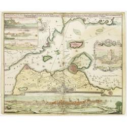
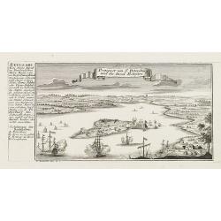
Prospect von S. Petersburg und der Insul Retufari.
Decorative view of Saint Petersburg, with a description and key to the left.
Date: Augsburg, 1730
Selling price: ????
Please login to see price!
Sold in 2008
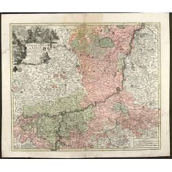
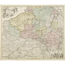
L'Eveche et L'Etat de Liege Avec les appartenances designées dans les pais voisins Delineation nouvelle et exacte Aux depens de Matthieu Seutter
Beautiful cooper engraved map of the central part of Belgium and parts of the Netherlands by M. Seutter. Showing the area around Liège and Maastricht. The nice...
Date: Augsburg, 1730
Selling price: ????
Please login to see price!
Sold in 2009
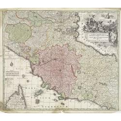
Novissima et accuratissima Delineatio Status Ecclesiae, et Magni Ducatus Hetruriae . . .
Striking map of Central Italy, from Mantua, Cremona, Piacenza and Ferrara in the north to Roma in the South and including Ancon on the Adriatic. Centered on Florence and ...
Date: Paris, 1730
Selling price: ????
Please login to see price!
Sold in 2009
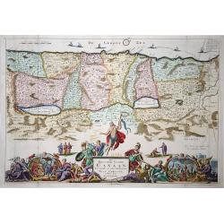
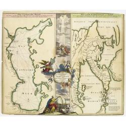
Het Beloofde Landt Canaan..
Het Beloofde Landt Canaan door wandelt van onsen Salichmaecker Iesu Christo, neffens syne Apostelen. Fine map of Israel with north oriented to right. Large decorative tit...
Date: Amsterdam, 1730
Selling price: ????
Please login to see price!
Sold in 2009
Prospect von S. Petersburg und der Insul Retufari.
Bird's-eye view of the island Retufari, with according to the key the town of Saint Petersburg (A) in background. With a description in German to the left.
Date: Augsburg, 1730
Selling price: ????
Please login to see price!
Sold in 2009
Accurate Vorstellung der Beruhmten ? der Königlich Dähnischen ?
A map of the Sond between Sweden and Denmark and its approach into Copenhagen. With a bird's eye-view of the Danish capital at the bottom.Surrounding the map are three in...
Date: Nuremberg , ca. 1730
Selling price: ????
Please login to see price!
Sold in 2009
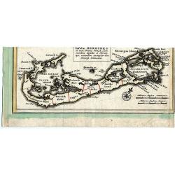
Insulae Bermudes in suas Tribus divisae...
Copper-engraved map of Bermuda most probably from a larger Homann composite sheet showing also other islands. Shows the island in good detail, naming towns and villages, ...
Date: Nuremberg, c1730
Selling price: ????
Please login to see price!
Sold in 2011
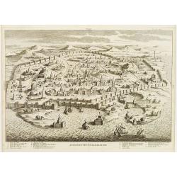
Ancienne Veue D'Alexandrie.
Highly decorative bird's-eye view of Alexandria, taken from "Dictionnaire Historique et critique de la Bible" by Abbé Calmet.It illustrates a detailed plan of ...
Date: Paris, 1722 - 1730
Selling price: ????
Please login to see price!
Sold in 2009
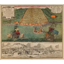
Algercum ?
One of Seutter's most decorative prospects, with a sea battle in the foreground.
Date: Augsburg, c.1730
Selling price: ????
Please login to see price!
Sold in 2010
Belgii Regii accuratissima Tabula, Auctore Fredericum de Witt. . .ex Officina R. et J. Ottens.
Map of the present-day Belgium. Ottens acquired the copper plate from Visscher and re-issued the map, adding his address to the title cartouche. Uncommon.Joachim Ottens (...
Date: Amsterdam, 1730
Selling price: ????
Please login to see price!
Sold in 2010
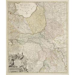
Ducatus Geldriae Nova Tabula In Tertachias Noviomagii, Arnhemii, Ruremondae in Zutphaniae Comitatum.
This is a uncommon re-issue of the copperplate of Nicolas Visscher. Including the area of Gelderland, Overijssel and Noord Limburg.Joachim Ottens (1663 - 1719) and his so...
Date: Amsterdam, 1730
Selling price: ????
Please login to see price!
Sold in 2020
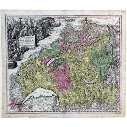
Mappa geographica illustris Helvetiorum reipublicæ Bernensis: cum adjacentibus pagorum et dynastiarum confiniis accurate delineata.
Striking map of Switzerland by Matthew Seutter.
Date: Augsburg, ca. 1730
Selling price: ????
Please login to see price!
Sold in 2010
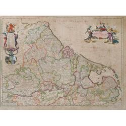
Novissima et accuratissima XVII Provinciarum Germania Inferior Tabula.
Finely detailed map of the Netherlands by Frederick de Wit. A large legend cartouche is in the top left, is the family crest and dedication to John Munter, mayor of Amste...
Date: Amsterdam, 1730
Selling price: ????
Please login to see price!
Sold in 2010
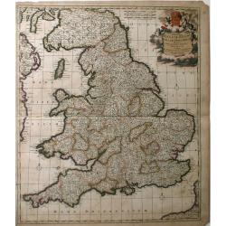
Accuratiffima Angliae Regni et Walliae Principatus Defcriptio Diftinete divifa in Omnes fuas Provincias et Edita.
A detailed map of Great Britain, Scotland and Wales by Frederick De Witt. Map includes islands off the coast of Britain and a small portion of the Northern Coast and the ...
Date: Amsterdam, 1730
Selling price: ????
Please login to see price!
Sold in 2010
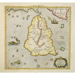
Tab. XII Asiae Taprobanam repraesentans Medius meridianus 125 ad quem reloqui inclinantur ratione aequin octalis et 9 septentrionalis
Ptolemaic map of Taprobana. The map itself depicts the island with the typical misconceptions of Ptolemy with the island straddling the Equator and showing a small part o...
Date: Amsterdam, 1578-1730
Selling price: ????
Please login to see price!
Sold in 2010

Tab.X Asiae Complectens Indiam intra gangem. . .
A Ptolemaic view of India. The Himalayan Mountains stretch across the top of the map and the Indus and Ganges river systems are well delineated. The subcontinent is consi...
Date: Amsterdam, 1730
Selling price: ????
Please login to see price!
Sold in 2010
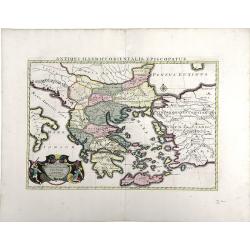
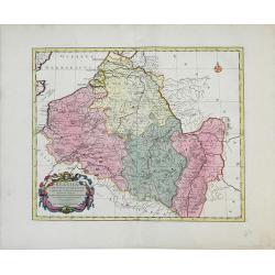
Antiquorum Illyrici Orientalis ...
Fine map of ancient Greece, Crete and Turkey by Sanson and published by the Covens and Mortier firm. Shows many ancient Greek cities and sites, such as Nicropolis, Athens...
Date: Amsterdam, 1730
Selling price: ????
Please login to see price!
Sold in 2010
Italia Gallicae Sive Galliae Cisalpinae. . .
Map of the region of Northern Italy, highlighting the areas of Gallia Transpadana, the region inhabited by the Celts between the Padus (now called Po River) and the Swiss...
Date: Amsterdam, 1730
Selling price: ????
Please login to see price!
Sold in 2010
Belgica in Provincias Quatuor et Populos Viginti aut circiter. . .
This map, published by Covens and Mortier, covers present-day Belgium, once known as Belgica, and the surrounding provinces. In the 1st century AD, the provinces of Gaul ...
Date: Amsterdam, 1730
Selling price: ????
Please login to see price!
Sold in 2010
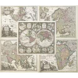
Diversi GLOBI TERR-AQUEI Statione Variante et Visu intercedente,...
A matching set of the world in double hemispheres and maps of the four continents.Here in a first edition without the privilege.Diversi GLOBI TERR-AQUEI Statione Variante...
Date: Augsbourg, 1730
Selling price: ????
Please login to see price!
Sold in 2010
Nova Regni Hispaniae accurata descriptio ad u sum serenissimi Burgundiae ducis.
Prepared by G.de L'Isle.The Amsterdam publishing firm of Covens and Mortier (1721 – c. 1862) was the successor to the extensive publishing empire build by Frenchman Pie...
Date: Amsterdam, 1730
Selling price: ????
Please login to see price!
Sold in 2010
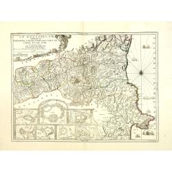
Le Roussillon Subdivisé en Cerdagne, Cap Sir, Conflans, Vals de Carol et de Spir ou se trouve encore le Lampourdan, Faisant Partie de la Catalogne.
Striking map of the region including part of the southeastern French Mediterranean coastline and neighboring Catalonia.This very decorative map includes in the lower left...
Date: Paris, 1730
Selling price: ????
Please login to see price!
Sold
![[title page] Recueil de Plusieurs plans des ports et rades de la Mer Mediterranée.](/uploads/cache/30131-250x250.jpg)
[title page] Recueil de Plusieurs plans des ports et rades de la Mer Mediterranée.
Title page from : Recueil des Plusieurs plans des ports et rades de la Mer Mediterranée.. Rich with details and symbolism. Cartouche from Michelot and Bremond small-scal...
Date: Marseille, 1730
Selling price: ????
Please login to see price!
Sold in 2013
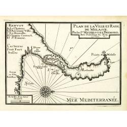
Plan de la Ville et Rade de Melasse.
An attractive chart centered on the Mediterranean. With scale and large compass-rose. Dated 1727, with the privilege of the King. From : Recueil des Plusieurs plans des p...
Date: Marseille, 1730
Selling price: ????
Please login to see price!
Sold in 2018
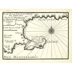
Plan de la Ville et Baye de Gayette.
An attractive chart centered on the Mediterranean. With scale and large compass-rose. Dated 1727, with the privilege of the King. From : Recueil des Plusieurs plans des p...
Date: Marseille, 1730
Selling price: ????
Please login to see price!
Sold in 2013
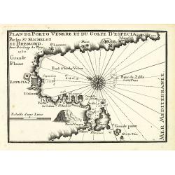
Plan de Porto Venere et du Golfe d'Especia.
An attractive chart centered on the Mediterranean. With scale and large compass-rose. Dated 1727, with the privilege of the King. From : Recueil des Plusieurs plans des p...
Date: Marseille, 1730
Selling price: ????
Please login to see price!
Sold in 2012
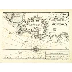
Plan de la Ville et Port de Livourne.
An attractive chart centered on Livorno. With scale and large compass-rose. Dated 1727, with the privilege of the King. From : Recueil des Plusieurs plans des ports et ra...
Date: Marseille, 1730
Selling price: ????
Please login to see price!
Sold in 2016
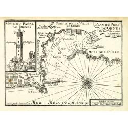
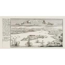
Plan du Port de Gênes.
An attractive chart centered on Genoa, with to the left an image of the 77-meter-tall Lanterna tower. With scale and large compass-rose. Dated 1727, with the privilege of...
Date: Marseille, 1730
Selling price: ????
Please login to see price!
Sold in 2012
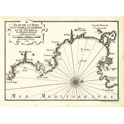
Plan de la Baye et Citadelle de Rose et de Tourrille.
An attractive chart centered on Tourrille and Roses in Catalonia. With scale and large compass-rose. Dated 1727, with the privilege of the King. From : Recueil des Plusie...
Date: Marseille, 1730
Selling price: ????
Please login to see price!
Sold in 2010
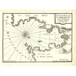
Plan du Port de Cadequié en Catalogne.
An attractive chart centered on the town and Bay of Cadequie or Cadaquez in Catalonia. With scale and large compass-rose. Dated 1727, with the privilege of the King. From...
Date: Marseille, 1730
Selling price: ????
Please login to see price!
Sold in 2010
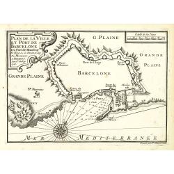
Plan de la Ville det Port de Barcelone.
An attractive chart centered Barcelona. With scale and large compass-rose. Dated 1727, with the privilege of the King. From : Recueil des Plusieurs plans des ports et rad...
Date: Marseille, 1730
Selling price: ????
Please login to see price!
Sold in 2010
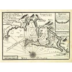
Plan de la Baye et Rade de Cadis.
An attractive chart of Cadiz. With scale and large compass-rose. Dated 1730, with the privilege of the King. From : Recueil des Plusieurs plans des ports et rades de la M...
Date: Marseille, 1730
Selling price: ????
Please login to see price!
Sold in 2012
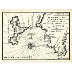
Partie de l'isle d'Yvice, et des isles fromentières.
An attractive chart centered on the south coasts of Ibiza and the Island of Formentera. With scale and large compass-rose. Dated 1730, with the privilege of the King. Fro...
Date: Marseille, 1730
Selling price: ????
Please login to see price!
Sold
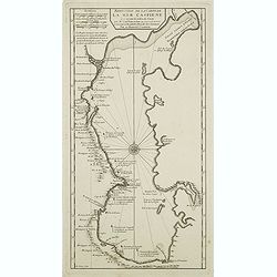
Reduction De La Carte De La Mer Caspienne. . .
Uncommon map of the Caspian Sea. Engraved by de Berey.
Date: Paris, c.1730
Selling price: ????
Please login to see price!
Sold in 2011
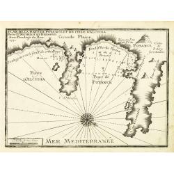
Plan de la Baye de Poyance et de celle d'Alcudia.
An attractive chart centered on the Mediterranean. With scale and large compass-rose. Dated 1727, with the privilege of the King. From : Recueil des Plusieurs plans des p...
Date: Marseille, 1730
Selling price: ????
Please login to see price!
Sold
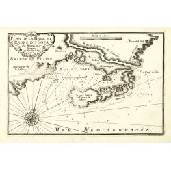
Plan de la Baye et Rades du Sofa.
An attractive chart centered on the Mediterranean. With scale and large compass-rose. Dated 1727, with the privilege of the King. From : Recueil des Plusieurs plans des p...
Date: Marseille, 1730
Selling price: ????
Please login to see price!
Sold in 2022
Accurata Utopiae Tabula das ist der Neu entdeckten Schalck Welt. . .Schlarraffenlandes. . .
Despite the name Utopia in the title, this is not Thomas More's ideal society: Schlarraffenlandes is the German Fool's Paradise, a land of vice and debauchery, from a sat...
Date: Nuremberg, 1730
Selling price: ????
Please login to see price!
Sold in 2011
Carte Generale du Monde, ou Description du Monde Terrestre & Aquatique
Pierre Mortier's unique world map drawn on Mercator's projection with California as an island and the Detroit d'Anian connected by dotted lines through the Northwest Pass...
Date: Amsterdam, 1730
Selling price: ????
Please login to see price!
Sold in 2011
Nova & Accuratismia Totius Terrarum Tabula Nautica Variationum Magneticarum Index Juxta Obserations Anno 1706 habitas Constructa per Edm. Halley.
Dutch publication of Halley's important chart demonstrating the variations of the compass, created by him in 1701. Though best known as the discoverer of the comet which ...
Date: Amsterdam, 1702/ 1730
Selling price: ????
Please login to see price!
Sold in 2011
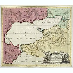
Nova Mappa Geographica Maris Assoviensis Vel De Zabache Et Paludis Maeotidis accurate aeri incis et in luce edita . . .
Striking map of the Sea of Azov with adjacent countries and the Strait of Kerch, with a decorative allegorical cartouche, showing the costumes of the indigenous people of...
Date: Augsburg, 1730
Selling price: ????
Please login to see price!
Sold in 2020
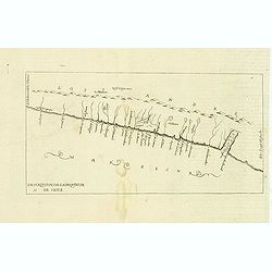
Descripcion de la provincia de Chile.
Map of the Chile. Cartographic elements include topographical details and location of some rivers and settlements. The map was copied from the manuscript map of Juan Lóp...
Date: Madrid, 1730
Selling price: ????
Please login to see price!
Sold in 2012
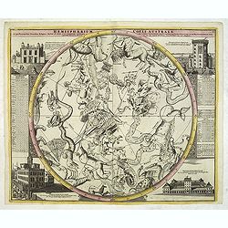
Hemisphaerium Coeli Australe. . .
Large celestial chart depicting the constellations in the southern sky. Johann Gabriel Doppelmayr was a professor of mathematics at the Aegidien Gymnasium in Nuremberg. H...
Date: Nuremberg, 1730
Selling price: ????
Please login to see price!
Sold in 2013
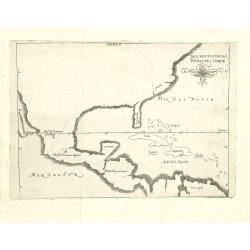
Descripcion de las Yndias des Norte. 2.
Rare map of the Americas, one of the very few Spanish printed maps of America, first published in the 1601 first edition of Herrera's Historia General, the present map ap...
Date: Madrid, 1726, 1728, 1730
Selling price: ????
Please login to see price!
Sold in 2012