Browse Listings
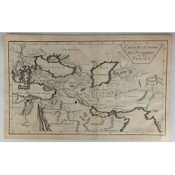
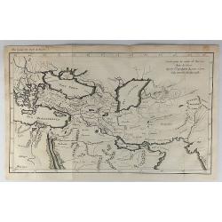
Carte de L'Empire des Assiriens et des Perses.
Striking map of Persia and Arabia. It is from “METHODE POUR ETUDIER L’HISTOIRE” by L’Abbe Lenglet du Fresnoy, pulished in Paris in 1729. The map is quite rare and...
Date: Paris, 1729
Selling price: ????
Please login to see price!
Sold in 2023
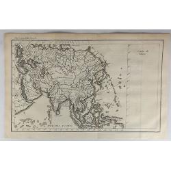
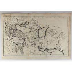
Carte de l'Asie.
A striking map of Asia. It is from “METHODE POUR ETUDIER L’HISTOIRE” by L’Abbe Lenglet du Fresnoy, published in Paris in 1729. The map is quite rare, and is not n...
Date: Paris, 1729
Selling price: ????
Please login to see price!
Sold in 2021

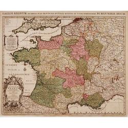
Carte du Royaume de France.
A striking map of France, from the “METHODE POUR ETUDIER L’HISTOIRE” by L’Abbe Lenglet du Fresnoy, published in Paris in 1729. The map is quite rare and is not no...
Date: Paris, 1729
Selling price: ????
Please login to see price!
Sold in 2019
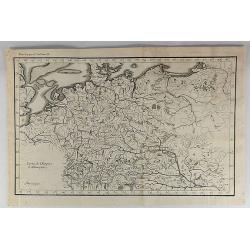
Carte de l'Empire d'Allemagne.
A striking map of Germany, from “METHODE POUR ETUDIER L’HISTOIRE” by L’Abbe Lenglet du Fresnoy, published in Paris in 1729. The map is quite rare and is not on or...
Date: Paris, 1729
Selling price: ????
Please login to see price!
Sold in 2019
Methode Pour Etudier L'Histoire.
A striking map of Germany, from “METHODE POUR ETUDIER L’HISTOIRE” by L’Abbe Lenglet du Fresnoy, published in Paris in 1729. The map is quite rare and is not now o...
Date: Paris, 1729
Selling price: ????
Please login to see price!
Sold in 2021
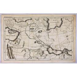
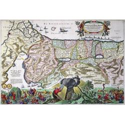
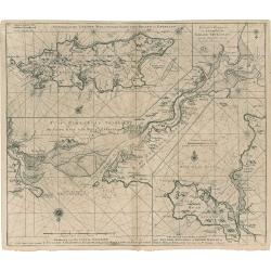
Carte pour la Route de Xerxes dans la Grece et Pour l'Expedition du Jeune Cyprus et la Retraite des Dix Mille.
A striking map of Greece. The map for the Route of Xerxes in Greece and For the Expedition of the Young Cyprus, and the Retreat of the Ten Thousand. It is from “METHODE...
Date: Paris, 1729
Selling price: ????
Please login to see price!
Sold in 2020
Empire et Conquetes d'Allexandre.
A striking map of Greece during the time of 'Alexander the Great,' showing his conquests. It is from “METHODE POUR ETUDIER L’HISTOIRE” by L’Abbe Lenglet du Fresno...
Date: Paris, 1729
Selling price: ????
Please login to see price!
Sold in 2019
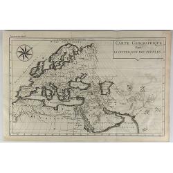
Carte Geographique Pour la Dispersion des Peuples.
A striking map of the ancient world (Europe, North Africa & Western Asia) shows people's dispersion. It is from “METHODE POUR ETUDIER L’HISTOIRE” by L’Abbe Le...
Date: Paris, 1729
Selling price: ????
Please login to see price!
Sold in 2018
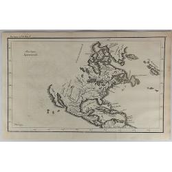
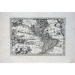
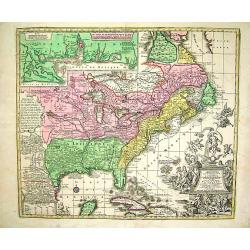
Amerique Septentrionale.
An interesting map of North America, from “METHODE POUR ETUDIER L’HISTOIRE” by L’Abbe Lenglet du Fresnoy, published in Paris in 1729. The map is quite rare, and i...
Date: Paris, 1729
Selling price: ????
Please login to see price!
Sold in 2017
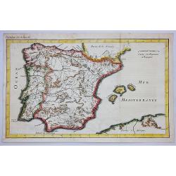
Carte du Royaume d'Espagne.
A striking map of Spain and Portugal. It is from METHODE POUR ETUDIER L’HISTOIRE by L’Abbe Lenglet du Fresnoy, published in Paris in 1729. The map is quite rare and i...
Date: Paris, 1729
Selling price: ????
Please login to see price!
Sold in 2020
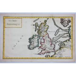
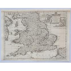
Les Iles Britanniques.
A striking map of the British Isles. It is from METHODE POUR ETUDIER L’HISTOIRE by L’Abbe Lenglet du Fresnoy, published in Paris in 1729. The map is quite rare. It wa...
Date: Paris, 1729
Selling price: ????
Please login to see price!
Sold in 2021
Carte du Premier Age, ou Situation du Paradis Terrestre.
A striking map of the ancient Middle East. It is from METHODE POUR ETUDIER L’HISTOIRE by L’Abbe Lenglet du Fresnoy, published in Paris in 1729. The map is quite rare ...
Date: Paris, 1729
Selling price: ????
Please login to see price!
Sold in 2017
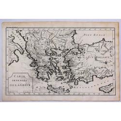
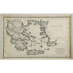
Carte Generale de la Grece.
A striking map of Greece. It is from METHODE POUR ETUDIER L’HISTOIRE by L’Abbe Lenglet du Fresnoy, published in Paris in 1729. The map is quite rare and is not now, n...
Date: Paris, 1729
Selling price: ????
Please login to see price!
Sold in 2017
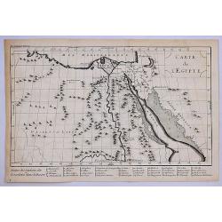
Carte Generale de L'Egypte.
A striking map of Egypt. It is from METHODE POUR ETUDIER L’HISTOIRE by L’Abbe Lenglet du Fresnoy, published in Paris in 1729. The map is quite rare and is not now, no...
Date: Paris, 1729
Selling price: ????
Please login to see price!
Sold in 2020
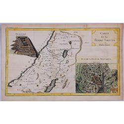
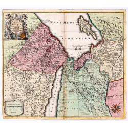
Carte de la Terre Sainte ou Palestine.
A striking map of the Holy Land (Palestine). It is from "METHODE POUR ETUDIER L’HISTOIRE" by L’Abbe Lenglet du Fresnoy, published in Paris in 1729. The map ...
Date: Paris, 1729
Selling price: ????
Please login to see price!
Sold in 2020
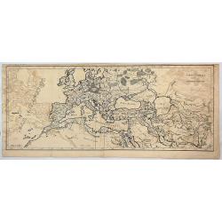
Carte Generale de L'Empire Romain.
A striking map of the Roman Empire. It is from the "METHODE POUR ETUDIER L’HISTOIRE" by L’Abbe Lenglet du Fresnoy, published in Paris in 1729. The map is qu...
Date: Paris, 1729
Selling price: ????
Please login to see price!
Sold in 2017
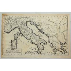
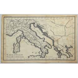
Carte D'Italie pour L'Histoire Moderne.
A striking map of Italy and European Turkey from the “METHODE POUR ETUDIER L’HISTOIRE” by L’Abbe Lenglet du Fresnoy, published in Paris in 1729. The map is quite ...
Date: Paris, 1729
Selling price: ????
Please login to see price!
Sold in 2019
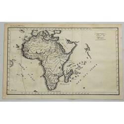
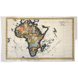
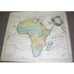
Carte De L'Africa.
A striking map of Africa with Madagascar from the “METHODE POUR ETUDIER L’HISTOIRE” by L’Abbe Lenglet du Fresnoy, published in Paris in 1729. The map is quite rar...
Date: Paris, 1729
Selling price: ????
Please login to see price!
Sold in 2018
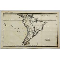
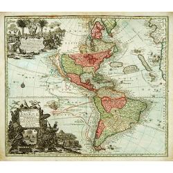
Amerique Meridionale.
A striking map of South America from the “METHODE POUR ETUDIER L’HISTOIRE” by L’Abbe Lenglet du Fresnoy, published in Paris in 1729. The map is quite rare, and is...
Date: Paris, 1729
Selling price: ????
Please login to see price!
Sold in 2020
Carte de la Grece pour L'intelleigence de la Guerre de Troye.
A striking map of Greece shown at the time of the war of Troy from the “METHODE POUR ETUDIER L’HISTOIRE” by L’Abbe Lenglet du Fresnoy, published in Paris in 1729....
Date: Paris, 1729
Selling price: ????
Please login to see price!
Sold in 2020
Carte D'Italie Pour L'Histoire Romaine.
A striking map of Italy shown at the time of the Romans from the “METHODE POUR ETUDIER L’HISTOIRE” by L’Abbe Lenglet du Fresnoy, published in Paris in 1729. The m...
Date: Paris, 1729
Selling price: ????
Please login to see price!
Sold in 2023
America aucta delineatio.
A very decorative map from a rare atlas by A.F. Zurner. The map shows a very unusual shape of California (depicted as an island) and the marvelous "Terra Iesso"...
Date: Nuremberg, 1729
Selling price: ????
Please login to see price!
Sold in 2018
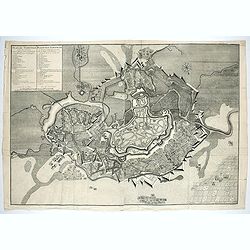
![Troisieme plan de la ville de Paris, son étendiie et les bourgs dont elle êtoit environnée sous le regne de Loüis le Jeune, VIIe du nom [...] par M.L.C.D.L.M.](/uploads/cache/42142-250x250.jpg)
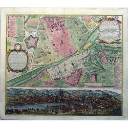
Troisieme plan de la ville de Paris, son étendiie et les bourgs dont elle êtoit environnée sous le regne de Loüis le Jeune, VIIe du nom [...] par M.L.C.D.L.M.
Engraved plan of Paris, oriented to the North with a compass rose (upper part) and equipped with a double scale (400 geometrical steps and 1000 not common) with a brief c...
Date: Paris, 1729
Selling price: ????
Please login to see price!
Sold
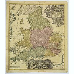
L'Angleterre Suivant les Nouvelles Observations. . .
An attractive map of England and Wales, showing part of the French coast and a small part of Scotland and Ireland, it has a decorative cartouche with scenes of English tr...
Date: Leiden, 1729
Selling price: ????
Please login to see price!
Sold in 2023
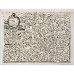
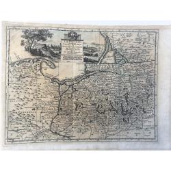
Carte du Gouvernement de Champagne Suivant le Nouvelles Observations . . .
An attractive map of the wine growing region of Champagne in France. It has a decorative cartouche with scenes of trading, country and coastal life. By Van Der AA in Leid...
Date: Leiden, 1729
Selling price: ????
Please login to see price!
Sold in 2020
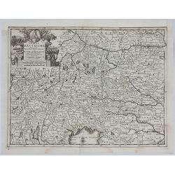
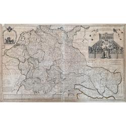
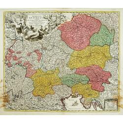
Cercle D'Autriche suivant les Nouvelles Observations.
An attractive, detailed map of Austria, part of Italy and the Czech Republic. Features a decorative cartouche with arms and a native holding a spear. Also portrait of a p...
Date: Amsterdam, 1729
Selling price: ????
Please login to see price!
Sold in 2021
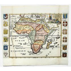
L' AFRIQUE. Selon les Autheurs les plus Modernes.
A beautiful map of Africa with african kingdom's emblems on the sides. Published by Jeanne de la Feuille in Amsterdam. Published in; "les tablettes Guerrieres ou Car...
Date: Amsterdam, 1729
Selling price: ????
Please login to see price!
Sold in 2019
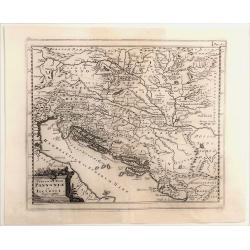
Veteris et Nova Pannonia et Illyrici.
Engraved map of the Dalmatian coast from Italy to Greece. From "Introductionis in Universam Geographiam". Embellished with a decorative title cartouche. Phili...
Date: Amsterdam, 1729
Selling price: ????
Please login to see price!
Sold in 2021
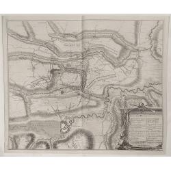
Plan der Veldslag van Oudernaerde den 11 July, 1708 ...
Fine detailed plan of the fortifications of Oudenaarde in Belgium by Dumont in 1729. Engraved by James Basire. Features a striking title cartouche with weapons. James...
Date: Paris, 1729
Selling price: ????
Please login to see price!
Sold in 2023
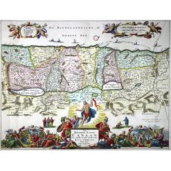
Het Beloofde Landt Canaan door wandelt van onsen Salichmaecker Iesu Christo, neffens syne Apostelen.
A beautifully engraved map of the ancient land of Canaan which roughly corresponds to present-day Israel. Cherubs hold up a draped cloth of key symbols, also a scale pane...
Date: Amsterdam, Pieter and Jacob Keur, 1729
Selling price: ????
Please login to see price!
Sold in 2020
Carte de l'Afrique.
A striking map of Africa with Madagascar from the “METHODE POUR ETUDIER L’HISTOIRE” by L’Abbe Lenglet du Fresnoy, published in Paris in 1729. The map is quite rar...
Date: Paris, 1729
Selling price: ????
Please login to see price!
Sold in 2020
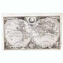
Orbis Terrarum Nova et accuratissima tabula.
Double-hemisphere copper engraved map of the world. Shows California as an island, large "Compagnies Land" between the Asian and American continents, and unfini...
Date: Leiden, 1729
Selling price: ????
Please login to see price!
Sold in 2020
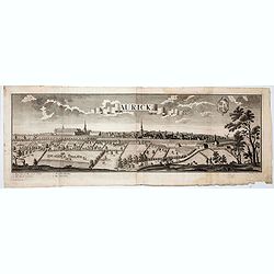
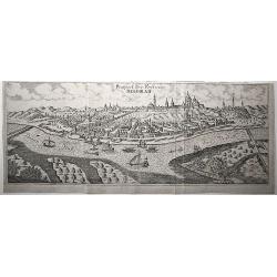
Aurick (Aurich)
A spectacular panoramic view of Aurich in the East Frisian region of Lower Saxony, with legends numbered 1-4 in German. With the title in a banderol.After a design by Fri...
Date: Augsburg, 1729
Selling price: ????
Please login to see price!
Sold in 2020
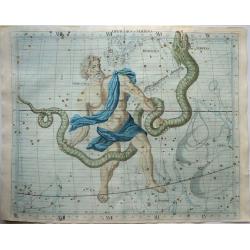
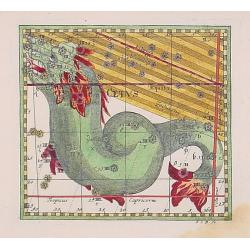
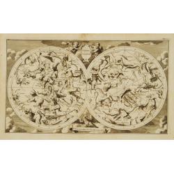
OPHIUCHUS & SERPENS.
A rare and large celestial chart by John Flamsteed (1646-1719) published in his 'Atlas Coelestis'. The atlas was published after his death and accompanied his catalogue o...
Date: LONDON, 1729
Selling price: ????
Please login to see price!
Sold in 2021
Plan de Temiswar … Plan van Temiswar.
Title also in Dutch: "Plan der Roemrugtige Veldslag Voorgevallen den 16 Augustus 1717 Digt by Belgrade ". Oriented to the southeast. Page placement in lower rig...
Date: The Hague, 1729
Selling price: ????
Please login to see price!
Sold in 2022
La Prusse. Suivant les Nouvelles Observations de Messrs. de l'Academie Royale des Sciences, etc. Augmentées de Nouveau. A Leide, chez Pierre vander Aa. - Avec Privilege.'
Decorative example of Van der Aa's map of Prussia, including Poland and Lithuania.
Date: Leiden, 1729
Selling price: ????
Please login to see price!
Sold in 2023
Magnae Britanniae. . . Regnum Angliae. . .
Johann Baptist Homann's well-engraved map of England and Wales has a large decorative cartouche at top right and a scrolled scene at bottom centre showing the King, (pres...
Date: Nurnberg, 1730
Selling price: ????
Please login to see price!
Sold in 2020
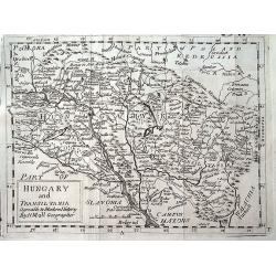
Hungary and Transilvania agreable to Modern History by H. Moll Geographer.
A scarce variant of Moll's map of Hungary and Transylvania, extending from Vienna to Belgrade.
Date: London, ca 1730
Selling price: ????
Please login to see price!
Sold in 2019
Perigrinatie ofte Veertich-Iarige Reyse Der Kinderen Israels uyt Egypten, door de Roode-Zee, ende de Woestyne,Tot in't Beloofde Landt Canaan.
Finely engraved and detailed. Showing the dispersion of the tribes of Israel. With an inset showing the actual lay out of the camp of the Israelis According to the law of...
Date: Dordrecht, 1730
Selling price: ????
Please login to see price!
Sold in 2020
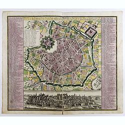
Milano, la Citta Principale et Fortezza Reale del Ducato medsino in Italia . . .
Fine example of Seutter's decorative and highly detailed plan of Milan, with a striking panoramic view of the City below. Matthaus Seutter the elder first published his &...
Date: Augsburg, 1730
Selling price: ????
Please login to see price!
Sold in 2023
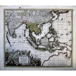
India Orientalis cum Adjacentibus Insulis Nova. . .
A superlative example of Seutter's scarce map of the East Indies showing part of Australia, from the famous "Atlas Novus". The map covers a large region extendi...
Date: Augsberg, 1730
Selling price: ????
Please login to see price!
Sold in 2020
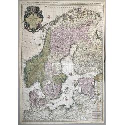
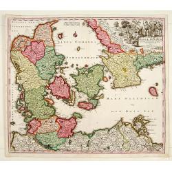
Carte des Couronnes du Nord qui Comprend les Royaumes de Danemark, Suede & Norwege.
A large format, highly detailed two sheet map of Scandinavia and the Baltic States. A beautifully engraved map with a highly decorative cartouche and two compass roses. S...
Date: Amsterdam, 1730
Selling price: ????
Please login to see price!
Sold in 2020
Prospect der Vestung Belgrad.
An exceptionally rare, unrecorded view of Belgrade, published around 1730.
Date: Unknown, ca. 1730
Selling price: ????
Please login to see price!
Sold in 2020
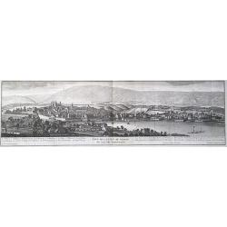
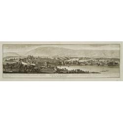
Veue de la ville de Geneve du coté du Septentrion.
A panoramic view of the city center of Geneva, Switzerland, as seen from Eaux Vives, Frontenex. The Jura mountains are in the background. After a design by Antoine Chopy ...
Date: Geneva, 1730
Selling price: ????
Please login to see price!
Sold in 2023
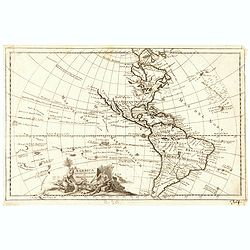
America Septentrionalis et Meridionalis Nova.
Map of the American continent. Including the voyages of Columbus, Magellan, Le Mair, Schouten, Dampier, van Noordt.
Date: Leiden, ca. 1730
Selling price: ????
Please login to see price!
Sold in 2021
![Atlas Methodicus Explorandis Juvenum... [Uncut Printing House Sheet]](/uploads/cache/84444-250x250.jpg)
Atlas Methodicus Explorandis Juvenum... [Uncut Printing House Sheet]
A large printing house leaf from Baptist Homann's work "Atlas Methodicus Explorandis Juvenum...", Nuremberg ca 1730. Including the title page and two maps.
Date: Nuremberg, ca. 1730
Selling price: ????
Please login to see price!
Sold in 2020
Deserta Aegypti Thebaidies Arabiae Syriae etc. ubi accurate notata sunt loca inhabitata per Sanctos Patres Anachoreatas.
Original engraved map of Egypt, Northern Arabia, the Holy Land, Syria and Cyprus, with original hand coloring. Verso blank. An attractive map of Egypt, northern Arabia, t...
Date: Augsburg, 1730
Selling price: ????
Please login to see price!
Sold in 2020
FLORENZ, FIRENZA la Capitale di Toscana etc. . .
A fine antique copper engraved map, a detailed plan with a fascinating panoramic view by Matthias Seutter, in Augsburg ca 1730. With two keys to the plan [numbers and let...
Date: Augsburg, ca 1730
Selling price: ????
Please login to see price!
Sold in 2020
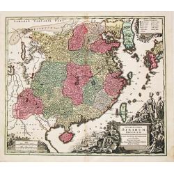
Opulentissimum Sinarum Imperium.
"Opulentissimum Sinarum Imperium". A highly decorative and strongly engraved map of China that includes the islands of Hainan and Formosa (Taiwan), the Korean p...
Date: Nuernberg, ca 1730
Selling price: ????
Please login to see price!
Sold in 2021
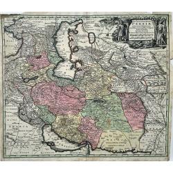
Opulentissimi Regni Persiae Juxta suas Provincias Recentissima et Accuratissima Designatio, Studio et Sumtibus.
A very decorative map of the Persian region and surroundings, from one of the most famous cartographers of the XVIII century. The map is centered on Persia, but it also s...
Date: Augsburg, 1730
Selling price: ????
Please login to see price!
Sold in 2022
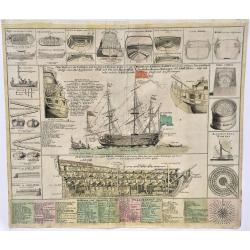
Neue Tafel, vor alle Liebhabers, und See-fahrende Personen. Stellet vor ein Orlog oder Kriegs=Schiff, mit seinen Völligen Tow oder Seil Werk auch Vor und Hindertheil
Extremely decorative, large print showing the details of war ships of the time. Note the nice original colors.
Date: Nurenberg, 1730
Selling price: ????
Please login to see price!
Sold in 2023
Eyland Man in St. Georges Channell
This is a scarce cartographic work by the Van Keulen family that provides three charts detailing islands in the Irish Sea.The chart at top left depicts the Isle of Man wi...
Date: Amsterdam, 1730
Selling price: ????
Please login to see price!
Sold in 2023
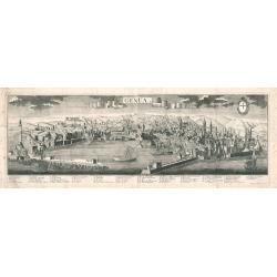
Genua
A panoramic bird's-eye-view of Genoa, Italy, printed on two sheets joined at the center. The work shows the harbor, city walls, buildings, churches, and hilly landscape i...
Date: Augsburg, 1730
Selling price: ????
Please login to see price!
Sold in 2023
A New Map of Germany, Hungary, Transilvania...
Large scale map of central Europe from Moll, published J. & T. Bowles, P. Overton & J. King. Shows the area within Danzig, Denmark, Paris, Venice, Trieste, Pragu...
Date: London, ca. 1730
Selling price: ????
Please login to see price!
Sold in 2023
Cutus.
Uncommon celestial print showing the constellation of Cetus, published by C.Thomas in the Mercurii philosophici firmamentum firmianum descriptionem et usum globi artifici...
Date: Frankfurt & Leipzig, c.1730
Selling price: ????
Please login to see price!
Sold
Daniae Regnum.
No text on verso.
Date: Nuremberg 1730
Selling price: ????
Please login to see price!
Sold
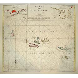
Carte des Isles d? Acores.
An uncommon and highly attractive map of the Azores. It contains much detail, with inset maps of Porto de Santa Cruz along with the town of Angra, located on the island o...
Date: Amsterdam, 1730
Selling price: ????
Please login to see price!
Sold
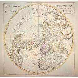
Hemisphere Septentrional pour voir plus.. les Terres..
The Covens & Mortier edition of this highly important map of the Northern Hemisphere. This work is the first to correctly place the west coast of North America by mov...
Date: Amsterdam, ca. 1730
Selling price: ????
Please login to see price!
Sold
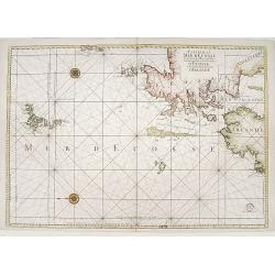
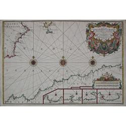
Carte de la mer d'Ecosse../d'Irlande
Sea chart depicting northern tip of Ireland and Scotland. East to top.
Date: Paris 1730
Selling price: ????
Please login to see price!
Sold
" LE ROYAUME DE France Divisé en Toutes ses Provinces et ses acquisitions."
An Amsterdam version of the general map of France by Hubert Jaillot. The scale cartouche upper left has the name of the publisher : P.Mortier et Compagnie.
Date: Amsterdam, ca. 1730
Selling price: ????
Please login to see price!
Sold in 2009
Novus Orbis sive America Meridionalis et Septentrionalis..
A finely engraved and decorative mid-18th century map published in Augsburg, Germany. This map shows the state of early exploration with some of the explorer's routes in ...
Date: Augsburg c. 1730
Selling price: ????
Please login to see price!
Sold
Germania Austriaca.
Decorative and detailed map showing northern part of Italy including Milan, Mantua, Venice. Also showing today's Czech Republic, Slovakia, Hungary, Bavaria (in Germany), ...
Date: Nuremberg 1730
Selling price: ????
Please login to see price!
Sold
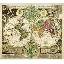
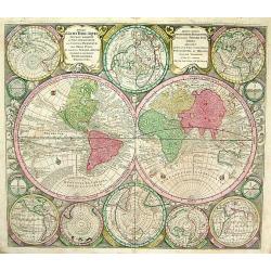
Planiglobii Terrestris Cum Utroq Hemisphaerio..
Vibrantly decorative world map surrounded by vivid engravings of natural phenomena such as waterspouts, a rainbow, earthquakes, and a volcano. Wind heads occupy the starr...
Date: Germany 1730
Selling price: ????
Please login to see price!
Sold
Suite des Costes d?Espagne et Barbarie.
A chart showing the coast of Spain from Cartagena to Denia with Ibiza and Formentera and the coast of North Africa With 4 insets with coastal details and decorated with t...
Date: Paris, 1727-1730
Selling price: ????
Please login to see price!
Sold
Accurata delineatio....Gallice Louisiane ol. Cauad' et Floridae
Full title: Accurata delineatio celeberrimae Regionis Ludovicianae vel Gallice Louisiane ol. Cauad' et Floridae adpellatione in Septemtrionali America. A beautiful map of...
Date: Germany, 1730
Selling price: ????
Please login to see price!
Sold
Diversi Globi Terr-Aquei, Statione Variante et Visu Intercendente,
Title: Diversi Globi Terr-Aquei, Statione Variante et Visu Intercendente, per Coluros Tropicorum, per Ambos Polos, et Particul. Sphaerae Zenith in Planum Delineati Orthog...
Date: Germany, c 1730
Selling price: ????
Please login to see price!
Sold

Discours sur l'histoire universelle..
Three volumes with 26 maps, including the World and Continents, Israel, Middle sea area, Russia, Scandinavia,Denmark, Iceland,Poland, Britain, England, Scotland,Ireland,N...
Date: Amsterdam, 1730
Selling price: ????
Please login to see price!
Sold
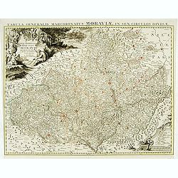
Carte générale du marquisat de Moravie..
Very detailed map of Moravia.
Date: Amsterdam, 1730
Selling price: ????
Please login to see price!
Sold
L'Afrique Dressee sur les Observations de Ms. de l'Academie Royale des Sciences?.
Guillaume de l'Isle's (1675-1726) well deserved reputation as one of the foremost geographers of the 18th century meant that his maps were influential for many years afte...
Date: Amsterdam ca. 1730
Selling price: ????
Please login to see price!
Sold
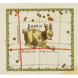
Lepus.
Uncommon celestial print of Lepus, published by C.Thomas in the Mercurii philosophici firmamentum firmianum descriptionem et usum globi artificialis coelestis. Individual...
Date: Frankfurt & Leipzig, c.1730
Selling price: ????
Please login to see price!
Sold
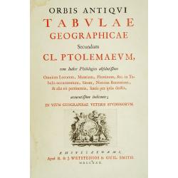
(Title page) Orbis Antiqui Tabulae Geographicae Secundum Cl. Ptolemaeum. . .
Decorative frontispiece printed in red and black letter press with in lower part a decorative copper engraving with putti holding a circle with the text Terrar dum Prosim...
Date: Amsterdam, 1730
Selling price: ????
Please login to see price!
Sold in 2016
MEYLAND. F. B. Werner delin. Haered. Ieremiae Wolff excud.
A spectacular panoramic view of Milan designed by Friedrich Bernhard Werner (1690-1776). With the title in a banderol at the head, flanked on the right by the crowned cit...
Date: Augsbourg , ca. 1730
Selling price: ????
Please login to see price!
Sold
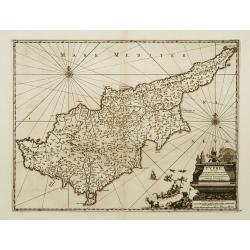
Cypre, île de la Méditerrannée.
This map by van der Aa copies the Cyprus map of Willem Blaeu . It is smaller in size and Blaeu's exquisite decorative treatment has been replaced by a cartouche and new p...
Date: Leiden 1730
Selling price: ????
Please login to see price!
Sold
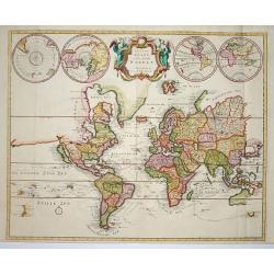
Platte Kaart van de geheele Werelt.
This scarce and unusual map of the world is derived from Pierre Mortier's Carte General du Monde of 1700. The map is on Mercator's projection and depicts California as an...
Date: Amsterdam 1730
Selling price: ????
Please login to see price!
Sold
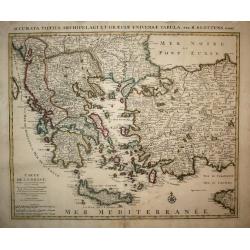
Carte de la Grece.
A striking, large map detailing Greece, the western part of Turkey and extending to show Albania, Macedonia and part of Cyprus. Latin title at top "Accurata Totius A...
Date: Amsterdam, 1730
Selling price: ????
Please login to see price!
Sold in 2008
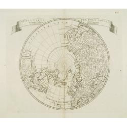
Nuova carta del Polo Artico secondo l'ultime osservazioni ..
From an Italian edition of Solmons work of this attractive map of a north polar projection. CALIFORNIA IS SHOWN AS AN ISLAND and the Pacific region is completely blank. G...
Date: Rome 1730
Selling price: ????
Please login to see price!
Sold
Vue de la ville de Geneve du coté du septentrion.
Decorative panoramic view of Geneva, after Robertus Gardelle and engraved by J.G.Seiller. From Jacob Spon Histoire de Genève. Rectifiée & augmentée par d'amples no...
Date: Geneva, Fabri & Barrillot, 1730
Selling price: ????
Please login to see price!
Sold

Veuë de la ville de Geneve du coté du midy.
Decorative panoramic view of Geneva, after Robertus Gardelle and engraved by Daudet. From Jacob Spon Histoire de Genève. Rectifiée & augmentée par d'amples notes..
Date: Geneva, Fabri & Barrillot, 1730
Selling price: ????
Please login to see price!
Sold
Globe Celeste. Coeli Enarrant Gloriam Del.
Charming double hemisphere celestial map on a polar projection. The map depicts the ecliptic pole to ecliptic, joined through winter solstice. It is based on the Hondius ...
Date: Amsterdam 1730
Selling price: ????
Please login to see price!
Sold
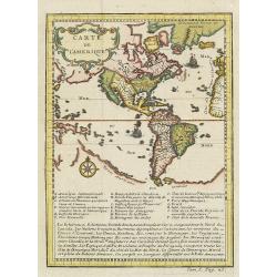
Carte de l'Amerique.
A very nice map centered on the American continent. Title cartouche on the upper left-hand corner. Includes also a lettered key legend on the lower part of the map.
Date: Paris, ca. 1730
Selling price: ????
Please login to see price!
Sold in 2017