Please login to see price!.
Subscribe to be notified if similar examples become available.
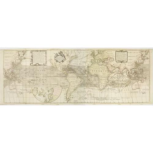
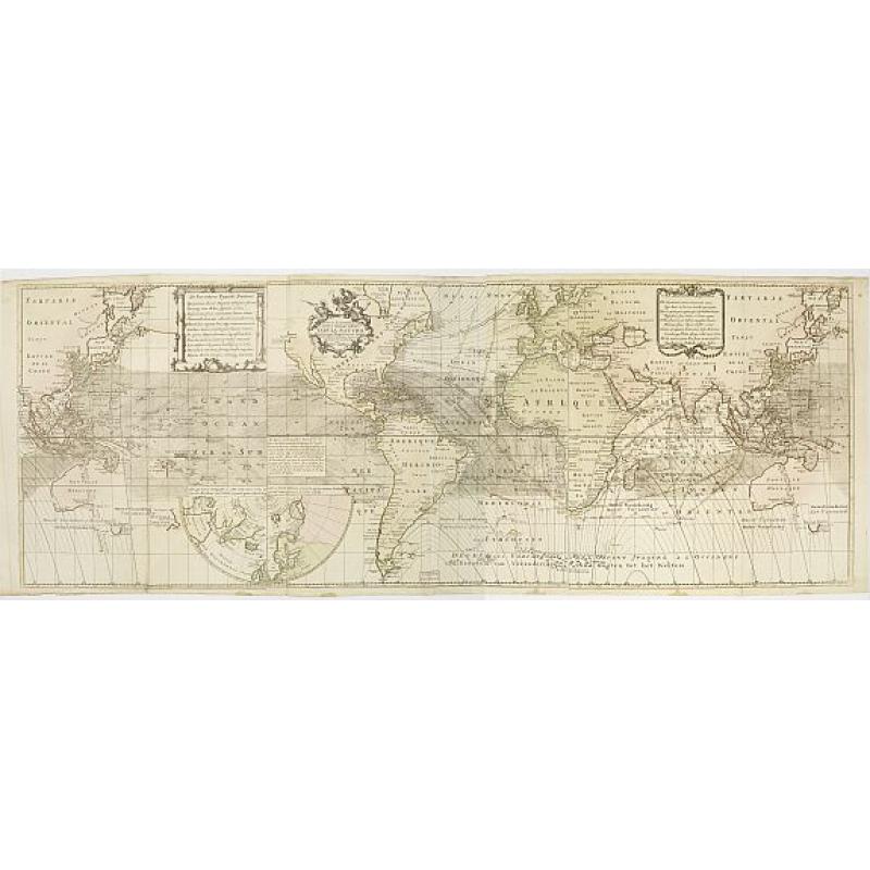
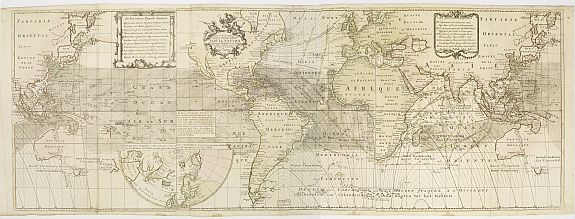
Nova & Accuratismia Totius Terrarum Tabula Nautica Variationum Magneticarum Index Juxta Obserations Anno 1706 habitas Constructa per Edm. Halley. |
||||||||||||||||||||
|
||||||||||||||||||||
|
|
||||||||||||||||||||
|
Selling price: $...
Please login to see price! Sold Missed this item! Be the first to get notified about our newly added listings. Add your name to our mailing list. Feel free to contact us if you have a question about this item. |
Virtual Collection - Save and collect this or any of your favorite items in one place.
If you want to save the items permanently, please sign in or create account first. |
|||||||||||||||||||
Description
Dutch publication of Halley's important chart demonstrating the variations of the compass, created by him in 1701. Though best known as the discoverer of the comet which bears his name, Halley was also an accomplished surveyor and cartographer, and in 1702 created a chart of Britain's coastlines, charting the tides. On the present map, California is shown as an island, Australia is only partially mapped, and New Zealand is not shown.
Second edition with wind directions added.
The eastern coast of Australia is not outlined as well as Polynesia.
The first world map to show isogonals, or lines showing equal magnetic variation in the oceans, a feature considered of paramount importance for the determination of longitude. Edmund Halley (1656-1742), second Astronomer Royal, referred to as the greatest of European astronomers, and next to Newton among the finest scientific Englishmen of his time, is best remembered for the comet that bears his name.
By the age of twenty, in 1676, his fame as a student of celestial phenomena was already so great that he was sent to the island of St. Helena to make the first scientific determinations of the positions of the stars in the Southern Hemisphere. Upon his return to England in 1678, Halley was elected a fellow of the Royal Society. In 1686, at his own expense, he published Newton's Principia, in which the Law of Gravity was first set forth. In 1703, Halley was appointed Professor of Geometry at Oxford and, in 1721, he was made Astronomer Royal at Greenwich, succeeding Flamsteed.
In 1698, in the hope that Halley might be able to solve the longitude problem, he was made a Captain of the Royal Navy and was sent to sea aboard the Paramour at the command of William III. His primary mission was to chart the variation of the Earth's magnetic field in the Western and Eastern hemispheres. He returned in 1700 and this map is the product of his measurements.
The lines on the chart, called isogonals, depict the declinations of the compass. This is the first map on which they appear. As Rodney Shirley notes, thus the isoline, or line of equal [magnetic] value was invented. For more than a century Halley's magnetic lines were a familiar feature of the world chart. As it turns out, however, the variations fluctuate with time and cannot be used to find longitude at sea. A complete set of 3 joined sheet, with to the left the third sheet who repeats the information in Asia and Oceana with a text block cartouche. Nice old color example.
An attractive example of this rare and highly sought after map.
Reference: Cumming, The Exploration of North America, pp. 22-23.
FAQ - Guarantee - Shipping
Buying in the BuyNow Gallery
This item is available for immediate purchase when a "Add to Cart" or "Inquire Now" button is shown.
Items are sold in the EU margin scheme
Payments are accepted in Euros or US Dollars.
Authenticity Guarantee
 We provide professional descriptions, condition report (based on 45 years experience in the map business)
Paulus Swaen warrants the authenticity of our items and a certificate of authenticity is provided for each acquired lot.
Condition and Coloring
We indicate the condition of each item and use our unnique HiBCoR grading system in which four key items determine a map's value: Historical Importance, Beauty, Condition/Coloring and Rarity.
Color Key
We offer many maps in their original black and white condition. We do not systematically color-up maps to make them more sellable to the general public or buyer.
Copper engraved or wood block maps are always hand colored. Maps were initially colored for aesthetic reasons and to improve readability. Nowadays, it is becoming a challenge to find maps in their original colors and are therefor more valuable.
We use the following color keys in our catalog:
Original colors; mean that the colors have been applied around the time the map was issued.
Original o/l colors; means the map has only the borders colored at the time of publication.
Colored; If the colors are applied recently or at the end of the 20th century.
Read more about coloring of maps [+]
Shipping fee
A flat shipping fee of $ 30 is added to each shipment by DHL within Europe and North America. This covers : International Priority shipping, Packing and Insurance (up to the invoice amount).
Shipments to Asia are $ 40 and rest of the world $50
We charge only one shipping fee when you have been successful on multiple items or when you want to combine gallery and auction purchases.
Read more about invoicing and shipping
FAQ
Please have a look for more information about buying in the BuyNow gallery
Many answers are likely to find in the general help section.
Virtual Collection
![]()
With Virtual Collection you can collect all your favorite items in one place. It is free, and anyone can create his or her Virtual map collection.
Unless you are logged in, the item is only saved for this session. You have to be registed and logged-in if you want to save this item permanently to your Virtual Collection.
Read More[+]
Register here, it is free and you do not need a credit card.
Add this item to
Virtual Collection
or click the following link to see my Virtual Collection.
| Digital Image Download | |
|
Paulus Swaen maintains an archive of most of our high-resolution rare maps, prints, posters and medieval manuscript scans. We make them freely available for download and study. Read more about free image download |
Click the image for a free small image download. |
In accordance with the EU Consumer Rights Directive and habitually reside in the European Union you have the right to cancel the contract for the purchase of a lot, without giving any reason.
The cancellation period will expire 14 calendar days from the day after the date on which you or a third party (other than the carrier and indicated by you) acquires, physical possession of the lot. To exercise the right to cancel you must inform Paulus Swaen Inc, of your decision to cancel this contract by a clear statement (e.g. a letter sent by post, or e-mail (amsterdam@swaen.com).
To meet the cancellation deadline, it is sufficient for you to send your communication concerning your exercise of the right to cancel before the cancellation period has expired.
