Browse Listings
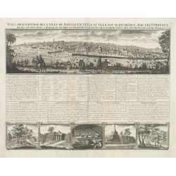
Vue & discription de la Ville de Jerusalem.. Avec Tombeaux..
This copper-engraving shows a panoramic view of Jerusalem, two insets of mount "Liban" and three insets of the tombs De Zacharie, Des Rois, and D'Absalom.Zachar...
Date: Amsterdam, 1728
Selling price: ????
Please login to see price!
Sold in 2010
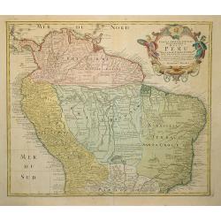
Tabula Americae Specialis Geographica Regni Peru . . .
A good and clean copy of Homann's map of the northern part of South America. Imposing title cartouche.
Date: Nuremberg 1728
Selling price: ????
Please login to see price!
Sold in 2011
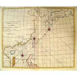
A Chart of the Coast of China.
Rare English chart of the China coast and seas by famed astronomer and comet tracker Edmond Halley. This chart comes from Halley's rare Atlas Maritimus et Commercialis. D...
Date: London, 1728
Selling price: ????
Please login to see price!
Sold in 2009
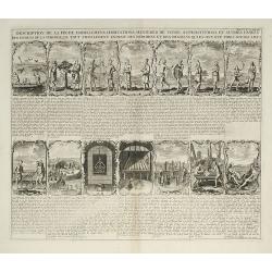
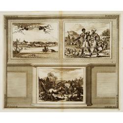
Description de la peche, habillemens ?
This sheet contains fourteen vignettes of the Virginia colony after De Bry's engravings of John White's drawings. 130 years later he chose these illustrations because the...
Date: Amsterdam, 1728
Selling price: ????
Please login to see price!
Sold in 2009
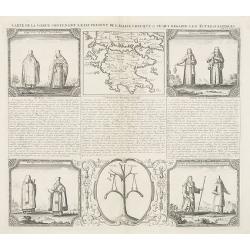
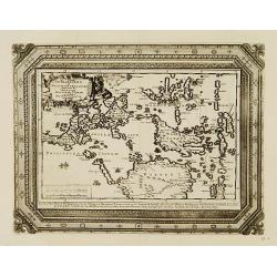
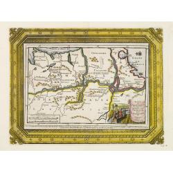
Carte de la Grece contenant l'Etat present de l'Eglise Grecque &..
Handsome chart with a small map of Greece (115 x 150mm.) together with five Greek religious scenes and descriptive French text.
Date: Amsterdam, 1728
Selling price: ????
Please login to see price!
Sold in 2010
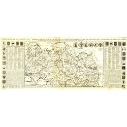
Carte générale des états du Czar Empereur de Moscovie, ou l'on voit ce que ce prince posséde en Europe et les états qu'il posséde en Asie.
General map of Russia of the states of the Czar Emperor of Muscovy showing his possessions in Europe and Asia. To the left and right explanatory panels with coats of arms...
Date: Amsterdam, 1728
Selling price: ????
Please login to see price!
Sold in 2011
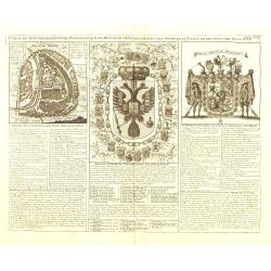
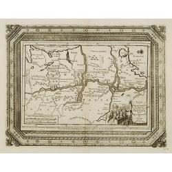
Carte du Gouvernement Civil et Ecclesiastique de Moscovie, l'Etat des Revenus et l'Ordre de la Justice et des Officiers
Very fine engraved text sheet with a small (5.5 x 5.5"), detailed plan of Moscow, plus two large coats-of-arms. Descriptive French text below, size is for the overal...
Date: Amsterdam, ca. 1728
Selling price: ????
Please login to see price!
Sold in 2010
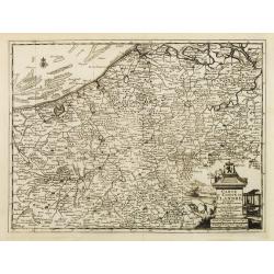
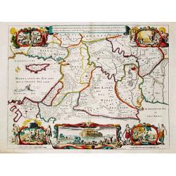
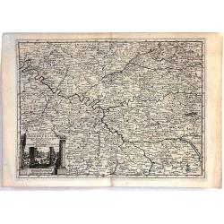
Carte du Comté de Flandre, suivant les nouvelles observations. . .
Including Flanders and part of Brabant. With decorative title cartouche lower right corner with coat of arms, a farmer and a person weaving textiles.
Date: Amsterdam, 1728
Selling price: ????
Please login to see price!
Sold in 2022

Grande Pologne et Prusse avec les frontières de la Misnie, Lusace, Moravie et Lithuanie.
Detailed map of Poland and Prussia. Published by Pieter van der Aa who published a.o. "Naauwkeurge versameling der gedenkwaardigste zee- en land-reysen", a seri...
Date: Leiden, 1729
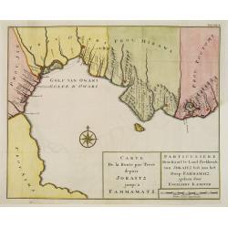
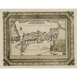
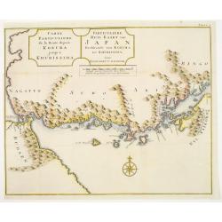
Carte de la route par terre depuis Jokaitz jusqu'à Fammamatz.
Detailed and attractive map from his important and comprehensive work. The land route from Yokkaichi to Hammamatsu. Kaempfer's greatest cartographic achievement was his r...
Date: The Hague, 1729
Selling price: ????
Please login to see price!
Sold in 2011
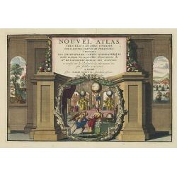
Nouvel Atlas.. (Title page)
A fine detailed title page with charming pictorial scenes showing globes, a map, cross-staff, compass, Atlas-figure and a western and oriental landscape.Very attractive p...
Date: Leiden, 1729
Selling price: ????
Please login to see price!
Sold in 2013
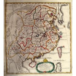
Paradigma XV Provinciarum et CLV Urbium Capitalium Sinensis Imperij Cum Templis...
Rare map of China from Stocklein's "Neuer Welt Bolt", a German translation of the Jesuit Lettres Edifiantes. Based on Philippe Couplet's map of 1686, the map sh...
Date: Augsburg, 1729
Selling price: ????
Please login to see price!
Sold in 2010
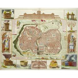
Ierusalem
Great bird's eye plan of the holy city flanked by engravings of religious icons, and two priests. At the top is a large elevation of the Temple of Solomon and at bottom i...
Date: Amsterdam 1729
Selling price: ????
Please login to see price!
Sold
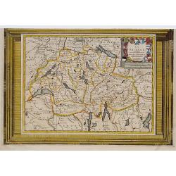
La Suisse. Suivant les nouvelles observations..
Decorative map, due to its fine border. The map itself is printed within a decorative border, printed from a different plate.
Date: Amsterdam 1729
Selling price: ????
Please login to see price!
Sold
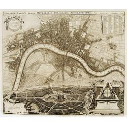
Londini Angliae regni metropolis delineatio accuratissima ..
A beautifully engraved and richly detailed plan of London. In upper right part a key to 148 principal spots in the town. From Galerie Agréable du Monde, a sixty-six volu...
Date: Leiden 1729
Selling price: ????
Please login to see price!
Sold
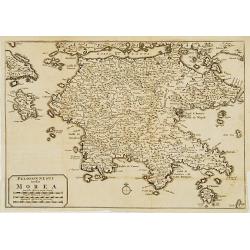
Peloponnesus hodie Morea.
Decorative regional map of Morea and contiguous islands.
Date: Leiden 1729
Selling price: ????
Please login to see price!
Sold
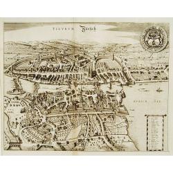
Tigurum Zürüch.
A beautifully engraved and richly detailed plan of Zürich. In upper right part a key to 27 principal spots in the town. Originally engraved for the rare town book of Fre...
Date: Leiden 1729
Selling price: ????
Please login to see price!
Sold

Basilea Basel.
A beautifully engraved and richly detailed plan of Basel. In upper right part a key to 42 principal spots in the town. Originally engraved for the rare town book of Frede...
Date: Leiden 1729
Selling price: ????
Please login to see price!
Sold
De Manilles of Philippines Eylanden benevens de Moluccos, Macassar, Tymor en andere door P.W.Verhoeve aangedaan.
A beautifully engraved map of the area around the Philippines. Showing the track of the voyage by Pieter Willem Verhoeve.From Galerie Agréable du Monde, a sixty-six volu...
Date: Leiden 1729
Selling price: ????
Please login to see price!
Sold
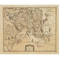
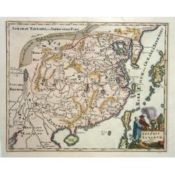
Nouvelle Carte de L'Asie.
An uncommon and beautifully engraved map of Asia, including Australia. In the upper right corner, north of Japan Companies Land.From Galerie Agréable du Monde, a sixty-s...
Date: Leiden 1729
Selling price: ????
Please login to see price!
Sold
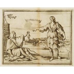
William Adams Reystogt na Oost-Indien.. JAPAN..
Map of Japan and Korea. In lower right a fine title cartouche showing William Adams during an audience with the shogun, who sits under a baldachin on a fancifully portray...
Date: Leiden 1729
Selling price: ????
Please login to see price!
Sold
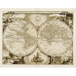
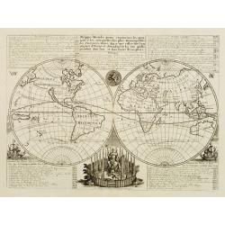
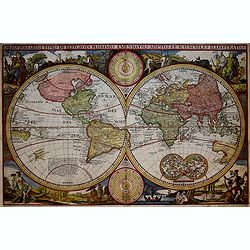
Nouvelle Mappe-Monde..
Attractively engraved double-hemisphere world map with rich surrounding decoration based on the four seasons. Showing California as an island.From Galerie Agréable du Mo...
Date: Amsterdam 1729
Selling price: ????
Please login to see price!
Sold
Novum Amsterodamum..
A good example of one of the earliest available views of New York. Set in a border with two other prints. To the right a couple from the New England area. In the bottom a...
Date: Leiden 1729
Selling price: ????
Please login to see price!
Sold
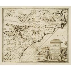
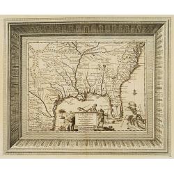
Partie Meridionale de la Virginie et la .. Floride dans L'Amerique septentrionale ..
A scarce and attractive map of the American colonies stretching from Chesapeake Bay through the Carolinas.Geographically based on the Montanus map, which was in turn base...
Date: Amsterdam 1729
Selling price: ????
Please login to see price!
Sold
Nieu Amsterdam al. New York.
Originally engraved by Carolus Allard's for his Orbis Habitablis the print shows two locals and a distance view of lower Manhattan.From Galerie Agréable du Monde, a sixt...
Date: Leiden 1729
Selling price: ????
Please login to see price!
Sold
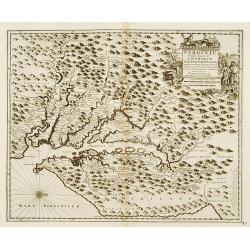
Partie Meridionale de la Virginie et la .. Floride dans L'Amerique septentrionale ..
Pierre van der AA used the old copper plate of Meurs and re-did the engraving, changed the large pictorial cartouche, a new scale of German and French leagues is provided...
Date: Amsterdam 1729
Selling price: ????
Please login to see price!
Sold
Land en volk-ondekking in't noorder gedeelte van America door P.Marquette en Joliet.
Interesting map of the Mississippi delta. East to the top. According to the title the information is after P.Marquette and Joliet.This example is unusual in having the ad...
Date: Amsterdam 1729
Selling price: ????
Please login to see price!
Sold
La Floride, suivant les nouvelles observations?
This splendid map of the southern United States was based on Delisle's influential Carte du Mexique de la Floride.. of 1703. The map is filled with details of early colon...
Date: Amsterdam 1729
Selling price: ????
Please login to see price!
Sold

L'Amerique Septentrionale suivant les nouvelles observations ..
Splendid map of North America.These separately engraved border frames appear much more uncommon than the standard edition without border frames. From Galerie Agréable du...
Date: Amsterdam 1729
Selling price: ????
Please login to see price!
Sold
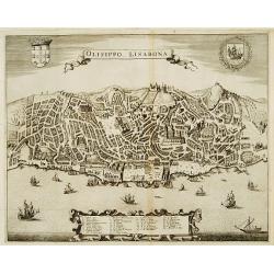
Olisippo. Lisabona.
A beautifully engraved and richly detailed plan of Lisbon. In bottom part a key to 34 principal spots in the town. Originally engraved for the rare town book of Frederick...
Date: Leiden 1729
Selling price: ????
Please login to see price!
Sold
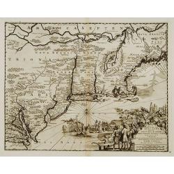
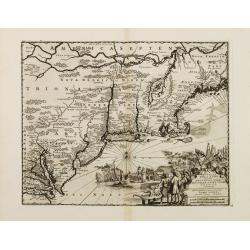
Nouvelle Hollande (a present NOUVELLE-YORK)..
A charming map from the famous Jansson-Visscher series of maps covering the east coast from the Chesapeake Bay to Maine. The map has a particularly large title piece show...
Date: Leiden 1729
Selling price: ????
Please login to see price!
Sold
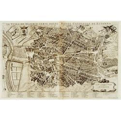
La villa de Madrid corte delos reyes catolicos de Espagne.
A beautifully engraved and richly detailed plan of Madrid. In bottom part a key to 67 principal spots in the town. Originally engraved for the rare town book of Frederick...
Date: Leiden 1729
Selling price: ????
Please login to see price!
Sold
![[Title page] La galerie agréable du Monde.](/uploads/cache/17243-250x250.jpg)
[Title page] La galerie agréable du Monde.
Title page from van der Aa's very rare work La galerie agreable du Monde. A fine detailed title page with in lower part a charming pictorial scene showing classical figur...
Date: Leiden 1729
Selling price: ????
Please login to see price!
Sold
Novum Amsterodamum..
A good example of one of the earliest available views of New York. Set in a border with two other prints. To the right a couple from the New England area. In the bottom a...
Date: Leiden 1729
Selling price: ????
Please login to see price!
Sold
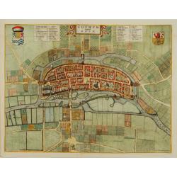
Goghum. Vernavule Goch.
A beautifully engraved and richly detailed plan of Gogh. In upper part a numbered key (1-42). From Galerie Agréable du Monde, a sixty-six volume atlas complied in 1729 a...
Date: Leiden 1729
Selling price: ????
Please login to see price!
Sold
Imperii Sinarum
Map with a fair number of provinces & cities in the interior. The Great Wall is depicted along the northern border. A large fictitious interior lake labeled Kia Lacus...
Date: Amsterdam 1729
Selling price: ????
Please login to see price!
Sold
![[Arcadian Landscape]](/uploads/cache/21573-250x250.jpg)
[Arcadian Landscape]
Engraving of an Arcadian Landscape,building and a river in the background, figures on the foreground. Engraved by P.Rysbrack, pinxit, fecit et excudit
Date: Flanders 1655-1729
Selling price: ????
Please login to see price!
Sold
Land en volk-ondekking in't noorder gedeelte van America door P.Marquette en Joliet.
Interesting map of the Mississippi delta. East to the top. According to the title the information is after P.Marquette and Joliet.This example is unusual in having the ad...
Date: Amsterdam 1729
Selling price: ????
Please login to see price!
Sold
Carte de la route depuis Nagasaki jusqu' à Kokura.
Detailed and attractive map from his important and comprehensive work. The east-oriented route map from Nagasaki to Kokura.Kaempfer's greatest cartographic achievement wa...
Date: The Hague 1729
Selling price: ????
Please login to see price!
Sold
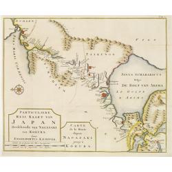
Carte de la route depuis Kokura jusqu' à Khurissima.
Detailed and attractive map from his important and comprehensive work. The route from Kokura to Kurishima.Kaempfer's greatest cartographic achievement was his route maps ...
Date: The Hague 1729
Selling price: ????
Please login to see price!
Sold
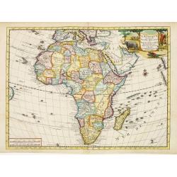
L'Afrique.
An attractive map. The large cartouche is decorated by scenes of ostrich and crocodile hunting and elephants.
Date: Leiden 1729
Selling price: ????
Please login to see price!
Sold
Nouvelle Hollande (a present NOUVELLE-YORK)..
A charming map from the famous Jansson-Visscher series of maps covering the east coast from the Chesapeake Bay to Maine. The map has a particularly large title piece show...
Date: Leiden 1729
Selling price: ????
Please login to see price!
Sold
Mappe-Monde pour connoitre les progres & les conquestes..
Unusual double hemisphere map with California as an Island. Dutch text describes the expeditions and colonial possessions of the Dutch East India Company.The map originat...
Date: Amsterdam, 1729
Selling price: ????
Please login to see price!
Sold
De Gelegentheyt van t' Paradys en t' Landt Canaan, mitsgaders d' eerst bewoonde Landen der Patriarchen.
Dutch so-called ' Staten' bibles, published between 1637 and c. 1760, contained 5 maps: The World, ' Paradise', The Perigrinations, The Promised Land Canaan, The Travels ...
Date: Amsterdam, Pieter en Jacob Keur, 1729
Selling price: ????
Please login to see price!
Sold

Africa vetus . . .
A rare issue of this map by Weigels, usually seen with a different cartouche showing disks (coins) instead of the one shown here. A person is skinning an ox on a rock, wh...
Date: Nurnberg, 1729
Selling price: ????
Please login to see price!
Sold in 2008
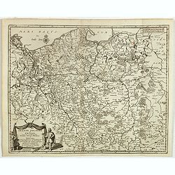
Veteris et Novae Regni Poloniae Magniq Ducatus Lithuaniae Cum Suis Palatinatibus ac Consinus Descriptio.
A simple map displays the region from the Baltic to the Black Sea, centered on Lithuania.It is filled with ancient place names. Presents a decorative title cartouche in t...
Date: Amsterdam, 1729
Selling price: ????
Please login to see price!
Sold in 2008

Mappe-Monde pour connoitre les progres & les conquestes..
Unusual double hemisphere map with California as an Island. Dutch text describes the expeditions and colonial possessions of the Dutch East India Company. The map origina...
Date: Amsterdam, 1729
Selling price: ????
Please login to see price!
Sold in 2008
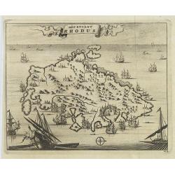
Het Eylant Rhodus.
An attractive bird's eye-view of the island of Rhodes. Pieter van der Aa was a prolific publisher. He published a.o. "Naaukeurige versameling der gedenkwaardigste ze...
Date: Leiden, 1729
Selling price: ????
Please login to see price!
Sold in 2009
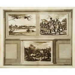
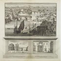
Prospectus Palatii Oratoris Hispaniarum, et fori Hispanici. . .
Three plates on one sheet. Upper one showing Piazza di Spagna in Rome. Pieter van der Aa was a prolific publisher. He published a.o. "Naaukeurige versameling der ged...
Date: Leiden, 1729
Selling price: ????
Please login to see price!
Sold in 2009
Prospectus pontiss Mariae . . .
Three plates on one sheet. Upper one showing a destroyed Santa Maria Bridge in Rome. Pieter van der Aa was a prolific publisher. He published a.o. "Naaukeurige versa...
Date: Leiden, 1729
Selling price: ????
Please login to see price!
Sold in 2009
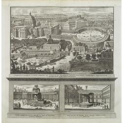
Conspectvs basilicae d. Petri, Porticvs . . .
Three plates on one sheet. Upper one showing St. Peter Basilica in Rome. Pieter van der Aa was a prolific publisher. He published a.o. "Naaukeurige versameling der g...
Date: Leiden, 1729
Selling price: ????
Please login to see price!
Sold in 2011
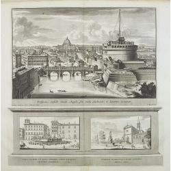
Prospectus Castelli Sancti Angeli . . .
Three plates on one sheet. Upper one showing Santa Maria degli Angeli and St. Peter Basilica in Rome. Pieter van der Aa was a prolific publisher. He published a.o. "...
Date: Leiden, 1729
Selling price: ????
Please login to see price!
Sold in 2009
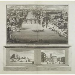
Prospectus Pontis Sixti in Locorvmq adjecentivm . . .
Three plates on one sheet. Upper one showing canal in Rome. Pieter van der Aa was a prolific publisher. He published a.o. "Naaukeurige versameling der gedenkwaardigs...
Date: Leiden, 1729
Selling price: ????
Please login to see price!
Sold in 2009
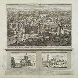
Prospectus Fori Romani. . .
Three plates on one sheet. Upper one showing Forum Romanum in Rome. Pieter van der Aa was a prolific publisher. He published a.o. "Naaukeurige versameling der gedenk...
Date: Leiden, 1729
Selling price: ????
Please login to see price!
Sold in 2009
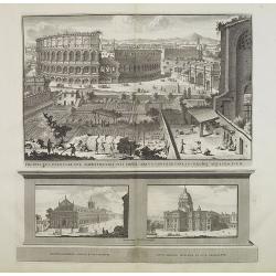
Prospectus Pontis Sixti in Locorvmq adjecentivm . . .
Three plates on one sheet. Upper one showing Coliseum in Rome, in lower part St. Peter's Basilica in the Vatican. Pieter van der Aa was a prolific publisher. He published...
Date: Leiden, 1729
Selling price: ????
Please login to see price!
Sold in 2009
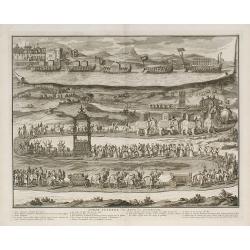
Pompe funèbre des rois de Tunquin.
Date: London, 1729
Selling price: ????
Please login to see price!
Sold in 2010
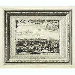
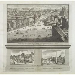
Constantinople Ville de la Turquie en Europe.
Beautiful view of Constantinople, from "La Galerie agreable du monde. . . divisée en LXVI tomes...Cette partie comprend le tome premiere d'Hongrie, Turquie en Europ...
Date: Leiden, 1729
Selling price: ????
Please login to see price!
Sold in 2011
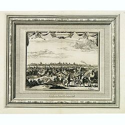
Constantinople Ville de la Turquie en Europe.
Beautiful view of Constantinople, from "La Galerie agreable du monde. . . divisée en LXVI tomes...Cette partie comprend le tome premiere d'Hongrie, Turquie en Europ...
Date: Leiden, 1729
Selling price: ????
Please login to see price!
Sold in 2014
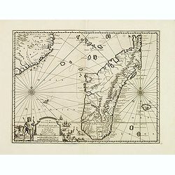
Ile de S. Laurens, ou Madagascar, située dans L'Ocean Ethiopien, sur les Côtes de L'Afrique.
Detailed map of Madagascar and Réunion. Published by Pieter van der Aa in "Galérie agréable du monde", completed in 1729. The Galerie was a sixty-six volume ...
Date: Leiden, 1729
Selling price: ????
Please login to see price!
Sold in 2013
Voyage des Enfans F'Israel Dans le Desert depuis Sortie D'Egypte par la Mer Rouge Insquest au Pays de Canaan.
Decorative map of the HOly Land with a bird's eye view of the Sinai Desert, showing the wanderings of Moses and the Children of Israel through Egypt to Canaan. It feature...
Date: Amsterdam, 1729
Selling price: ????
Please login to see price!
Sold in 2016
Plan der Glorieuse Veldslag van Malplaquet Gewonnen door de Geallieerde op den 11 September 1709.
Impressive large engraving, etching showing the battle of Malplaquet, published by Isaac van der Kloot after a design of Jan van Vianen (Amsterdam c. 1680 - after 1726).T...
Date: Amsterdam, 1729
Selling price: ????
Please login to see price!
Sold in 2014
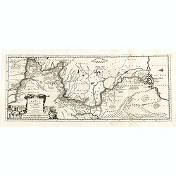
Le Cours de la Riviere de Wolga Anciennement appellee RHA. Selon la Relation d'Olearius.
Map of the Volga River after Olearius' and published by Pieter van der Aa.Olearius's map of the lower Volga is the most important map 17th Century map of the River. Decor...
Date: Leiden, 1729
Selling price: ????
Please login to see price!
Sold in 2016
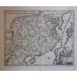
Imperii Sinarum.
Map of China. Along the northern border the Great Wall is visible. Note a large, fancyful lake named Kia Lacus which is the source of five large rivers. The map shows als...
Date: Amsterdam, 1729
Selling price: ????
Please login to see price!
Sold in 2016
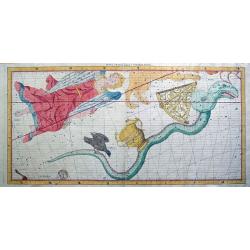
Hydra Crater Corvus Sextans Virgo.
A rare and large celestial chart by John Flamsteed published in his "Atlas Coelestis". Flamsteed worked with Halley who published his work after his death. All...
Date: London, 1729
Selling price: ????
Please login to see price!
Sold in 2014
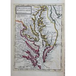
Virginia and Maryland.
Title: 'VIRGINIA AND MARYLAND by H. Moll Geographer' from 'Atlas minor: or a new and curious set of sixty-two maps...' A charming map in Molls unique style.
Date: London, 1729
Selling price: ????
Please login to see price!
Sold in 2015
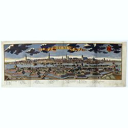
Bremen.
A spectacular panoramic of Bremen, with legends numbered from 1-20 in German. With the title in a banderol.After a design by Friedrich Bernhard Werner (1690-1776) who wa...
Date: Augsburg, 1729
Selling price: ????
Please login to see price!
Sold in 2021
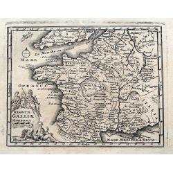
Regnum Galliae Moderna
Charming copper engraved map of France from a rare atlas by Zurner and Weigel. With many place names. Decorated with a title cartouche surrounded by figures.
Date: Nuremberg, 1729
Selling price: ????
Please login to see price!
Sold in 2015
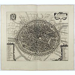
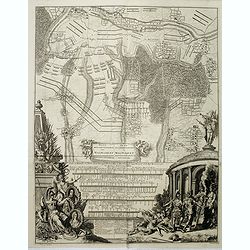
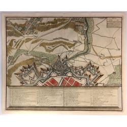
BRUGE een der voornaamste steden van Vlaandren / L'une desPrincipales Villes de Flandre. . .
Detailed plan of Brugge taken from the rare work "Histoire Militaire du Prince Eugene de Savoye, du Prince et Duc de Marlborough, et du Prince de Nassau-Frise" ...
Date: The Hague, Isaac van der Kloot, 1729
Selling price: ????
Please login to see price!
Sold in 2015
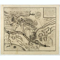
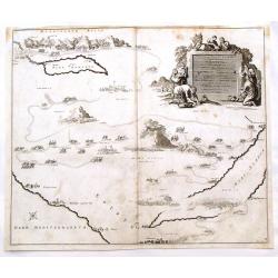
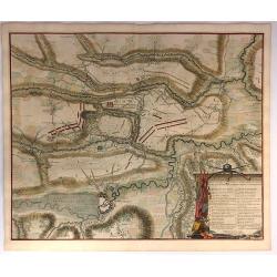
Plan de la Glorieuse Bataille donnee le 16 aout, 1717. Proche de Belgrade...
Title also in Dutch: ""Plan der Roemrugtige Veldslag Voorgevallen den 16 Augustus 1717 Digt by Belgrade ". Oriented to the southeast. Page placement in low...
Date: The Hague, van der Kloot, 1729
Selling price: ????
Please login to see price!
Sold in 2022
Carte la plus-nouvelle & plus-exacte du royaume de Perse avec ses côtes, villes maritimes, tous les pays qui en dependent, & ses lieux circonvoisins. . .
Detailed map of Persia with part of the Arabian Peninsular, Caspian Sea. The river Oxus is shown in present-day Uzbekistan. The region is labeled BUCHARESSEM, with the to...
Date: Leiden, 1729
Selling price: ????
Please login to see price!
Sold in 2025
Plan der Glorieuse Veldislag van Malplaquet
A plan of the Battle of Malplaquet gained by the Allies Sep.11th 1709 , by the Duke of Marlborough. It was the last great battle in the War of the Spanish Succession (170...
Date: Paris, 1729
Selling price: ????
Please login to see price!
Sold in 2020
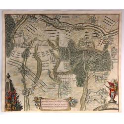
Plan de la Bataille D'Oudenaerde.
A plan of the Battle of Oudenard fought on July 11th 1708. A finely engraved plan with excellent detail of the fortifications of Oudenaerde in Belgium. Full hand coloring...
Date: Paris, 1729
Selling price: ????
Please login to see price!
Sold in 2018
Plan Van de Attaque Van Ryssel & Plan de l'Attaque de Lille
Plans of the attacks on Ryssel/Lille on October 22nd, 1708 by the Duke of Marlborough. It was one of the last great battles in the War of the Spanish Succession (1701–1...
Date: Paris, 1729
Selling price: ????
Please login to see price!
Sold in 2023
Carte du Gouvernement de L'Isle de France...
A fine map of the Isle de France (Paris) region of France by Peter Van Der Aa in Paris. From the book: “La Geographie Moderne, Naturelle, Historique & Politique” ...
Date: Leiden, 1729
Selling price: ????
Please login to see price!
Sold in 2016
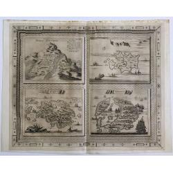
Bergh Cinthus ; Sara ; Eylant Cerigo ; Santorini
A beautiful copper engraving by Van Der Aa of 4 Greek islands, all with a very nicely designed border.
Date: 1729
Selling price: ????
Please login to see price!
Sold in 2016
Orbis terrarum typus de integro in plurimis emendatus auctus et icunculis illustratus.
Outstanding and rare example of a bible world map based on the Visscher bible map from 1657 (Shirley 401/414). This map is larger in size and has an extra engraved frame ...
Date: Minden, 1729
Selling price: ????
Please login to see price!
Sold in 2017
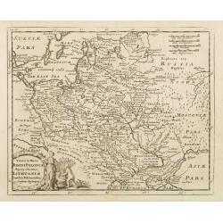
Grande Pologne et Prusse avec les frontières de la Misnie, Lusace, Moravie et Lithuanie
Fine map of Poland. This well executed engraving was published in 1729 and 1727 by Pieter van der AA, in Leiden in "Les Voyages tres-curieux et tres-renommez faits e...
Date: Leiden, 1729
Selling price: ????
Please login to see price!
Sold in 2020
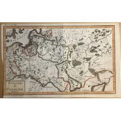
Royaume de Pologne.
Striking map of Poland. It is from “METHODE POUR ETUDIER L’HISTOIRE” by L’Abbe Lenglet du Fresnoy, pulished in Paris in 1729. The map is quite rare and is not now...
Date: Paris, 1729
Selling price: ????
Please login to see price!
Sold in 2019
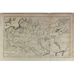
Royaume de Pologne.
Striking map of Poland. It is from “METHODE POUR ETUDIER L’HISTOIRE” by L’Abbe Lenglet du Fresnoy, published in Paris in 1729. The map is quite rare and is not no...
Date: Paris, 1729
Selling price: ????
Please login to see price!
Sold in 2018
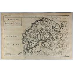
Scandinavie ou Royaume du Nort.
Striking map of Scandinavia. It is from “METHODE POUR ETUDIER L’HISTOIRE” by L’Abbe Lenglet du Fresnoy, published in Paris in 1729. The map is quite rare and is n...
Date: Paris, 1729
Selling price: ????
Please login to see price!
Sold in 2018