Browse Listings
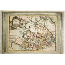
Canada ou Nouvelle France..
Beautifully engraved map of northeastern North American and the Great Lakes region based on Delisle's important map of 1703. The Great Lakes are reasonably well delineate...
Date: Amsterdam, 1730
Selling price: ????
Please login to see price!
Sold in 2012
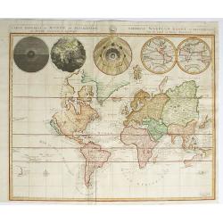
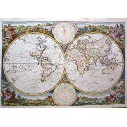
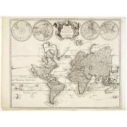
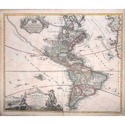
Carte Generale du Monde, ou Description du Monde Terrestre & Aquatique
This is Pierre Mortier's unique world map drawn on Mercator's projection. It depicts California as an island and the Detroit d'Anian connected by dotted lines through the...
Date: Amsterdam, 1730
Selling price: ????
Please login to see price!
Sold in 2012
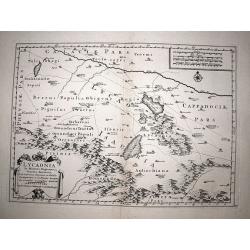
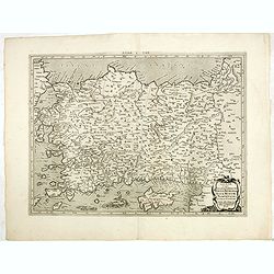
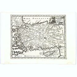
Lycaonia.
Very scarce map of the Lycaonia region of central modern day Turkey, a region rarely mapped in any detail. Published by Covens & Mortier in 1730, a reworked copy of t...
Date: Amsterdam, 1730
Selling price: ????
Please login to see price!
Sold in 2017
![[Engraved horizon ring for a 20cm diameter terrestial globe, together with terrestrial and celestial north and south pole calottes.]](/uploads/cache/32257-250x250.jpg)
[Engraved horizon ring for a 20cm diameter terrestial globe, together with terrestrial and celestial north and south pole calottes.]
Engraved horizon ring for a 20cm diameter terrestrial globe, together with terrestrial and celestial north and south pole calottes, engraved by Johann Georg Puschner.The ...
Date: Nuremberg, 1730
Selling price: ????
Please login to see price!
Sold in 2012
![Portugalliae et Algarbiae. [with large Regnum Brasiliae...inset]](/uploads/cache/32345-250x250.jpg)
Portugalliae et Algarbiae. [with large Regnum Brasiliae...inset]
Decorative map of Portugal, ornated with a large title cartouche, with Neptune, a queen, cherubs, coats of arms and the Portuguese fleet. In lower right inset map of Braz...
Date: Augsburg, 1730
Selling price: ????
Please login to see price!
Sold in 2013
Cataloniae principatus et Ruscionis ae Cerretaniae Comitatuum. . .
Decorative map of Catalonia in southern Spain with a large title cartouche with cherubs and coats of arms.A second state.
Date: Augsburg, 1730
Selling price: ????
Please login to see price!
Sold in 2012
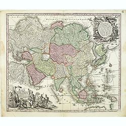
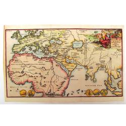
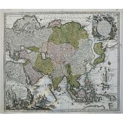
Asia cum omnibus Imperiis, Provinciis, Statibus et ..
A finely engraved and decorative mid-18th century map published in Augsburg, Germany and incorporating two large decorative title cartouches upper right and bottom left. ...
Date: Augsburg, 1730
Selling price: ????
Please login to see price!
Sold in 2012
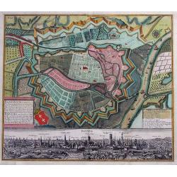
Dantiscum f. Gedanum.../ Dantzig eine berühmte...
SCARCE town-plan of Danzig (Gdansk) in Poland. Superbly engraved and very detailed map of the city and the fortifications. Also showing fields, woods, a few buildings, ou...
Date: Augsburg, 1730
Selling price: ????
Please login to see price!
Sold in 2013
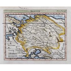
Moscovie.
Attractive small map of parts of Russia. Detailed map, includes Riga, Kiev, Moscow, Astrachan, Kazan, Perm, Smolensk, Crimea, many rivers, etc.
Date: ca. 1730
Selling price: ????
Please login to see price!
Sold in 2012
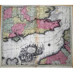
La plus grande partie de la Manche, qui contient les cotes d' Angleterre et celles de France...
Superb map of the English Channel, also showing England including Gloucester, Oxford, London and Colchester, with the Post Roads marked. With French coast including Calai...
Date: Augsburg, 1730
Selling price: ????
Please login to see price!
Sold in 2012
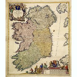
Hiberniae regnum. . .
A detailed and decorative map of Ireland, with an attractive uncolored title cartouche.
Date: Nurnberg 1730
Selling price: ????
Please login to see price!
Sold in 2012
Mappa geographiae naturalis sive Tabella Synoptica.
Exceptional, large, rare decorative cartographical curiosity including most of the names used in cartography, in Latin and German. Left bottom a very decorative cartouche...
Date: Augsburg, 1730
Selling price: ????
Please login to see price!
Sold in 2012
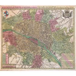
Le Plan de Paris, ses Faubourgs et ses Environs...
A spectacular city plan of Paris illustrating with deepest detail churches, palaces, streets, gardens, etc. The work embellished by a compass rose and the royal coat of a...
Date: Augsburg, 1730
Selling price: ????
Please login to see price!
Sold in 2014
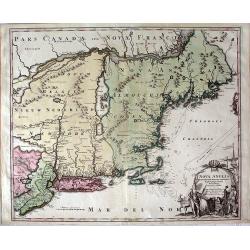
Nova Anglia Septentrionali Americae implantata Anglorumque coloniis florentissima ... Ioh. Baptista Homann Sac. Caes Maj ... Cum Privilegio ... .
This attractive map shows all of "Nova Anglia" (New England), most of "Nieuw Nederland" (present day New York), "Western and Eastern New Jarsey&...
Date: Nurnberg, c.1730
Selling price: ????
Please login to see price!
Sold in 2013
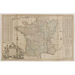
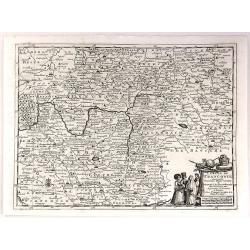
A NEW AND EXACT MAP OF FRANCE...
Decorative two-sheet map of France. Very detailed with towns, rivers, etc. Postal roads are marked with distances between points indicated in leagues. Battle sites in whi...
Date: London, c1730
Selling price: ????
Please login to see price!
Sold in 2014

Nova et accurata cominatus Zelandiae Tabula . . .
Fine and detailed map of the province of Zeeland. Originally issued by Cornelis Allard, now re-published with updated address by the Amsterdam publishers' Covens and Mort...
Date: Amsterdam, 1730
Selling price: ????
Please login to see price!
Sold in 2013

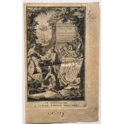
De Kerk en Weereldlyke uyt d\'Aal-Oude.
Title page from "Te Leyden", published by Johannes van Abkoude in 1730. Note the lady in blue holding a globe of the world. Jan Goeree (1670-1730) was a painte...
Date: Amsterdam, 1730
Selling price: ????
Please login to see price!
Sold in 2013
De Tweede Weereld Door Noachs Dry Zonen Bevolkt
This Charming copper plate etched map shows the world as known after the Great Flood. The title cartouche features Noah and his sons. The four coins along the bottom repr...
Date: Amsterdam, 1730
Selling price: ????
Please login to see price!
Sold in 2013
Werelt Caert.
The map is based on Nicolas Visscher's map of 1663, drawn by Daniel Stoopendaal for publication in the Keur Bible. This map depicts the world on a hemisphere projection ...
Date: Dordrecht, (1663) 1730
Selling price: ????
Please login to see price!
Sold in 2013
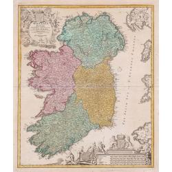
Hiberniae regnum ...
A detailed and decorative map of Ireland, with attractive cartouches.
Date: Nurnberg, 1730
Selling price: ????
Please login to see price!
Sold in 2013
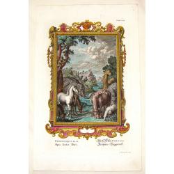
Opus Sextae Diei.
Very fine hand-colored copper engraving featuring the creation of the world - Day 6. (Genisis Chapter I, Verses 24 & 25). It features a group of animals and is framed...
Date: Augsburg, 1730
Selling price: ????
Please login to see price!
Sold in 2013
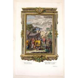
Creation of the Golden Calf.
Very fine hand-colored copper engraving featuring the creation of the golden calf. (Exodus Chapter 32, Verse 4). It features a group men surrounding the new "golden ...
Date: Augsburg, 1730
Selling price: ????
Please login to see price!
Sold in 2016
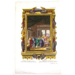
Socrus Petri Sebricitans Sanatur.
Very fine hand-colored copper engraving featuring Jesus healing the centurian's servant. (Matthew Chapter VIII, Verses 14 & 15). It features a group standing over the...
Date: Augsburg, 1730
Selling price: ????
Please login to see price!
Sold in 2016
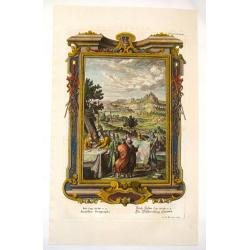
Israelitae Geographi.
Very fine hand-colored copper engraving featuring the Israelites reading maps. It features a group of soldiers and other men studying very large maps and the image is fra...
Date: Augsburg, 1730
Selling price: ????
Please login to see price!
Sold in 2016
Platte Kaart van de geheele Werelt.
This scarce and unusual map of the world is derived from Pierre Mortier's Carte General du Monde of 1700. The map is on Mercator's projection and depicts California as an...
Date: Amsterdam, 1730
Selling price: ????
Please login to see price!
Sold in 2013
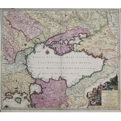
Nova et accurata Tartariae Europae seu minoris et in specie Crimeae delineatio geographica. . .
Map depicting the Black Sea with the peninsula Krim and its bordering countries, showing Asia Minor,Turkey, Bulgaria, Beesarabia, Armenia, Georgia and Ukraine etc.
Date: Augsburg, 1730
Selling price: ????
Please login to see price!
Sold in 2014
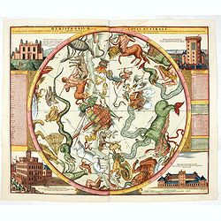
Hemisphaerium Coeli Australe. . .
Magnificent celestial chart drawn by the famous scientist Johann Gabriel Doppelmayr. Large circular charts of the southern hemisphere constellation, with decorative vigne...
Date: Nuremberg, 1730
Selling price: ????
Please login to see price!
Sold in 2020
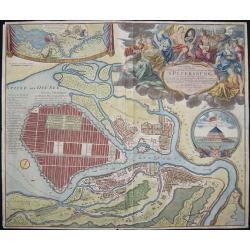
Topographische Vorstellung der Neuen Russischen Haupt-Residenz und See- Stadt St. Petersburg sammt ihrer zu erst aufgerichten Festung
Map shows a city map of St. Petersburg, a beautiful cartouche, a location map of St. Petersburg and Chronschloss. Homann was born in Oberkammlach near Kammlach in the Ele...
Date: Nuremberg, 1730
Selling price: ????
Please login to see price!
Sold in 2015
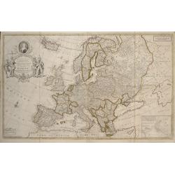
To Her Most Sacred Majesty Carolina Queen of Great Britain, France and Ireland, This Map of Europe According to the Newest and most Exact Observations is most Humbly Dedicated by your Majesty's most Obe
This edition was published by J. Bowles, T. Bowles, P. Overton, J. King, in London c.1730. Two sheets conjoined, total 595 x 975mm. Moll's large format map of Europe, ded...
Date: London, 1730
Selling price: ????
Please login to see price!
Sold in 2017
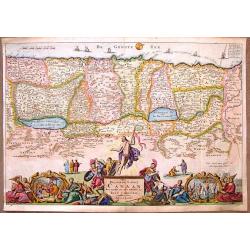
Het Beloofde Landt Canaan Door Wandelt van Onsen Salichmaecker Iesu Christo Neffens Syne Apostelen.
Oriented to the West, this map covers the Holy Land to just beyond the Jordan River. This map was published by the Keur family in the "KEUR BIBLE".Daniel Stoope...
Date: Amsterdam, 1730
Selling price: ????
Please login to see price!
Sold in 2018
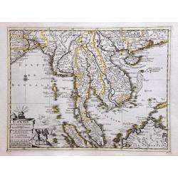
L'Inde de la le Gange, suivant les nouvelles observations.
A decorative map of Malaysia, Thailand, Indo China and the Northern parts of the islands of Sumatra and Borneo. Singapore marked as Sincapour. Pieter van der Aa is highl...
Date: Amsterdam, c. 1730
Selling price: ????
Please login to see price!
Sold in 2014
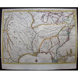
Carte de la Louisiane et du cours du Mississipi.
Shows Indian villages, "nations derangees, nations detruites," the route of de Soto, Moscoso, Cavelier, Tonty and Denis, etc. Relief shown pictorially. Covers a...
Date: Amsterdam, 1730
Selling price: ????
Please login to see price!
Sold in 2014
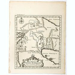
Scheuzcher's Iter ad Ophir.
A striking map of Africa and Arabia featuring Sumatra, The Maldive Islands and the Persian Gulf. The map is from Scheuzcher's "PHYSICA SACRA" from 1730 and was ...
Date: Augsburg, 1730
Selling price: ????
Please login to see price!
Sold in 2017
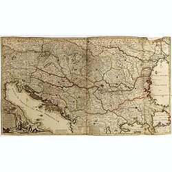
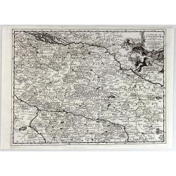
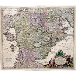
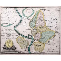
Novissima Tabula Regni Hungariae et Regionum . . . ut Transilvaniae. Valachiae. Moldaviae Serviae. Romaniae. Bulgariae Bessarabiae. Croatiae. Bosniae. Dalmatie. Slavoniae . . .
A large and impressive map of Central Europe including Hungary, the Danube Delta, Transylvania, Walachia, Moldavia, Croatia, Bosnia, Dalmatia, Slavonia, Morlachia and the...
Date: Amsterdam, 1730
Selling price: ????
Please login to see price!
Sold in 2015
Carte des Isles d'Acores.
Uncommon and detailed map of the Azores.
Date: Amsterdam, 1730
Selling price: ????
Please login to see price!
Sold in 2015
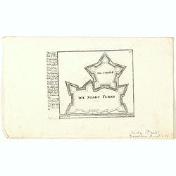
Die Stadt Terky. (Tarki)
Plan of Tarki, with a description and key to the left. Tarki is an urban locality under the administrative jurisdiction of Sovetsky City District of the City of Makhachka...
Date: Augsburg, 1730
Selling price: ????
Please login to see price!
Sold in 2015
Accurata Designatio Celebris Freti prope Andalusiae Castellum Gibraltar...
Very decorative large-scale map of southern Spain. Shows the area from Cadiz and Jerez to Malaga and Motril in great detail. Includes two inset maps of Minorca and Ceuta,...
Date: Augsburg, 1730
Selling price: ????
Please login to see price!
Sold in 2016
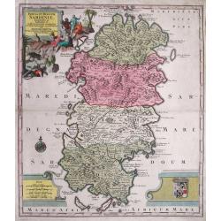
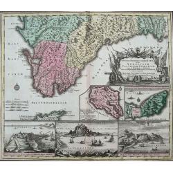
Insula et Regnum Sardiniae,. . .
Fine map of Sardinia, showing the island in great detail. Decorated with a large title cartouche with figures and animals. Further enhanced with a large coat of arms, dis...
Date: Augsburg, 1730
Selling price: ????
Please login to see price!
Sold in 2015
Tab. I. Asiae, in qua Galatia, Cappadocia, Pontus, Bithynia, Asia Minor, Pamphylia, Lycia, ac Cilicia... (With Cyprus)
A fine Ptolemaic map of Turkey and Cyprus showing its ancient political divisions. Two fierce sea monsters fill the Mediterranean Sea. Decorated with a strapwork title ca...
Date: Amsterdam, 1730
Selling price: ????
Please login to see price!
Sold in 2015
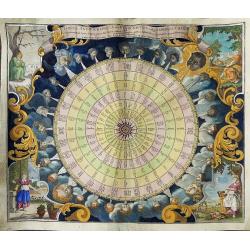
Tabula Anemographica seu Pyxis Nautica, vulgo Compass Charte.
Uncommon wind chart, it shows the compass disc divided in 32 sectors, with text in six languages (German, Dutch, Italian, Latin, French and Spanish).Surrounding the compa...
Date: Augsburg, circa 1730
Selling price: ????
Please login to see price!
Sold in 2016
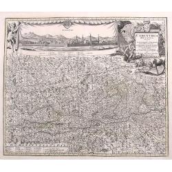
Carinthia Ducatus...
A very decorative and detailed map of Carinthia in Austria. Filled with place names, roads, rivers, lakes, mountains,... A fine large panorama of the city of Klagenfurt i...
Date: Augsburg, ca. 1730
Selling price: ????
Please login to see price!
Sold in 2017
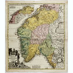
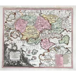
Norvegiae Accurata Tabula in qua Praefecturae quinque Generales. . .
Johann Baptist Homann's well-engraved map has a large decorative cartouche. Detailed map of Norway. The southern part of the country is the focus of the main map, while t...
Date: Nuremberg, ca. 1730
Selling price: ????
Please login to see price!
Sold in 2020
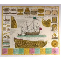
Neue Tafel vor alle Liebhabers und See-fahrende Personen Stellet vor ein Orlog oder Kriegs-Schiff mit seinen volligen Tow & Seilwerck Sampt einen Durchgeschnittnen Schiff...
Interesting engraving of a warship (a three-masted, 96-gun man-o-war) at anchor, illustrating every aspect of its design and construction. Beneath the main illustration i...
Date: Nuremberg, ca 1730
Selling price: ????
Please login to see price!
Sold in 2016
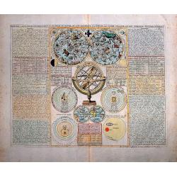
Premiere Carte pour l'Introduction a l'Historie du Monde ou lon Remarque la Sphere le Globe Celeste, et les Differens Sistems du Monde
A nice folio sheet with a central panel containing a twin celestial hemisphere map, armillary sphere, small double hemisphere terrestrial map (THE ISLAND OF CALIFORNIA is...
Date: Paris, ca 1730
Selling price: ????
Please login to see price!
Sold in 2016
Totius Americae Septentrionalis et Meridionalis
A very decorative, richly decorated map of North and South America. The title cartouche on the bottom left is copied from De Fer's map of 1699, while the cartouche contai...
Date: Nuremberg, ca. 1730
Selling price: ????
Please login to see price!
Sold in 2016
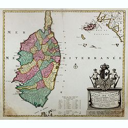
Nieuwe en Nette Afteekening van het Eyland Corsica en het Eyland Elba vertoonende alle desselfs Havenen, Steeden en Rivieren. Nieuwe en Nette Afteekening van het Eyland of Koninkryk Sardinia vertoonende alle desselfs Zee Havenen Anker Plaetsen Rivier ...
An extremely detailed, large sea chart of Corsica, Sardinia and Elba, with many sailing ships, compass roses, decorative cartouches, coat of arms, etc.One of the most dec...
Date: Amsterdam, 1730
Selling price: ????
Please login to see price!
Sold in 2020
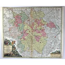
Cercle du Haut Rhin...
A detailed map by Pierre van Der Aa of the German province of Haut Rhin, following the new observations of the “Academie Royale des Sciences”. It has a beautiful cart...
Date: Leiden, 1730
Selling price: ????
Please login to see price!
Sold in 2016
Cercle de la Basse Saxe.
A detailed map by Pierre van Der Aa of the German province of Lower Saxony, following the new observations of the “Academie Royale des Sciences”. It has a beautiful c...
Date: Leiden, 1730
Selling price: ????
Please login to see price!
Sold in 2016
Cercle de Franconie.
A detailed map by Pierre van Der Aa of the German province of Franconie, following the new observations of the “Academie Royale des Sciences”. It has a beautiful cart...
Date: Leiden, 1730
Selling price: ????
Please login to see price!
Sold in 2016
Le Duche de Lunebourg.
A detailed map by Pierre van Der Aa of the German province of Lunebourg following the new observations of the “Academie Royale des Sciences”. It has a beautiful carto...
Date: Leiden, 1730
Selling price: ????
Please login to see price!
Sold in 2016
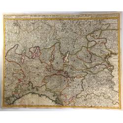
De Stoel des Oorlogs in Italien...
A large and detailed map of Northern Italy by Visscher & Schenk. It was printed on two conjoined sheets of paper. It shows the centre of the war in Italy in the state...
Date: Amsterdam, ca. 1730
Selling price: ????
Please login to see price!
Sold in 2016
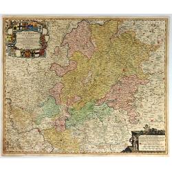
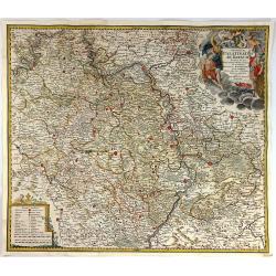
S.R.I. Cirulus Rhenanus Superior.
A beautifully detailed Homann Heirs map of Upper Rhine region. Covers from Coblentz eastward as far as Schweinfurt; northwards as far as Gottingen; and southwards as far ...
Date: Nuremberg, 1730
Selling price: ????
Please login to see price!
Sold in 2016
Exactissima Palatinatis ad Rhenum.
A beautifully detailed Homann Heirs map, covering southern part of the river Rhine. Includes the towns of Frankfurt, Heidelberg, Neustadt, Saarbrücken, Mainz, etc.Enhanc...
Date: Nuremberg, 1730
Selling price: ????
Please login to see price!
Sold in 2016
Representation symbolique et ingenieuse projettee en Siege et en Bombardement, comme il faut empecher prudemment les attaques de L'Amour./ Symbolische Sinnreiche in einer Belagerung u. Bombardirung entworffene Vorstellung wie man den anfallen und versuchu
Copper engraved map with old hand-coloring; overall size 54 x 63 cm; plate size 50 x 58 cm. A unique opportunity to purchase a rare fantasy map by Seutter, depicting a ba...
Date: Augsburg, ca. 1730
Selling price: ????
Please login to see price!
Sold in 2016
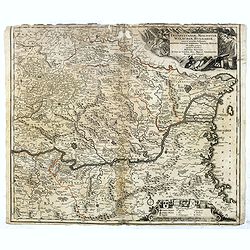
Transylvaniae, Moldaviae, Walachiae, Bulgariae nova et accurata Delineatio, Magnam Partem Hodierni Theatri Bellici ob oculos ponens opera et fumtibus .
Uncommon map showing Southeast Europe with Transylvania, Moldavia, Bulgaria and the Walachei. With the mouth of the river Danube into the Black Sea. In the upper right co...
Date: Nurember, 1730
Selling price: ????
Please login to see price!
Sold in 2016
Accurata Utopiae Tabula das ist der Neu entdeckten Schalck Welt. . .Schlarraffenlandes. . .
Schlarraffenland is the German Fool's Paradise, a land of vice and debauchery, from a satire by Hans Sachs in the 16th century. Also, despite the name of Utopia stated in...
Date: Nuremberg, 1730
Selling price: ????
Please login to see price!
Sold in 2017
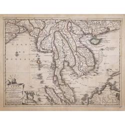
L'Inde de la le Gange, Suivant les Nouvelles Observations.
An attractive detailed map of Malaysia, Thailand, Indo-China, Sumatra, Borneo and Singapore, spelt as "Sincapour" on the map from the Covens and Mortier edition...
Date: Amsterdam, 1730
Selling price: ????
Please login to see price!
Sold in 2017
Mappa Geographica in qua Ducatus Lotharingiae et Barr
A very decorative map of the Lorraine region in France. Detail includes that of the towns, cities, and topography. It has a title cartouche showing people hunting and mak...
Date: Nuremberg, 1730
Selling price: ????
Please login to see price!
Sold in 2016

Bavariae Circulus et Electorat In suas quasque Ditiones tam cum Adiacentibus Quam Insertis Regionibus
This map covers a region including Nuremberg, Passau, and Innsbruck. It is densely packed with information, lakes, rivers, towns, and villages. A large figurative title ...
Date: Nuremberg, 1730
Selling price: ????
Please login to see price!
Sold in 2016
Carte du Paradis Terrestre Suivant le Systeme de Mr. Huet et Execute par P. Starck-man,
Eden, or Paridis Terrestre, along the Gehon River, with Mt. Ararat on top of which rests the Arche de Noé, plus the Tigris and Euphrates Rivers, Babylon, Jerusalem, Syri...
Date: Paris, Emery, Saugrain, Pierre Martin, 1730
Selling price: ????
Please login to see price!
Sold in 2016
Title page of: Hedendaegsche Historie of tegenwoordige staet van alle volkeren. Twede deel.
Title page of Isaac Tirion's work on China, Japan, the Philippines, and the Moluccas. A map of the SE Asia region is on the title page. Shows various native people of the...
Date: Amsterdam, 1730
Selling price: ????
Please login to see price!
Sold in 2016

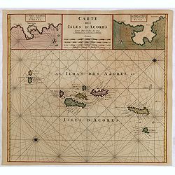
Carte des Isles d'Acores.
Uncommon and detailed map of the Azores. With inset maps of Port de St.Cruz and harbor and town of Angra on the island of Terceira. It was at the time an important port a...
Date: Amsterdam, 1730
Selling price: ????
Please login to see price!
Sold in 2024
Chersonesi quae hodie Natolia Descriptio.
Lovely map of Asia Minor, with some parts of the eastern Greek Archipelago, plus Cyprus and northern Syria. Cherub holding banner title in top right corner.
Date: Amsterdam, ca. 1730
Selling price: ????
Please login to see price!
Sold in 2018
Nouvelle carte de l'Isle de Corse apartenante a la Republique de Genes. . .
Map of Corsica with a splendid baroque cartouche. Carte de la Corse, sur laquelle figure le blason de l’Ile divisé en deux parties égales, la moitié droite est rése...
Date: Amsterdam, 1730
Selling price: ????
Please login to see price!
Sold
Asia Cum Omnibus Imperiis Provinciis Statibus et Insulis Iuxta Observationes Recentissimas et Accuratissimas Correcte et Adornata...
A gorgeous colored example of Seutter's map of Asia, with two spectacular embellishments. It depicts an incomplete northern coastline of Australia, and speculative region...
Date: Augsburg, ca 1730
Selling price: ????
Please login to see price!
Sold in 2017
![Nieuwe wassende grade paskaart, vertoonde t. westerlykste deel der zee kusten van Europa : strekkende van Hitland, of Ysland, tot Vooby t'Naauw van de straat waar in ook vervangen syn, d'Carnarise en Vlaamse Eyan[d] seer dienstif](/uploads/cache/97799-250x250.jpg)
Nieuwe wassende grade paskaart, vertoonde t. westerlykste deel der zee kusten van Europa : strekkende van Hitland, of Ysland, tot Vooby t'Naauw van de straat waar in ook vervangen syn, d'Carnarise en Vlaamse Eyan[d] seer dienstif
An impressive large sea chart of the north Atlantic, extending from Iceland to the Canary islands. It depicts part of North Africa, Spain, Portugal, France, UK, Ireland, ...
Date: Amsterdam, 1730
Selling price: ????
Please login to see price!
Sold in 2016
Roma Victrix
A small map of ancient Rome, showing a few buildings and streets, plus it names several gates (Porta) of the Aurelian Walls!
Date: Nuremberg, ca 1730
Selling price: ????
Please login to see price!
Sold in 2016
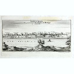
Warschau die gewöhnliche Residenz der Könige in Polen.
Very rare panoramic view of Wachau published by Gabriel Bodenehr, first state without the text on the left.
Date: Augsburg, 1730
Selling price: ????
Please login to see price!
Sold in 2018
![[Antique map of China] Opulentissimum Sinarum Imperium](/uploads/cache/97974-250x250.jpg)
[Antique map of China] Opulentissimum Sinarum Imperium
A highly decorative and strongly engraved map of China that includes the islands of Hainan and Formosa (Taiwan), the Korean peninsula and western Japan.The cartography is...
Date: Augsburg, ca 1730
Selling price: ????
Please login to see price!
Sold in 2017
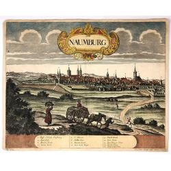
Naumburg.
Attractive colored city view of Naumburg, Germany. I was by Peter Wolff and engraved by Erbert in 1730. There is a lovely baroque title cartouche and a description chart ...
Date: Frankfurt, 1730
Selling price: ????
Please login to see price!
Sold in 2018
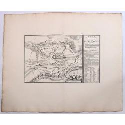
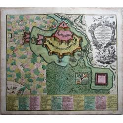
Plan de la Situation du Siege du Quesnoy Investi.
A fine detailed map of the fortifications around the town Quesnoy at the time of the siege in 1712. Le Quesnoy is a commune in the Nord department in northern France.Cove...
Date: Amsterdam, ca. 1730
Selling price: ????
Please login to see price!
Sold in 2019
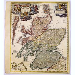
Magnae Britanniae Pars Septentrionalis qua REGNUM SCOTIAE. . .
A large, detailed and decorative map of Scotland with two superb cartouches. They are surrounded by mythical and allegorical figures, five putti, and the Royal & Scot...
Date: Nuremberg, 1730
Selling price: ????
Please login to see price!
Sold in 2017
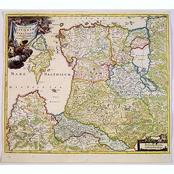
Ducatuum Livoniae et Curlandiae cum vicinis Insulis Nova Exhibitio Geographica. . .
A detailed map of the northern Baltic coast by Homann, pre-dating the privilege given to him. An attractive map covering Estonia and Latvia shows the fortified towns of G...
Date: Nüremberg, 1730
Selling price: ????
Please login to see price!
Sold in 2017
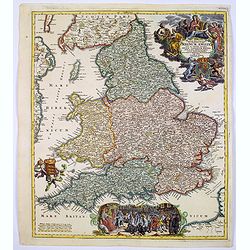
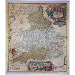
Magnae Britanniae..Regnum Angliae. . .
Johann Baptist Homann's well-engraved map of England and Wales has a large decorative cartouche at top right and a scrolled scene at bottom centre showing the King, (pres...
Date: Nurnberg, 1730
Selling price: ????
Please login to see price!
Sold in 2017
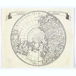
Nuova carta del Polo Artico secondo l'ultime osservazioni ..
From an Italian edition of Solmon's work of this attractive map of a north polar projection.CALIFORNIA IS SHOWN AS AN ISLAND and the Pacific region is completely blank. G...
Date: Rome, 1730
Selling price: ????
Please login to see price!
Sold in 2020
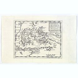
The Island of Celebes, or Macassar with the Islands of Banda, Amboyna. . .
A detailed map of the islands from Eastern Brunei to Timor and part of New Guinea, centered on the Moluccas, including the famous Spice Islands that were once the heart o...
Date: London, ca. 1730
Selling price: ????
Please login to see price!
Sold in 2019
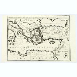
Tabula Peculiaris Regionum, quas Apostoli Perlustrarunt. . .
This map shows the entire eastern Mediterranean, with many ancient places named along the coast lines. This map depicts Paul the Apostle's journey from Jerusalem to Rome,...
Date: Pars, ca. 1730
Selling price: ????
Please login to see price!
Sold in 2020
Magne Britanniae Pars Meridionalis in Qua Regnum Angliae...
A detailed map with a large decorative cartouche at the top right featuring a woman playing the harp, a shield with unicorns and a lion, and two putti. A large scene at t...
Date: Nuremberg, 1730
Selling price: ????
Please login to see price!
Sold in 2017
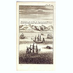
Perspective de la côte de Lucon pres de Manille a 6 lieues de la cote la plus haute montagne etant à l'est.
The print shows most likely Albay Bay on the Southeast Coast of Luzon with mountains risng in the back. Showing Dutch vessels in the foreground, likely those of Olivier v...
Date: Paris / Amsterdam, ca 1730
Selling price: ????
Please login to see price!
Sold in 2017
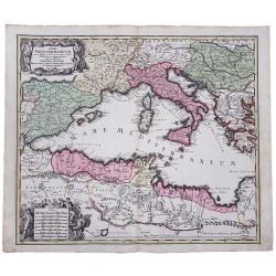
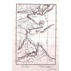
Mare Mediterraneum juxta Regna et Provincias, quas Alluit Distinctum et Cognominatum.
An old colored copperplate map of the middle west Mediterranean Sea. It shows the neighboring countries of Spain, Italy, the Balkans, Greece, as well as the north coast o...
Date: Ausburg, ca. 1730
Selling price: ????
Please login to see price!
Sold in 2019