Browse Listings
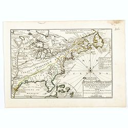
Le Canada, ou Nouvelle France la Florida, la Virginie, Pensilvanie . . .
Fine map is showing the east coast of the United States from the Caribbean up to Newfoundland, with the western border just beyond the Mississippi.The course of the Missi...
Date: Paris, 1705
Selling price: ????
Please login to see price!
Sold in 2020
![L'AMERIQUE, Meridionale et Septenstrionale.[California island]](/uploads/cache/83556-250x250.jpg)
L'AMERIQUE, Meridionale et Septenstrionale.[California island]
A fine map of the Western hemisphere showing California as an island with indented northern coast: Agubela de Cato to north. Includes partial outline of New Zealand. Inte...
Date: Paris, 1705
Selling price: ????
Please login to see price!
Sold in 2020
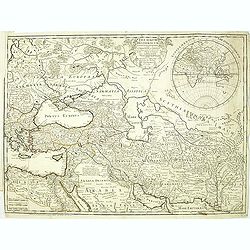
Carte pour servie a l'inteligence de l'histoire de la Cronologie, et de la Geographie des Empires des Assiriens, des Perses, des Egiptiens, et des Chinois.
An interesting sheet with a map of the classical world showing the empires of the Assyrians, Persians, Egyptians and Chinese, with descriptive French text, from Chatelain...
Date: Amsterdam, 1705
Selling price: ????
Please login to see price!
Sold in 2020
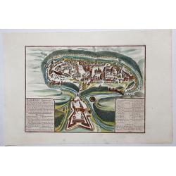
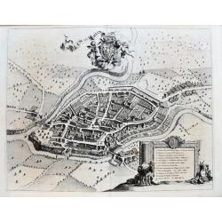
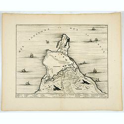
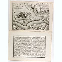
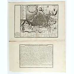
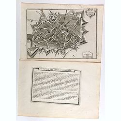
Kamieniec Podolski Ville forte des Estats de pologne et de la Haute Podolie. . .
An uncommon bird's eye view of the city of Kamianets-Podilskyi, located in western Ukraine. The print has in the lower left corner an explanatory panel with numbered (1-1...
Date: Paris, 1705
Selling price: ????
Please login to see price!
Sold in 2020
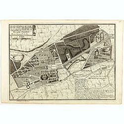
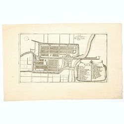
Plan général du Parc du Chau de l'Estang . . .
Plan of the park of l'Estang, from Nicolas de Fer's "L'Atlas curieux ou le Monde réprésente dans des cartes. "The "Atlas Curieux" is a geographic en...
Date: Paris, 1705
Selling price: ????
Please login to see price!
Sold in 2020
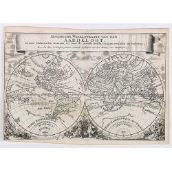
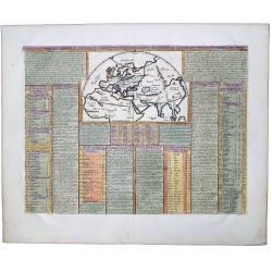
Algemeene Wereldkaart van den Aardkloot. In twee Vlakronden vertoont, en naar de niewste Beschryvingen overzein en verbetert. . .
This delightful double hemisphere map is beautifully decorated with clouds at the top and excellent allegorical representations of the known continents at the bottom. Cal...
Date: Amsterdam/ Utrecht, ca 1705
Selling price: ????
Please login to see price!
Sold in 2020
![[Title page] L'Atlas curieux ou le Monde réprésente dans des cartes. . .](/uploads/cache/45588-250x250.jpg)
[Title page] L'Atlas curieux ou le Monde réprésente dans des cartes. . .
Engraved title page from Nicolas de Fer's "Atlas Curieux". Text heightened with gold and silver, now oxidized. In lower part figures symbolizing mapmaking and a...
Date: Paris, 1705
Selling price: ????
Please login to see price!
Sold in 2021
Le plan de la ville, cité, et université de Paris. Capitale du Royaume de France.
Engraved plan of Paris (22x33cm) with a lettered key to the most important buildings in town, from Nicolas de Fer's "L'Atlas curieux ou le Monde réprésente dans de...
Date: Paris, 1705
Selling price: ????
Please login to see price!
Sold in 2021
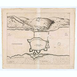
TRAW Ville de la Republique de Venise dans la Dalmatie.
Large view of the port city of Trogir (Trau) in Croatia with the fortress from a half bird's eye view. Joan Blaeu published during his life three town-books of Italy: Cit...
Date: Amsterdam, 1704- 1705
Selling price: ????
Please login to see price!
Sold in 2020
![Atlas. [Complete set of Terrestrial and Celestial Gores]](/uploads/cache/46535-250x250.jpg)
Atlas. [Complete set of Terrestrial and Celestial Gores]
A rare complete set of gores for a pair of 30cm (12-inch) diameter globes, on full uncut sheets with deckle edges. Eimmart is described in Tooley's Dictionary of Mapmaker...
Date: Nuremberg, 1705
Selling price: ????
Please login to see price!
Sold in 2020
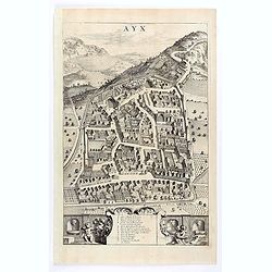
Ayx.
Detailed plan of Aix en Provence, in France. Joan Blaeu published during his life three town-books of Italy: Citta del Vaticano, Rome and Napoli. By the year 1672 a fire ...
Date: Amsterdam, 1704 / 1705
Selling price: ????
Please login to see price!
Sold in 2020
Rumiliacum vulgo Rumilly.
A striking large-scale bird's eye view of Rumilly in the French Alps (Haute-Savoie, Auvergne-Rhône-Alpes). Richly detailed buildings, gardens, bridges, and fields. And w...
Date: Amsterdam, ca 1705
Selling price: ????
Please login to see price!
Sold in 2020
Plan de Batavia.
An excellent example of de Fer's town plan of Batavia (Jakarta) produced early in the 18th century, when the city and region was under the direct control and influence of...
Date: Paris, 1705
Selling price: ????
Please login to see price!
Sold in 2021
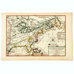
Le Canada, ou Nouvelle France la Florida, la Virginie, Pensilvanie . . .
A fine map is showing the east coast of the United States from the Gulf of Mexico and the Caribbean up to Newfoundland, with the western border just beyond the Mississipp...
Date: Paris, 1705
Selling price: ????
Please login to see price!
Sold in 2021
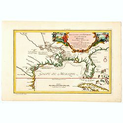
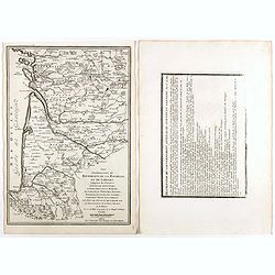
Les Costes aux Environs de la Riviere de Misisipi.
An historically important map of Florida and the Gulf Coast circa 1700 showing especially the estuary of the Mississippi in some detail, more or less correctly located.Th...
Date: Paris, 1705
Selling price: ????
Please login to see price!
Sold in 2021
CORFU Ville de la Republique de VENICE Dans la Dalmatie.
City plan of Corfu, the town and it's fortifications.Joan Blaeu published during his life three town-books of Italy: Citta del Vaticano, Rome and Napoli. By the year 1672...
Date: Amsterdam, 1704/1705
Selling price: ????
Please login to see price!
Sold in 2020
Theatrum Historicum. . . Romani tu Barbarorum. . . Pars Orientalis. . .
Showing the Roman Empire by G. de l'Isle, French cartographer, pupil of Cassini, called Father of Modern Geography. In upper right hand corner eastern hemisphere includin...
Date: Paris, 1705
Selling price: ????
Please login to see price!
Sold in 2012
Theatrum Historicum. . . Romani tu Barbarorum. . . Pars Occidentalis. . .
Showing the Roman Empire by G. de l'Isle, French cartographer, pupil of Cassini, called Father of Modern Geography. In upper left hand corner western hemisphere.Centered ...
Date: Paris, 1705
Selling price: ????
Please login to see price!
Sold in 2012
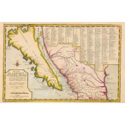
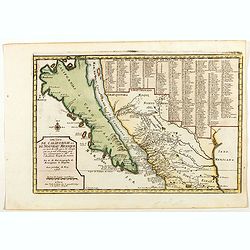
Cette Carte de Californie et du Nouveau Mexique.
A most important map, identifying by numerical code some 314 places in New Mexico, and showing in detail California as an island, although based on Sanson's monumental ma...
Date: Paris, 1705
Selling price: ????
Please login to see price!
Sold
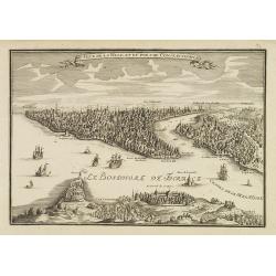
Veue de la ville et du port de Constantinople.
Uncommon bird's-eye view of Istanbul (Constantinople) with Scutari in the foreground, identifying numerous landmarks and a number of ships in the Bosporus.
Date: Paris, 1705
Selling price: ????
Please login to see price!
Sold
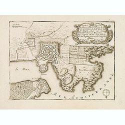
L'Entrée du PORT DE MARSEILLE et le Plan de la Citadelle et du Fort de St. Jean. . .
Early plan of Marseille. From his "Introduction à la fortification".
Date: Paris, 1705
Selling price: ????
Please login to see price!
Sold
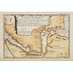
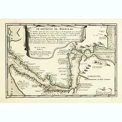
Le Detroit De Magellan Se trouve . . . Il fut decouvert par Ferdinand Magellan. . .
Somewhat uncommon map of the Straits of Magellan, showing soundings, place names and other details in the passage through the Strait. Engraved by the master engraver Inse...
Date: Paris, 1705
Selling price: ????
Please login to see price!
Sold in 2012
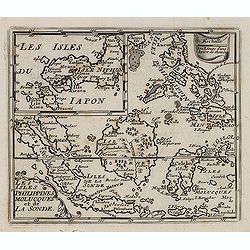
Les isles Philippines, Molucques../Les isles du Iapon.
A map of the Indonesian and Philippines islands with an insert showing the three main Japanese islands, by Nicolas De Fer, Royal French Geographer.
Date: Paris, 1705
Selling price: ????
Please login to see price!
Sold in 2015
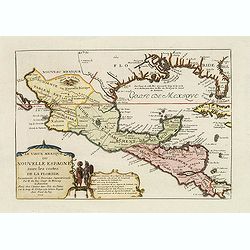
Le vieux Mexique ou nouvelle Espagne. . .
Detailed and important map of Mexico and Central America. The 'Atlas Curieux' was published in parts at first, and then as a complete entity in 1705.
Date: Paris, 1705
Selling price: ????
Please login to see price!
Sold in 2015
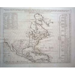
Nouvelle Carte de l\' Amerique Septentrionale dressee sur les plus Nouvelles Observations de Messieurs de l\' Academie des Sciences et des Meilleurs Geographes avec des tables tres instructives et curieuses de la division de tous les Etats.
From: Atlas Historique. A fine folio map with California as an island. All five of the Great Lakes are present; but Lake Erie is unnamed. The Ohio River is shown, but unn...
Date: Amsterdam, 1705
Selling price: ????
Please login to see price!
Sold in 2014

Sr. Francis Drake.
Fine, highly detailed copper engraving of Sir Francis Drake, the famous explorer, Admiral & Circumnavigator. It was engraved by Robert White and comes from the book &...
Date: London, 1705
Selling price: ????
Please login to see price!
Sold in 2018
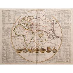
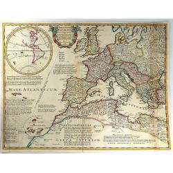
Plan de l\' Histoire Universelle, oulon voit les quatre Monarchies du Monde , et tous les Anciens Etats, aussi bien que ceux qui subsistent aujourdhuy.
Interesting map of the Eastern Hemisphere, with an inset of the Western Hemisphere showing California as and Island. The main map shows the extents of the Roman and Alexa...
Date: Amsterdam, c. 1705
Selling price: ????
Please login to see price!
Sold in 2015
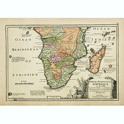
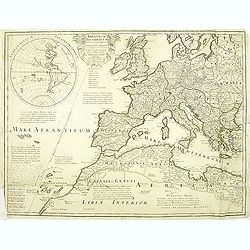
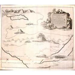
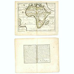
Partie méridionale d'Afrique où se trouvent la Basse Guinée, la Cafrerie, le Monomotapa, le Monoemugi, le Zanguebar et l'isle de Madagascar
The map includes Southern Africa and Madagascar. Engraved by C.Inselin.There is a small legend at the lower border describing the discovery of the Cape by Bartholomew Dia...
Date: Paris, 1705
Selling price: ????
Please login to see price!
Sold in 2018
Le Detroit De Magellan . . . Se trouve . . . Il fut decouvert par Ferdinand . . .
Somewhat uncommon map of the Straits of Magellan, showing soundings, place names and other details in the passage through the Strait. Engraved by the master engraver Inse...
Date: Paris, 1705
Selling price: ????
Please login to see price!
Sold in 2017
Theatrum Historicum .. Romani tu Barbarorum.. Pars Occidentalis..
Engraved map in outline color. Shows forested areas, etc. Relief shown pictorially. Covers Europe and most of North Africa. Includes inset map of the western hemisphere, ...
Date: Paris, 1705
Selling price: ????
Please login to see price!
Sold in 2014
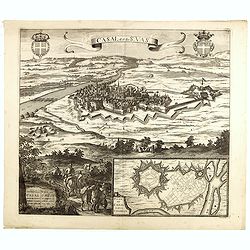
Casal dit de St. Vas. (Casale Monferrato)
A beautifully engraved and richly decorated bird's-eye view of Casale Monferrato in the Piedmont region.Joan Blaeu published during his life three town-books of Italy: Ci...
Date: Amsterdam, 1704/1705
Selling price: ????
Please login to see price!
Sold in 2014
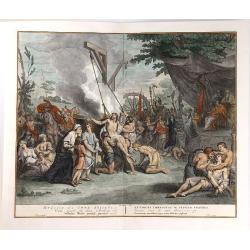
Voyage des Enfans d'Israel dans le Desert Depuis Leux Partie d'Egypte par la Mer Rouge.
This interesting copper engraving map focuses on the Exodus of the children of Israel from Egypt to the Promised Land. Numerous place names and biblical references fill t...
Date: Amsterdam, Covens and Mortier, 1705
Selling price: ????
Please login to see price!
Sold in 2016
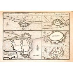
Les Quatre Villes Forestieres, Situees Sur le Rhein, Sent du Cercle de Souabe et a l'Empereur. Par N. de Fer.
Interesting set of four fortified towns on the Rhein River in Swabia, including Constance, Seckingen, Lauffenburg & Waldhust.Copper engraving is by Nicolas de Fer in ...
Date: Paris, 1705
Selling price: ????
Please login to see price!
Sold in 2016

T Ryk van Fez verdeelt in zeven Landschappen
Nicolas Sanson (1600-67), ' father of the French cartography' and founder of the Sanson firm. Atlas ' Cartes générales de toutes les parties du Monde', 1658-70 and a po...
Date: Amsterdam, F. Halma, 1705
Selling price: ????
Please login to see price!
Sold in 2018
Cette Carte de Californie et du Nouveau Mexique.
A most important map, identifying by numerical code some 314 places in New Mexico, and showing in detail California as an island, although based on Sanson's monumental ma...
Date: Paris, 1705
Selling price: ????
Please login to see price!
Sold in 2015
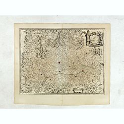
Le Pais Messin ses Dependances et Terre Adiacentes.
Fine hand-colored map centered on Metz in Germany. It was engraved by Nicholas De Fer in Paris in 1705. The Mozelle River flows down the center of the map.
Date: Paris, 1705
Selling price: ????
Please login to see price!
Sold in 2017
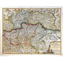
Austriae Archiducatus Pars Inferior
A finely engraved map of Lower Austria, along the Danube River, featuring numerous place names, cities, towns, villages, churches and topography.Vienna, Baden and many ot...
Date: Amsterdam, 1705
Selling price: ????
Please login to see price!
Sold in 2017
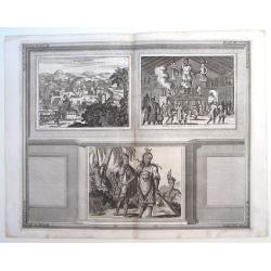
Sasquesahanok, Village palissade en Virginie, partie de l'Amerique/ Temple ou est l'Idole de Vens, adoree en Virginie/ Habillemens des Hommes et Femmes de Virginie
Copper engraving of Native Americans of Virginia by John Harris, from the: 'Navigantium atque Itinerantium Bibliotheca'; or, 'A Compleat Collection of Voyages and Travels...
Date: London, 1705
Selling price: ????
Please login to see price!
Sold in 2015
Cruelty Towards the Seven Brethren.
An interesting copper engraving by Bernard Picart. It features different forms of torture including boiling and tooth extraction. It was engraved by Pool.Bernard Picart (...
Date: Amsterdam, ca. 1705
Selling price: ????
Please login to see price!
Sold in 2019
Theatrum Historicum ad annum Christi quadringentesimu in quo tu Imperii Romani tu Barbarorum...
A splendid map of the Roman Empire, showing its extent in 400 AD, covering most of North Africa, Southern Europe, and Britain as far as the Antonine Wall in Scotland. Ins...
Date: Paris, 1705
Selling price: ????
Please login to see price!
Sold in 2016
L'Afrique dressée sur les dernieres Relations . . .
An interesting small map of Africa by Nicolas de Fer. From his rare "Petit et Nouveau Atlas". The first edition was published in 1697 and was republished in 170...
Date: Paris, 1705
Selling price: ????
Please login to see price!
Sold in 2016
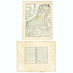
Les XVII Provinces Païs Bas Divisées.
An interesting small map of the Netherlands by Nicolas de Fer. From his rare "Petit et Nouveau Atlas". The first edition was published in 1697 and was republish...
Date: Paris, 1705
Selling price: ????
Please login to see price!
Sold in 2020
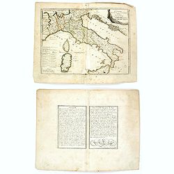
L'Italie divisée en ses principaux estats.
An interesting small map of Italy by Nicolas de Fer. From his rare "Petit et Nouveau Atlas". The first edition was published in 1697 and was republished in 1705...
Date: Paris, 1705
Selling price: ????
Please login to see price!
Sold in 2018
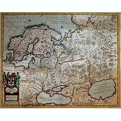
Novissima Russiae Tabula.
A fine and attractive map of Russia.Published by the Allard family in Amsterdam.
Date: Amsterdam, 1705
Selling price: ????
Please login to see price!
Sold in 2017
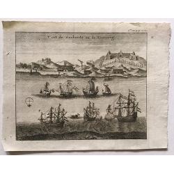
Fort de Zeelande ou de Taiovang.
A rare view of Fort Zeelandia, which was a fortress built over ten years from 1624–1634 by the Dutch East India Company, in the town of Anping (Tainan) on the island of...
Date: ca, 1705
Selling price: ????
Please login to see price!
Sold in 2016

'T Stadhuys van Amsterdam.
Fine view of the City Hall in Amsterdam. A very busy scene with numerous people, horses, dogs, etc. Published in 'Algemene Wereldtbeschrijving', by Francois Halma, printe...
Date: Leeuwarden, 1705
Selling price: ????
Please login to see price!
Sold in 2016
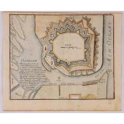
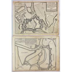
Ostende Ville forte et port de Mer du Comte de Flandre.
A fine view of the fort of Ostende in Belgium. It was published in Paris in 1695.It was engraved by Harmanus van Loon and is from “Atlas Les Forces de le Europe”.Nich...
Date: Paris, 1705
Selling price: ????
Please login to see price!
Sold in 2018
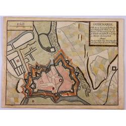
Oudenarde Ville Forte du Comte de Flandre.
A fine plan illustrating the important fortification of Oudenard in Belgium.Nicolas de Fer held the title of Geographer at Louis XIV's court. He was one of the most proli...
Date: Paris, 1705
Selling price: ????
Please login to see price!
Sold in 2019
Carte Nouvelle du Bergamasco Faisant Partie des Etats de la Venise.
This fine map is centered on Bergamo in the Lombardy region of northern Italy. Excellent detail of towns, roads, forts, and more. The map was created to depict the encamp...
Date: Amsterdam, 1705
Selling price: ????
Please login to see price!
Sold in 2017
Description de l'île Formosa en Asie, du gouvernement, des loix, des mœurs & de la religion des habitans. . .
First French edition of one of the most famous fictitious travel books ever published. It offered a complete and detailed description of the island Formosa and the life a...
Date: Amsterdam, d'Estienne Roger, 1705
Selling price: ????
Please login to see price!
Sold
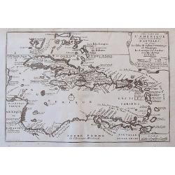
Les Isles De L'Amerique Connues Sous le Nom D'Antilles, ou Sont les Isles de Cuba, St. Domingue et Jamaique, les Lucayes, les Caribes, et celles du Vent.
A detailed copper engraved map of the West Indies, from Florida and the Bahamas until Venezuela and Trinidad. With many place names, islands, bays, and several notes on t...
Date: Paris, 1705
Selling price: ????
Please login to see price!
Sold in 2017
Dendermonde Ville Forte des Pas Bas, du Comte de Flandres & Oudenarde Ville Forte du Comte de Flandre. . .
Dendermonde and Oudenarde, Two (2) Low Country copperplate engravings of fortification cities from Flanders in Belgium, by De Fer in Paris in 1705. From "Les Forces ...
Date: Paris, 1705
Selling price: ????
Please login to see price!
Sold in 2019
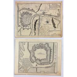
Ostende Ville Forte & Nieuport Port de Mer.
Ostende and Nieuport, Two (2) Low Country copperplate engravings of fortification cities from Flanders in Belgium. By De Fer in Paris in 1705. From "Les Forces de L'...
Date: Paris, 1705
Selling price: ????
Please login to see price!
Sold in 2019
![[Title page] L'Atlas curieux ou le Monde réprésente dans des cartes. . .](/uploads/cache/40738-250x250.jpg)
[Title page] L'Atlas curieux ou le Monde réprésente dans des cartes. . .
Engraved title page from Nicolas de Fer's "L'Atlas curieux ou le Monde réprésente dans des cartes. ". In lower part figures symbolizing mapmaking and architec...
Date: Paris, 1705
Selling price: ????
Please login to see price!
Sold in 2022
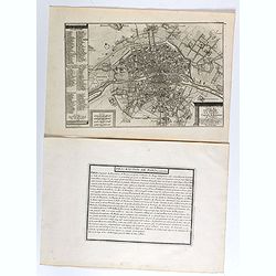
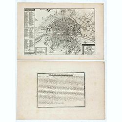
Le plan de la ville, cité, et université de Paris. Capitale du Royaume de France.
Engraved plan of Paris with a lettered key to the most important buildings in town, from Nicolas de Fer's "L'Atlas curieux ou le Monde réprésente dans des cartes. ...
Date: Paris, 1705
Selling price: ????
Please login to see price!
Sold
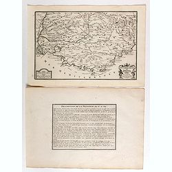
Gouvernement de Provence, generalité d'Aix.
Map of the Provence region, from Nicolas de Fer's "L'Atlas curieux ou le Monde réprésente dans des cartes. "The "Atlas Curieux" is a geographic ency...
Date: Paris, 1705
Selling price: ????
Please login to see price!
Sold
Isle, Rocher, Ville, château et Abbaye du Mont St Michel situé aux confins de Normandie et de Bretagne.
Engraved view of the Mont St Michel, with a numbered key (1-7) from Nicolas de Fer's "L'Atlas curieux ou le Monde réprésente dans des cartes. "The "Atlas...
Date: Paris, 1705
Selling price: ????
Please login to see price!
Sold
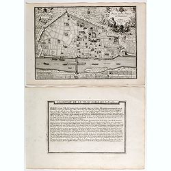
Plan de ville d'Orléans.
Engraved plan of the city of Orléans, from Nicolas de Fer's "L'Atlas curieux ou le Monde réprésente dans des cartes. "The "Atlas Curieux" is a geog...
Date: Paris, 1705
Selling price: ????
Please login to see price!
Sold
Lion.
Engraved plan of the city of Lyon, from Nicolas de Fer's "L'Atlas curieux ou le Monde réprésenté dans des cartes. "The "Atlas Curieux" is a geograp...
Date: Paris, 1705
Selling price: ????
Please login to see price!
Sold
Marseille, ville considerable de Provence fameux port sur la mer de Mérditerranée.
Engraved plan of the city of Marseille, with a numbered key (1-31), from Nicolas de Fer's "L'Atlas curieux ou le Monde réprésente dans des cartes. "The "...
Date: Paris, 1705
Selling price: ????
Please login to see price!
Sold
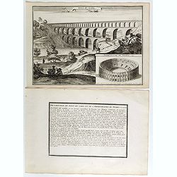
Pont du Gard / Amphiteatre de Nismes.
Engraved view of the Pont du Gard is near Nîmes, with a view of Nîmes famous amphitheater, from Nicolas de Fer's "L'Atlas curieux ou le Monde réprésente dans des...
Date: Paris, 1705
Selling price: ????
Please login to see price!
Sold
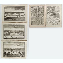
Le Château de Versailles et ses deux aisles, Veües du côté des jardins / Ecuries du Roy a Versailles, veües du côté Louvre / Le Palais de Clagny, près Versailles, Veüe du côté de Paris / La Menagrie de Versailles / Plan du Palais de Trianon / . . .
Six engraved views of different monuments and gardens of Versailles, from Nicolas de Fer's "L'Atlas curieux ou le Monde réprésente dans des cartes. ". The &qu...
Date: Paris, 1705
Selling price: ????
Please login to see price!
Sold in 2017
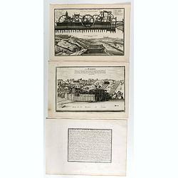
Coupe de la Machine de Marly / Veüe general de la Machine de Marly. (2 plates with text sheet)
Two engraved views of the Machine de Marly, also known as the Marly Machine, from Nicolas de Fer's "L'Atlas curieux ou le Monde réprésente dans des cartes. "....
Date: Paris, 1705
Selling price: ????
Please login to see price!
Sold in 2018
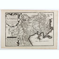
Les environs de Marseille et de son territoire . . .
Map centered on Marseille with nice detail of it surroundings, from Nicolas de Fer's "L'Atlas curieux ou le Monde réprésente dans des cartes. "The "Atlas...
Date: Paris, 1705
Selling price: ????
Please login to see price!
Sold
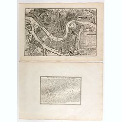
Plan de l'ancienne et nouvelle ville de Dijon.
Engraved plan of the town of Dijon, from Nicolas de Fer's "L'Atlas curieux ou le Monde réprésente dans des cartes. "The "Atlas Curieux" is a geograp...
Date: Paris, 1705
Selling price: ????
Please login to see price!
Sold
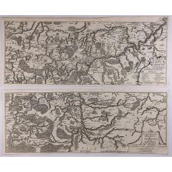
Les Environs de Namur, de Huy et de Charle-Roy and Les Environs de Dinant, de Philippeville et de Charlemont (2 Maps).
Two matching maps of southern Belgium by N. de Fer in 1705. Each features a decorative title cartouche. They centre on the Namur and Dinant regions of Belgium.Nicolas de ...
Date: Paris , 1705
Selling price: ????
Please login to see price!
Sold in 2018
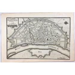
Cologne, Ville Considerable Situee.
A striking 1705 de Fer map of the walled city of Cologne, Germany. Oriented with north to the right, this map identifies the location of the city on the banks of the Rhin...
Date: Paris, 1705
Selling price: ????
Please login to see price!
Sold in 2020
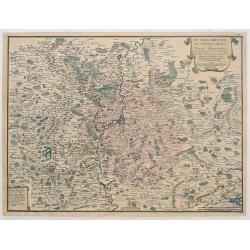
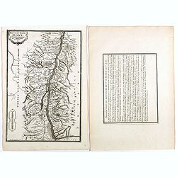
Les Duchez, de Lorraine, et de Bar . . .
Map of the Lorraine region, from Nicolas de Fer's "L'Atlas curieux ou le Monde réprésente dans des cartes. "The "Atlas Curieux" is a geographic ency...
Date: Paris, 1705
Selling price: ????
Please login to see price!
Sold in 2020
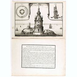
Tour de Cordouan.
View of Cordouan tower, which is nowadays a lighthouse, near the mouth of the Gironde estuary, from Nicolas de Fer's "L'Atlas curieux ou le Monde réprésente dans d...
Date: Paris, 1705
Selling price: ????
Please login to see price!
Sold in 2018
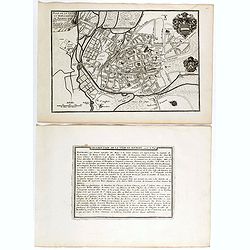
Plan de ville et des Fauxbourgs de Bourges . . .
Plan of Bourges town and its outskirts, from Nicolas de Fer's "L'Atlas curieux ou le Monde réprésente dans des cartes. "The "Atlas Curieux" is a geo...
Date: Paris, 1705
Selling price: ????
Please login to see price!
Sold
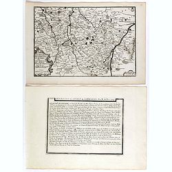
Les generalitez de Bordeaux, de La Rochelle, et de Limoges . . .
Map of the Gascony region, including Bordeaux, La Rochelle and Limoges, with several provinces such as Saintonge, Limousine ..., from Nicolas de Fer's "L'Atlas curie...
Date: Paris, 1705
Selling price: ????
Please login to see price!
Sold in 2021
Les deux Bourgognes Duché et Comté . . .
Map of the Bourgogne region, from Nicolas de Fer's "L'Atlas curieux ou le Monde réprésente dans des cartes. "The "Atlas Curieux" is a geographic enc...
Date: Paris, 1705
Selling price: ????
Please login to see price!
Sold in 2019
Haute et Basse Alsace, suntgout, Brisgou, et Ortenou.
Map of the Alsace region, from Nicolas de Fer's "L'Atlas curieux ou le Monde réprésente dans des cartes. "The "Atlas Curieux" is a geographic encycl...
Date: Paris, 1705
Selling price: ????
Please login to see price!
Sold in 2022
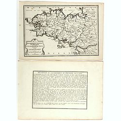
Gouvernement general de Bretagne ou se trouve la Generalité de Nantes.
Map of Bretagne, from Nicolas de Fer's "L'Atlas curieux ou le Monde réprésente dans des cartes. "The "Atlas Curieux" is a geographic encyclopedia of...
Date: Paris, 1705
Selling price: ????
Please login to see price!
Sold in 2020
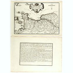
Gouvernement general de Normandie . . .
Map of Normandy region, from Nicolas de Fer's "L'Atlas curieux ou le Monde réprésente dans des cartes. "The "Atlas Curieux" is a geographic encyclop...
Date: Paris, 1705
Selling price: ????
Please login to see price!
Sold in 2018
Environs de Paris.
Map centered on Paris, with its surroundings, from Nicolas de Fer's "L'Atlas curieux ou le Monde réprésente dans des cartes. "The "Atlas Curieux" is...
Date: Paris, 1705
Selling price: ????
Please login to see price!
Sold in 2020
Cette Carte de Californie et du Nouveau Mexique.
A most important map, identifying by numerical code some 314 places in New Mexico, and showing in detail California as an island, although based on Sanson's monumental ma...
Date: Paris, 1705
Selling price: ????
Please login to see price!
Sold in 2019
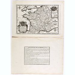
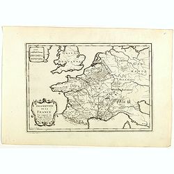
La France ses conquêtes, ses acquisitions et ses bornes . . .
General map of France, from Nicolas de Fer's "L'Atlas curieux ou le Monde réprésente dans des cartes. "The "Atlas Curieux" is a geographic encyclope...
Date: Paris, 1705
Selling price: ????
Please login to see price!
Sold in 2020
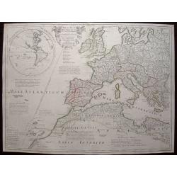
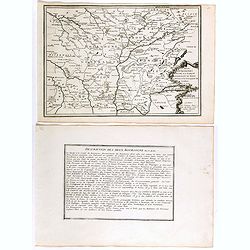
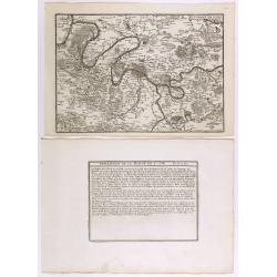
Description de la France par rapport au regne de Clovis et de ses enfants.
Map of France and part of Europe, with great Britain, from Nicolas de Fer's "L'Atlas curieux ou le Monde réprésente dans des cartes. "The "Atlas Curieux&...
Date: Paris, 1705
Selling price: ????
Please login to see price!
Sold in 2022
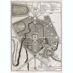
Plan general de Marly.
Plan of the city of Marly, from Nicolas de Fer's "L'Atlas curieux ou le Monde réprésente dans des cartes. "The "Atlas Curieux" is a geographic encyc...
Date: Paris, 1705
Selling price: ????
Please login to see price!
Sold