Browse Listings
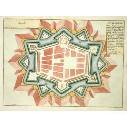
Phalsbourg.
Nice fortification plan of Phalsbourg.
Date: Paris 1705
Selling price: ????
Please login to see price!
Sold
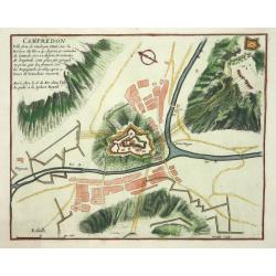
Campredon.
Nice fortification plan of Campredon In the south of France, near the Tarn river.
Date: Paris 1705
Selling price: ????
Please login to see price!
Sold
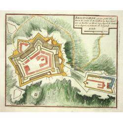
Belle-Garde.
Nice fortification plan of Belle-Garde in the department of Aude.
Date: Paris 1705
Selling price: ????
Please login to see price!
Sold
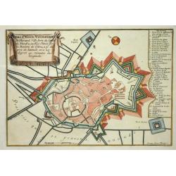
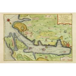
Winoxbergen.
Nice city plan of Winoxbergen in Flanders with the fortification walls.
Date: Paris 1705
Selling price: ????
Please login to see price!
Sold
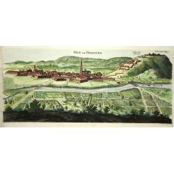
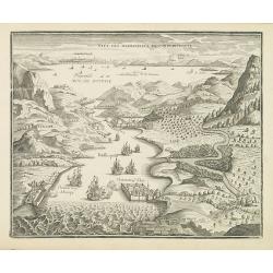
Veue de Fribourg.
Panoramic view of the fortified village of Freiburg in present-day Baden-Württemberg with the Dreisam in the foreground and the forts on the hills protecting the city.
Date: Paris 1705
Selling price: ????
Please login to see price!
Sold
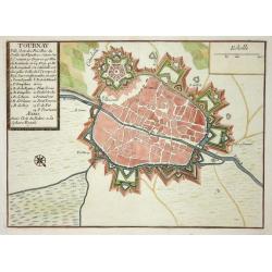
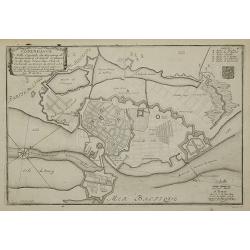
Tournay.
Nice city plan of Tournay in Flanders with the fortification walls and the citadel.
Date: Paris 1705
Selling price: ????
Please login to see price!
Sold
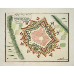
Philippe-ville.
Nice city plan of Philippe-Ville with the fortification walls.
Date: Paris 1705
Selling price: ????
Please login to see price!
Sold
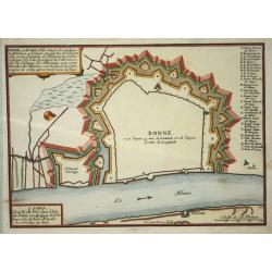
Bonn.
Nice map with Bonn at the Rhine-river.
Date: Paris 1705
Selling price: ????
Please login to see price!
Sold
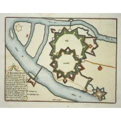
Manheim.
Nice map with Manheim at the Rhine-river.
Date: Paris 1705
Selling price: ????
Please login to see price!
Sold
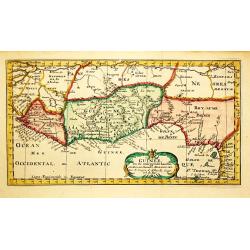
Guinee.
Nicolas Sanson (1600-67), ' father of the French cartography' and founder of the Sanson firm. Atlas ' Cartes générales de toutes les parties du Monde', 1658-70 and a po...
Date: Amsterdam, F.Halma, 1705
Selling price: ????
Please login to see price!
Sold
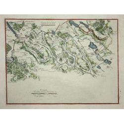
(3 maps) Carte particuliere du Nouveau Canal. Versailles.
This map in three sheets illustrates the canal that would divert water from the Eure River at Pontgouin to Versailles. This massive project was designed by the great mili...
Date: Paris, 1705
Selling price: ????
Please login to see price!
Sold
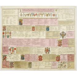
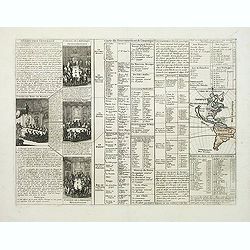
Tabula Historica et Geographica ad breve compendium..
An attractive instructional plate showing the coats-of-arms of various European countries, each with extensive key.
Date: Amsterdam, 1705
Selling price: ????
Please login to see price!
Sold
Le port et la ville de Mahon, le Bourg et le Fort St. Philippe..
Map encompassing the area between Mahon fort St. Philippe in Minorca. Wind rose in the upper left corner.Port Mahon is one of the world's finest natural harbors. During t...
Date: Paris, 1705
Selling price: ????
Please login to see price!
Sold in 2008
L'Afrique Dressée sur les Relat. Et Suivant les Nouvelles decouvertes . . .
Map of Africa. Decorative dedication panel and title cartouche. From his "Atlas Curieux", published 1700-1705, in the rare early edition dated 1700.
Date: Paris, 1700-1705
Selling price: ????
Please login to see price!
Sold in 2011
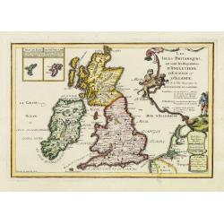
Les isles Britanique, ou sont les Royaumes d'Angleterre, d'Ecosse et d'Irlande. . .
The map includes British Isles, with insets of Ferro and Shetland Islands. Engraved by Vincent de Ginville. From his "Atlas Curieux", published 1700-1705, in th...
Date: Paris, 1705
Selling price: ????
Please login to see price!
Sold in 2011
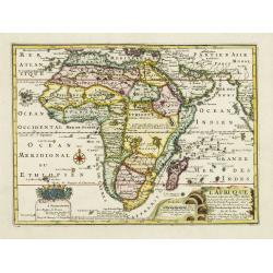
Partie méridionale d'Afrique où se trouvent la Basse Guinée, la Cafrerie, le Monomotapa, le Monoemugi, le Zanguebar et l'isle de Madagascar
The map includes Southern Africa and Madagascar. Engraved by C.Inselin.There is a small legend at the lower border describing the discovery of the Cape by Bartholomew Dia...
Date: Paris, 1705
Selling price: ????
Please login to see price!
Sold in 2011
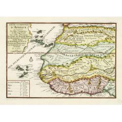
Partie occidentale d'Afrique ou se trouve les Isles Canaries. . .
The map includes Western Africa and the Canary Islands and Cape Verde. Engraved by C.Inselin. From his "Atlas Curieux", published 1700-1705.
Date: Paris, 1705
Selling price: ????
Please login to see price!
Sold in 2011
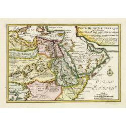
Partie Orientale d'Afrique ou se trouvent l'Egipte, La Nubie. . . L.Arabie . . . Et la Mer Rouge.
The map includes Northern Africa and the Arabian peninsular. Engraved by C.Inselin. Dated in the lower right corner. From his "Atlas Curieux", published 1700-17...
Date: Paris, 1705
Selling price: ????
Please login to see price!
Sold in 2011
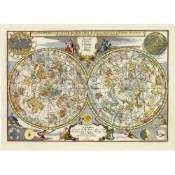
Planispheres Celeste . Par Mr. De la Hire..
Decorative double hemisphere celestial chart, centered on the north and south poles. The constellation figures are derived from the prototypes in Bayer's Uranometria and ...
Date: Paris, 1705
Selling price: ????
Please login to see price!
Sold in 2011
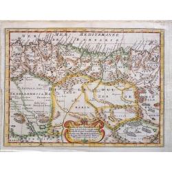
Gedeelte van Barbaryen, waar in legt 't Rijk van Algiers verdeelt in zyne Lanschappen.
Northern part of Algeria. Published by Frans Halma
Date: Utrecht, F. Halma,1705
Selling price: ????
Please login to see price!
Sold in 2013
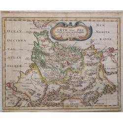
T Ryk van Fez verdeelt in zeven Landschappen, getrokken uit Sanutus enz.
Map of Fez in Morocco. Published by Frans Halma
Date: Utrecht, F. Halma,1705
Selling price: ????
Please login to see price!
Sold in 2013
Copenhague ...
Charming bird's-eye plan of the fortification of the city of Copenhagen.Nicolas de Fer held the title of Geographer at Louis XIV's court. He was one of the most prolific ...
Date: Paris, 1705
Selling price: ????
Please login to see price!
Sold in 2011
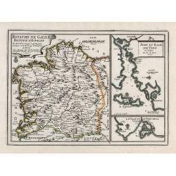
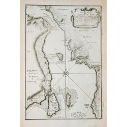
Royaume de Galice province d''Espagne. / Port et rade de Vigo.
Copper engraving by G. Inselin for Nicolas De Fer (1646-1720). Map is dated 1705. Three maps on one sheet. The left map reaches as far south as Caminha on the Miño river...
Date: Paris, 1705
Selling price: ????
Please login to see price!
Sold in 2008
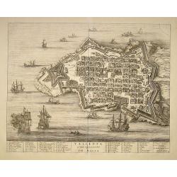
Valleta ou Valet Ville Forte de l''Isle De Malta
Map of the harbor and city of Valletta was originally published Joan Blaeu in the atlas "Theatrum Admiradorum...". Below the map an index referrers to 57 featur...
Date: Amsterdam, 1705
Selling price: ????
Please login to see price!
Sold in 2008
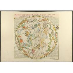
Planisphere Celeste Meridionale (and) Planisphere Celeste Septentrional
Two separate charts of southern and northern Hemisphere according to Philippe de la Hire (1640-1714). Hemisphere with surround of text and engraved dedication to Jean Pau...
Date: Paris, 1705
Selling price: ????
Please login to see price!
Sold in 2008
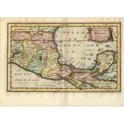
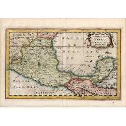
'T Gebiedt van Mexico
A crisply engraved small map focusing on the region of central and southern Mexico down to the Yucatan Peninsula, and the island of Cozumel. Florida is named in the place...
Date: Paris, 1705
Selling price: ????
Please login to see price!
Sold in 2008
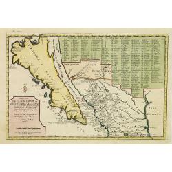
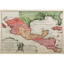
Cette Carte de Californie et du Nouveau Mexique. . .
A most important map, identifying by numerical code some 314 places in New MexicoIt shows in detail California as an island, although based on Sanson's monumental map of ...
Date: Paris, 1705
Selling price: ????
Please login to see price!
Sold in 2008
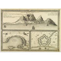
Cap de Bonne Esperance par N.de Fer.
In the upper part a view of the Table Mountain, in lower part Table Bay and the Dutch Castle at Cape of Good Hope.
Date: Paris, 1705
Selling price: ????
Please login to see price!
Sold in 2008
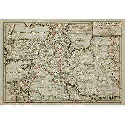
La Perse La Georgie, et la Turquie d'Asie ...
Uncommon map of Turkey, Persia, Palestine and the northern tip of Arabia.
Date: Paris, 1705
Selling price: ????
Please login to see price!
Sold in 2011
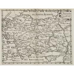
Anatolien. (with Cyprus)
A Dutch edition of Sanson Jr.'s map of Turkey. In the lower right corner is an oversized Cyprus. Engraved by Anthony d'Winter.
Date: Amsterdam, 1705
Selling price: ????
Please login to see price!
Sold in 2022
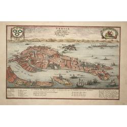
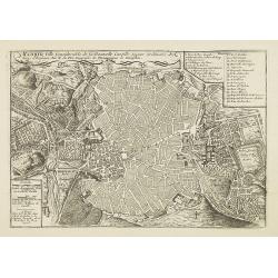
Venise
Attractive bird's-eye plan of Venice clearly depicting the city's landmarks and extending to the outlying islands including Murano. The surrounding lagoon is filled with ...
Date: Paris, 1705
Selling price: ????
Please login to see price!
Sold in 2008
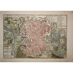
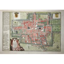
Madrid
A city plan of Madrid with the surroundings. The map has a lot of details, like fields, trees, main buildings and defence walls.
Date: Paris, 1705
Selling price: ????
Please login to see price!
Sold in 2009
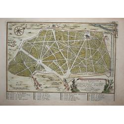
Le bois de Boulogne (Paris)
A print of Le bois de boulogne in Paris, detailed with paths walls trees and buildings and a compass rose.
Date: Paris, 1705
Selling price: ????
Please login to see price!
Sold in 2009
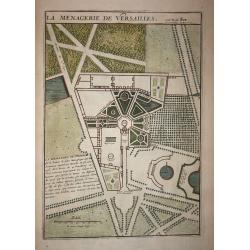
Le Menagerie de Versailles.
A print of a part of the garden of Versaille in Paris, detailed with paths, walls and trees.
Date: Paris, 1705
Selling price: ????
Please login to see price!
Sold in 2008
'T Gebiedt van Mexico
A crisply engraved small map focusing on the region of central and southern Mexico down to the Yucatan Peninsula, and the island of Cozumel. Florida is named in the place...
Date: Paris, 1705
Selling price: ????
Please login to see price!
Sold in 2009
La Haie
Decorative plan of the Dutch city The Hague.
Date: Paris, 1705
Selling price: ????
Please login to see price!
Sold in 2009
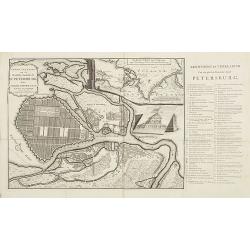
Grond - Tekening van de Russische Hoofdstadt St. Petersburg door Czaer Pieter de Eerste in 't jaer 1703 aengelegt.
Uncommon city plan of Saint Petersburg with keys to the right chart A-E, 1- 66. In upper right an inset map of the river Neva. Text is in Dutch.
Date: Utrecht, 1705
Selling price: ????
Please login to see price!
Sold in 2009
Madrid, Ville Considerable de la Nouvelle Castille, Sejour ordinaire des Roys d'Espagne. Par N. de Fer Geographe de Monseigneur le Dauphin.
Map of the city of Madrid, with a key: 1-26 in upper right corner. The city plan shows the geometric plant of the city, emphasizing the enclosure of old Villa and the Gre...
Date: Paris, 1705
Selling price: ????
Please login to see price!
Sold in 2009
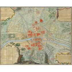
Quatrième plan de la ville de Paris son accroissement et l'etat ou elle êtoit sous le regne de Philipp Auguste...
Very interesting historic plan of Paris. Showing the buildings, city walls, fields and streets. Decorated with three cartouches and a compass rose. An extensive key indi...
Date: Paris, 1705
Selling price: ????
Please login to see price!
Sold in 2009
Le vieux Mexique ou Nouvelle Espagne ? Floride.
Detailed and important map of Mexico and Central America. The 'Atlas Curieux' was published in parts at first, and then as a complete entity in 1705.
Date: Paris, 1705
Selling price: ????
Please login to see price!
Sold in 2009
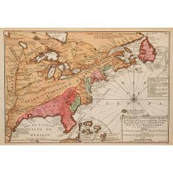
Le Canada, ou Nouvelle France la Florida, la Virginie, ? Misispi
Fine map of the eastern coast of North America. Engraved by Herman van Loon, a Dutch engraver active in Amsterdam, after 1686 in Paris. ¤
Date: Paris, 1705
Selling price: ????
Please login to see price!
Sold in 2009
Les estats du duché de Milan.
Map of the states of the Duchy of Milan, taken from "Atlas Curieux", printed in Paris.
Date: Paris, 1705
Selling price: ????
Please login to see price!
Sold in 2009
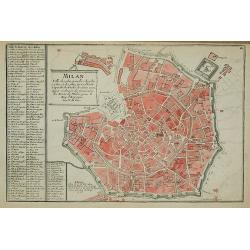
Milan
Map of Milan, taken from "Atlas Curieux", printed in Paris.
Date: Paris, 1705
Selling price: ????
Please login to see price!
Sold in 2012
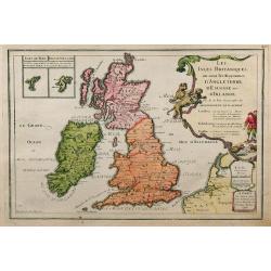
Les Isles Britanniques, ou sont les Royaumes d'Angleterre, d'Ecosse et d'Irlande.
This finely engraved map of the British Isles also has some detail of the adjacent French coast. The Fero and the Shetland Islands are included in small insets. Unusually...
Date: Paris, 1705
Selling price: ????
Please login to see price!
Sold in 2009
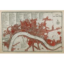
Plan des Villes de Londres et de Westminster et de leurs Faubourgs avec le Bourg de Southwark.
A rare engraving of London at the turn of the 17th/18th centuries engraved by C Inselin, stretching from Westminster Abbey in the west to Mile End in the east. A 113 poin...
Date: Paris, 1705
Selling price: ????
Please login to see price!
Sold in 2011
Le Sund ou Detroit du Sond.
Map of the Baltic sea, from "Atlas Curieux", printed in Paris.
Date: Paris, 1705
Selling price: ????
Please login to see price!
Sold in 2012
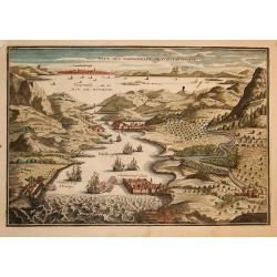
Veue des dardanelle s de Constantinople
Interesting miniature bird's-eye view shows the strategic strait between the Aegean Sea to the Sea of Marmara with Constantinople in the background. Nicolas de Fer held t...
Date: Paris, 1705
Selling price: ????
Please login to see price!
Sold in 2009
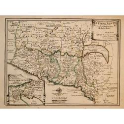
La Terre Sainte..
Decorative and detailed map of the region covering present-day Israel and Jordan and in the inset at left under a part of Egypt. The map shows the Holy Land divided among...
Date: Paris, 1705
Selling price: ????
Please login to see price!
Sold in 2009
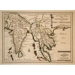
Les Vrays Indes dits Grands Indes ou Indes Orientales
Striking map of India and the Malaysian Peninsula, showing excellent detail throughout. From De Fer's Atlas Curieux. Nice wide margins and decorative cartouche.
Date: Paris, 1705
Selling price: ????
Please login to see price!
Sold in 2009
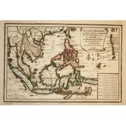
Les Isles Philippines
Striking map of the East Indies. From De Fer's Atlas Curieux. Nice wide margins and decorative cartouche.
Date: Paris, 1705
Selling price: ????
Please login to see price!
Sold in 2009
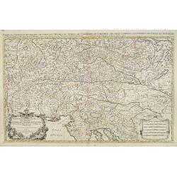
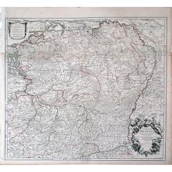
Partie du cercle d'Austriche, ou sont les duche's de Stirie, de Carinthie, de Carniole. . .
Very large map showing part of Northern Italy, Croatia, Austria and Slovenia. The map is fully and richly engraved. Large and extremely decorative cartouche with angels, ...
Date: Amsterdam, c.1705
Selling price: ????
Please login to see price!
Sold in 2010
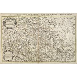
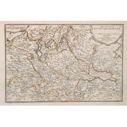
Etats de la Couronne de Boheme qui comprennent le Royaume de Boheme . . .
Extensive map centered on the rivers Elbe and Oder with Prague, including the eastern part of Germany and a part of Poland. The map is fully and richly engraved. Large an...
Date: Amsterdam, c.1705
Selling price: ????
Please login to see price!
Sold in 2023
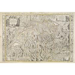
La Suisse divisée en ses treze cantons.
Very large map of Switzerland, ornated with a rococo title cartouche. 24 coats of arms along the left and right margin and another 9 coats of arms in lower left. Boundari...
Date: Amsterdam, c.1705
Selling price: ????
Please login to see price!
Sold in 2009
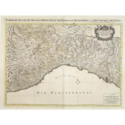
Partie du Duché de Milan la principauté de Piémont le Montferrat et la republique de Genes. . .
Very large map of the Duchy of Milan, including towns of Nice, Monaco, Turin, Milan, Genoa, Massa. With a sub title along upper margin. A first state, without with lines ...
Date: Amsterdam, c.1705
Selling price: ????
Please login to see price!
Sold in 2012
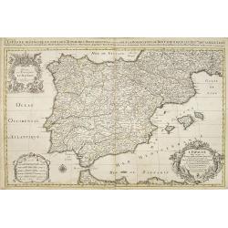
L'Espagne divisée en tous ses royaumes et Principautés. . .et sous la couronne de Portugal. . .
Very large map of Spain and Portugal, including the Balearic Islands Majorca, Minorca and Ibiza, ornated with a rococo title cartouche. A first state, without with lines ...
Date: Amsterdam, c.1705
Selling price: ????
Please login to see price!
Sold in 2011
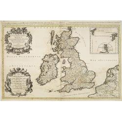
Les Isles Britanniques qui contiennents les- Royaumes, d' Angleterre, Escosse, et Irland.
Large scale map of England, Scotland and Ireland. To the left inset map of Shetland and Orkney Islands. A first state, without with lines of latitude and longitude. Extre...
Date: Amsterdam, c.1705
Selling price: ????
Please login to see price!
Sold in 2020
La Flandre espagnole, et la Flandre hollandoise ...
Detailed map of Flanders distinguishing the part in the past under Spanish domination from that under Dutch domination, from De Fer's Atlas Curieux.Showing Bruges, Gand, ...
Date: Paris, 1705
Selling price: ????
Please login to see price!
Sold in 2009
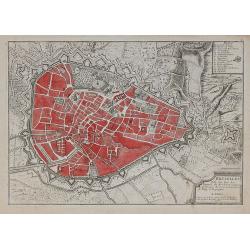
Bruselles ...
Map of Brussels from De Fer's Atlas Curieux.
Date: Paris, 1705
Selling price: ????
Please login to see price!
Sold in 2010
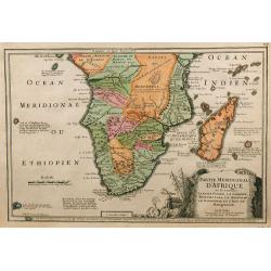
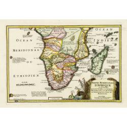
Partie Meridionale d'Afrique ...
Map of southern Africa, engraved by C. Inselin, from De Fer's Atlas Curieux.
Date: Paris, 1705
Selling price: ????
Please login to see price!
Sold in 2009
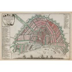
Amsterdam, Fameux port de mer.
Plan of Amsterdam, engraved by Van Loon, from De Fer's Atlas Curieux.
Date: Paris, 1705
Selling price: ????
Please login to see price!
Sold in 2010
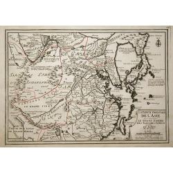
La partie orientale de L'Asie ou se trouvent le Grand Empire des Tartares chinois ...
The map includes China, an elonged Korea and the islands of Taiwan and Japan. Hokkaido is curiously shown as an Asian peninsula. Taiwan labeled: Isle Formosa ou Bel-Isle ...
Date: Paris, 1705
Selling price: ????
Please login to see price!
Sold in 2009
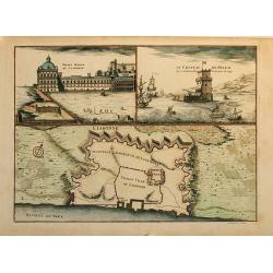
Lisbonne
This sheet combines a bird's-eye plan of the fortifications of Lisbon with two finely engraved views. At left is the "Palais Royal de Lisbonne" and at right &qu...
Date: Paris, 1705
Selling price: ????
Please login to see price!
Sold in 2010
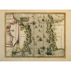
Coste d Andalousie et D álgarve
Nice map of the street of Gibraltar with Gibraltar at left and the African coast at right with the cities Ceuta (Spain) and Tanger (Marocco).The map has an inset at left ...
Date: Paris, 1705
Selling price: ????
Please login to see price!
Sold in 2009
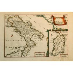
Le Royaume de Naples.
Nice map of the Southern part of Italy with also a part of Sicily and an inset of Sardinia.
Date: Paris, 1705
Selling price: ????
Please login to see price!
Sold in 2010
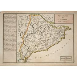
Principaute de Catalogne
A simply engraved map of the Spanish region of Catalonia depicting the Mediterranean coastline from the French border near Cadaques, southwest through Barcelona to the de...
Date: Paris, 1705
Selling price: ????
Please login to see price!
Sold in 2009
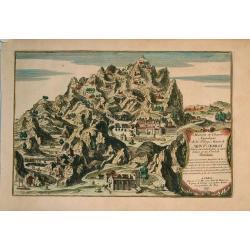
Maison et chambre .. Mont Serrat..Barcelone.
Nice view at the mountain Mont-Serrat close to Barcelona.
Date: Paris, 1705
Selling price: ????
Please login to see price!
Sold in 2009
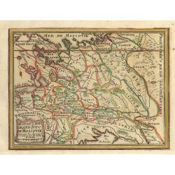
Estats du Grand Duc de Moscovie.
Small map of a part of Rusland.
Date: Paris, 1705
Selling price: ????
Please login to see price!
Sold in 2009
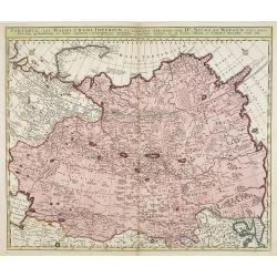
Tartaria, sive magni Chami Imperium ex credendis amplissimi viri Nicolai Witsen. . .
This map is particularly significant for depicting Russia, Siberia, and parts of Chinese Tartary, taken from the great six-sheet map by Nicolas Witsen, 1687. The importan...
Date: Amsterdam, 1705
Selling price: ????
Please login to see price!
Sold in 2010
Veue des Dardanelles de Constantinople.
Attractive birds eye view of Hellespont in Dardanelles Strait, fortifications and the city of Istanbul in the background. From "L'atlas curieux, ou Le monde réprés...
Date: Paris, 1705
Selling price: ????
Please login to see price!
Sold in 2011
Carte de Brabant.
Guillaume del'Isle map of Brabant region of Belgium and the Netherlands.
Date: Paris, 1705
Selling price: ????
Please login to see price!
Sold in 2010
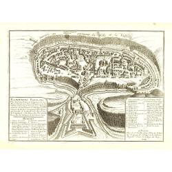
Kamieniec Podolski Ville forte des Estats de pologne et de la Haute Podotie. . .
Uncommon bird's eye view of the city of Kamianets-Podilskyi, located in western Ukraine. The print has in the lower left corner an explanatory panel with numbered (1-10) ...
Date: Paris, 1705
Selling price: ????
Please login to see price!
Sold in 2010
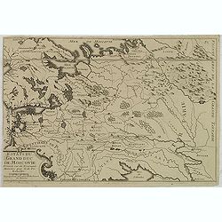
Estats du Grand Duc de Moscovie. . .
Lovely small map of Russia, Poland and reaching in the south to the Ukraine with Kiev. From De Fer's Atlas Curieux . . .
Date: Paris, c.1705
Selling price: ????
Please login to see price!
Sold in 2020
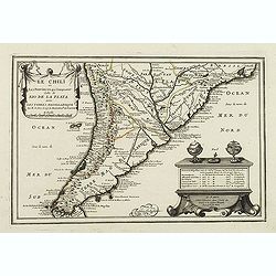
Le Chili et Les Provinces qui Composent Celle de Rio De La Plata avec Les Terres Magellanique. . .
Somewhat uncommon map of the southern part of South America, showing excellent detail along the River Plate and the Pacific Coast to the Andes mountains. Two globes and a...
Date: Paris, 1705
Selling price: ????
Please login to see price!
Sold in 2011
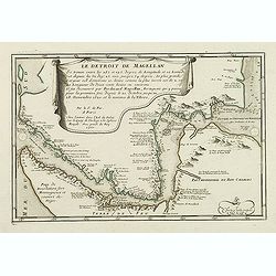
Le Detroit De Magellan . . . Se trouve . . . Il fut decouvert par Ferdinand . . .
Somewhat uncommon map of the Straits of Magellan, showing soundings, place names and other details in the passage through the Strait. Engraved by the master engraver Inse...
Date: Paris, 1705
Selling price: ????
Please login to see price!
Sold in 2011
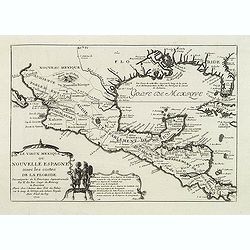
Le vieux Mexique ou nouvelle Espagne. . .
Detailed and important map of Mexico and Central America. The 'Atlas Curieux' was published in parts at first, and then as a complete entity in 1705.
Date: Paris, 1705
Selling price: ????
Please login to see price!
Sold in 2011
Carte du gouvernement de l'Amerique.
A double page map including a fine map of America, with California as an island with indented northern coastline. Lots of text and four insets of four governments of the ...
Date: Amsterdam, 1705
Selling price: ????
Please login to see price!
Sold in 2011
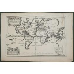
MAPPE-MONDE ou CARTE UNIVERSELL
An attractive map on the Mercator projection which has a number of interesting features. California is shown as an Island and New Guinea is joined to the mainland of Aust...
Date: Paris, 1705
Selling price: ????
Please login to see price!
Sold in 2015
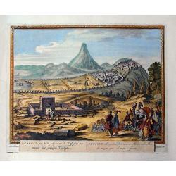
Derbent, een stadt gelegen aen de Kaspische Zee / Derbent, Atropatiae, sive Minoris Mediae urbs...
Rare view of Derbent the southern-most city in Russia, located near the Caspian Sea, supposedly the oldest city in Russia. Detailed and decorative view with numerous figu...
Date: Amsterdam, c1705
Selling price: ????
Please login to see price!
Sold in 2011
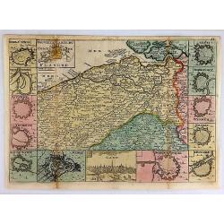
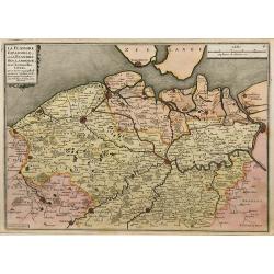
Nouvelle Carte Du Comte de Flandre.
An interesting map of Flanders first drawn by Daniel de la Feuille in 1706. A detailed map of the county of Flanders stretching from Dunkirk to the Schelde estuary. This ...
Date: Paris, 1706
Selling price: ????
Please login to see price!
Sold in 2018
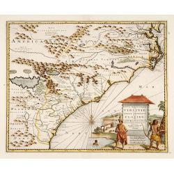
Partie Meridionale de la Virginie et la .. Floride..
Uncommon map of Virginia and the Carolinas.
Date: Amsterdam 1706
Selling price: ????
Please login to see price!
Sold

