Browse Listings
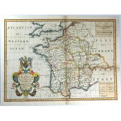
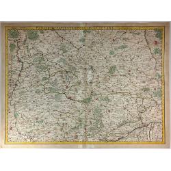
New Map of France Shewing its Principal Divisions, Chief Cities, Townes, Ports, Rivers, Mountains &c. Dedicated to His Highness William Duke of Gloucester....
A striking map of France divided into its provinces, including details such as mountains. The cartouche is splendid, and it includes the Gloucester coat of arms, fruit an...
Date: Oxford, 1703
Selling price: ????
Please login to see price!
Sold in 2016
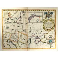
A New Map of Sarmatia Europaea Pannonia and Dacia...
A striking map of the land of ancient Sarmatia, Pannonia, and Dacia, extending from Hungary through the Ukraine. The cartouche is splendid, it includes the Gloucester coa...
Date: Oxford, 1703
Selling price: ????
Please login to see price!
Sold in 2017
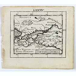
Tartaria Crimea.
A lovely miniature map of the region of Crimea. For such a small map it renders a wealth of detail, with mountains, forests, river, towns, cities all engraved in some det...
Date: Ulm, c 1703
Selling price: ????
Please login to see price!
Sold in 2016
A mapp of the Cape of Goodhope with its true Situation.
Very fine decorative map of Cape of Good Hope. From the book "A Collection of Voyages and Travels" by J. Churchill and the map came from the part containing the...
Date: London, Printed for A. and J. Churchill, 1703
Selling price: ????
Please login to see price!
Sold in 2016
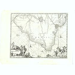
Brasilia.
A very fine and decorative map of Brazil. From the book "A Collection of Voyages and Travels" by Churchill, the map came from the section containing a descripti...
Date: London, Printed for A. and J. Churchill, 1703
Selling price: ????
Please login to see price!
Sold in 2017
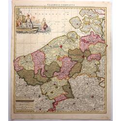
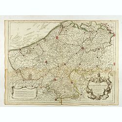
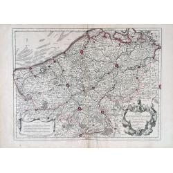
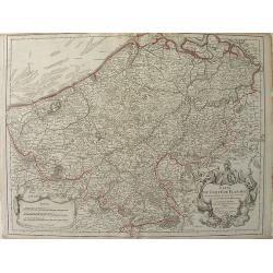
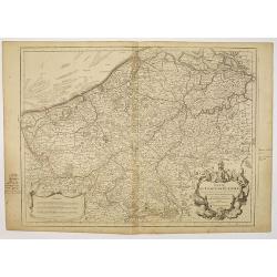
Flandriae Comitatus.
A scarce map of Belgium and neighbouring regions. With a decorative allegorical cartouche, with coat of arms, putti and queen. Published in Atlas Contractus Sive Mapparum...
Date: Amsterdam, 1703
Selling price: ????
Please login to see price!
Sold in 2018
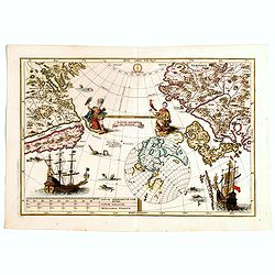
Tantum distamus ap invicem.
A map from the series of maps by the Jesuit mathematician. The map is centered on the Pacific Ocean between Asia and North America. It is an illustration of an uncommon p...
Date: Munich, 1703
Selling price: ????
Please login to see price!
Sold in 2018

Prospetto dell'anfiteatro Flavio . . . / Prospetto di Tutto l'Anfiteatro intiero . . . / Pianta dell' divisa nelli suoi / Spaccato, e veduta interiore dell' Anfiteatro.
Monumental engraving showing the Colloseum in Rome, in its setting, with below a ground-plan and elevation. Engraved and drawn by Alessandro Specchi (1668-1729), an engra...
Date: Rome, 1703
Selling price: ????
Please login to see price!
Sold in 2025
Representation Vonder Stadt Poltoski nebst der Action so geschehen zwischen Ihro Konichg. Maij. von Schweden unter eigene Hohe Commando, und Ihro Koniglg. Maij: von Pohln uner Commando des Feldt Marschal Steinau. . .
A rare print depicting the Battle of Pultusk, approximately 40 miles north of Warsaw, on April 21, 1703 during the Great Northern War.A very rare view--we are not able to...
Date: ca. 1703
Selling price: ????
Please login to see price!
Sold
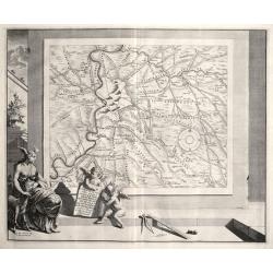
Superior Burgundiae Comitatus Vulgo la Franche Comte. . .
A detailed map of Upper Burgundy and its contiguous regions. Bottom right is a beautiful title cartouche featuring three putti.Gerard Valk (1652–1726) and his son Leona...
Date: Amsterdam, 1703
Selling price: ????
Please login to see price!
Sold in 2018
Superior Burgundiae Comitatus; Vulgo La Franche Comte.
A detailed map of Upper Burgundy and its contiguous regions. Bottom right is a beautiful title cartouche featuring three putti.Gerard Valk (1652–1726) and his son Leona...
Date: Amsterdam, 1703
Selling price: ????
Please login to see price!
Sold in 2018
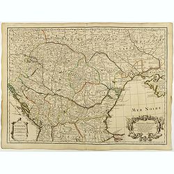
Carte de la Hongrie et des pays qui en dependoient autrefois. . .
Map of Hungary and the Balkans with the address : Chez l’Auteur sur le Quai de l’Horloge avec Privilege du Roy pour 20 ans, 1703. Lower right, Renard’s imprint is e...
Date: Paris, 1703
Selling price: ????
Please login to see price!
Sold in 2018
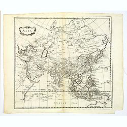
Asia.
A detailed map of Asia from his Heylyn's "Cosmographie". The map includes good detail through South East Asia and the islands in the Indian Ocean. It is embelli...
Date: London, 1703
Selling price: ????
Please login to see price!
Sold in 2019
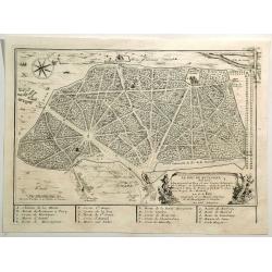
Le Bois de Boulagne.
A bird’s-eye view of Le Bois de Boulogne in Paris, detailed with paths, walls, trees, buildings, and a compass rose. It features a decorative title cartouche. Nicolas d...
Date: Paris, 1703
Selling price: ????
Please login to see price!
Sold in 2019
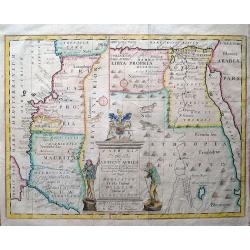
A new map of the north part of Antient Africa, shewing the chiefe people, cities, towns, rivers, and mountains in Mauritania, Numidia, Africa Propria, Libya Propria, and Egypt...
Ancient North Africa in two parts, the left portion shows Morocco to Cyrenaica (Libya), and is oriented to the east; the right portion from Cyrenaica to the Red Sea, orie...
Date: London, c1704
Selling price: ????
Please login to see price!
Sold in 2013
Le Royaume de Hongrie Divise en Haute et Basse.
Coronelli's scarce map of Hungary & Serbia published by Nolin. The huge 45 cm. cartouche includes the title, scale and advertising by Nolin of his maps. It depicts th...
Date: Paris, 1704
Selling price: ????
Please login to see price!
Sold in 2014
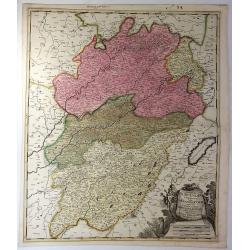
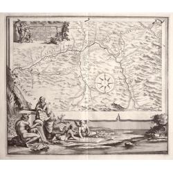
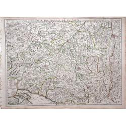
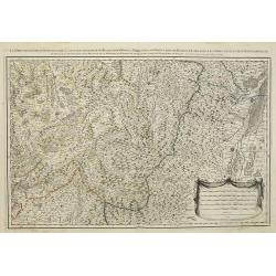
Partie Meridionale de la Souabe.
Very detailed hand-colored, copperplate map of Swabia in Germany and Switzerland. Includes the Danube River and the cities of Nuremberg, Augsburg, Ulm, Marchdorf etc. Als...
Date: Paris, 1704
Selling price: ????
Please login to see price!
Sold in 2016
\'Urbis cum vicis seu Pagis adiacentibus Descriptio Dissertationi III de Aq. et Aqued et Aqued Veteris Romae Praemissa, authore Raph. Fabretto Gasp. f, Urbinate\'. by Jan van Vianen
Rare copper engraving map of Rome , that shows the water supply of Rome and its aqueducts.Engraved by Jan van Vianen after Jan Goeree published by Francois Halma in Amste...
Date: Amsterdam, 1704
Selling price: ????
Please login to see price!
Sold in 2014
PARTIS LAT II. A. ROMA. LABICUM. USQUR DESCRIPTO DESSERTATIONI LIDE AQUIS ET AQUAE DUCTIBUS VETERIS ROMAE PRAEMISSA authore Raph Fabretto Gasp f, Urbinate\'.by Jan van Vianen
Rare copper engraving map of Rome, that shows the water supply of Rome and its aqueducts, to the South with two beautifully ornate cartouche. Engraved by Jan van Vianen a...
Date: Amsterdam, 1704
Selling price: ????
Please login to see price!
Sold in 2014
REGION IS INTER TIBUR, CARSEOLOS. ET. SUBLACUM DESCRIPTIO DISSERTATIONI. DE AQUIS ET. AQUAAEDUCTIBUS VETERIS ROMAE PRAEMISSA authore Raph Fabretto Gasp f, Urbinate\'.by Jan van Vianen
Rare copper engraving from Tibur (Tivoli) and the water supply for Rome with two beautifully ornate cartouche.Engraved by Jan van Vianen after Jan Goeree published by Fra...
Date: Amsterdam, 1704
Selling price: ????
Please login to see price!
Sold in 2013
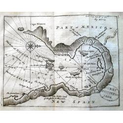
UNTITLED (Gulf of Nicoya)
Scarce chart of the Gulf of Nicoya (Costa Rica), from the account of William Dampier: "A voyage round the world..." The map is probably done by Moll. It shows ...
Date: London, ca. 1704
Selling price: ????
Please login to see price!
Sold in 2013
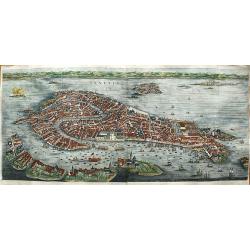
Venetia.
First state of this very large bird's-eye town view of Venice which can be considered the most beautiful and accurate of the XVII century.Engraved in 1670 by Julius Milhe...
Date: Amsterdam, 1704
Selling price: ????
Please login to see price!
Sold in 2020
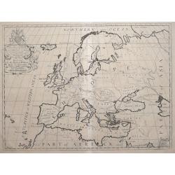
A New Map of Europe, According to the Present General Divisions, and Names of its Countries together with their Capital Cities Chief Rivers Mountains &c.
Drawn by Edward Wells engraved by M. Burg. An attractive and decorative early map of Europe from the beginning of the 18th Century. This map was part of an atlas dedicat...
Date: London, 1704
Selling price: ????
Please login to see price!
Sold in 2016
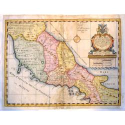
A New Map of Latium, Etruria and as Much of Ancient Italy as Lay Between Gallia Cis-Alpina and Graecia Magna.
A fine copper engraved map of ancient Italy. Lovely, large title cartouche with the coat of arms of William, Duke of Gloucester, son of Queen Anne, to whom the map was de...
Date: London, 1704
Selling price: ????
Please login to see price!
Sold in 2015
Veue de Sebenico... /Plan de Sebenico.../Port de Sebenico...
Rare large sheet with three maps/views of Šibenik in Croatia. The large panorama view shows the harbour with several sailing ships, the detailed city in the background, ...
Date: Amsterdam, 1704
Selling price: ????
Please login to see price!
Sold in 2015
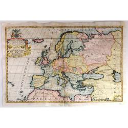
A New Map of Europe, According to the Present General Divisions, and Names of its Countries together with their Capital Cities Chief Rivers Mountains &c..
Drawn by Edward Wells engraved by M. Burg. An attractive and decorative early map of Europe from the beginning of the 18th Century. This map was part of an atlas dedicate...
Date: London, 1704
Selling price: ????
Please login to see price!
Sold in 2015
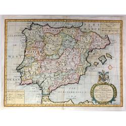
A New Map of Present Spain & Portugal, Shewing Their Principal Divisions, Chief Cities, Townes, Ports, Rivers, Mountains & c. Dedicated to his Highness, William, Duke of Gloucester
Drawn by Edward Wells and engraved by R. Spofforth. An attractive and decorative early map of Spain & Portugal from the beginning of the 18th Century.This map was pa...
Date: London, 1704
Selling price: ????
Please login to see price!
Sold in 2015
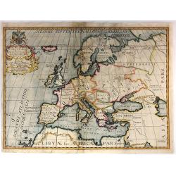
A New Map of Europe According to its Ancient General Divisions and Names of its Countries together with Their Chief Cities, Rivers, Mountains & c. Dedicated to his Highness, William, Duke of Gloucester
Drawn by Edward Wells and engraved by M. Burg. An attractive and decorative early map of Europe from the beginning of the 18th Century.This map was part of an atlas dedic...
Date: London, 1704
Selling price: ????
Please login to see price!
Sold in 2015
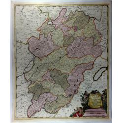
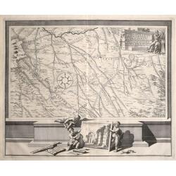
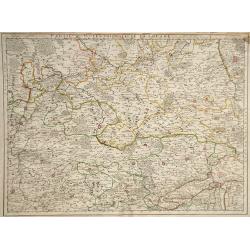
Partie Septentrionale de la Souabe.
Map of Swabia, Germany, one of the ten circles of the Holy Roman Empire. It covers the northern portion of the Empire from Nuremberg south to Wertingen and from Stuttgart...
Date: Paris, 1704
Selling price: ????
Please login to see price!
Sold in 2018
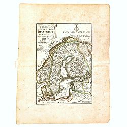
Suède, Norvège et Dannemarck.
An interesting small map of Scandinavia by Nicolas de Fer. From his rare "Petit et Nouveau Atlas". The first edition was published in 1697 and was republished i...
Date: Paris, 1704
Selling price: ????
Please login to see price!
Sold in 2017
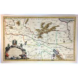
Galatia Cujus Populi Tolistobogi, Tectosages, Trocmi Mox Provincia sub Romani
This striking map by Nicolas Sanson is of northern Turkey, and is centreed on Ancyra (Ankara). It illustrates the provinces inhabited by the three Celtic tribes that migr...
Date: Amsterdam, 1704
Selling price: ????
Please login to see price!
Sold in 2016

Grande Tartarie.
A lovely small map of Greater Tartary in Russia, and on into Asia, including Tibet, Usbec, China and Korea. Each region depicted is with a different outline color. A smal...
Date: Madrid, ca. 1696-1704
Selling price: ????
Please login to see price!
Sold in 2017
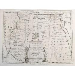
A new map of the north part of Ancient Africa, shewing the chiefe people, cities, towns, rivers, and mountains in Mauritania, Numidia, Africa Propria, Libya Propria, and Egypt...
Ancient North Africa in two parts, the left portion shows Morocco to Cyrenaica (Libya), and is oriented to the east; the right portion from Cyrenaica to the Red Sea, orie...
Date: London, ca.1704
Selling price: ????
Please login to see price!
Sold in 2017
Orbetelli, Ville du Sienois en Toscane Assiegee par les Francois en 1646. Ils Furent Contraints de Lever le Siege.
A view of Orbetello, under siege by the French by Pierre Mortier. Orbetello is a town and commune in the province of Grosseto (Tuscany), Italy. A stunning birds-eye persp...
Date: Amsterdam, 1704
Selling price: ????
Please login to see price!
Sold in 2021
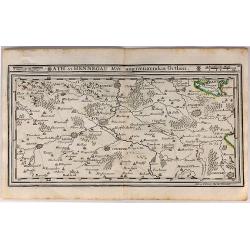
Ath in Hennegau Mitt Angeraenzenden Orthen.
An interesting map of the district of Ath, one of seven administrative districts within the Belgian province of Hainaut (southwest part). It was produced by Gabriel Boden...
Date: Augsburg, 1704
Selling price: ????
Please login to see price!
Sold in 2018
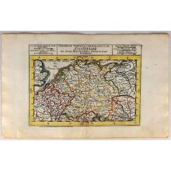
S. Imperium Romano Germanicum Deutschland.
A fine engraved map by Bodenehr, published in Augsburg in 1704. This is a 313 year old antique map of Germany in the days of Imperial Rome, when it comprised numerous lit...
Date: Augsburg, 1704
Selling price: ????
Please login to see price!
Sold in 2018
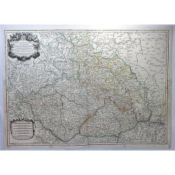
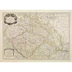
Estats de la Couronne de Boheme. . .
A large decorative map of Bohemia, with Silesia, Lusatia and Moravia. (currently the Czech Republic) centered on Prague, with an elaborate title cartouche featuring two h...
Date: Paris, 1704
Selling price: ????
Please login to see price!
Sold in 2018
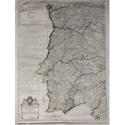
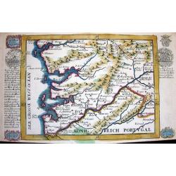
Royaume de Portugal et Partie D'Espagne Dresse sur des Memoires Envoyez de Lisbonne et de Madrid.
Very large map of Portugal (and part of Spain) by Besson, Geographer to the King of France. It was published in Paris in 1704. The map features a decorative title carto...
Date: Paris , 1704
Selling price: ????
Please login to see price!
Sold in 2018
Carte du Comté de Flandre. . .
Map of Flanders, with the address : Chez l’Auteur sur le Quai de l’Horloge (address erased after Horloge). Avec privilege pour vingt ans, 1704." Guillaume de l'I...
Date: Paris, 1704
Selling price: ????
Please login to see price!
Sold in 2022
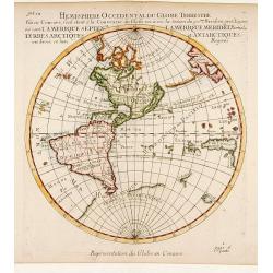
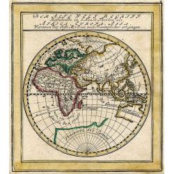
Hemisphere Superieur du Globe Terrestre..
Rare map of Western Hemisphere shown in reverse, but text printed normally. World from internal viewpoint. California with indented northern coast. Terre de Jesso to Nort...
Date: Paris 1704
Selling price: ????
Please login to see price!
Sold
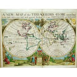
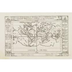
A New Map of the Terraqueous Globe According to the Latest Discoveries ..
Title: A New Map of the Terraqueous Globe According to the Latest Discoveries and most General Divisions of it into Continents and Oceans.An exceptional world map from 'A...
Date: London, 1704
Selling price: ????
Please login to see price!
Sold
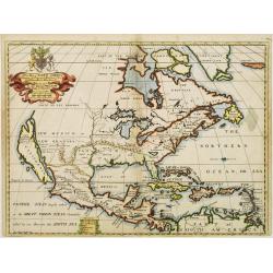
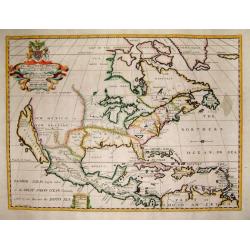
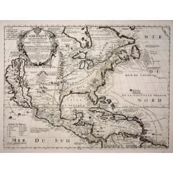
A New Map of North America Shewing its Principal Divisions, Chief Cities, Townes, Rivers, Mountains & c.
A boldly engraved map of North America, showing California as an island. This is a state 4. California as New Abion discovered by Sir Francis Drake Anno 1577 . Traci now ...
Date: London, 1704
Selling price: ????
Please login to see price!
Sold in 2018
A New Map of North America
Title: 'A New Map of North America Shewing its Principal Divisions, Chief Cities, Townes, Rivers, Mountains & c.'. A rare and interesting map of North America. Alth...
Date: London, 1704
Selling price: ????
Please login to see price!
Sold
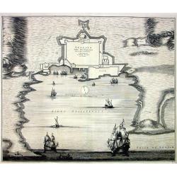
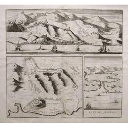
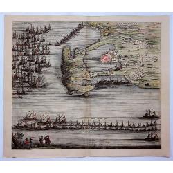
Spalato. Ville des Venetiens,...
Large decorative view of the forts and harbour of Split in Croatia. A few roads, buildings and hills are shown. Decorated with multiple large sailing ships, a distance sc...
Date: Amsterdam, c1704
Selling price: ????
Please login to see price!
Sold
![[Lot af 6] maps of southern Germany](/uploads/cache/18164-250x250.jpg)
[Lot af 6] maps of southern Germany
[Lot of 6] maps Germany- Exactissima Tabula Sedis Belli Palatinatus ad Rhenum, Vormaciensis et Spirensis Episcopatus….- Le Cours du Rhin depuis Worms jusqu a Bonne…....
Date: Paris, 1704
Selling price: ????
Please login to see price!
Sold in 2022
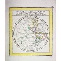
Der neuen West Begriff...
Scarce German miniature map of the Western Hemisphere showing California as an Island, a partial coast of New Zealand and a misshaped South America. The western coast of ...
Date: Augsburg 1704
Selling price: ????
Please login to see price!
Sold
AVENIO Vulgo AVIGNON.
Bird-eye view of Avignon. From the rare town book by Mortier.
Date: Amsterdam 1704
Selling price: ????
Please login to see price!
Sold
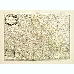
Estats de la couronne de Boheme qui comprennent le Royaume de Boheme..
Decorative map of Czech Republic with a nice title cartouche. Engraved by Cordier and prepared by N. Sanson. With the address "les grands Augustins, aux a globes&quo...
Date: Paris 1704
Selling price: ????
Please login to see price!
Sold
Estats de la Couronne de Boheme qui comprennent le Royaume de Boheme, le Duché de Silesie?
Centered on Prague. Engraved by Cordier.
Date: Paris, 1704
Selling price: ????
Please login to see price!
Sold
Die Süd-West Cüste von Gallicien.
Very decorative map from Bodenehr's "Atlas curieux" published in Augsburg. The detailed map shows the area around Vigo in Gallicia in north-west Spain and inclu...
Date: Augsburg, c1704
Selling price: ????
Please login to see price!
Sold
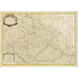
Estats de la couronne de Boheme qui comprennent le Royaume de Boheme..
Decorative map of Czech Republic, southwestern part of Poland and eastern parts of Germany with a nice title cartouche.Engraved by Cordier and prepared by N. Sanson. With...
Date: Paris 1704
Selling price: ????
Please login to see price!
Sold
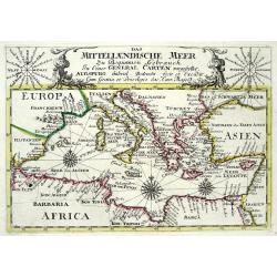
DAS MITTELLAENDISCHE MEER...
Very decorative copper-engraved map from Bodenehr's "Atlas curieux" published in Augsburg. Shows the Mediterranean Sea with many place names. Decorated with a...
Date: Augsburg, c1704
Selling price: ????
Please login to see price!
Sold
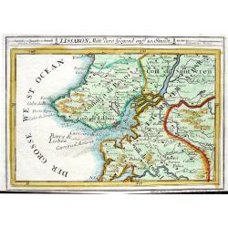
LISSABON MITT DERO GEGEND AUFF 10. STUNDT
Very decorative map from Bodenehr's "Atlas curieux" published in Augsburg. The detailed map shows the area around Lisbon/Lisboa with many towns and villages s...
Date: Augsburg, c1704
Selling price: ????
Please login to see price!
Sold
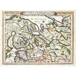
RUSSLANDS ODER MOSKOVIENS NORD-WEST THEIL...SCHWEDEN UND NORWEGEN...POLEN...
Very decorative map from Bodenehr's "Atlas curieux" published in Augsburg. The map shows parts of Norway, Sweden, Finland, the Baltic states and Russia in gre...
Date: Augsburg c1704
Selling price: ????
Please login to see price!
Sold in 2009
Carta Hydrographica oder algemeine Welt und Commercien Carte..
This map shows the World on a Mercator projection, with the title contained within a panel. Decorative scrollwork above and decorative panels to either side and below cat...
Date: Augsburg, 1704
Selling price: ????
Please login to see price!
Sold
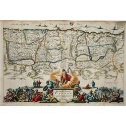
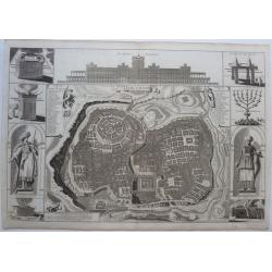
Het Beloofde Landt Canaan..
Title of the map: Het Beloofde Landt Canaan door wandelt van onsen Salichmaecker Iesu Christo, neffens syne Apostelen.Fine map of Israel with north oriented to right. Lar...
Date: Amsterdam, 1704
Selling price: ????
Please login to see price!
Sold
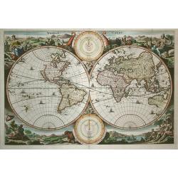
Werelt Caert. Orbis terrarum
Lovely double hemisphere map from a Dutch Bible. Title inside the surrounding allegorical representations of the continents, based on Visscher. CALIFORNIA IS AN ISLAND wi...
Date: Amsterdam 1704
Selling price: ????
Please login to see price!
Sold in 2009
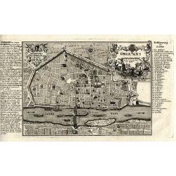
Orleans.
Superb copper-engraved city plan from Bodenehr's "Atlas curieux" published in Augsburg.
Date: Augsburg, c1704
Selling price: ????
Please login to see price!
Sold in 2012
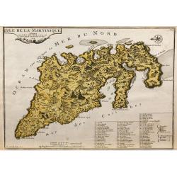
L'Isle de la Martinique.
Map of the island of Martinique, engraved by F.Starckman, from De Fer's Atlas Curieux.
Date: Paris, 1704
Selling price: ????
Please login to see price!
Sold in 2009
Der alte West Begriff...
Attractive German miniature map of the Eastern Hemisphere - the old World - extending from Iceland to Far East Asia and Australia. With some curious shaped areas. Austr...
Date: Augsburg, 1704
Selling price: ????
Please login to see price!
Sold in 2010
L'Amerique Septentrionale, ou la Partie Septentrionale des Indes Occidentales ou se Trouve le Canada ou Nouvelle France la Floride la Virginie les Isles Antilles le Nouveau Mexique et la Nouvele Espagne.
“Vincenzo Maria Coronelli’s large two-sheet ‘AMERICA SETTENTRIONALE,’ dated 1688, did not appear in an atlas until 1691, in the first edition of the ‘Atlante Ve...
Date: Paris, 1689-1704
Selling price: ????
Please login to see price!
Sold in 2013
Mappa Geographica Exactissima, Continens Imperatoris Haereditarium Dominium Silesiam, nec non eiusdem Provincias interiores Ducatus, Comitatus, Baronatus etc. edente Petro Schenck Cum Privilegio Ord. General. Holland et West Frisiae
Map of part of Poland and Germany. The region along the river Oder. Cracow in lower right corner. Prague in lower left. Copper engraving, hand colored in outline and wash...
Date: Amsterdam, 1704
Selling price: ????
Please login to see price!
Sold in 2015
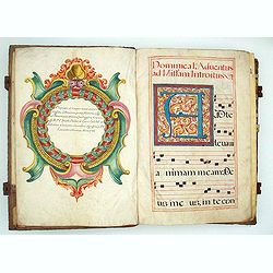
A gigantic Antiphoner in massive contemporaru binding.
A gigantic Antiphoner, about 2,5 feet high. It is certainly the biggest of these vast choir books we have handled for many years. MASSIVE CONTEMPORARY BINDING of wooden b...
Date: Spain, 1704
Selling price: ????
Please login to see price!
Sold in 2010
Carte du Comte de Flandre.
Guillaume de L'Isle map of Belgium, shows cities of Brugge and Antwerp.
Date: Paris, 1704
Selling price: ????
Please login to see price!
Sold in 2010
Partie Meridionale de la Souabe.
Guillaume del'Isle map of the region of Southern Germany, near the border of Switzerland.
Date: Paris, 1704
Selling price: ????
Please login to see price!
Sold in 2010
Partie Septentrionale de la Souabe.
Map of the Swabia region of Bavaria in Southern Germany, a very important historic and cultural region of Europe. Charlemagne's family is from the Swabia region, and as w...
Date: Paris, 1704
Selling price: ????
Please login to see price!
Sold in 2010
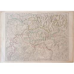
Le Cours du Rhin depuis Worms, jusqua Bonne, et Les Paysa Adjaces.
Map of the eastern Germany, showing the region surrounding the Rhine Rivers, or the Rhine Valley. Cities shown (from north to south) include Bonne, Cologne, Mainz, Frankf...
Date: Paris, 1704
Selling price: ????
Please login to see price!
Sold in 2010
Carte du Comte de Flandre Dressee Sur Differens Morceaux LevezSur Les Lieux Fixez Par Les Obfervations A Aftonomiques.
A map of Flanders by Guillaume De L'Isle depicting major cities such as Conde and Altervelt, and major river systems. In the bottom right hand corner lies a very detailed...
Date: Paris, 1704
Selling price: ????
Please login to see price!
Sold in 2010
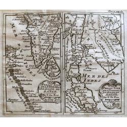
Presqu'Isle De L'Inde De Ca Le Golfe Du Gange/Presqu'Isle De L'Inde De La Le Golfe Du Gange.
Pair of maps, one of the Indian peninsula and Sri Lanka, and another of Southeast Asia, including Singapore.
Date: Paris, c.1704
Selling price: ????
Please login to see price!
Sold in 2012
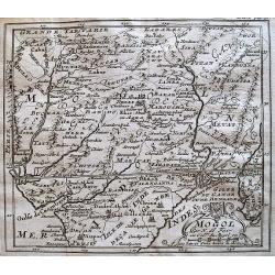
Mogol.
Detailed map of the Mughal Empire, which controlled much of South Asia by the early 18th century.
Date: Paris, c.1704
Selling price: ????
Please login to see price!
Sold in 2013
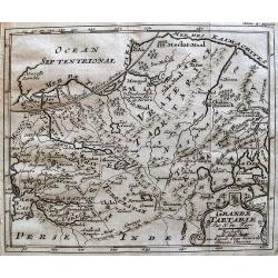
Grande Tartarie.
Map of Tartary covering present-day Asian Russia.
Date: Paris, c.1704
Selling price: ????
Please login to see price!
Sold in 2010
Carte du Comté de Flandre. . .
Map of Flanders. The publishers address in the title cartouche partly erased. Some manuscript annotations in brown pen and ink in the margin and in the map. Engraved by L...
Date: Paris, c.1704
Selling price: ????
Please login to see price!
Sold in 2010
Carte Du Diocese de Narbonne. . .
Finely detailed map of the Diocese of Narbonne, a Catholic Diocese that existed in southwestern France until the French Revolution, by Guillaume de L'Isle. A nice inset m...
Date: Paris, 1704
Selling price: ????
Please login to see price!
Sold in 2010
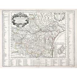
Les prevotez, senechaussee, et comte, qui font partie des Balliages de Vosges ou Mirecour . . .
Map of Vosges including the city of Epinal, Colmar.
Date: Paris, 1704
Selling price: ????
Please login to see price!
Sold in 2011
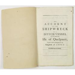
An account of the shipwreck of a Dutch vessel on the coast of the Isle of Quelpaert, together with the description of the kingdom of Corea. Translated out of French.
FIRST ENGLISH EDITION. A 26 page description extracted from the first edition of Churchill's "A Collection of Voyages and Travels: Some Now First Printed from Origin...
Date: London, 1704
Selling price: ????
Please login to see price!
Sold in 2011
Complete set of five Bible maps.
The Dutch so-called "Staten-Bijbels" were published from 1637 onwards. The printed bibles were allowed to embody outside the official Bible text but inside the ...
Date: Dordrecht, 1704
Selling price: ????
Please login to see price!
Sold in 2023
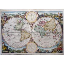
Werelt Caert. Orbis terrarum.
A beautiful double hemisphere world map. Surrounded by allegorical representations of the continents, based on the work of Visscher. Australia is partially mapped and the...
Date: Dordrecht, 1704
Selling price: ????
Please login to see price!
Sold in 2021
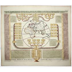
CARTE DU PREMIER PERIODE DU MONDE DEPUIS ADAM JUSQU'A MOISE OU L'ON VOIT LA CHRONOLOGIE. . .
A fascinating engraving depicting a map of the Old World surrounded and keyed to a Biblical genealogical family tree. Panels at side provide an historical timeline for th...
Date: Amsterdam, 1705
Selling price: ????
Please login to see price!
Sold in 2020
Cette Carte de Californie et du Nouveau Mexique . . .
A most important map, identifying by numerical code some 314 places in New Mexico, and showing in detail California as an island, although based on Sanson's monumental ma...
Date: Paris, 1705
Selling price: ????
Please login to see price!
Sold in 2020
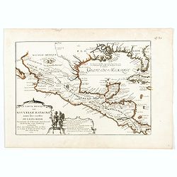
Le Vieux Mexique ou Nouvelle Espagne . . .
Attractive map covering the Gulf of Mexico through Central America also including parts of Cuba and Jamaica. It extends through Mexico to show the southern tip of Baja Ca...
Date: Paris, 1705
Selling price: ????
Please login to see price!
Sold in 2022