Browse Listings
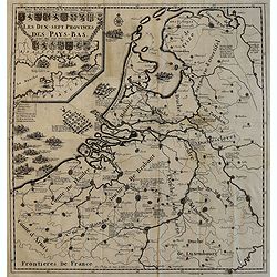
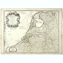
![Les Provinces Unies ou la Partie Septentrionale des Pays Bas . . . par le P. Coronelli . . . 1690 [together with] La partie Meridionale des Pays Bas connue sur le nom Flandre. . .](/uploads/cache/35670-250x250.jpg)
Les Provinces Unies ou la Partie Septentrionale des Pays Bas . . . par le P. Coronelli . . . 1690 [together with] La partie Meridionale des Pays Bas connue sur le nom Flandre. . .
Two attractive map of the northern and southern parts of the Low Countries. The northern part was produced by the Venetian cosmographer Vincenzo Coronelli when he was wor...
Date: Paris, 1701
Selling price: ????
Please login to see price!
Sold in 2015
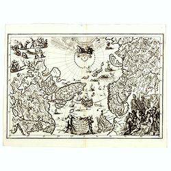
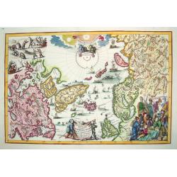
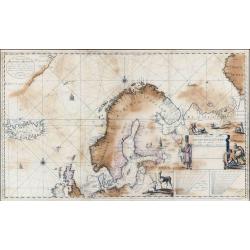
Regionum Circum Polarium Lapponiae Islandiae et Groenlandiae.
A highly decorative and scarce map of the Arctic regions on Canada, Scandinavia and Russia, along with the North Atlantic. Filled with images of sailing ships, sea monste...
Date: Munich, 1701
Selling price: ????
Please login to see price!
Sold in 2016
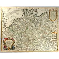
L'ALLEMAGNE, Dresse sur les Observations de Tycho Brahe, de Kepler, de Snellius....
This pleasant map shows Germany, as well as the Low Countries, Switzerland, Austria, parts of Poland and Hungary. Attractive ornamental cartouche with trumpet players, fl...
Date: Paris, 1701
Selling price: ????
Please login to see price!
Sold in 2016
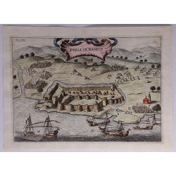
Presa di Namur.
A detailed, attractive, panoramic battle view of the siege of the Karaman fortification in Anatolia, Turkey, fought between the Naval Army of the Gand Duke of Tuscany, Co...
Date: Florence, 1701
Selling price: ????
Please login to see price!
Sold in 2023
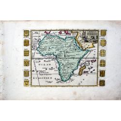
Africa Selou les Autheurs les plus Modernes.
A rare map of Africa. Very decorative. It shows a quite up-to-date Africa flanked with armorial shields for major nations. The cartouche depicts natives smoking and tradi...
Date: Paris, 1701
Selling price: ????
Please login to see price!
Sold in 2017
Provinces Unies des Pays Bas
A uncommon map of the XVII Provinces.
Date: Amsterdam 1701
Selling price: ????
Please login to see price!
Sold in 2018
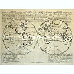
Mappe Monde pour connaitre les progrès et les conquestes les plus Remarquables des Provinces-Unies
Interesting world map related to the global Dutch commercial ventures of the VOC and WIC. Showing California as an island.
Date: Amsterdam, 1701
Selling price: ????
Please login to see price!
Sold in 2018
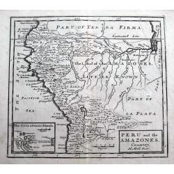
Peru and the Amazones Country.
Detailed copper engraved map showing parts of todays Peru, Ecuador, Bolivia, Brazil, Columbia, Chile and Argentina. From Quito until the mouth of the Amazonas. Includes a...
Date: London, ca. 1701
Selling price: ????
Please login to see price!
Sold in 2018
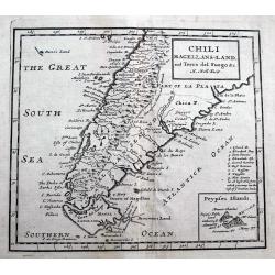
Chili Magellans-Land, and Terra del Fuego &c.
A detailed copper engraved map south of Paraguay with Chile, Argentina, Tierra del Fuego, Le Maire Strait, and a small tip of the Falkland Islands. Includes a curious 'Da...
Date: London, ca 1701
Selling price: ????
Please login to see price!
Sold in 2018
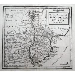
The Great Province of Rio de la Plata.
A detailed copper engraved map of parts of Brazil, Paraguay and Uruguay until Buenos Aires. Includes a curious Lake of Xarayes and the fictional Saxemberg Island.
Date: London, ca 1701
Selling price: ????
Please login to see price!
Sold in 2018
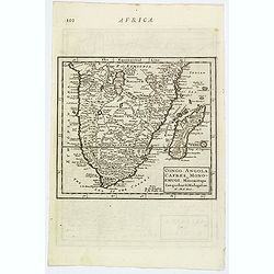
Congo, Angola, Cafres, Monoemugi, Monomotapa, Zanguebar & Madagascar.
The nice map that extends from Central Africa - Congo to Mombasa to the Cape of Good Hope. Herman Moll (fl.1678-1732). was a bookseller, geographer and engraver. A native...
Date: London, ca 1701
Selling price: ????
Please login to see price!
Sold in 2019
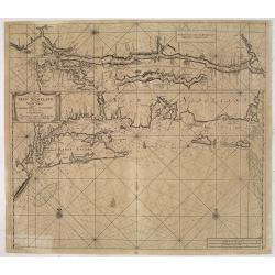
![Sea of Azov The Eastern Part of the Sea [usually known as] Palus Maeotis and now Called the Sea of Azov...(Vostochnaja chast' morja palus meotis i nyne nazyvaetsja azovskoe more...)](/uploads/cache/43912-250x250.jpg)
Sea of Azov The Eastern Part of the Sea [usually known as] Palus Maeotis and now Called the Sea of Azov...(Vostochnaja chast' morja palus meotis i nyne nazyvaetsja azovskoe more...)
Very rare and important chart of the eastern part of the Sea of Azov, the Kerch Strait and parts of the Black Sea. This important chart was compiled from measurements an...
Date: Moscow, Kremlin Armoury, 1701
Selling price: ????
Please login to see price!
Sold in 2019
Regionum Circum Polarium Lapponiae Islandiae et Groenlandiae...
A highly decorative and sought after map of the North Pole filled with images of sailing ships, sea monsters, hunting, whaling and exploration. This work provides cartogr...
Date: Munich, 1701
Selling price: ????
Please login to see price!
Sold
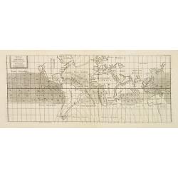
Tabula Totius Orbis Terrarum Exhibens Declinationes Magneticas, ad Annum 1700 composita ab Edmundo Halleyo simul cum Inclinationibus a Poundio observatis et Ventis Universalibus.
French publication of Halley's important chart demonstrating the variations of the compass, created by him in 1701. Though best known as the discoverer of the comet which...
Date: Paris c.1701
Selling price: ????
Please login to see price!
Sold
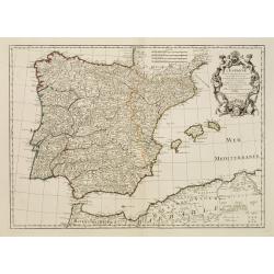
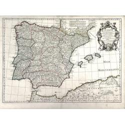
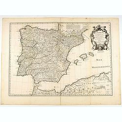
L'Espagne.
Beautiful map showing Spain and Portugal, the different Provinces ( Castille, Aragon, Andalousia..) and the North African coast. Decorative title cartouche.
Date: Paris, 1701
Selling price: ????
Please login to see price!
Sold
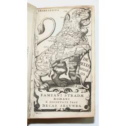
Famiani Strad Romani E Societate Jesu De Bello Belgico Decas Secunda
This popular history describes the war between the Low Countries and Spain between 1568 and 1648 from a pro-Spanish and pro-Catholic viewpoint. Famiamo Strada was a Jesui...
Date: Rome, 1701
Selling price: ????
Please login to see price!
Sold in 2008
L'Africa divisa nelle sue Parti secondo le piu moderne, relationis colle scoperte dell origine e corso del Niro
Famous two sheet Coronelli map of Africa. Second edition from 1701 which is unchanged since first edition in 1691. Many little elephants, lions and other animals filling ...
Date: Venice, 1701
Selling price: ????
Please login to see price!
Sold in 2008
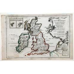
Les Isles Britanniques, ou sont les Royaumes d'Angleterre, d'Escosse et D'Ireland.
Map of the British Isles: England, Ireland and Scotland, each delineated through the use of different outline colors, from the atlas "Le Monde Dresse et Dedie Anosse...
Date: Paris, 1701
Selling price: ????
Please login to see price!
Sold in 2010
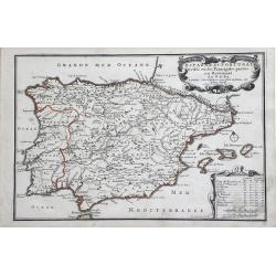
L'Espagne, dresse fur la Description qui en a ete faite par Rodrigo Mendez Sylva. . .
Finely detailed map Spain by Guillaume de L'Isle. Shows cities, villages, mountains and rivers. Also shown are the islands of Minorca, Mallorca and Ibiza and well as the ...
Date: Paris, 1701
Selling price: ????
Please login to see price!
Sold in 2010
Espagne et Portugal.
Small scale, detailed map of Portugal and Spain by French cartographer Nicholas de Fer. A decorative title cartouche is at the top right, and a small distance key is at t...
Date: Paris, 1701
Selling price: ????
Please login to see price!
Sold in 2010
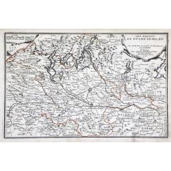
Les Estats du Duche de Milan. . .
Map of the duchy of Milan and surrounding regions. The territory of Milan, outlined in orange, was an independent state in northern Italy from 1395 to 1797, although an i...
Date: Paris, 1701
Selling price: ????
Please login to see price!
Sold in 2010
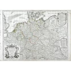
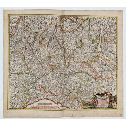
L'Allemagne Dressee sur les Observations de Tycho-Brahe de Kepler de Snellius sur celles de Messieurs de l'Academie Royale des Sciences
Finely detailed map of northwestern Europe including the countries of Northern France, Belgium, The Netherlands, Germany, Luxembourg, Switzerland, Northern Italy, Austria...
Date: Paris, 1701
Selling price: ????
Please login to see price!
Sold in 2010
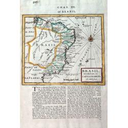
Brasil, divided into its Captainships.
Important map of Brazil when it was a Portuguese colony. It depicts the various captainships including Para, Maragnan, Siara, Rio Grande, Paraiba, Tamaraca, Pernambuco, S...
Date: London, 1701
Selling price: ????
Please login to see price!
Sold in 2019
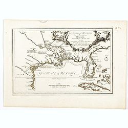
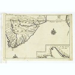
Les Costes aux Environs de la Riviere de Misisipi.
An historically important map of Florida and the Gulf Coast showing especially the estuary of the Mississippi in some detail, more or less correctly located.The locations...
Date: Paris, 1701
Selling price: ????
Please login to see price!
Sold in 2022
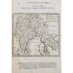
India or the Mogul's Empire.
A detailed map showing India, Sri Lanka, Tibet, Siam, Cambodia, etc. Names towns, rivers, and islands. With text below the map and on verso.
Date: London, ca 1701
Selling price: ????
Please login to see price!
Sold in 2020
L'Espagne . . .
Detailed map showing Spain and Portugal, the different Provinces ( Castille, Aragon, Andalousia..) and the North African coast. Decorative title cartouche.The rare Amster...
Date: Amsterdam, ca. 1701
Selling price: ????
Please login to see price!
Sold in 2022
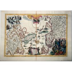
Nieuwe Paskaart Inhoudende t'Noorder deel van Europa sijnde seer Dienstigh voor de Groenlandse en Moscovise Scheepvaard.
A very large, exceptionally rare, early navigation chart of Scandinavia by van Keulen, with highly decorative hunting scenes. The chart is based on Mercator projection. G...
Date: Amsterdam, 1701
Selling price: ????
Please login to see price!
Sold in 2022
Regionum Circum Polarium Lapponiæ Islandiæ Et Groenlandiæ Novae Et Veteris Nova Descriptio Geographica.
This north polar projection map is a busy, decorative map, showing the North Pole, North America and the northwest of Europe and Asia, including Greenland, Lapland, the B...
Date: Munich, 1701
Selling price: ????
Please login to see price!
Sold in 2021
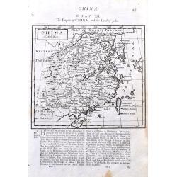
China.
A detailed copper engraved map of China including Taiwan and South Korea. Shows the Great Wall. With good details of towns, rivers, and islands. With interesting text abo...
Date: London, 1701
Selling price: ????
Please login to see price!
Sold in 2021
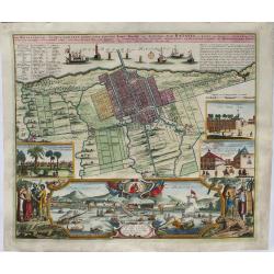
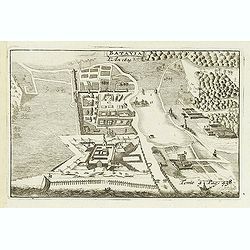
Der Hollaendisch-Ostindianischen Compagnie Weltberühmte Haupt-Handels und Niederlags-Stadt Batavia.
A truly beautiful map of Batavia, with a map of the city, two views of the city, a magnificent view of the harbor and a fine representation of the most important build...
Date: Neurenberg, 1701
Selling price: ????
Please login to see price!
Sold in 2021
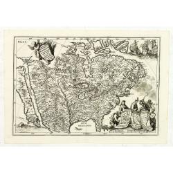
![[Lot of 5 maps of the Iberian peninsula / Belearics]](/uploads/cache/18379-(2)-250x250.jpg)
[Lot of 5 maps of the Iberian peninsula / Belearics]
Guillaume de l' Isle (1675-1724), Royal Geographer, was the most influential cartographer of the first quarter of the 18th century. ' Atlas de Géographie' (1700-12), pos...
Date: 1701
Selling price: ????
Please login to see price!
Sold in 2022
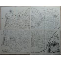
Kaart van de Ring van Putten, bestaande uit vier delen Caerte gemaeckt op ordre vande bovengenoemde heeren opperdijckgraeff en hoog heemraden des Ringhs van Putten
Wall map consisting of four separate maps, each measuring 50 x 63 cm. The Ring van Putten concerns the region south of Rotterdam, with cities such as Spijkenisse, Geervli...
Date: 1701
Selling price: ????
Please login to see price!
Sold in 2022
![Le Vieux Mexique ou NOUVELLE ESPAGNE avec les costes DE LA FLORIDE.[1st edition]](/uploads/cache/83258-250x250.jpg)
Le Vieux Mexique ou NOUVELLE ESPAGNE avec les costes DE LA FLORIDE.[1st edition]
The first edition of this interesting regional map of Florida, Texas, the Gulf Coast, the Southwest, Mexico and Central America, from the first edition of De Fer's Atlas ...
Date: Paris, 1702
Selling price: ????
Please login to see price!
Sold in 2020
Belli Typus in Italia, Victricis Aquilae Progressus in Statu Mediolanensi et Ducatu Mantuae
Original hand-colored engraved map. (sheet size 53 x 59 cm.). .
Date: Nuremberg, 1702
Selling price: ????
Please login to see price!
Sold in 2023
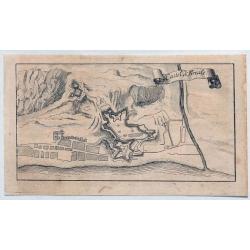
Castel di Finale.
Interesting 1702 engraved map featuring an aerial plan of Finale Ligure, Italy, with its fortifications.Published by Francis Maximilian Misson, originally François Maxim...
Date: London, 1702
Selling price: ????
Please login to see price!
Sold in 2020
![Canary, Azores+Cape Verde Islands. -ARCHIPELAGUS ATLANTICUS, CUM SUIS INSULIS CANARIIS, HESPERIDIBUS [CAPE VERDE] ET AZORIBUS.](/uploads/cache/85216-250x250.jpg)
Canary, Azores+Cape Verde Islands. -ARCHIPELAGUS ATLANTICUS, CUM SUIS INSULIS CANARIIS, HESPERIDIBUS [CAPE VERDE] ET AZORIBUS.
A very decorative map of Northwestern Africa and the Canary, Azores and Cape Verde Islands, with a large inset of Tenerife and Grand Canary Island. The richly decorated m...
Date: Munich, 1702
Selling price: ????
Please login to see price!
Sold in 2021
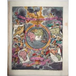
Globus Terraqueus Ecclesiastico Politicus In Suas Partes et Dominia Divisus.
This decorative print shows the hand of God holding the world suspended through a cross fixed on the North Pole. The surrounding skies are populated with cherubs, some of...
Date: Munich, 1702
Selling price: ????
Please login to see price!
Sold in 2021
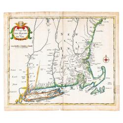
An Exact Mapp of New England and New York.
Recognized as the first 18th-century map of New England (Schwartz & Ehrenberg), this map was used to illustrate Cotton Mather's famous history of the Bay Colony, &quo...
Date: London: Printed for Thomas Parkhurst, 1702
Selling price: ????
Please login to see price!
Sold in 2023
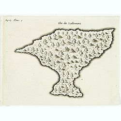
Isle de Ladrones.
Early map of the Mariana Islands (up to the early 20th century sometimes called Ladrones Islands, from Spanish Islas de los Ladrones meaning "Islands of Thieves"...
Date: Amsterdam, E. Roger, 1702
Selling price: ????
Please login to see price!
Sold in 2013
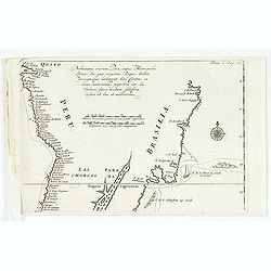
Pelineatis anarium Peru cujus Metropolis Lima : In qua vicarus Regis, Archie piscopusque . . . .
Uncommon map of the central part of South America with Peru, Brasil. Only coastal names.From a travel book describing the early Dutch voyages by René Augustin Constantin...
Date: Amsterdam, E. Rogers, 1702
Selling price: ????
Please login to see price!
Sold in 2016
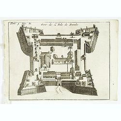
Fort de l'Isle de Banda.
Decorative print of the Dutch fortress on the island Banda.From a travel book deScribing the early Dutch voyages by René Augustin Constantin de Renneville Recueil des vo...
Date: Amsterdam, E. Rogers, 1702
Selling price: ????
Please login to see price!
Sold in 2013
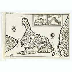
Batavia, L'an 1629.
Uncommon of Batavia (Jakarta) in 1629.From a travel book describing the early Dutch voyages by René Augustin Constantin de Renneville Recueil des voiages qui ont servi ...
Date: Amsterdam, E. Rogers, 1702
Selling price: ????
Please login to see price!
Sold in 2013
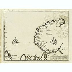
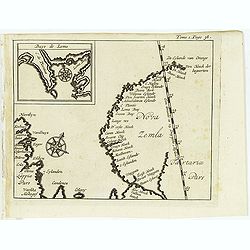
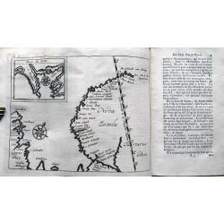
Nova Zemla.
Uncommon map of Novaya Zemlya with un unknown east coast. Based on info from Barentz. arctic voyage.From the French reissue of the account of early Dutch voyages first pu...
Date: Amsterdam, E. Roger, 1702
Selling price: ????
Please login to see price!
Sold in 2012
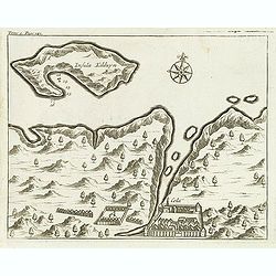
(Insula Kilduyn.)
Uncommon map of part of the coast along the Barents Sea with the island of Kildin, offshore of the river and town of Cola (Murmansk). Originally made to illustrate Willem...
Date: Amsterdam, E. Roger, 1702
Selling price: ????
Please login to see price!
Sold in 2012
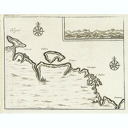
(Kegor.)
Uncommon map of part of the coast along the Barents Sea with the island of Kildin, offshore of the river and town of Cola (Murmansk). Originally made to illustrate Willem...
Date: Amsterdam, E. Roger, 1702
Selling price: ????
Please login to see price!
Sold in 2012
Cabo de Bona Esperanca / De Bay Van A de.S. Bras.
Uncommon small map of South Africa. From the French reissue of the account of early Dutch voyages first published in 1608 by Commelin. The French translation was carried ...
Date: Amsterdam, E. Roger, 1702
Selling price: ????
Please login to see price!
Sold in 2012
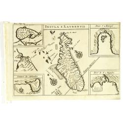
Insula S. Laurentii.
Map of Madagascar, with four inset maps. From the French reissue of the account of early Dutch voyages first published in 1608 by Commelin. The French translation was car...
Date: Amsterdam, E. Roger, 1702
Selling price: ????
Please login to see price!
Sold in 2012
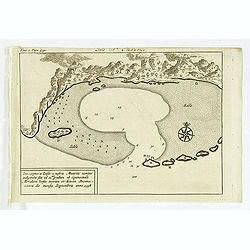
(Bird's eye view of the Bay of Bantam.)
Bird's eye view of the Bay of Bantam after Willem Lodewijcksz.From the French reissue of the account of early Dutch voyages first published in 1608 by Commelin. The Frenc...
Date: Amsterdam, E. Roger, 1702
Selling price: ????
Please login to see price!
Sold in 2014
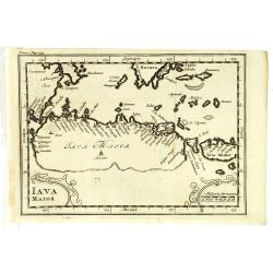
Iava Maior.
Nice early map of Java. From the French reissue of the account of early Dutch voyages first published in 1608 by Commelin. The French translation was carried out by René...
Date: Amsterdam, E. Roger, 1702
Selling price: ????
Please login to see price!
Sold in 2013
( Detroit de Baly / Detroit de Ballabuan. )
Nice early map of Bali. From the French reissue of the account of early Dutch voyages first published in 1608 by Commelin. The French translation was carried out by René...
Date: Amsterdam, E. Roger, 1702
Selling price: ????
Please login to see price!
Sold in 2013
St Helene.
Uncommon small map of St. Helena, with two coastal profile inset maps.From the French reissue of the account of early Dutch voyages first published in 1608 by Commelin. T...
Date: Amsterdam, E. Roger, 1702
Selling price: ????
Please login to see price!
Sold in 2012
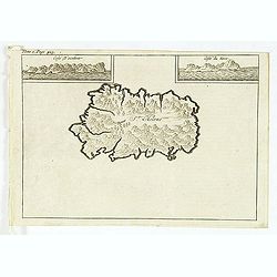
Isle St. Maurice. Ins. cygnae a Lusit, a nostris Maurity nomine indigitata, sita ad 21um gradum ab Equinoctiali Meridiem versus inventa et detecta Decima-jctava die mensis septembris anno 1598.
A bay at ST. Mauritius, a small island located in the South-West Indian Ocean, off the east coast of Madagascar. Mauritius is well known for the Dodo, the extinct bird. T...
Date: Amsterdam, E. Roger, 1702
Selling price: ????
Please login to see price!
Sold in 2021
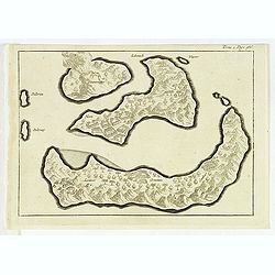
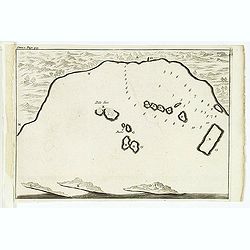
(Gunanappi / Wayer / Nera / Pulorin / Puloway .)
Uncommon map of islands in the Banda Sea. Several islands and villages are named, Wayer, Nera, Pulorin, Puloway, Lontoor, Ortattan and Combeer.From the French reissue of ...
Date: Amsterdam, E. Roger, 1702
Selling price: ????
Please login to see price!
Sold in 2012
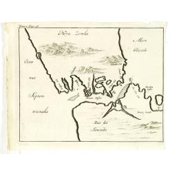
(Map of Nova Zembla with inset of Baye de Loms.)
Map of Nova Zembla with inset of Baye de Loms (5x7mm.).From the French reissue of the account of early Dutch voyages first published in 1608 by Commelin. The French trans...
Date: Amsterdam, E. Roger, 1702
Selling price: ????
Please login to see price!
Sold in 2012
Delineatio Spitsbergiae.
Map of Sipitsbergen.From the French reissue of the account of early Dutch voyages first published in 1608 by Commelin. The French translation was carried out by René Aug...
Date: Amsterdam, E. Roger, 1702
Selling price: ????
Please login to see price!
Sold in 2012
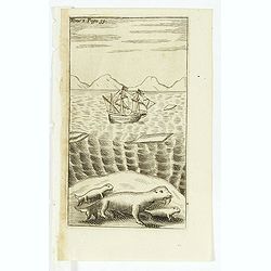
(Dutch ship in Arctic waters with 3 sea lions in the foreground)
From the French reissue of the account of early Dutch voyages first published in 1608 by Commelin. The French translation was carried out by René Augustin Constantin de ...
Date: Amsterdam, E. Rogers, 1702
Selling price: ????
Please login to see price!
Sold in 2012
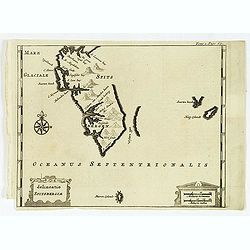
(Nova Zemla / Ocea nus Septen trionalis. )
Uncommon map of the Strait Nassau, between Nova Zembla and the Russian mainland. Originally made to illustrate Willem Barentz. arctic voyage. From the French reissue of t...
Date: Amsterdam, E. Roger, 1702
Selling price: ????
Please login to see price!
Sold in 2012
![[map of South East Asia ]](/uploads/cache/31872-250x250.jpg)
[map of South East Asia ]
The map is an expanded version of De Bry's "Mar di India", with the inclusion of an inset map of Buton (Botton I. 140x105mm.). The Straits of Buton, highlighted...
Date: Amsterdam, E. Rogers, 1702
Selling price: ????
Please login to see price!
Sold in 2012
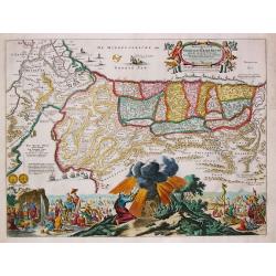
Provinciae Borealis Americae non ita Pridem Detectae aut Magis ab Europaeis Excultae.
This captivating map of North America features a huge island of California, an oversized depiction of the Great Lakes, and a misplaced Mississippi River delta. The interi...
Date: Munich, 1702
Selling price: ????
Please login to see price!
Sold in 2012
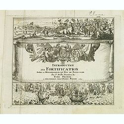
(Title page) Introduction a la Fortification. . .Tome premier
Very decorative title page of this Amsterdam edition of De Fer's important atlas "'Les forces de l'Europe, ou description des principales villes. . .", original...
Date: Amsterdam, 1693-1702
Selling price: ????
Please login to see price!
Sold in 2012
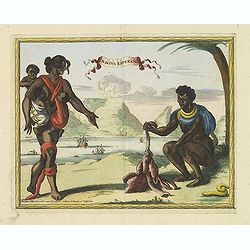
C.D.Bona Esperance.
A rare view of a South African couple. In background Table Mountain.Engraved by A.Meijer for Carolus Allard's for his Orbis habitabilis oppida et vestitus. This rare work...
Date: Amsterdam, inbetween 1683-1702
Selling price: ????
Please login to see price!
Sold in 2012
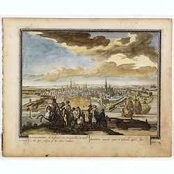
![Bandel, de Reede van de vermaerde Koopstadt Arrakan. [Chittagong]](/uploads/cache/32894-250x250.jpg)
Bandel, de Reede van de vermaerde Koopstadt Arrakan. [Chittagong]
View of Chittagong. From Schenk's Hecatompolis sive Totius Terrarum Oppida Nobiliora Centrum.. , a collection of 100 views, dedicated to the 14-year old Prussian crown pr...
Date: Amsterdam, 1702
Selling price: ????
Please login to see price!
Sold in 2014
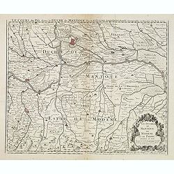
Le Cours du Po... / Les Duchez de Mantoue de Modene et de Parme. . .
Detailed and scarce map of the area of Mantua prepared by Placide de Sainte-Hélène (1648-1734). and published by Claude-Auguste Berey (1651-1732).This is the edition wh...
Date: Paris, 1702
Selling price: ????
Please login to see price!
Sold in 2016
L\'Amerique septentrionale. Noord America.
Map of North and Central America showing California as an island with indented coastline, and with place names R'Estiete, C.Blanco, P.de Carinde, Canal de S. Barbe, I. de...
Date: Amsterdam, 1702
Selling price: ????
Please login to see price!
Sold in 2013
Recueil des Voyages qui ont Servi a l'Etablissement et aux Progres de la Compagnie des Indes Orientales...
Very rare account of the Dutch voyages after Commelin. With title, 1 plate and 14 folding maps, including maps of Novaya Zemlya, Spitsbergen, Madagascar, St. Helena, Sout...
Date: Amsterdam, 1702
Selling price: ????
Please login to see price!
Sold in 2013
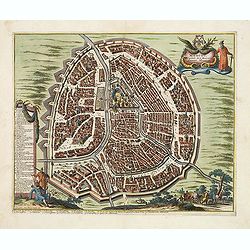
Middelburg, de Gelukkigste Koopstadt Van Geheel Zeelant.
A view of Middelburg, Netherlands, one of the three fortified towns erected to guard against the Viking raids. Petrus Schenck, (1660 – 1711) was a German engraver an...
Date: Amsterdam, 1702
Selling price: ????
Please login to see price!
Sold in 2013
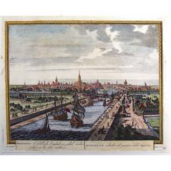
Moscou, Capitale de la Moscovie. . .
Detailed bird's-eye view of the town of Moscow with the Kremlin and old city, Kitay-gorod, at center. These are surrounded by successive rings of fortifications. The plan...
Date: Leiden, 1702
Selling price: ????
Please login to see price!
Sold
Pas-Kaart Vande Zee Kusten van Niew Nederland Anders Genaamt Niew York. . .
The first separate map of the Hudson River Valley, and the second printed of New York, Long Island and the southern New England coast. Based on original Dutch surveys ma...
Date: Amsterdam, 1682 - ca. 1702
Selling price: ????
Please login to see price!
Sold in 2013
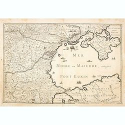
(Mer Noire ou Maieure, Pont Euxin.)
Very rare and detailed map of the Black Sea area prepared by Placide de Sainte-Hélène (1648-1734). and engraved by Claude-Auguste Berey (1651-1732).The map is of partic...
Date: Paris, 1702
Selling price: ????
Please login to see price!
Sold in 2014
Perigrinatie ofte Veertich-jarige Reyse der Kinderen Israels.
Dutch so-called ' Staten' bibles, published between 1637 and c. 1760, contained five maps: The World, ' Paradise', The Perigrinations, The Promised Land Canaan, The Trave...
Date: Amsterdam, H.,J.,P. Keur, M. Doornick en P. Rotterdam, 1702
Selling price: ????
Please login to see price!
Sold in 2020
Koppenhaven, de hooftsadt van Denemarken. .
Nice panoramic view of Copenhagen. From Schenk's "Hecatompolis sive Totius Terrarum Oppida Nobiliora Centrum...", a collection of 100 views, dedicated to the 14...
Date: Amsterdam, 1702
Selling price: ????
Please login to see price!
Sold in 2016
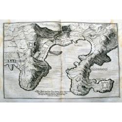
Die Stadt und der See-Haven Ville franche oder Villa franca, welche im Jahr 1691, dem Herzog von Savoyen durch die Franzosen abgenommen worden.
Detailed map of Villefranche-sur-Mer, including Saint-Jean-Cap-Ferrat, Saint-Michel, and the borders of today's Nice. It shows forts, towers, a few buildings, roads, hill...
Date: Frankfurt, 1702
Selling price: ????
Please login to see price!
Sold in 2015
![[Title page] Theatri Europaei, continu ati Vierzehender Theil. . .](/uploads/cache/37253-250x250.jpg)
[Title page] Theatri Europaei, continu ati Vierzehender Theil. . .
Two title pages
Date: Frankfurt, Johann Görlin, 1702
Selling price: ????
Please login to see price!
Sold in 2016
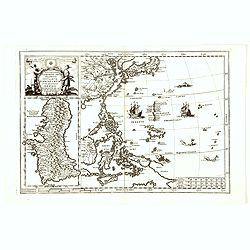
Nova Et Vera Exhibitio Gerographica Insularum Marianarum . . .
Attractive map of the Philippines, Japan, Korea and Indonesia with an inset of the island Guam, by the Jesuit Heinrich Scherer, printed in for Scherer's 'Atlas Novus'. Se...
Date: Munich, c.1702
Selling price: ????
Please login to see price!
Sold in 2016
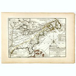
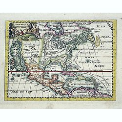
Le Canada, ou Nouvelle France la Florida, la Virginie, Pensilvanie . . .
First edition. This fine map is showing the east coast of the United States from the Caribbean up to Newfoundland, with the western border just beyond the Mississippi.The...
Date: Paris, 1702
Selling price: ????
Please login to see price!
Sold in 2016
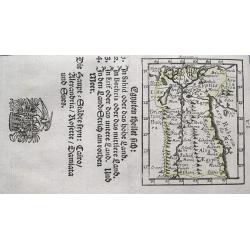
Egypten theilet sich.
Fantastic miniature map of Egypt, despite it size with many place names. Below the map it lists the areas and main cities. An increasingly rare map.
Date: Ulm, 1702
Selling price: ????
Please login to see price!
Sold in 2017
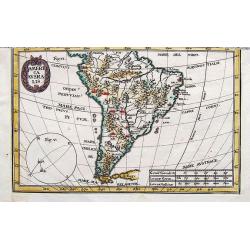
America Ausralis.
A charming and boldly engraved map of South America. This is the bottom part of a map of the Americas by Scherer. With major lakes, rivers and mountains shown, as well as...
Date: Munich, 1702
Selling price: ????
Please login to see price!
Sold in 2017
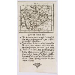
Arabia.
A lovely miniature map of the Arabian peninsular, showing the Red Sea, parts of Persia, Bagdad, parts of north eastern Africa, to the Horn of Africa. For such a small map...
Date: Ulm, 1702
Selling price: ????
Please login to see price!
Sold in 2020
Carte des Provinces Unies des Pays Bas.
Rare state of the map of the Netherlands with the imprint "a la Courone de Diamans" and " a Amsterdam chez Louis Renard Libraire près la Bourse. Decorated...
Date: Paris, 1702
Selling price: ????
Please login to see price!
Sold in 2023
Mauritius.
Uncommom map of the southern most tip of Tiera del Fuego. From "Recueil des voiages qui ont servi a l'etablissement et aux progres de la Compagnie des Indes Oriental...
Date: Amsterdam, 1702
Selling price: ????
Please login to see price!
Sold