Browse Listings
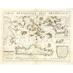
Parte meridionale dell' Arcipelago . . .
A beautiful and flamboyantly engraved large-scale map of mediterranean islands and in bottom a map of Crete. On verso a map of "Sdilles Grande olim Rhenaea Insula. ....
Date: Venice, ca. 1696
Selling price: ????
Please login to see price!
Sold
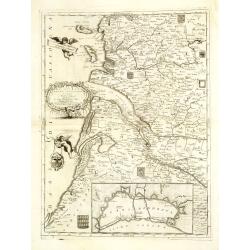
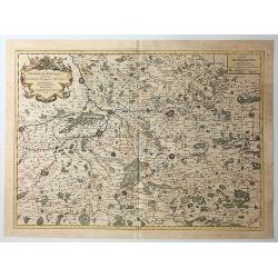
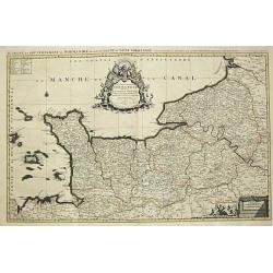
La Guienna, Medoc, Saintonge, Aunis. . .
A beautiful and flamboyantly engraved large-scale map of southwest of France with Bordeaux region with the Isles De Re and Oleron, and an inset plan of the fortified port...
Date: Venice, ca. 1696
Selling price: ????
Please login to see price!
Sold
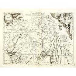
Impero del Gran Mogol. . .
A beautiful and flamboyantly engraved large-scale map of Northern India at the time of the Mogul Empire. Also including Bangaledesh, Pakistan, Nepal and the Himalayas.The...
Date: Venice, ca. 1696
Selling price: ????
Please login to see price!
Sold in 2012
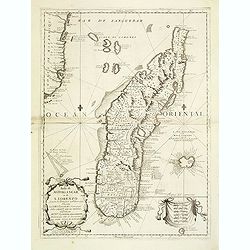
Isola di Madagascar o di S. Lorenzo Scoperta dà Portoghesi nell anno 1506. . .
A beautiful and flamboyantly engraved large-scale map of Madagascar, Bourbon and part of the coast of Mozambique. On verso a smaller map Madagascar (170x123mm) The map is...
Date: Venice, ca. 1696
Selling price: ????
Please login to see price!
Sold
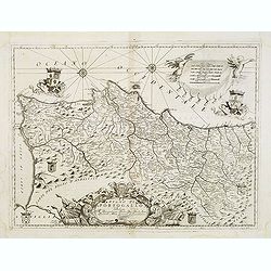
Regno di Portogallo. . .
A beautiful and flamboyantly engraved large-scale map of Portugal. On verso a map of Lisbon "S Giovanni di Lisbona" (128x162mm.)The map is the product of the la...
Date: Venice, ca. 1696
Selling price: ????
Please login to see price!
Sold in 2013
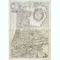
Contado d'Ollanda parte settentrionale / Contado d'ollanda parte meridionale. . .
A beautifully engraved two-sheet map of Holland locating the cities of Leiden, The Hague, Delft, Rotterdam, Breda, Utrecht, Amersfoort, s'Hertogenbosch, etc. The region i...
Date: Venice, ca. 1696
Selling price: ????
Please login to see price!
Sold in 2012

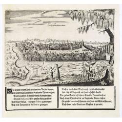
Nisen Navgorod.
An early of Nizhniy Novgorod (Gorky) on the Oka and Volga river. From the scarce Hamburg edition "Viel Vermehrte Moscowitische und Persianische Reisebeschreibung&qu...
Date: Hamburg, 1696
Selling price: ????
Please login to see price!
Sold

Kremelin Das Schloß in Muscau.
An early of the Kremlin in Moscow. From the uncommon Hamburg edition "Viel Vermehrte Moscowitische und Persianische Reisebeschreibung" by Adam Olearius.Underne...
Date: Hamburg, 1696
Selling price: ????
Please login to see price!
Sold in 2013
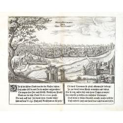
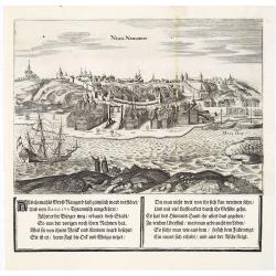
Weliki Novogord oder Gros-Navgard.
An early of tVeliki Novgorod. From the scarce Hamburg edition "Viel Vermehrte Moscowitische und Persianische Reisebeschreibung" by Adam Olearius.Underneath the...
Date: Hamburg, 1696
Selling price: ????
Please login to see price!
Sold in 2013
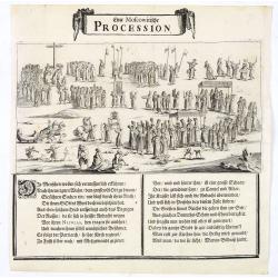
Eine Moscowitische Procession.
An view of a procession in Moscow. From the scarce Hamburg edition "Viel Vermehrte Moscowitische und Persianische Reisebeschreibung" by Adam Olearius.Underneath...
Date: Hamburg, 1696
Selling price: ????
Please login to see price!
Sold in 2023
Casan Tartarorum.
An early of Kasan in Russia. The Volga river to the lower left. Engraved by O. Koch. From the scarce Hamburg edition "Viel Vermehrte Moscowitische und Persianische ...
Date: Hamburg, 1696
Selling price: ????
Please login to see price!
Sold in 2013
Nisen Navgorod.
An early of Nizhniy Novgorod (Gorky) on the Oka and Volga river. From the scarce Hamburg edition "Viel Vermehrte Moscowitische und Persianische Reisebeschreibung&qu...
Date: Hamburg, 1696
Selling price: ????
Please login to see price!
Sold

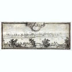
Prospectus Euripi e Palatio Rosersberg.
Two striking copper engravings featuring the Rosersberg Palace. Engraved by Swiddle in 1696.Count Erik Dahlberg (1625-1703) was a Swedish soldier, engineer and graphic a...
Date: Stockholm, 1696
Selling price: ????
Please login to see price!
Sold in 2017
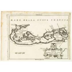
Le Bermude, Dedicate All'Illusstrissimo Sig:r Abbate Isidoro Bernardi.
Fine map of Bermuda with the title cartouche incorporating a the cardinal’s arms beneath, this map occurred in an atlas called ‘Corso Geographico Universale’.The re...
Date: Venice, 1696
Selling price: ????
Please login to see price!
Sold in 2014
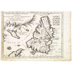
Isola Di Terra Nuova Scoperta da Gio: Cabota Veneto con suo Figliuso Sebastiano l'an 1596 24 Giugno a hore 12 . . .
A fine map of Newfoundland reduced from Coronelli's larger map of the Maritimes.The title is referencing to the discovery of the island by the Venetian explorer Giovanni ...
Date: Venice, 1696
Selling price: ????
Please login to see price!
Sold in 2014
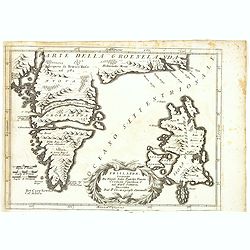
Frislanda, Scoperta da Nicolo Zeno Patritio Veneto Creduta Favolosa, o nel Mare Somersa . . .
A fine map of the mythical island of "Frislandia", based upon the writings of Nicolo Zeno.Frislanda, which was purportedly discovered by the Zeno brothers in a ...
Date: Venice, 1696
Selling price: ????
Please login to see price!
Sold in 2013
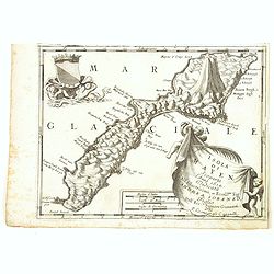
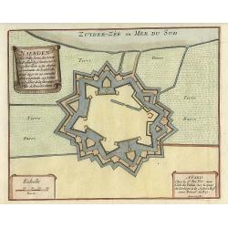
Isola Di Mayen Scoperta l'Anno 1614 . . .
A fine map of Jan Mayen Island, which was discovered in 1614 by a Dutch whaling captain, northeast of Iceland.A large volcano is shown. The map has many Dutch names.The r...
Date: Venice, 1696
Selling price: ????
Please login to see price!
Sold in 2020
![Orientalische Reise-Beschreibung. . . [with section on Taiwan]](/uploads/cache/33999-250x250.jpg)
Orientalische Reise-Beschreibung. . . [with section on Taiwan]
Fascinating travelogues by Joergen Andersen and Volquard Iversen, edited by Adam Olearius. The accuracy of the travel accounts is difficult to confirm, however, as both a...
Date: Hamburg, 1696
Selling price: ????
Please login to see price!
Sold
![Contado d'Ollanda parte settentrionale / Contado d'ollanda parte meridionale. . . [two sheet map]](/uploads/cache/34725-250x250.jpg)
Contado d'Ollanda parte settentrionale / Contado d'ollanda parte meridionale. . . [two sheet map]
A beautifully engraved two-sheet map of Holland locating the cities of Leiden, The Hague, Delft, Rotterdam, Breda, Utrecht, Amersfoort, s'Hertogenbosch, etc. The region i...
Date: Venice, ca. 1696
Selling price: ????
Please login to see price!
Sold in 2020

Vinc: Coronelli Min: Con Cosmografo Della Serenis Repub: Di Venetia.
Scarce portrait of Vincenzo Maria Coronelli, engraved for his "Corso Geographico". The remarkable Vincenzo Coronelli (1650-1718), encyclopaedist, geographer, in...
Date: Venice, 1696
Selling price: ????
Please login to see price!
Sold in 2020
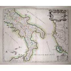
Le Royaume De Naples Divisé En Douze Provinces.
Striking large and highly detailed map of southern Italy, from Rome until Sicily. Including parts of Albania and Greece with Corfu. Also including many small islands: Tre...
Date: Paris, 1696
Selling price: ????
Please login to see price!
Sold in 2014
![Onderwysing van't Gebruyk des Hemels Pleyn Waar op de starren des hemels na 't oogh in 't plat gestelt zyn[.] Tot nut en vermaak van alle liefhebbers der wiskonsten.](/uploads/cache/34517-250x250.jpg)
Onderwysing van't Gebruyk des Hemels Pleyn Waar op de starren des hemels na 't oogh in 't plat gestelt zyn[.] Tot nut en vermaak van alle liefhebbers der wiskonsten.
Large engraved celestial chart with a rotating printed paper ring (volvelle or rete) on an off-centre axis to indicate the part of the sky visible at any date and time an...
Date: Amsterdam, Johannis van Keulen, c.1680-1696
Selling price: ????
Please login to see price!
Sold
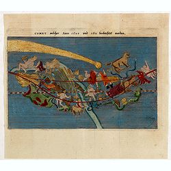
Comet Melcher Anno 1680 and 1681 beobachtet worden.
Handsomely engraved chart of the 'Great Comet of 1680' showing it's movements though the heavens. Details its relative location for approximately 50 days as it moved thro...
Date: Würtzburg, 1696
Selling price: ????
Please login to see price!
Sold in 2015
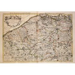
Le Comte de la Marck, les Seigneuries des Abbayes de Werden, d'Essen et la Ville Imperiale de Dortmundt
A detailed map of the Ruhrgebiet region in western Germany between Duisburg, Hamm and Olpe. With a decorative cartouche incorporating scale of miles. Published by Chez Hu...
Date: Paris, 1696
Selling price: ????
Please login to see price!
Sold in 2016
Simie, Piscopia, Nisari.
Three maps of Symi, Telos and probably Nisiros in the south Aegean Sea. Large sheet with the three maps and lengthy Italian text about the islands. From Coronelli's famou...
Date: Venice, 1696
Selling price: ????
Please login to see price!
Sold in 2015
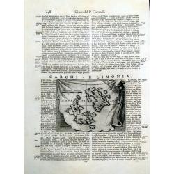
Carchi e Limonia.
Early map of the islands of Halki and Alimia near Rhodes. The map is set on a sheet with italian text, printed on both sides.
Date: Venice, 1696
Selling price: ????
Please login to see price!
Sold in 2015
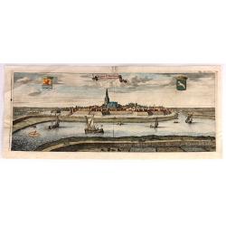
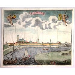
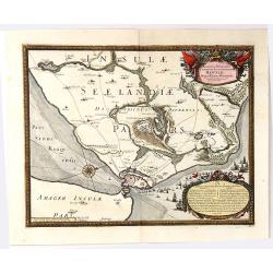
De Stad St. Maertens Dyke.
Decorative panoramic view of the town of St. Maartendijk, from "M. Smallegange Cronyk van Zeeland". The city view features a banner title cartouche with two her...
Date: Middelburg, Amsterdam, 1696
Selling price: ????
Please login to see price!
Sold in 2017
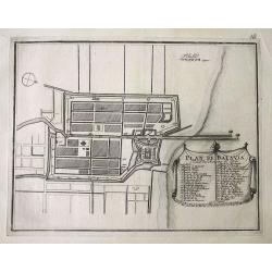
Plan de Batavia.
Plan of Jakarta, the former Dutch colonial capital in Indonesia. The title and key cartouche identifies 41 locations.
Date: Paris, 1696
Selling price: ????
Please login to see price!
Sold in 2016
De Stad Tholen
A fine plan of the Dutch town of Tholen in the province of Zeeland. It features two putti holding coats of arms. There are several ships in the foreground. Engraved by Ma...
Date: Amsterdam, 1696
Selling price: ????
Please login to see price!
Sold in 2018
Brema Cum Situatione Circumiacente
Two engravings of Bremen on one print. The upper engraving shows a birds-eye view of the fortifications of Bremen, Germany with fortifications. An index in the top right ...
Date: Nuremberg, 1696
Selling price: ????
Please login to see price!
Sold in 2016
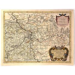
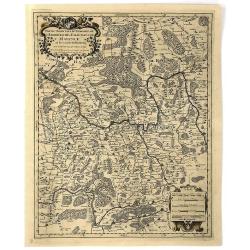
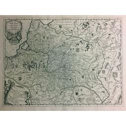
Partie Orientale du Temporel de l'Archevesché et Eslectorat de Treves
A fine detailed map of central-west Germany, including the lower Rhine region, and the junction with the Moselle River. >br />Decorated with large ornamental title ...
Date: Paris, 1696
Selling price: ????
Please login to see price!
Sold in 2023
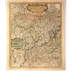
Partie Orientale du Temporel de l'Archevesché et Eslectorat de Mayence et le Comte de Remeck.
An attractive map of the eastern part of the Electorate of Mainz (Mayence) and the counties of Wertheim, Reinecke and Wuerzburch. Embellished with a large title and scale...
Date: Paris, 1696
Selling price: ????
Please login to see price!
Sold in 2019
Partie Occidentale du Temporel de l'Archevesché et Eslectorat de Treves
A fine map centred on Trier and the river Meuse, with its wine region. A figurative title cartouche in upper part and scale cartouche. By N. Sanson in 1692 from “ Les A...
Date: Paris, 1696
Selling price: ????
Please login to see price!
Sold in 2016
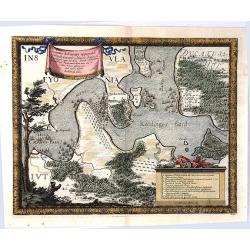
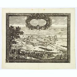
Accurata Delineatio Castrorum Suecicorum ut et Haffniae
A bird’s-eye view of an important battle for the defending of Copenhagen, Denmark. With very attractive decorative cartouches, a compass rose, and a border and featurin...
Date: Nuremburg, 1696
Selling price: ????
Please login to see price!
Sold in 2016
Accurata Delineatio Oppugnatae a Federatis, Caesareis, Polonicis, Danicis...
This beautiful bird’s-eye map shows part of the Danish island of Fyn and Jutland with Swedish, Polish and Danish forces in the Baltic. A lettered key identifies 12 loca...
Date: Nuremburg, 1696
Selling price: ????
Please login to see price!
Sold in 2016
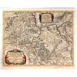
Occidentale du Palatinat et Eslectorat du Rhein Le Duché de Simmeren . . ..
A detailed map of the eastern Rheinpfalz, the immediate area around Heidelberg and Mannheim, reaching to Kaiserslautern, Gernsheim, Heilbronn and Karlsruhe. With a decora...
Date: Paris, 1696
Selling price: ????
Please login to see price!
Sold in 2016
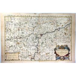
Comte de Namur Dresse sur les Memoires les Plus Nouveaux Presente a sa Majeste.
A fine, large, and detailed map of the area around the city of Namur in the province of Wallonia, in southern Belgium.From Jaillot’s “Nouvelle Introduction a le Geogr...
Date: Paris, 1696
Selling price: ????
Please login to see price!
Sold in 2017
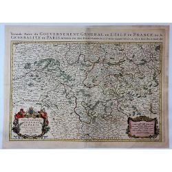
Gouvernement Generalite de Paris Divisee en Eslections.
A fine and detailed map of the region southeast of Paris between Orleans, Troyes and Nevers. From Jaillot’s “Nouvelle Introduction a le Geographie....” Embellished ...
Date: Paris, 1696
Selling price: ????
Please login to see price!
Sold in 2017
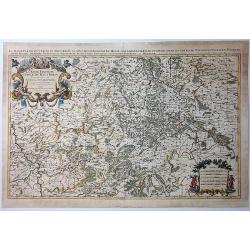
La Basse Partie du Cercle du Haute Rhein Divisee en Tous Ses Stats et Souveraintes.
A fine detailed map of the Upper Rhein region of Germany, it shows the Rhine from Cologne to Koblenz. Printed from two joined plates by Jaillot after Sanson. Title from c...
Date: Paris, 1696
Selling price: ????
Please login to see price!
Sold in 2021
Le Comte de Haynaut Divise en Chattellenies Ballages Prevoste's & c.
A fine detailed map of the Haymaut region of Belgium. It spans the area between Chatellenie to Brabant. Printed from two joined plates, by Jaillot after Sanson. Alexis-Hu...
Date: Paris, 1696
Selling price: ????
Please login to see price!
Sold in 2018
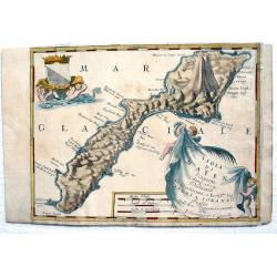
Kefalonia.
Three maps/views of Kefalonia, the largest of the Ionian islands. Includes a view of a hillside town labeled 'Cefalonia', map of the harbor of 'Argostoli', and a plan of ...
Date: Venice, 1696
Selling price: ????
Please login to see price!
Sold in 2017
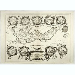
Isola di Corfu.
One of the most attractive maps of the island of Corfu ever produced. The central map is surrounded by nine plans and views of fortified locations and the ancient city of...
Date: Venice, 1696
Selling price: ????
Please login to see price!
Sold in 2019
Isola Di Mayen Scoperta l'Anno 1614...
A fine,rare map of Jan Mayen Island, which was discovered in 1614 by a Dutch whaling captain, northeast of Iceland. With two large, very decorative cartouches. A large vo...
Date: Venice, 1696
Selling price: ????
Please login to see price!
Sold in 2017
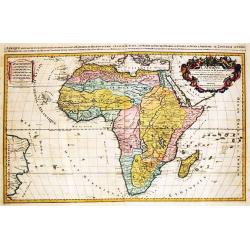
L' Afrique / divisee suivant l' estendue de ses principales parties.
An attractive large-format map of the African continent, embellished with a large title-cartouche.Alexis-Hubert Jaillot (1632-1712), French cartographer. He joined the Sa...
Date: Amsterdam, 1696
Selling price: ????
Please login to see price!
Sold in 2019
![[Isola e Regno di Candia. . .only right hand side of this two sheet map]](/uploads/cache/40771-250x250.jpg)
[Isola e Regno di Candia. . .only right hand side of this two sheet map]
The right hand side of this very attractive detailed two sheet map of Crete within wide garland of vines incorporating the names of 100 Cretan towns, coat-of-arms of Card...
Date: Venice, 1696
Selling price: ????
Please login to see price!
Sold in 2017
Lituania dedicata all. Illustrissimo signore Gio. Pietro Caualli secretario della serenissima Republica di. . .
A rare and very attractive detailed map of Lithuania and parts of Poland and the Baltic that includes numerous coats of arms in the body of the map, and two large decorat...
Date: Venice, 1696
Selling price: ????
Please login to see price!
Sold in 2018
Delineatio Regiae urbis Rigae. . .
A large, detailed, and spectacular plan of Riga during the Siege of 1656. It is is filled with battles, armies, and a large number of cavalry soldiers in the foreground. ...
Date: Nuremberg, 1696
Selling price: ????
Please login to see price!
Sold in 2020
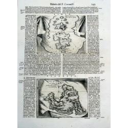
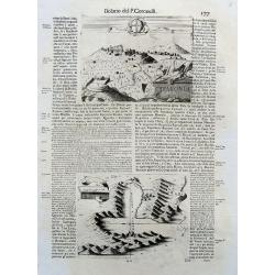
![[Text page a with view of Fort Zeelandia on Taiwan]](/uploads/cache/42043-250x250.jpg)
[Text page a with view of Fort Zeelandia on Taiwan]
Showing a sea battle offshore Fort Zeelandia on Taiwan in September 1661. The Siege of Fort Zeelandia of 1661-1662 ended the Dutch East India Company's rule over Taiwan a...
Date: Hamburg, 1696
Selling price: ????
Please login to see price!
Sold in 2018
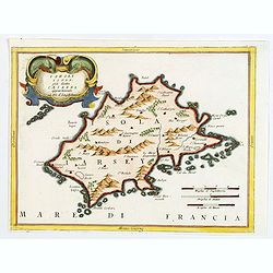
Iarsey Isola, gia detta Caesarea appartenente al Re d'Ingliterra.
An attractive small map of Jersey in the Channel Islands, with decorative cartouche from the Atlante Veneto: Isolario descrittione geografico-historia, published in Venic...
Date: Venice, 1696
Selling price: ????
Please login to see price!
Sold in 2020
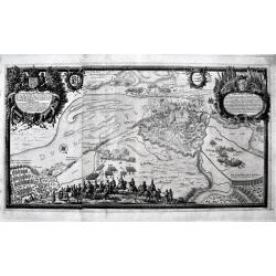
Urbs Warsavia Sedes Regum Poloniae ordinaria eo statu repraesentata quo a S.R.M. Sueciae d. 30 Aug. An.° 1655 occupabatur.
Panorama of the city of Warsaw, Poland by Erik Dahlberg who was an eye witness to the battles of Sweden against Poland and Denmark. He was the Quarter Master General of t...
Date: Nuremberg, 1696
Selling price: ????
Please login to see price!
Sold in 2019
Thorunium Primaria Prussiae Regal Urbis. . .
A decorative battle plan, showing the army of King Charles X Gustav of Sweden. Having routed the Polish armies where ever he met, them Charles X Gustav finally turned his...
Date: Nuremberg, 1696
Selling price: ????
Please login to see price!
Sold in 2019
![[Title page] Atlas Nouveau contenant toutes les parties du monde . . .](/uploads/cache/43493-250x250.jpg)
[Title page] Atlas Nouveau contenant toutes les parties du monde . . .
Fine title page of classical architectural design incorporating portraits of royalty and battle scenes.
Date: Paris, 1696
Selling price: ????
Please login to see price!
Sold in 2021
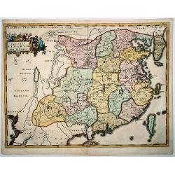
Imperii SINARUM Nova Descriptio
A reduced and much rarer version of Blaeu's map of 1655. Even the cartouche is faithfully copied from the Blaeu map. Adam Olearius was a German scholar and geographer who...
Date: Hamburg, 1696
Selling price: ????
Please login to see price!
Sold in 2020

Isole dell'Indie. . .
A beautiful and flamboyantly engraved large-scale map of the East Indies, including the Malay Peninsula, Cambodia, the Philippines and all of Indonesia and the Spice Isla...
Date: Venice, 1696
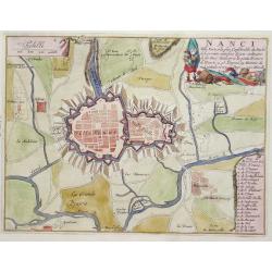
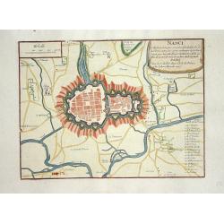
Nanci.
Nice city plan of Nancy with all rivers and canals around the city.
Date: Paris 1696
Selling price: ????
Please login to see price!
Sold
Calais.
Nice city plan of Calais with all rivers and canals around the city.
Date: Paris 1696
Selling price: ????
Please login to see price!
Sold
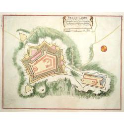
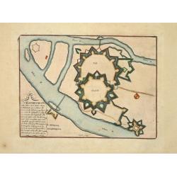
Belle-Garde.
Nice plan of Belle-Garde.
Date: Paris 1696
Selling price: ????
Please login to see price!
Sold
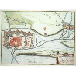
Roses.
Nice city plan of Roses in Spain.
Date: Paris 1696
Selling price: ????
Please login to see price!
Sold
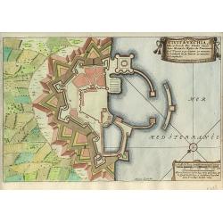
Civita-Vechia.
Nice city plan of Huningue at the Rhine river.
Date: Paris 1696
Selling price: ????
Please login to see price!
Sold
Naerden.
Nice plan of Naarden.
Date: Paris 1696
Selling price: ????
Please login to see price!
Sold
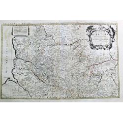
Le Comte d' Artois. Paris, 1693.
Alexis-Hubert Jaillot (1632-1712), French cartographer. He joined the Sanson heirs and redrew Nicolas Sanson's maps on a larger scale. "Atlas Nouveau" (1674), s...
Date: Amsterdam, 1696
Selling price: ????
Please login to see price!
Sold
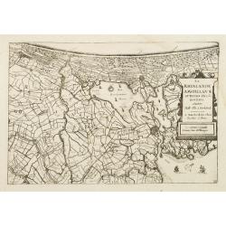
La Rhinlande Amstellande et Terres Circovosines..
Attractive map of the province of Holland, from the atlas "de Vyerighe Colom".
Date: Amsterdam, 1696
Selling price: ????
Please login to see price!
Sold
Le Cours de la Riviere du Rhein / depuis sa Source a son Embouchure./ A Paris, 1692.
Alexis-Hubert Jaillot (1632-1712), French cartographer. He joined the Sanson heirs and redrew Nicolas Sanson's maps on a larger scale. 'Atlas Nouveau' (1674), sea-atlas '...
Date: Amsterdam, 1696
Selling price: ????
Please login to see price!
Sold
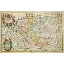
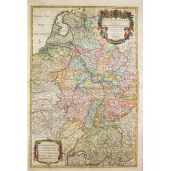
L\' Empire d\' Allemagne / distingue suivant l\' etendue de tous / les Estats, Principautes et Souverainetes. A Paris, 1696.
Alexis-Hubert Jaillot (1632-1712), French cartographer. He joined the Sanson heirs and redrew Nicolas Sanson's maps on a larger scale. 'Atlas Nouveau' (1674), sea-atlas '...
Date: Amsterdam, 1696
Selling price: ????
Please login to see price!
Sold in 2010
Le Duche et Gouvernement de Normandie divisee en Haute et Basse Normandie. Paris, 1695.
Alexis-Hubert Jaillot (1632-1712), French cartographer. He joined the Sanson heirs and redrew Nicolas Sanson's maps on a larger scale. 'Atlas Nouveau' (1674), sea-atlas '...
Date: Amsterdam, 1696
Selling price: ????
Please login to see price!
Sold
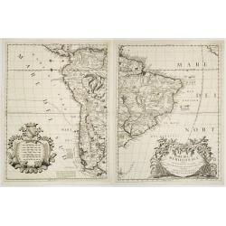
America meridionale Auttore Il P.M. Coronelli M.C. Cosmografo della Serenissima Repub. Di Venetia..
Matching set of 2 attractive large folio maps depicting all of South America in the grand Coronelli style. Splendid large ornate cartouche with Coronelli's normal flouris...
Date: Venice 1696
Selling price: ????
Please login to see price!
Sold
Le Comte de Flandre / divise en ses / Chastellenies et Balliages &c / le Franc de Bruges et le Pays de Waes. A Paris, 1696.
Alexis-Hubert Jaillot (1632-1712), French cartographer. He joined the Sanson heirs and redrew Nicolas Sanson's maps on a larger scale. 'Atlas Nouveau' (1674), sea-atlas '...
Date: Amsterdam, 1696
Selling price: ????
Please login to see price!
Sold in 2010
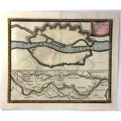
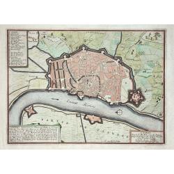
Brest
Nice city plan of Brest with the fortificationwalls and the chateau.
Date: Paris 1696
Selling price: ????
Please login to see price!
Sold
Manheim
Small city plan of Manheim with the fortification walls at the Rhine river.
Date: Paris 1696
Selling price: ????
Please login to see price!
Sold
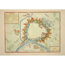
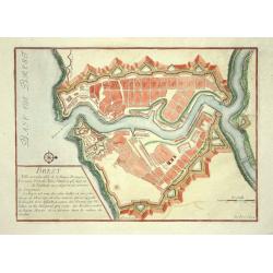
Vienne
Nice city plan of Vienna with the fortificationwalls.
Date: Paris 1696
Selling price: ????
Please login to see price!
Sold
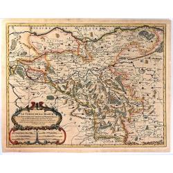
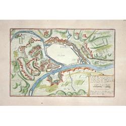
Corso del Reno, Parte Meridionale.
Vicenzo Maria Coronelli (1650-1718), Franciscan Friar and cosmographer of Venice. Made many globes. Most famous work is his atlas 'Atlante Veneto' (1690-96).A map of Swit...
Date: Venice, 1696
Selling price: ????
Please login to see price!
Sold
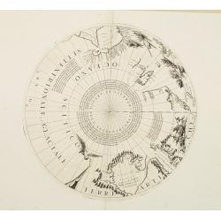
2 Polar calottes from a globe.
Set of two polar calottes from 110 centimetres in diameter globe of 1688 including northern part of Baffin Bay, Greenland, Nova Zembla. Coronelli elected to follow the Du...
Date: Venice 1696
Selling price: ????
Please login to see price!
Sold
Nanci.
Nice city plan of Nancy with all rivers and canals around the city.
Date: Paris 1696
Selling price: ????
Please login to see price!
Sold
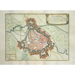
Valenciennes
Nice city plan of Valenciennes.
Date: Paris 1696
Selling price: ????
Please login to see price!
Sold
Anvers
Nice city plan of Antwerp.
Date: Paris 1696
Selling price: ????
Please login to see price!
Sold
Namur
Nice city plan of Namen.
Date: Paris 1696
Selling price: ????
Please login to see price!
Sold
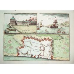
Lisbonne
A very decorative, beautifully engraved plan of Lisbon. The work identifies the boundaries of the ancient section of Lisbon within its greater contemporary (i.e., 17th c...
Date: Paris, ca. 1696
Selling price: ????
Please login to see price!
Sold
Anvers
Nice city plan of Antwerp.
Date: Paris 1696
Selling price: ????
Please login to see price!
Sold
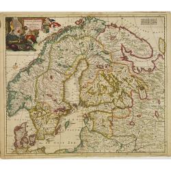
Accuratissima..Sueciae, Daniae et Norvegiae, Tabula.
Signed lower right with privilege. A delicately colored map of Scandinavia with a large title cartouche.
Date: Amsterdam 1696
Selling price: ????
Please login to see price!
Sold
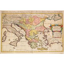
Estats / de l' Empire de Turcs / en Europe.
Alexis-Hubert Jaillot (1632-1712), French cartographer. He joined the Sanson heirs and redrew Nicolas Sanson's maps on a larger scale. 'Atlas Nouveau' (1674), sea-atlas '...
Date: Amsterdam, 1696
Selling price: ????
Please login to see price!
Sold