Browse Listings
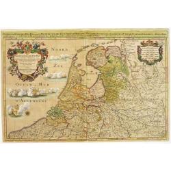
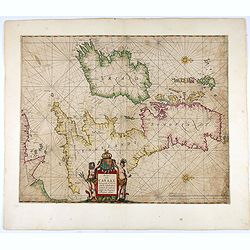
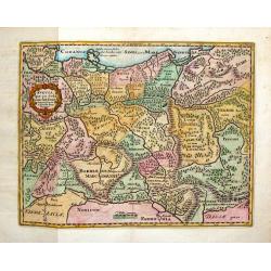
Provinces-Unies des Pays-Bas..
A large and most beautifully colored title cartouche with fighting ships on the sea: a very decorative map, prepared by N.Sanson.Because of its dimensions the map was eng...
Date: Paris, 1696
Selling price: ????
Please login to see price!
Sold in 2008
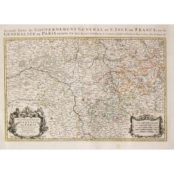
Seconde Partie du Gouvernement General de l\' Isle de France, ou la Generalite de Paris. Paris, 1692.
Alexis-Hubert Jaillot (1632-1712), French cartographer. He joined the Sanson heirs and redrew Nicolas Sanson's maps on a larger scale. 'Atlas Nouveau' (1674), sea-atlas '...
Date: Amsterdam, 1696
Selling price: ????
Please login to see price!
Sold in 2013
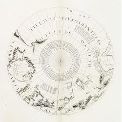
Polar calottes from a globe.
Rare polar calottes from a 110 centimetres in diameter globe of 1688 including northern part of Baffin Bay, Greenland, Nova Zembla. Coronelli elected to follow the Dutch ...
Date: Venice 1696
Selling price: ????
Please login to see price!
Sold
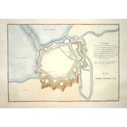
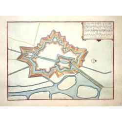
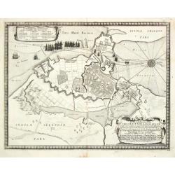
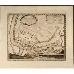
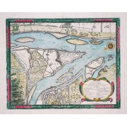
Conde
Small city plan of Conde with the fortification walls.
Date: Paris 1696
Selling price: ????
Please login to see price!
Sold
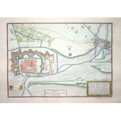
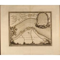
Sas de Gand
Small city plan of Sas van Gent with the fortification walls.
Date: Paris 1696
Selling price: ????
Please login to see price!
Sold
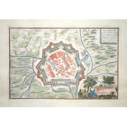
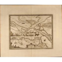
Maubeuge
Small city plan of Maubeuge with the fortification walls.
Date: Paris 1696
Selling price: ????
Please login to see price!
Sold
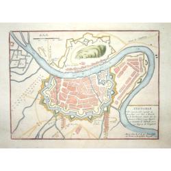
Grenoble.
Nice city plan of Grenoble.
Date: Paris 1696
Selling price: ????
Please login to see price!
Sold
Calais.
Nice city plan of Calais.
Date: Paris 1696
Selling price: ????
Please login to see price!
Sold
Thionville.
Nice city plan of Thionville.
Date: Paris 1696
Selling price: ????
Please login to see price!
Sold
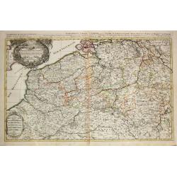
Les provinces des Pays-Bas Catholique. A Paris, 1696.
Alexis-Hubert Jaillot (1632-1712), French cartographer. He joined the Sanson heirs and redrew Nicolas Sanson's maps on a larger scale. 'Atlas Nouveau' (1674), sea-atlas '...
Date: Amsterdam, 1696
Selling price: ????
Please login to see price!
Sold in 2020
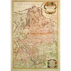
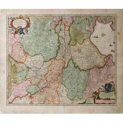
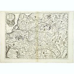
Le Cercle de Westphalie / divise en tous ses / estats et souverainetes. A Paris, 1692.
Alexis-Hubert Jaillot (1632-1712), French cartographer. He joined the Sanson heirs and redrew Nicolas Sanson's maps on a larger scale. 'Atlas Nouveau' (1674), sea-atlas '...
Date: Amsterdam, 1696
Selling price: ????
Please login to see price!
Sold in 2010
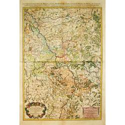
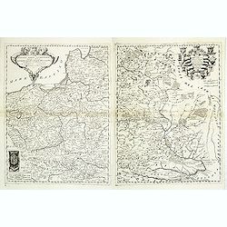
Le Cercle Eslectoral du Rhein. Paris, 1692.
Alexis-Hubert Jaillot (1632-1712), French cartographer. He joined the Sanson heirs and redrew Nicolas Sanson's maps on a larger scale. 'Atlas Nouveau' (1674), sea-atlas '...
Date: Amsterdam, 1696
Selling price: ????
Please login to see price!
Sold in 2014
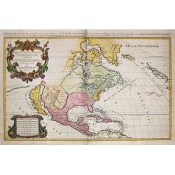
Amerique septentrionale / divisee en ses principales parties. Paris, 1695.
Alexis-Hubert Jaillot (1632-1712), French cartographer. He joined the Sanson heirs and redrew Nicolas Sanson's maps on a larger scale. 'Atlas Nouveau' (1674), sea-atlas '...
Date: Amsterdam, 1696
Selling price: ????
Please login to see price!
Sold
![[2 sheets] Parte settentrionale del regno d'inghilterra.. [with] Parte Meridionale der regno . . .](/uploads/cache/23871-250x250.jpg)
[2 sheets] Parte settentrionale del regno d'inghilterra.. [with] Parte Meridionale der regno . . .
Matching set of 2 attractive large folio maps depicting the northern and southern parts of England. Including four large cartouches and table of counties, towns, etc. Sho...
Date: Venice, 1696
Selling price: ????
Please login to see price!
Sold in 2015
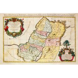
Judea seu Terra Sancta / quae / Hebraeorum sive Israelitarum / in suas duodecim tribus divisa.
Alexis-Hubert Jaillot (1632-1712), French cartographer. He joined the Sanson heirs and redrew Nicolas Sanson's maps on a larger scale. 'Atlas Nouveau' (1674), sea-atlas '...
Date: Amsterdam, 1696
Selling price: ????
Please login to see price!
Sold in 2008
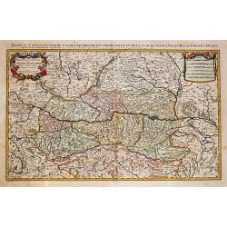
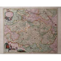
Partie du Cercle d' Austriche / scavoir / l' Archduche d' Austriche / divise en Haute et Basse. / A Paris, 1692.
Alexis-Hubert Jaillot (1632-1712), French cartographer. He joined the Sanson heirs and redrew Nicolas Sanson's maps on a larger scale. 'Atlas Nouveau' (1674), sea-atlas '...
Date: Amsterdam, 1696
Selling price: ????
Please login to see price!
Sold in 2020
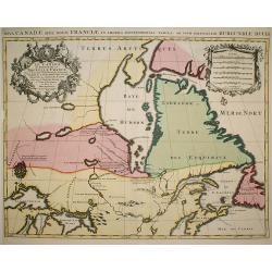
Le Canada ou Partie de la Nouvelle France..
A derivative of the 1685 map with a number of alterations including posts established by the French to prevent the Indians trading with the English in the Hudson's Bay an...
Date: Paris, 1696
Selling price: ????
Please login to see price!
Sold in 2009
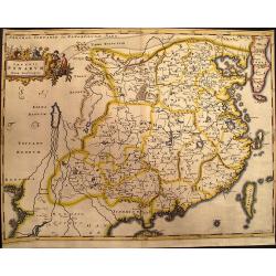
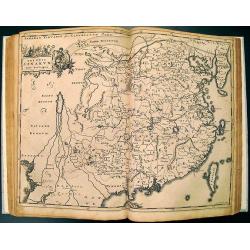
Imperii Sinarum Nova Descriptio
A reduced and much rarer version of Blaeu's map of 1655. Even the cartouche is faithfully copied from the Blaeu map. Adam Olearius was a German scholar and geographer who...
Date: Hamburg, 1696
Selling price: ????
Please login to see price!
Sold in 2009
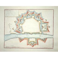
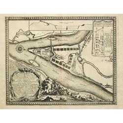
Plan de la Fortresse de Portolongone en l'Ysle Delbe...
Exceedingly rare plan of Porto Longone, also known as Porto Azzurro, on the Island of Elba. Published in Les Glorieuses Conquestes de Louis le Grand - one of the most imp...
Date: Paris, 1696
Selling price: ????
Please login to see price!
Sold in 2010
Ducatus Brabantia divise in Hispanicam et Batavam?
Carol Allard map of Dutch and Belgium Brabant and Holland with beautiful original color. Shows from cities of Breda, Holland in the north to Namen, Belgium in the south.
Date: Amsterdam, 1696
Selling price: ????
Please login to see price!
Sold in 2010
![[Globe gore of the Black Sea, with Russia, Georgia, Cyprus and Gulf of Bassora]](/uploads/cache/29159-250x250.jpg)
[Globe gore of the Black Sea, with Russia, Georgia, Cyprus and Gulf of Bassora]
Half-gore from his 110 centimetres in diameter globe of 1688 with Cyprus, part of Egypt, Saudi Arabia, Crimea, Russia including Ukraine and Moscow. Some of the half-gores...
Date: Venice, 1696
Selling price: ????
Please login to see price!
Sold in 2010
Noviffima Comitatus Zutphaniae, Totiufa Fluminis Isulae Descriptio.
A map by Nicholas Visscher from his Atlas Minor showing the regions between Emmerick, Germany and Kampen. Major rivers, lakes and cities are depicted, and the map feature...
Date: Amsterdam, 1696
Selling price: ????
Please login to see price!
Sold in 2010
Ducatus Lutzenburgi, Noviffima et Accuratiffima Delinatio
A map of Luxembourg by Nicholas Visscher from his Atlas Minor which includes the towns of Namur, Liege, Trier and Metz, as well as major rivers. A detailed cartouche feat...
Date: Amsterdam, 1696
Selling price: ????
Please login to see price!
Sold in 2010
Ducatus Geldriae et Zutphaniae Comitatus
Map of Gelderland by Nicholas Visscher from his "Atlas Minor Sive Geographica". This map depicts major cities such as Buren, Grol, and Alphen and includes dynam...
Date: Amsterdam, 1696
Selling price: ????
Please login to see price!
Sold in 2010
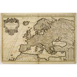
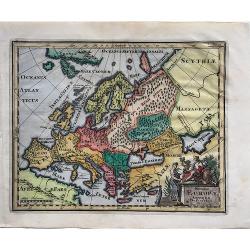
L'Europe divisee suivant l'estendue de ses principaux estats. . .
Fine map of Europe with a decorative title and scale cartouche.Alexis-Hubert Jaillot (1632-1712), was a French cartographer. He joined the Sanson heirs and redrew Nicolas...
Date: Amsterdam, 1696
Selling price: ????
Please login to see price!
Sold
Orientalische Reise-Beschreibung. . .
Fascinating travelogues by Joergen Andersen and Volquard Iversen, edited by Adam Olearius. The accuracy of the travel accounts is difficult to confirm, however, as both a...
Date: Hamburg, 1696
Selling price: ????
Please login to see price!
Sold in 2012
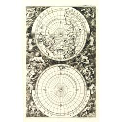
Polus Arcticus / Polus Antarcticus Tom II p.11.
A very interesting map with vertical orientation showing twin polar projections. The South Pole shows Tierra del Fuego as the only land, and the North Pole includes a por...
Date: Nuremberg, 1696
Selling price: ????
Please login to see price!
Sold in 2010
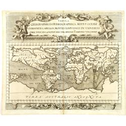
Tabula geographico-hydrographica motus Tom II p.132.
World map depicting ocean currents, volcanoes and deep-sea chasms. The continents are void of political detail and only major lakes, rivers and volcanoes are shown. There...
Date: Nuremberg, 1696
Selling price: ????
Please login to see price!
Sold in 2011
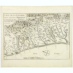
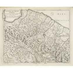
Carte de la Colchide appelée maintenant Mengrelie et pars ceux du pays Odisci.
An early map showing the extent of the fortifications of the Ottoman Empire along the east of the Black Sea and in the foothills of the Caucasus. Vignettes of buildings, ...
Date: Paris, 1664-1696
Selling price: ????
Please login to see price!
Sold in 2011
![Globe gore [ Het Niew Hollandt..] (New Holland)](/uploads/cache/31208-250x250.jpg)
Globe gore [ Het Niew Hollandt..] (New Holland)
A globe gore including the Spice Islands, Papua New Guinea and the North Coast of Australia and an explanatory of "Lochac". Italian text below the map which is ...
Date: Venice, 1696
Selling price: ????
Please login to see price!
Sold in 2011
![Globe gore [Malysia, Thailand, Western China.]](/uploads/cache/31211-250x250.jpg)
Globe gore [Malysia, Thailand, Western China.]
A globe gore of modern day Thailand, Vietnam, Cambodia, Burma, Nepal, Malaysia, Singapore, northern part of Sumatra, Indian Ocean, and western China. Published in Coronel...
Date: Venice, 1696
Selling price: ????
Please login to see price!
Sold in 2011
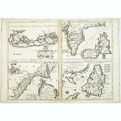
Le Bermude / Frislanda / Isola di Mayen / Isola di Terra Nuova.
Four maps printed on one large sheet, each from a separate copper plate. The remarkable Vincenzo Coronelli (1650-1718), encyclopaedist, geographer, inventor and Doctor of...
Date: Venice, 1696
Selling price: ????
Please login to see price!
Sold
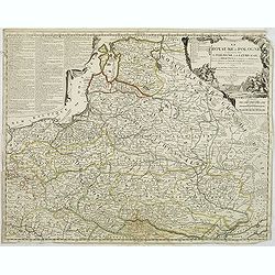
Lituania dedicata all. Illustrissimo signore Gio. Pietro Caualli secretario della serenissima Republica di ...
A scarce and very attractive detailed map of Lithuania and parts of Poland and the Baltic and includes numerous coats of arms in the body of the map and two large decorat...
Date: Venice, 1696
Selling price: ????
Please login to see price!
Sold in 2011
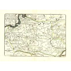
Polonia parte occidentale, Descritta, e Dedicata Dal P.Mae
A scarce and very attractive detailed map of Poland in two un-joined sheets and includes numerous coats of arms in the body of the map and a large decorative title cartou...
Date: Venice, 1696
Selling price: ????
Please login to see price!
Sold in 2011
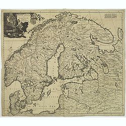
Accuratissima regnorum Sueciae, Daniae et Norvegiae, Tabula.
Uncommon map of Scandinavia with a large title cartouche in upper left corner. Signed lower right with privilege.Including Sweden, Denmark, Norway and small part of Russi...
Date: Amsterdam, 1696
Selling price: ????
Please login to see price!
Sold in 2011
Grece ou Partie Meridionale de la Turquie en Europe..
From El atlas Abbreviado.
Date: Antwerp 1697
Selling price: ????
Please login to see price!
Sold
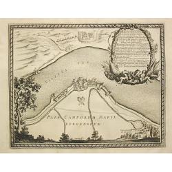
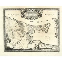
Pars Camporum Marienburgensium.
From Pufendorf's famous chronicle on the Baltic area, ' Histoire du règne de Charles Gustave, roy de Suède'. Marienburg.
Date: Nürnberg, C. Riegel, 1697
Selling price: ????
Please login to see price!
Sold in 2017
Ichnographia Castelli Pillau et adiacentium locorum Anno 1656.
From Pufendorf's famous chronicle on the Baltic area, ' Histoire du règne de Charles Gustave, roy de Suède' A decorative map of the town of Pillau (Baltiisk) on the ent...
Date: Nürnberg, C. Riegel, 1697
Selling price: ????
Please login to see price!
Sold in 2016
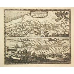
Castellum ad Butzfliet / Castellum vulgo Kruckschanz ad Oppidum Elmeshoorn.
From Pufendorf's famous chronicle on the Baltic area, ' Histoire du règne de Charles Gustave, roy de Suède'Two views on one sheet of fortifications on the river Elbe ne...
Date: Nürnberg, C. Riegel, 1697
Selling price: ????
Please login to see price!
Sold in 2008
Sylva Montow Werd.
From Pufendorf's famous chronicle on the Baltic area, ' Histoire du règne de Charles Gustave, roy de Suède'A print showing the crossing of the Vistal river by the Swede...
Date: Nürnberg, C. Riegel, 1697
Selling price: ????
Please login to see price!
Sold in 2009
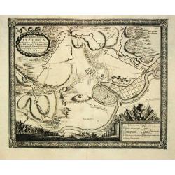
Ichnographia Oppidi Itzehoae.
From Pufendorf's famous chronicle on the Baltic area, ' Histoire du règne de Charles Gustave, roy de Suède'A plan of the town of Itzehoae on the Stoer river.
Date: Nürnberg, C. Riegel, 1697
Selling price: ????
Please login to see price!
Sold in 2008
Baltus minor / Koldinger fiord.
From Pufendorf's famous chronicle on the Baltic area, ' Histoire du règne de Charles Gustave, roy de Suède'A map of the Lille Belt near Kolding.
Date: Nürnberg, C. Riegel, 1697
Selling price: ????
Please login to see price!
Sold in 2008
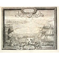
Typus Solemnitatum quibus Tabula pacis inter regna Sueciae et Daniae.
From Pufendorf's famous chronicle on the Baltic area, ' Histoire du règne de Charles Gustave, roy de Suède'
Date: Nürnberg, C. Riegel, 1697
Selling price: ????
Please login to see price!
Sold in 2008
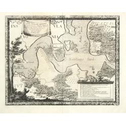
Situs locorum circa neoburgum in Fionia
From Pufendorf's famous chronicle on the Baltic area, ' Histoire du règne de Charles Gustave, roy de Suède'A map of Nyborg and vincinity on the island of Funen.
Date: Nürnberg, C. Riegel, 1697
Selling price: ????
Please login to see price!
Sold in 2010
Delineatio Geometrica Urbis Haffniae Daniae Regnum.
From Pufendorf's famous chronicle on the Baltic area, ' Histoire du règne de Charles Gustave, roy de Suède'
Date: Nürnberg, C. Riegel, 1697
Selling price: ????
Please login to see price!
Sold
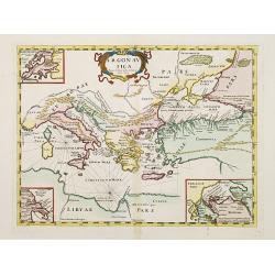
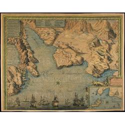
Argonautica.
A very rare map of the Mediterranean Basin, centered on Greece. Decorative title cartouche in the upper part of the map. Three inset maps in upper left-hand corner and lo...
Date: Italy 1697
Selling price: ????
Please login to see price!
Sold
Ichnographia Castelli ad Caput Vistulae vulgo Hoft Schantz.
From Pufendorf's famous chronicle on the Baltic area, ' Histoire du règne de Charles Gustave, roy de Suède'.A splendid view of the Hoft Schanz on the old and the Dantzi...
Date: Nürnberg, C. Riegel, 1697
Selling price: ????
Please login to see price!
Sold in 2017
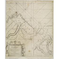
Nieuwe gelyk-gradige Paskaart van Muskovien in grootbestek. Begrypende Noorwegen, Finmarken, Lapland en Rusland. Strekkende van Hitland tot Ysland, Beren Yland. . .
Rare sea chart map of ?Muskovien?: comprising northern parts of Norway, Finland and Russia, with insets of Kola peninsula and the course of the Archangel (Dwina) rivers. ...
Date: Amsterdam, 1697
Selling price: ????
Please login to see price!
Sold in 2008
Delineatio Regionis Vbi Wistula, et Bugus confluunt , vt et Castrorum Suedicorum
Attractive copper engraved map of view of the Wistula River, Nowy Dwor, Mazowiecki, north west of Warsaw (Warszawa) in Poland. From the famous chronicle of Baron von Pufe...
Date: Nuremberg, 1697
Selling price: ????
Please login to see price!
Sold in 2009
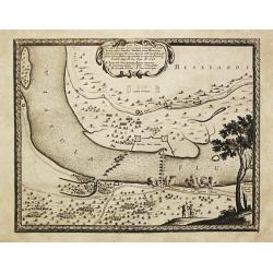
Delineatio Fortality Polonorum ad Lysouiam quo a Serenissimo Principe Palatino Adolpho Johanne Supremo Duce militiae Sueciae
Beautifully copper engraved plan of the region along the Vistula River opposite the village of Dirzovia, close to Malbork and Tczewa. From the famous chronicle of Baron v...
Date: Nuremberg, 1697
Selling price: ????
Please login to see price!
Sold in 2009

Situs loci in quo Situs loci in quo Sereniss: Princ. Sueciæ General.mus subito - Vistulam inter Montower Spitz et paruum Montow trajecit, cohortes Polon. fugavit, - - fluminiq. Pontem imposuit d. 4. Aug: Ao 1658
Nice copper engraved plan of the region along the Vistula River. From the famous chronicle of Baron von Pufendorf.
Date: Nuremberg, 1697
Selling price: ????
Please login to see price!
Sold in 2009
Delineatio et Situs Montower Spitze / Exquisita Delineatio Fluvii Nogat
Two copper engraved maps on one sheet. Top map showing the area Vitula River and Nogat River crossing at "Montower Spitze". The second map showing the course of...
Date: Nuremberg, 1697
Selling price: ????
Please login to see price!
Sold in 2009
Legatione del Ducato d'Urbino . . .
A uncommon, late 17th century map of part of the Urbino region, based on the reports of Giacomo Cantelli da Vignola and published in Rome by Domenico de Rossi's world atl...
Date: Rome, ca.1697
Selling price: ????
Please login to see price!
Sold in 2009
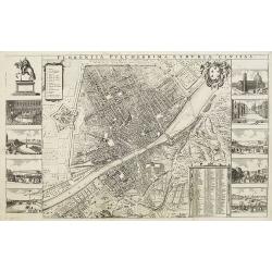
Florentia Pulcherrima et Ruriae Civitas.
Detailed bird's-eye view of the town of Florence from Frederick de Wit's rare town book. With two keys 1-17 and 1-228 to important spots in town. To the left and right on...
Date: Amsterdam, 1697
Selling price: ????
Please login to see price!
Sold in 2009
![Parte Occidentale dell' Europa,... [together with] Parte Orientale dell' Europa,...](/uploads/cache/91022-250x250.jpg)
Parte Occidentale dell' Europa,... [together with] Parte Orientale dell' Europa,...
Coronelli's double sheet map of Europe, from Atlante Veneto. Decorated with all manner of flora and fauna.
Date: Venice, 1690 - 1697
Selling price: ????
Please login to see price!
Sold in 2010
Gore sheet by Coronelli.
Gore sheet of eastern Europ and the Middle East for the big globe (110 cm in diameter) by Coronelli. Rare.
Date: Venice, 1690 - 1697
Selling price: ????
Please login to see price!
Sold in 2009
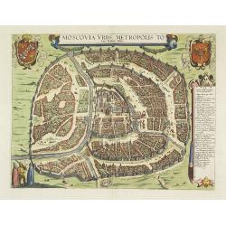
Moscovia urbs Metropolis totius Russiae Albae.
Detailed bird's-eye town-plan of Moscow from Frederick de Wit's rare townbook. With a key (1-20) to important spots in town. Frederick de Wit published after 1694 a town ...
Date: Amsterdam, 1697
Selling price: ????
Please login to see price!
Sold in 2012
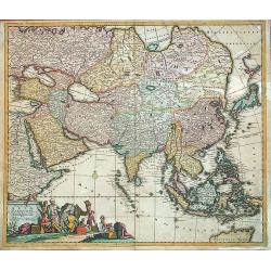
![[Asia]](/uploads/cache/91287-250x250.jpg)
[Asia]
Important Asia map of V.M. Coronelli showing SE Asia with Japan and parts of Australia and New Zealand. Many discoveries around Australia are described with dates, place ...
Date: Venice, 1697
Selling price: ????
Please login to see price!
Sold in 2009
Dantiscum / Ichnographia Urbi Gedani et Castelli ad ostium Uistulae vulgo Weichselmunde.
Beautiful copper engraved map of the Vistula delta with a town plan and panoramic view of Danzig/Gdansk by S. Pufendorf. With several sailing ships and a compass rose in ...
Date: Nuremberg, 1697
Selling price: ????
Please login to see price!
Sold in 2011
Les Estats de la Couronne de Pologne avec privilege du Roy.
Charming little map of Poland, engraved by C.Inselin and published by Nicolas de Fer.
Date: Paris, 1697
Selling price: ????
Please login to see price!
Sold in 2010
Le royaume de Pologne comprenant les états de Pologne et de Lithuanie, divisez en provinces et subdivisez en Palatinats, selon les mémoires de Starovolse, de Hartknoch. . .
Uncommon and detailed map of Poland prepared by Tillemont. Part of the Black Sea in the lower right corner.
Date: Paris, 1697
Selling price: ????
Please login to see price!
Sold in 2011
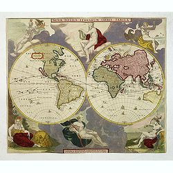
Nova Totius Terrarum Orbis Tabula.
Two hemispheres surrounded by six robust statuesque figures representing Day and Night and the four elements, each, except for mother Earth, proudly unclothed. Subsequent...
Date: Amsterdam, 1688-1697
Selling price: ????
Please login to see price!
Sold in 2011
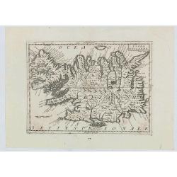
Isola d'Islanda
The map is a reduced copy of Joris Carolus', but the forms of the names and other features suggest that the model was the version by Johannes Janssonius rather than that ...
Date: Venice, 1697
Selling price: ????
Please login to see price!
Sold in 2020
Pascaart vant Canaal Begrypende in sich Engelandt, Schotlandt, en jerlandt, als mede een gedeelt van Francryck.
Map of the English channel, oriented with east at the top and including part of France and the British isles.The beautiful title cartouche with Neptune, a river goddess a...
Date: Amsterdam, 1697
Selling price: ????
Please login to see price!
Sold in 2021
Summa Europae Antiquae descriptio.
A fascinating small map of Ancient Europe from Philipp Clüver's famous "Introductionis in Universam geographicam", which was first published in Leiden in 1624....
Date: Amsterdam, 1697
Selling price: ????
Please login to see price!
Sold in 2022
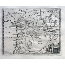
Syriae Sive Soriae Descriptio.
A nice map of ancient Syria, filled with many details of the local topography and place names, and with a decorative elephant title cartouche. Phillip Cluver, latinised a...
Date: Amsterdam, 1697
Selling price: ????
Please login to see price!
Sold in 2023
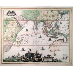
Nova Tabula India Orientalis Hugo Allard Excudit jnde Kalverstraet inde Werrelt Caert.
Extremely decorative, large, very rare of Africa, Asia and Australia by Hugo Allard. This is the even rarer first state of the map, which appeared around 1697 in Amsterda...
Date: Amsterdam, 1697
Selling price: ????
Please login to see price!
Sold in 2021
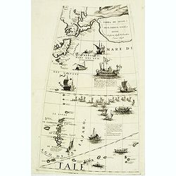
(Globe gore with part of Japan, Kamtchatka, Yedo and Ladrones)
Querter gore from his 110 centimeters in diameter globe of 1688 with part of Japan, eastern Siberia, Yedo and Ladrones. The sea is filled with a large Japanese navel batt...
Date: Venice, 1696 / 1697
Selling price: ????
Please login to see price!
Sold in 2012
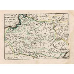
Les Estats de la Couronne de Pologne.
Charming little map of Poland, from Petit et Nouveau Atlas, engraved by C. Inselin and published by Nicolas de Fer.
Date: Paris, 1697
Selling price: ????
Please login to see price!
Sold in 2012
Exactissima Asiae delineatio in praecipuas. . .
This extremely decorative, large map of the Asian continent and East Indies is based on Frederick de Wit's map of 1675. Good details reflect the surveys of Dutch East Ind...
Date: Amsterdam, 1697
Selling price: ????
Please login to see price!
Sold in 2013
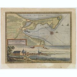
Neoburgum Fioniae oppidum. . .
Decorative plan and panoramic view of the town of Nyborg in Denmark at the coast of Baltic Sea in Fyn. Prepared by Count Erik Jönsson Dahlberg[h] (1625-1703). Military e...
Date: Stockholm, 1697
Selling price: ????
Please login to see price!
Sold in 2014

Saswestaholm & Sioosa.
A lovely copper engraving of two prominent buildings in Sweden by Dahlberg. There are two decorative coasts of arms held by putti. Count Erik Dahlberg (1625-1703) was a S...
Date: Stockholm, 1697
Selling price: ????
Please login to see price!
Sold in 2017
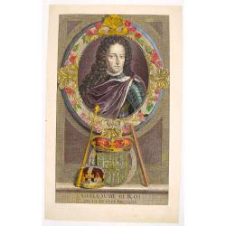
Portrait of "Guillaume III Roi".
Hand colored engraving of King William III of the Netherlands. Engraved by E. Desrochers in 1697. Prince Willen III (1650-1702) of the Netherlands became King William I ...
Date: Amsterdam, 1697
Selling price: ????
Please login to see price!
Sold in 2016
Svevia Quae Cis Coda Num Suit Sinum Antiqua Descriptio.
Fine hand colored copper engraving featuring the region that is present-day Pomerania showing the ancient germanic tribes extending to the Danube River. Adorned with a fa...
Date: Paris, 1697
Selling price: ????
Please login to see price!
Sold in 2015
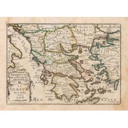
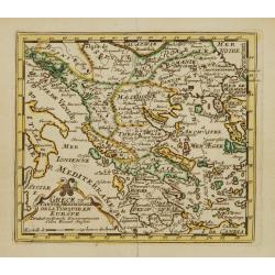
La Grece.
A map of Greece, from Petit et Nouveau Atlas, engraved by C. Inselin and published by Nicolas de Fer.It is to be noted that this particular atlas is scarcer than the othe...
Date: Paris, 1697
Selling price: ????
Please login to see price!
Sold in 2014
Geometrica Delineatio Munitionis Dantziger Hoeft.
From Pufendorf's famous chronicle on the Baltic area, ' Histoire du règne de Charles Gustave, roy de Suède'A detailed map of the fortress Dantziger Hoeft.
Date: Nürnberg, C. Riegel, 1697
Selling price: ????
Please login to see price!
Sold in 2016
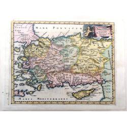
Chersonesi Quae Hodie Natolia Descripto.
Decorative map of Asia Minor extending from Armenia Minor to Hardianopolis and Crete to Cyprus. It was created by Philip Cluverius in 1697.
Date: Leiden, 1697
Selling price: ????
Please login to see price!
Sold in 2018
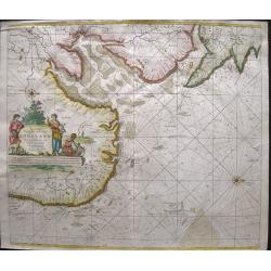
Pas-caert van de Zee-custen van ENGELAND van Orfordness tot aen Flamborger Hooft.
Beautifully colored sea chart of east coast of England, oriented to the West. Early state with engraved number 22. With nice decorations of the area and two compass rose...
Date: Amsterdam, 1697
Selling price: ????
Please login to see price!
Sold in 2016
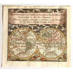
MappaMondo o sia Carta Generale del Globo Terestre Rappresentata in due Pian§Emisferi. . .
Beautiful small double hemisphere map decorated with clouds at the top and allegorical figures of the four continents: America the dangerous, strong Europe, exotic Asia, ...
Date: Antwerp: Jan Duren, 1697
Selling price: ????
Please login to see price!
Sold in 2015
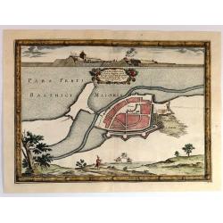
Nackschouia Lalandia Oppidium.
Old map of the Nakskov area of Denmark - Nakscoviae - by Pufendorf/ Dahlberg 1697. It is in Lolland municipality in Region Sjælland on the western coast of the island of...
Date: Sweden, 1697
Selling price: ????
Please login to see price!
Sold in 2017