Browse Listings
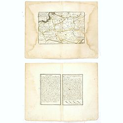
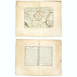
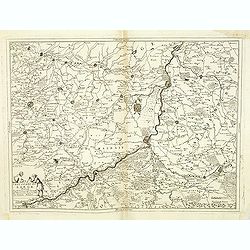
Ichnogrphia Nakscoviae.
Fine decorative map from Samuel Pufendorfs large description of the Swedish King Karl X Gustav's campaign in Poland, Germany and Denmark in the years 1655-1660. Erik Dahl...
Date: Sweden, 1697
Selling price: ????
Please login to see price!
Sold in 2018
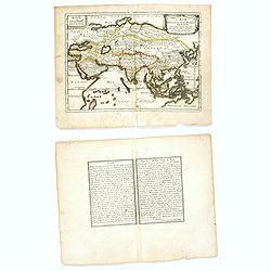
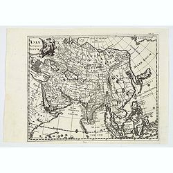
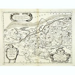
L'Asie Dressée Sur Divers Relations Par N. de Fer.
An interesting small map of Asia by Nicolas de Fer. From his rare "Petit et Nouveau Atlas". The first edition was published in 1697 and was republished in 1705 ...
Date: Paris, 1697
Selling price: ????
Please login to see price!
Sold in 2016
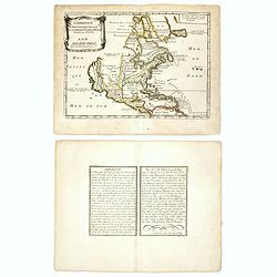
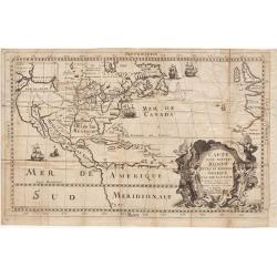
L'Amérique septentrionale et les terres polaires arctique (sic) / dressée par N. de Fer.
An interesting small map of North America by Nicolas de Fer. From his rare "Petit et Nouveau Atlas". The first edition was published in 1697 and was republished...
Date: Paris,1697
Selling price: ????
Please login to see price!
Sold in 2016
Estats de la Couronne de Pologne.
An interesting small map of Poland by Nicolas de Fer. Engraved by C.Inselin. From his rare "Petit et Nouveau Atlas". The first edition was published in 1697 and...
Date: Paris, 1697
Selling price: ????
Please login to see price!
Sold in 2017
Hongrie ou partie septent de la Turquie en Europe.
An interesting small map of Hungary and Bulgaria by Nicolas de Fer. Engraved by Inselin. From his rare "Petit et Nouveau Atlas". The first edition was published...
Date: Paris, 1697
Selling price: ????
Please login to see price!
Sold in 2018
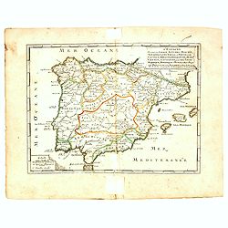
L'Espagne divisée en Galice Asturies Biscaye . . .
An interesting small map of Spain and Portugal by Nicolas de Fer. From his rare "Petit et Nouveau Atlas". The first edition was published in 1697 and was republ...
Date: Paris, 1697
Selling price: ????
Please login to see price!
Sold in 2017
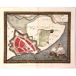
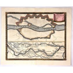
Ichnographia Rutcopiae Langelandice Oppidi
A beautifully engraved plan of the fortified town of Rutkioping on the Danish island of Langeland. Fully engraved sea with two large rowboats filled with sailors engaged ...
Date: Stockholm, 1697
Selling price: ????
Please login to see price!
Sold in 2018
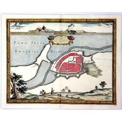
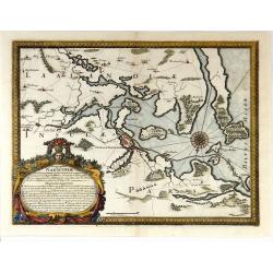
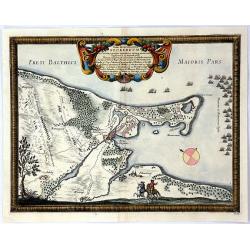
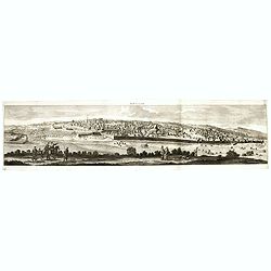
Nackschovia lulandiae Oppidum
A beautiful engraved plan of the fortified town of Nakskov Lolland Island in Demnark. Engraved on copper with a view of the fortress. With a floral title cartouche and pi...
Date: Stockholm, 1697
Selling price: ????
Please login to see price!
Sold in 2016
Situs Iocorum Circa Neoburgum in Fiona
A beautiful engraved plan of Nybirg Fyn in Demnark. Engraved on copper with a view of two men on horseback. With a decorative title cartouche and picture frame borders. A...
Date: Stockholm, 1697
Selling price: ????
Please login to see price!
Sold in 2018
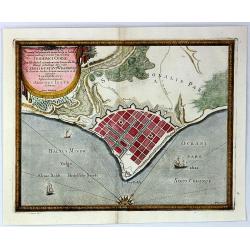
Accurata Delineatio Geometrica in Luthia Friderici Oddae
A striking map of Fredericia in Demnark. Engraved on copper with a view of three ships in the sea. With a decorative drapery title cartouche and picture frame borders. A...
Date: Stockholm, 1697
Selling price: ????
Please login to see price!
Sold in 2018
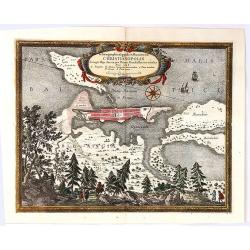
Ichnographia Oppidi et Munimenti Christianopolis ...
Kristianopel, at the eastern end of the province of Blekinge, was founded in 1603 by King Christian IV of Denmark as a defense against Swedish attacks. The province of Bl...
Date: Nuremberg, 1697
Selling price: ????
Please login to see price!
Sold in 2019
Brema.
Bremen town plan with course of the Wezer river the map is copperplate engraved with hand coloring and shows the hinterland of Bremen during the Swedish and the Bremen Th...
Date: Stockholm , 1697
Selling price: ????
Please login to see price!
Sold in 2017
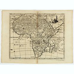
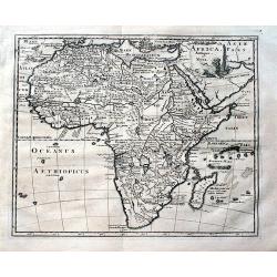
Africa antiqua et Nova.
Interesting map of Africa from Philipp Clüver's famous Introductionis in Universam geographicam, first published in Leiden in 1624. Philipp Clüver (1580–1623) was vir...
Date: Amsterdam, 1697
Selling price: ????
Please login to see price!
Sold in 2017
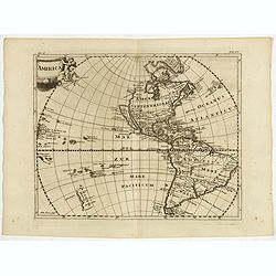
America.
Interesting map of America showing California as an island and completely omitting the Great Lakes. From Philipp Clüver's famous Introductionis in Universam geographicam...
Date: Amsterdam, 1697
Selling price: ????
Please login to see price!
Sold in 2017
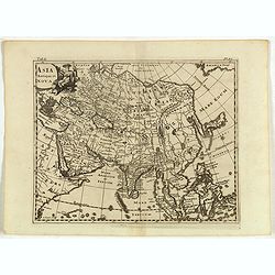
Asia Antiqua et Nova.
Interesting map of Asia from Philipp Clüver's famous Introductionis in Universam geographicam, first published in Leiden in 1624. Philipp Clüver (1580–1623) was virtu...
Date: Amsterdam, 1697
Selling price: ????
Please login to see price!
Sold in 2017
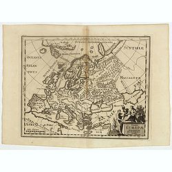
Summa Europae Antiquae descriptio.
Interesting map of Ancient Europe from Philipp Clüver's famous Introductionis in Universam geographicam, first published in Leiden in 1624. Philipp Clüver (1580–1623)...
Date: Amsterdam, 1697
Selling price: ????
Please login to see price!
Sold in 2018
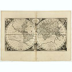
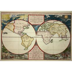
Typus Orbis Terrarum.
Interesting double hemisphere from Philipp Clüver's famous Introductionis in Universam geographicam, first published in Leiden in 1624. Philipp Clüver (1580–1623) was...
Date: Amsterdam, 1697
Selling price: ????
Please login to see price!
Sold in 2017
Aegyptus et Cyrene.
An attractive antique map of Egypt and Libya by Philip Cluver. It details the Mediterranean coast from the Red Sea to Libya and south to Garama. The coastal region of Lib...
Date: Paris, 1697
Selling price: ????
Please login to see price!
Sold in 2018
Africa antiqua et nova.
A fascinating map of Africa from Philipp Clüver's famous "Introductionis in Universam geographicam", which was first published in Leiden in 1624. Philipp Clüv...
Date: Amsterdam, 1697
Selling price: ????
Please login to see price!
Sold in 2018
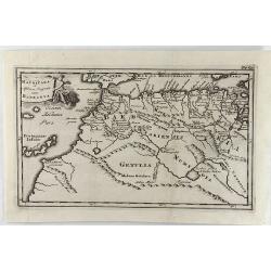
Mauritana et Africa Proria nunc Barbaria.
A pleasantly engraved map of the north-western part of Africa with the Canary Islands.
Date: Leiden, 1697
Selling price: ????
Please login to see price!
Sold in 2019
Asia Antiqua et Nova.
A nice, detailed map of Asia, with a decorative cartouche. Interesting because of its unusual configuration of the Philippines, Japan and Korea. From the eastern Mediterr...
Date: Leiden, 1697
Selling price: ????
Please login to see price!
Sold in 2019
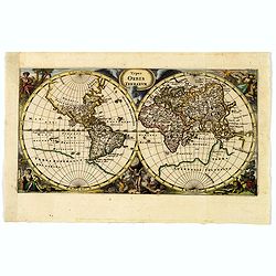
Typus Orbis Terrarum.
A very decorative world map showing the 'bulge' in South America, California as an peninsula and only a very rudimentary form of Australia. In fact, 'Terra Australis Inco...
Date: Amsterdam, ca 1697
Selling price: ????
Please login to see price!
Sold in 2019
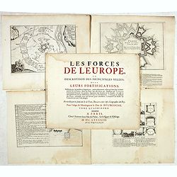
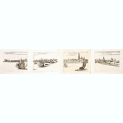
(Lot of 10 sheets) Les forces de l'Europe, ou description des principales villes . . .
Lot of 10 engravings showing fortification prepared by Sébastien Le Prestre, Seigneur de Vauban and later Marquis de Vauban (15 May 1633 – 30 March 1707).Commonly refe...
Date: Paris, c. 1697
Selling price: ????
Please login to see price!
Sold in 2019
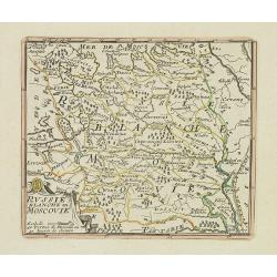
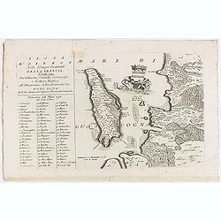
La Russie Blanche ou MOSCOVIE.
Scarce miniature map centered on Moscow, from the rare atlas " El atlas abreviado, o compendiosa geografia del mundo antiguo, y nuevo. . ." by Francesco de Affe...
Date: Antwerp, Jan Duren, 1698
Selling price: ????
Please login to see price!
Sold in 2012
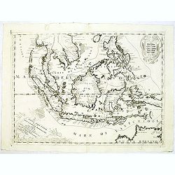
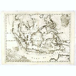
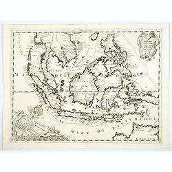
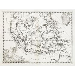
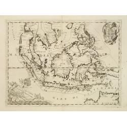
Isole Dell' Indie, diuise in Filippine, Molucche, e della Sonda . . .
A beautiful and flamboyantly engraved large-scale map of the East Indies, including the Malay Peninsula, Cambodia, the Philippines and all of Indonesia and the Spice Isla...
Date: Venice, 1698
Selling price: ????
Please login to see price!
Sold in 2012
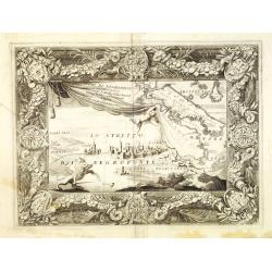
Regno di Negroponte Descritto e Dedicato al Reverendismo. P. Maestro Felice Rotondi . . .
A beautiful and flamboyantly engraved large-scale view of Chalkida (Halkida) with in the top right corner an inset map of the island of Evia. With a wide decorative flora...
Date: Venice, 1698
Selling price: ????
Please login to see price!
Sold in 2012
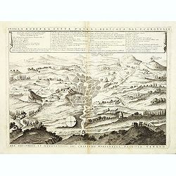
Antica e Moderna Citta d'Atene dedicata dal P. Coronelli. . .
A beautiful and flamboyantly engraved large-scale plan of Ancient Athenes. The map is the product of the late 17th century Venetian cartographer, Vincenzo Coronelli. A de...
Date: Venice, 1698
Selling price: ????
Please login to see price!
Sold in 2012
Iunan, Queicheu, e Quangsi Provincie della China . . .
Striking early map of the Chinese provinces of Iunan (Yunan), Queicheu (Guizhou), e Quangsi (Guangxi). With a highly decorative title and mileage-scale cartouches. In top...
Date: Venice, 1698
Selling price: ????
Please login to see price!
Sold in 2012
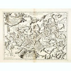
Vesvocato di Liege. . .
A beautiful and flamboyantly engraved large-scale map of the region Liege, Maastricht, Hasselt in Belgium and the Nethermlands.In the lower left the title cartouche with ...
Date: Venice, 1698
Selling price: ????
Please login to see price!
Sold in 2019
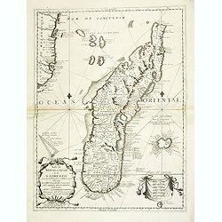
Isola di Madagascar, o di S. Lorenzo . . .
A beautiful and flamboyantly engraved large-scale map of Madagascar, formerly named San Lorenzo by the discoverers, the Portuguese. Shows also in detail the Comorra Islan...
Date: Venice, 1698
Selling price: ????
Please login to see price!
Sold in 2013
Contado di Namur . . .
A beautiful and flamboyantly engraved large-scale map of Namur region in central Belgium. Includes several coats of arms.On verso a map of the Malay Peninsula as far sout...
Date: Venice, 1698
Selling price: ????
Please login to see price!
Sold in 2019
![[No title] Nine views of Italian buildings, churches in Ravenna.](/uploads/cache/32808-250x250.jpg)
[No title] Nine views of Italian buildings, churches in Ravenna.
A page with nine views of buildings, churches and monuments in Ravenna.On verso a map of the Malay Peninsular as far south as Singapore. (215x275mm) With three small brow...
Date: Venice, 1698
Selling price: ????
Please login to see price!
Sold in 2012
Parte septtentrionale dell' Hollanda, vulgo Westuriesland en Tnoorder Quartier. . .
A beautifully engraved map of northern Netherlands or "West Friesland", including the towns of Amsterdam, Hoorn, Haerlem, t'Huys, Edam, etc. The region is fille...
Date: Venice, 1698
Selling price: ????
Please login to see price!
Sold
Xansi, e Xensi, provincie della China . . .
A beautiful and flamboyantly engraved large-scale map of Province of Xansi (Shanxi) and Xensi (Shaanxi) including a depiction of the Great Wall and the Deserto de Xamo. T...
Date: Venice, 1698
Selling price: ????
Please login to see price!
Sold in 2012
Xantung, e Peking provincie della china. . .
A beautiful map depicting the area of Beijing with decorative title cartouche and scale cartouche. Information about the area at the top of the map.To the right the west ...
Date: Venice, 1698
Selling price: ????
Please login to see price!
Sold in 2012
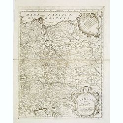
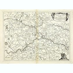
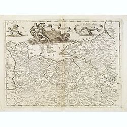
Parte orientale della Germania. . .
A beautiful and flamboyantly engraved large-scale map of Poland, Eastern part of Germany and Austria. On verso a map of the Malay Peninsular as far south as Singapore. (2...
Date: Venice, 1698
Selling price: ????
Please login to see price!
Sold in 2012
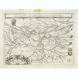
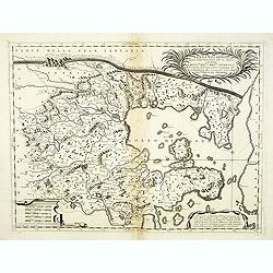
Il Ducato di mantova nella Lombardia. . .
A beautiful and flamboyantly engraved large-scale map of Mantova region in Lombardia. On verso letter press with a view of Lake Garda "Isole del Lago di Garda" ...
Date: Venice, 1698
Selling price: ????
Please login to see price!
Sold in 2017
![Parallelo Geografico dell'Antico col Moderno Arcipelago ... [in set with] Parte Meridionale dell' Arcipelago. . .](/uploads/cache/32827-250x250.jpg)
Parallelo Geografico dell'Antico col Moderno Arcipelago ... [in set with] Parte Meridionale dell' Arcipelago. . .
A beautiful and flamboyantly engraved large-scale map showing the Marmara Sea or Sea of Marmora (ancient Propontis), inland sea, north-western Turkey, connected to the Bl...
Date: Venice, 1698
Selling price: ????
Please login to see price!
Sold in 2012
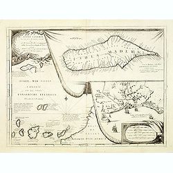
Isole Canarie. . .
Decorative and highly detailed map of the Islands of the Canaries and Madeira, with a large inset of the port of Funchal. Includes two decorative cartouches.On verso a vi...
Date: Venice, 1698
Selling price: ????
Please login to see price!
Sold in 2012
Isola d'Oleron.
A beautiful map showing the isle of Oleron, located in the Bay of Biscay off the coast of France, from Vincenzo Coronelli's Corso Geografico Universale.A numbered key of ...
Date: Venice, 1698
Selling price: ????
Please login to see price!
Sold in 2012
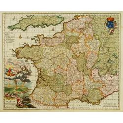
Ducato di Normandi.
A beautiful and flamboyantly engraved large-scale map of Normandy, with a fine title cartouche featuring Leda in her carriage drawn by swans.On verso are plans of Le Havr...
Date: Venice, 1698
Selling price: ????
Please login to see price!
Sold
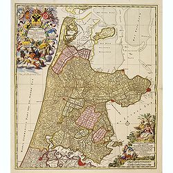
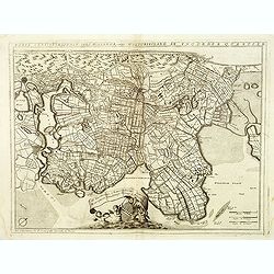
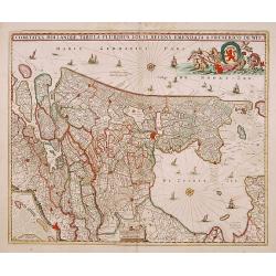
Kennemaria et Westfrisia vulgo et vernacule Noord Holland.
A most decorative map, in bright full original colors, of the northern part of Holland. At that time practically all polders -with the exception of the IJ-polder- had alr...
Date: Amsterdam, 1698
Selling price: ????
Please login to see price!
Sold in 2012
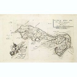
Isola del Re Nel Mare di Guascogna. . .
A beautiful map showing Ile de Ré in Bretagne, located in the Bay of Biscay off the coast of France, from Vincenzo Coronelli's Corso Geografico Universale.Italian text o...
Date: Venice, 1698
Selling price: ????
Please login to see price!
Sold
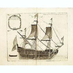
Nave di CIV. Cannoni Colle fue proportioni tagliata à mezzo per. . .
A beautiful and flamboyantly engraved large-scale map of a ship. On verso a map of the Malay Peninsular as far south as Singapore. (215x275mm) With three small brown spot...
Date: Venice, 1698
Selling price: ????
Please login to see price!
Sold in 2013
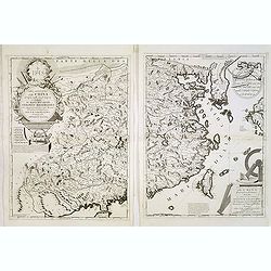
Parte occidentale della China / Parte orientale della China . . .
The two sheet map depicts the eastern part of China with Korea -correctly- as a peninsula. The maps are still on separate uncut sheets, each map measuring 607x450mm., tog...
Date: Venice, 1698
Selling price: ????
Please login to see price!
Sold in 2013
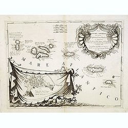
Isole Azzori, o Azzoridi. . .
A beautiful and highly decorative map of the Azores Islands. With large title cartouche in the upper right corner decorated with coral, fish, seaweeds and pearl chains.In...
Date: Venice, 1698
Selling price: ????
Please login to see price!
Sold in 2013
Veduta di Rotterdam (4 sheet view of Rotterdam)
A beautiful and flamboyantly engraved detailed panoramic view of Rotterdam. The Laurens Church, still with his wooden lantern [removed ca. 1650] upon the bell tower. A de...
Date: Venice, ca. 1698
Selling price: ????
Please login to see price!
Sold in 2014
Carte d'un Nouveau Monde, entre le Nouveau Mexique et la Mer Glaciale ...
Map of America from Nouveau Voyage d'un Pays plus grand que l'Europe ... by R. P. Louis Hennepin, published in Utrecht in 1698.Based on his 1683 map Carte de la Nouvelle ...
Date: Utrecht, 1698
Selling price: ????
Please login to see price!
Sold in 2014
Appendix Tab. III. Africae, Aegyptum Inferiorem Exhibens.
Map of the Nile delta based on the Ptolemaic model. Mercator originally published this map in his 1578 edition of Ptolemy's great Geography. Although he is most renowned ...
Date: Amsterdam, 1698
Selling price: ????
Please login to see price!
Sold in 2015
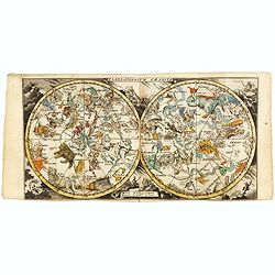
Plani-Spherium Coeleste.
Scarce miniature double celestial chart, from the rare atlas " El atlas abreviado, o compendiosa geografia del mundo antiguo, y nuevo. . ." by Francesco de Affe...
Date: Antwerp, Jan Duren, 1698
Selling price: ????
Please login to see price!
Sold in 2017
Ierusalem.
Panoramic view of Jerusalem as viewed from Mount of Olives with several figures in the foreground. Cornelis de Bruyn (1652-1726) was a painter who traveled through the Ho...
Date: Delft, Henrik van Krooneveld, 1698
Selling price: ????
Please login to see price!
Sold in 2018
Isole Dell' Indie, diuise in Filippine, Molucche, e della Sonda . . .
A beautiful and flamboyantly engraved large-scale map of the East Indies, including the Malay Peninsula, Cambodia, the Philippines and all of Indonesia and the Spice Isla...
Date: Venice, 1698
Selling price: ????
Please login to see price!
Sold in 2016
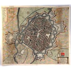
Ichnographia Munitissima Urbis Valentiae Quae Gallice Pronunciatur Valenciennes Belgice.
A detailed large bird's eye city view of Valenciennes, in France, by De Wit. The plan shows individual buildings, streets and trees. The map is adorned by a title cartouc...
Date: Amsterdam, 1698
Selling price: ????
Please login to see price!
Sold in 2016
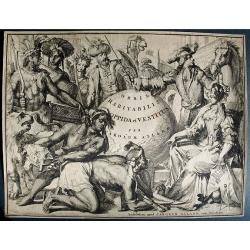
CAREL ALLARD, Orbis Habitabilis et vestitus. 1698
An ornate, elaborately engraved frontispiece from the only edition of the "extremely rare, much sought-after" town book by Carel Allard. A very dark impression ...
Date: Amsterdam, 1698
Selling price: ????
Please login to see price!
Sold in 2016
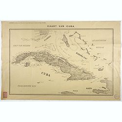
Kaart van Cuba. Bijvoegsel behoorende bij het 2e blad van de nieuwe Rotterdamsche Courant van Vrijdag 6 Mei 1898.
Lithographed map of Cuba, including southern tip of Florida with the Keys and the Bahama Islands. Several folds as issued, some underlaid with archival tape. Published as...
Date: Rotterdam, 1698
Selling price: ????
Please login to see price!
Sold in 2017
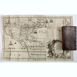
Nouveau Voyage d'un Pais Plus Grand que l'Europe.
FIRST EDITION OF THE BOOK. This edition of Hennepin's writings, a continuation of his Nouveau voyage of the previous year, comprises materials about La Salle taken from C...
Date: Utrecht, [E. Voskuyl for] Antoine Schouten, 1698
Selling price: ????
Please login to see price!
Sold
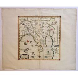
Tab. XI. Asiae, Comprehendens Indiam Extra Gangem.
This wonderful map illustrates the Ptolemaic concept of Malaya and Indochina, labeled 'India Extra Gangem' or 'India beyond the Ganges'. The map shows an oddly shaped Mal...
Date: Utrecht, 1698
Selling price: ????
Please login to see price!
Sold in 2017
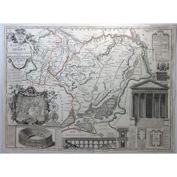
Diocese de Nismes.
A very busy map in the style of J.B. Nolan featuring Nismes in Belgium, and vignettes of its high points including the Amphitheatre, La Maison Quarrie, Temple de Dianne, ...
Date: Paris, 1698
Selling price: ????
Please login to see price!
Sold in 2018

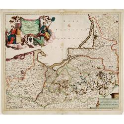
Ducatus Prussiae tam Polono Regiae. . .
This is a rare issue of Frederick de Wit's attractive map of the northern part of Poland, Prussia and the Baltic regions.Very decorative title cartouche, including three ...
Date: Amsterdam, 1698
Selling price: ????
Please login to see price!
Sold in 2024
Isole Dell' Indie, diuise in Filippine, Molucche, e della Sonda . . .
A beautiful and flamboyantly engraved large-scale map of the East Indies.
Date: Venice, 1698
Selling price: ????
Please login to see price!
Sold in 2018
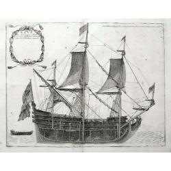
Nave di CIV. Cannoni. . .
A large cross-section view of a 17th century sailing ship. A very interesting and detailed print, with the cargo visible at the bottom and numerous cannons. From Coronell...
Date: Venice, ca 1698
Selling price: ????
Please login to see price!
Sold in 2018
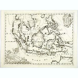
Isole Dell' Indie, diuise in Filippine, Molucche, e della Sonda . . .
A beautiful and flamboyantly engraved large-scale map of the East Indies, including the Malay Peninsula, Cambodia, the Philippines and all of Indonesia and the Spice Isla...
Date: Venice, 1698
Selling price: ????
Please login to see price!
Sold in 2018
Carte D'un Nouveau Monde, entre le Nouveau Mexique, et la Mer Glacialle Novellement decouvert par le R.P. Louis Hennepin...
Extremely rare second edition of Louis de Hennepin’s map of North America, which incorporates many of the discoveries omitted by Hennepin in the first edition of his ma...
Date: Paris, 1698
Selling price: ????
Please login to see price!
Sold in 2021
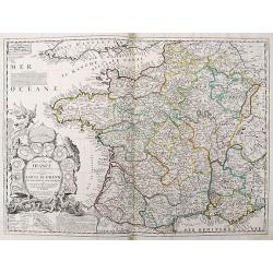
Le Royaume de France...
Well engraved 17th century copper engraved map of France. The large title cartouche is surrounded by a plan of Paris and 10 other cities in France.
Date: Paris, 1698
Selling price: ????
Please login to see price!
Sold in 2019
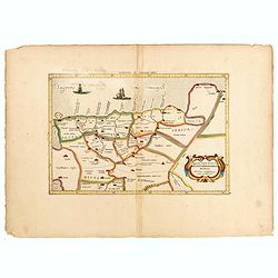
Comitatus Hollandiae tabula pluribus..
West to the top. Lower left inset of the Wadden Islands, Texel, Vlieland, Terschelling and part of Ameland.
Date: Amsterdam 1698
Selling price: ????
Please login to see price!
Sold
Galliae seu Franciae Tabula.
The map is decorated with a beautiful cartouche relating to Neptune and the four elements and with the French coat of arms.
Date: Amsterdam, ca. 1698
Selling price: ????
Please login to see price!
Sold
C.D. Bona Esperance.
A couple of Bona Esperance, published in the very rare work Orbis habitabilis oppida (N° 59).
Date: Amsterdam, 1698
Selling price: ????
Please login to see price!
Sold
Benedict. Arias Montanus Sacrae Geographiae Tabula..
This striking double hemisphere world map is a rare variant of Montanus' Polyglot Bible map of 1571/1572. Principally showing how Noah's three sons repopulated the world,...
Date: Amsterdam, 1698
Selling price: ????
Please login to see price!
Sold in 2008
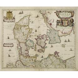
Regni Daniae Novissima et Accuratissima Tabula.
An uncommon issue of the magnificent map of all of Denmark and the tip of Sweden. The land is fully engraved with mountains, forests and cities, while the sea is filled w...
Date: Amsterdam 1698
Selling price: ????
Please login to see price!
Sold
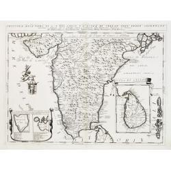
Penisola dell'Indo di qua del Gange, e l isola di Ceilan..
India below the Tropic of Cancer, with an insets of Ceylon and Trincomalee.The remarkable Vincenzo Coronelli (1650-1718), encyclopaedist, geographer, inventor and Doctor ...
Date: Venice 1698
Selling price: ????
Please login to see price!
Sold
Isole dell'Indie
A beautiful and flamboyantly engraved large-scale map of the East Indies, including the Malay Peninsula, Cambodia, the Philippines and all of Indonesia and the Spice Isla...
Date: Venice 1698
Selling price: ????
Please login to see price!
Sold
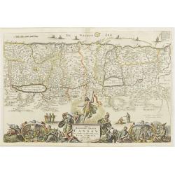
Promised land and Canaan.
Map of Israel/Palestine. The large bottom-cartouche shows the birth, death and resurrection of Christ, and the four evangelists with their symbols.
Date: Dordrecht, 1698
Selling price: ????
Please login to see price!
Sold in 2008
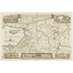
Middle-East.
Map of the middle-East four cartouches show life in, and expulsion out of paradise, another cartouche shows the Noah's Ark.
Date: Dordrecht, 1698
Selling price: ????
Please login to see price!
Sold
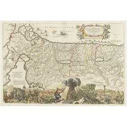
Palestine / Israel.
Map of Palestine and Israel. Large bottom-cartouche shows the 40-years expedition from the Sinai desert to the promised land, and Moses receiving the the tables of the 10...
Date: Dordrecht ,1698
Selling price: ????
Please login to see price!
Sold
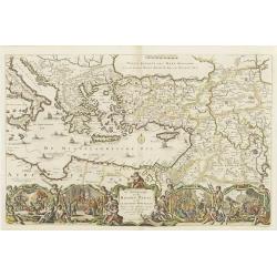
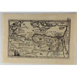
Eastern Mediterranian.
Map of Turkey, Greece, Middle-east, part of Italy and part of north-Africa. A large bottom-cartouche showing scenes from the life and travels of st.Paul.
Date: Dordrecht 1698
Selling price: ????
Please login to see price!
Sold
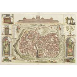
Jerusalem.
Map of Jerusalem and a view on the temple of Salomon. At the sides are cartouches of king Salomon and the high-priest, pictures of the arch of the covenant, tabernacle an...
Date: Dordrecht, 1698
Selling price: ????
Please login to see price!
Sold
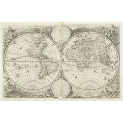
WereltCaert.
World-map, originally designed by Nicholas Visscher in 1663. Adapted by Keur and inserted in his bible in 1698. Very good world-map, in the four corners are representat...
Date: Dordrecht ,1698
Selling price: ????
Please login to see price!
Sold
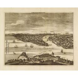
Constantinopolen.
A finely engraved prospect view of Constantinople (Istanbul) from above Scutari.Cornelis de Bruyn (1652-1726) was a Dutch portrait painter and traveler. He painted for so...
Date: Amsterdam, 1698
Selling price: ????
Please login to see price!
Sold in 2020
Ducatus Prussiae tam Polono Regiae..
Rare issue of Justus Danckert's attractive map of northern part of Poland.Decorative title cartouche upper left hand corner.
Date: Amsterdam, 1698
Selling price: ????
Please login to see price!
Sold in 2010
Isole dell'Indie.
A beautiful and flamboyantly engraved large-scale map of the East Indies, including the Malay Peninsula, Cambodia, the Philippines and all of Indonesia and the Spice Isla...
Date: Venice, 1698
Selling price: ????
Please login to see price!
Sold in 2010