Browse Listings
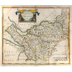
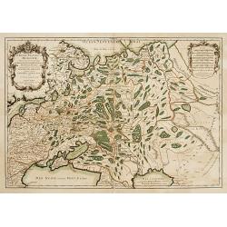
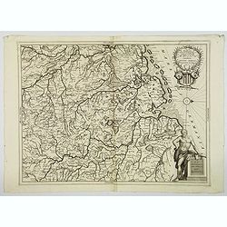
The County Palatine of Chester ...
This is the county map of Cheshire by Robert Morden. It shows an early road system with the town of Chester located on the left middle side of the map. There is a decorat...
Date: London, 1695
Selling price: ????
Please login to see price!
Sold in 2016
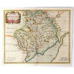
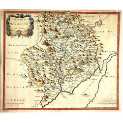
The County of Monmouth.
A detailed British county map by Robert Morden, from Camden's famous description of Great Britain, issued the late seventeenth century. Of particular interest is Morden's...
Date: London, 1695
Selling price: ????
Please login to see price!
Sold in 2016
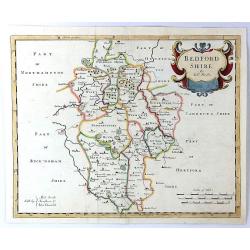
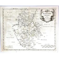
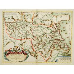
Bedfordshire by Robt. Morden
A detailed British county map by Robert Morden from Camden's famous description of Great Britain, issued the late seventeenth century. Of particular interest is Morden's ...
Date: London, 1695
Selling price: ????
Please login to see price!
Sold in 2018
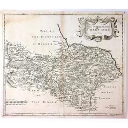
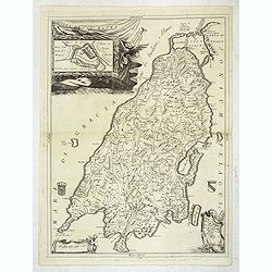
The North Riding of Yorkshire
A detailed British county map by Robert Morden from Camden's famous description of Great Britain, issued the late seventeenth century. Of particular interest is Morden's ...
Date: London, 1695
Selling price: ????
Please login to see price!
Sold in 2016
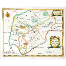
Comitatus Rotelandiae Tabula Nova & Aucta
An attractive, detailed map of the county of Rutland, England’s smallest county. The map was engraved by Robert Morden, and published in "Camden's Britannia"....
Date: London, 1695
Selling price: ????
Please login to see price!
Sold in 2016
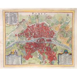
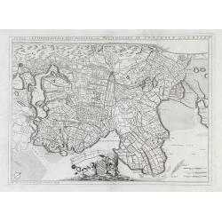
PARIS
A plan of the city of Paris, by N. de Fer, around 1695 - 1742. Published in "Les forces de l'Europe, ou description des principales villes...".
Date: Paris, ca 1695
Selling price: ????
Please login to see price!
Sold in 2016
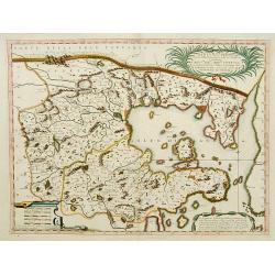
The County of Monmouth
A pleasing first edition map of Monmouthshire by Robert Morden from his "CAMDEN'S BRITANNIA, published by Swale, Awnshaw & Churchil in London in 1695. Features a...
Date: London, 1695
Selling price: ????
Please login to see price!
Sold in 2016
Bedfordshire
A pleasing first edition map of Bedfordshire by Robert Morden from his "CAMDEN'S BRITANNIA, published by Swale, Awnshaw & Churchil in London in 1695. It features...
Date: London, 1695
Selling price: ????
Please login to see price!
Sold in 2016
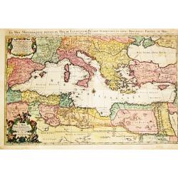
![Parte orientale dell' Europa . . . [Eastern part of Europe with Russia and map of Iceland on verso]](/uploads/cache/39638-250x250.jpg)
Parte orientale dell' Europa . . . [Eastern part of Europe with Russia and map of Iceland on verso]
Eastern part of Europe of a two sheet map. On the verso a map of Iceland "Isola d'Islanda". The Europe map extends from the Turkey (with Cyprus) and the Black s...
Date: Venice, 1695
Selling price: ????
Please login to see price!
Sold in 2020
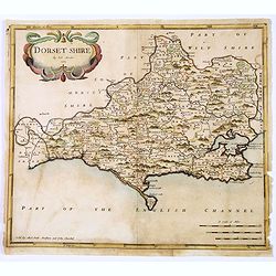
Dorsetshire.
A first edition county map of Dorsetshire by the English cartographer Robert Morden, published in his "Camden's Britannia" in London in 1695. An attractive titl...
Date: London, 1695
Selling price: ????
Please login to see price!
Sold in 2018
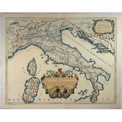
L'Italia con le Sue Poste e Strade Principali.
A beautiful map of Italy featuring its Post Routes and Highways. This elegant chart of Italy extends to show the Adriatic, some of the Balkans, west to include Provence t...
Date: Rome, 1695
Selling price: ????
Please login to see price!
Sold in 2018
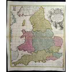
A New Mapp of the Kingdome of England, Representing the Princedome of Wales, and other Provinces, Cities, Market Towns, with the Roads from Town to Town.
A very rare map of England, originally made by Nicolaes Visscher in 1695 and also sold by John Overton.The map focuses on the distances between cities and market towns (l...
Date: Amsterdam, 1695
Selling price: ????
Please login to see price!
Sold in 2018
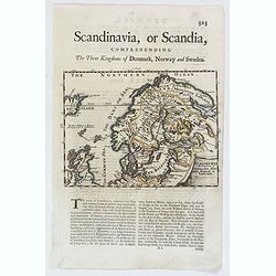
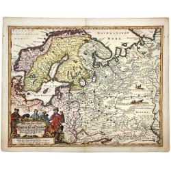
Scandinavia or the Kingdoms of Denmark, Sueden, Norway & Lapland.
A nice late seventeenth century map of Scandinavia, as it was then. It depicts Sweden occupying modern day Finland, and shows part of Iceland, England and Ireland, all of...
Date: London, 1695
Selling price: ????
Please login to see price!
Sold in 2018
Nova Ducatus et praefecturae Normanniae..
Uncommon map of Russia. Decorated with large title and scale cartouches.
Date: Paris 1695
Selling price: ????
Please login to see price!
Sold
Xantun, e Peking..
An attractive map of this northern province. Curiously, although Peking had been thus named since the 15th century (after a spell as Kublai Khan's Cambaluc ), it is here ...
Date: Venice, 1695
Selling price: ????
Please login to see price!
Sold
![Straet Davis en Hudson [Portrait of two locals]](/uploads/cache/06034-250x250.jpg)
Straet Davis en Hudson [Portrait of two locals]
Rare print of two locals of Canada, probably from Allard's Orbis Habitabilis Oppida et Vestitus.
Date: Amsterdam 1695
Selling price: ????
Please login to see price!
Sold
Nanking, et Honan provincie della China..
An attractive map of this north eastern province of China. Including the town of Kiangning, in contemp. manuscript ou Nankin. The remarkable Vincenzo Coronelli (1650-1718...
Date: Venice, 1695
Selling price: ????
Please login to see price!
Sold
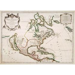
Amérique septentrionale divisée en ses principales parties..
Engraved by Cordier. Spectacular example of Jaillot's map of North America, showing California as an Island, based upon Sanson's landmark map of 1656. This map shows the ...
Date: Paris, 1695
Selling price: ????
Please login to see price!
Sold

Prospectus Commandariae Gemert.
One of the earliest views of the Castle of Gemert.
Date: Amsterdam, 1695
Selling price: ????
Please login to see price!
Sold in 2017
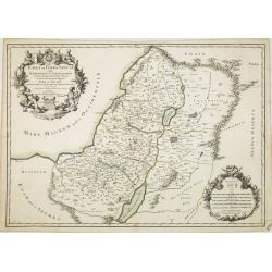
Judaea seu Terra Sancta quae Hebraeorum sive Israelitarum..
Map of the Holy Land divided into the 12 Tribes of Israel on both sides of the Jordan, the shoreline running from Sidon to Gaza. Drawn after Guillaume Sanson. Engraved by...
Date: Paris, 1695
Selling price: ????
Please login to see price!
Sold in 2008
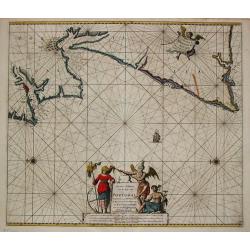
Nieuwe Paskaart Van de Kust van Portugal beginnende 3 a 4 Myl Benoorde C. Roxeur, tot aen C.d.S.Vincente.
Johannes van Keulen is the founder of the successful van Keulen firm that published charts, pilot guides and sea-atlases for over 2 centuries. In 1680 he published his im...
Date: Amsterdam, c. 1695
Selling price: ????
Please login to see price!
Sold
Xantun, e Peking..
An attractive map of this northern province. Curiously, although Peking had been thus named since the 15th century (after a spell as Kublai Khan's Cambaluc ), it is here ...
Date: Venice 1695
Selling price: ????
Please login to see price!
Sold
Parte orientale della China.. / Parte occidentale della China (2 sheets)
The map depicts the eastern part of China with Korea -correctly- as a peninsula. Formosa is included as well. Japan is partly visible i.e. the area of Yamaguchi, strait K...
Date: Venice 1695
Selling price: ????
Please login to see price!
Sold
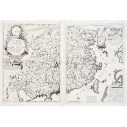
![[Two maps] Parte settentrionale dell' Irlanda descritta.. / Irlanda Parte Meridionale..](/uploads/cache/23418-250x250.jpg)
[Two maps] Parte settentrionale dell' Irlanda descritta.. / Irlanda Parte Meridionale..
A two sheet map of Ireland. The remarkable Vincenzo Coronelli (1650-1718), encyclopaedist, geographer, inventor and Doctor of Theology, was citizen of the Republic of Ven...
Date: Venice 1695
Selling price: ????
Please login to see price!
Sold
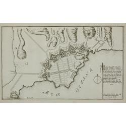
Gothebourg ...
Charming bird's-eye plan of the fortification of the city of Gothenburg on the west coast of Sweden.Nicolas de Fer held the title of Geographer at Louis XIV's court. He w...
Date: Paris, 1695
Selling price: ????
Please login to see price!
Sold in 2011
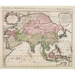
L'Asie divise en ses Principales regions. . .
Attractive large-scale map of Asia. This map is based extensively on Sanson, but prepared and published by Hubert Jaillot. The confusion concerning the area north to Japa...
Date: Paris, 1695
Selling price: ????
Please login to see price!
Sold in 2015
![[Coronelli's 2 sheet map of Europe] Parte Occidentale dell' Europa? / Parte orientale dell' Europa . . .](/uploads/cache/29154-250x250.jpg)
[Coronelli's 2 sheet map of Europe] Parte Occidentale dell' Europa? / Parte orientale dell' Europa . . .
Fine map of Europe including Russia, Ukraine and the Caspian Sea, and includes 2 decorative cartouches with dedication to Giovanni da Mula. The coast of North America in ...
Date: Venice, 1695
Selling price: ????
Please login to see price!
Sold in 2012
![[Coronelli's 2 sheet map of Asia] Parte Occidentale dell' Asia. . . / Parte orientale dell' Asia . . .](/uploads/cache/29155-250x250.jpg)
[Coronelli's 2 sheet map of Asia] Parte Occidentale dell' Asia. . . / Parte orientale dell' Asia . . .
Map of Asia.The remarkable Vincenzo Coronelli (1650-1718), encyclopaedist, geographer, inventor and Doctor of Theology, was citizen of the Republic of Venice. He was also...
Date: Venice, 1695
Selling price: ????
Please login to see price!
Sold in 2010
![Parte orientale dell' Europa . . . [Russia]](/uploads/cache/29452-250x250.jpg)
Parte orientale dell' Europa . . . [Russia]
Eastern part of Europe. The map extends from the Turkey (with Cyprus) and the Black sea, Ukraine and part of the Caspian Sea, up till Nova Zembla. Only the west coast of ...
Date: Venice, 1695
Selling price: ????
Please login to see price!
Sold in 2010
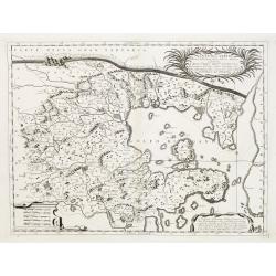
Parte Septtentrionale Dell'Hollanda, vulgo Westuriesland en Tnoorder Quartier. . .
Detailed map of the West Friesland region of northwestern Holland by Vincenzo Coronelli that shows the cities of Amsterdam and Haarlem af the left side of the map.. This ...
Date: Venice, 1695
Selling price: ????
Please login to see price!
Sold in 2010
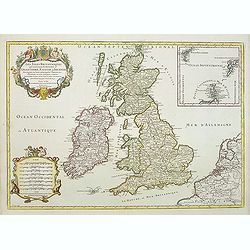
Les Isles Britanniques ou sont le R.me d'Angleterre.. d'Ecosse.. d'Irlande.
RARE, according Shirley a fourth state with erased date but still with Jaillot's name in the dedication followed by his title as royal geographer. With address "Ché...
Date: Paris, after 1695
Selling price: ????
Please login to see price!
Sold in 2011
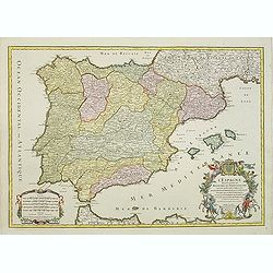
L\'Espagne divisée en tous ses Royaumes et Principautées. . .
RARE state with erased date but still with Jaillot's name in the dedication followed by his title as royal geographer. With address "Chéz H.Jaillot, joignantles gra...
Date: Paris, after 1695
Selling price: ????
Please login to see price!
Sold in 2011
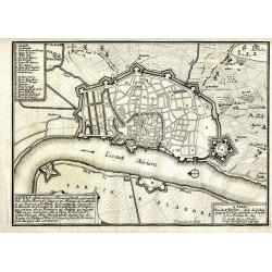
ANVERS, Antwerpen...
De Fer's scarce copper engraved plan of the foritified city and the surrounding area. Engraved by Harmanus van Loon. Shows the streets and city walls, the fields and road...
Date: Paris, 1695
Selling price: ????
Please login to see price!
Sold in 2011
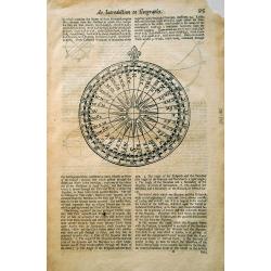
An Introduction to Geography.
A nice woodcut engraving of a compass rose (sometimes called a wind rose or rose of the winds). Made by an anonymous engraver, ca. 1695. The rose is surrounded by English...
Date: Unknown, ca 1695
Selling price: ????
Please login to see price!
Sold in 2019
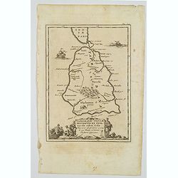
Taprobanae Insulae Descriptio ex Ptol. Incolae eidem Salae. . .
The uncommon and pleasant map of Taprobana (Sri Lanka) and the southern tip of India is based on the work of Ptolemy. It shows only ancient place names and is embellished...
Date: Utrecht, ca 1695
Selling price: ????
Please login to see price!
Sold in 2020
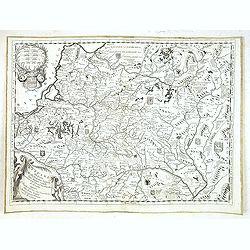
La Vestfalia, detta altrimenti. Die Westpalen.
A delightful map that shows the Westphalian Circle between the estuary arms of the Rhine over the islands from Ameland to Wangeroog, the Weser Run to Kassel in northwest ...
Date: Venice, 1695
Selling price: ????
Please login to see price!
Sold in 2021
Disegno Idrografico del Canale Reale . . .
A decorative Coronelli map showing the Canal du Midi. It shows the extent of the canal from the Mediterranean sea at Narbonne to Toulouse. Featuring a pair of large coats...
Date: Venice, 1695
Selling price: ????
Please login to see price!
Sold in 2020
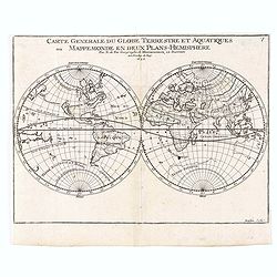
Carte generale du Globe Terrestre Aquatiques.
Double hemisphere showing California as an island. A great southern continent is partially outlined. Published by Nicolas De Fer, Royal French Geographer.
Date: Paris, 1695
Selling price: ????
Please login to see price!
Sold in 2020

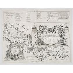
Vertrek van S.K.H. NA Engeland den 11. Nov. 1688 & Aenkomst van S.K.H.D.P. van Orangie in Engeland, den 15. en 16. Nov. 1688. . .
Two large engraved views on one sheet, illustrating the departure of William III of Orange with his large fleet from Holland (Hellevoetsluis), and his arrival at Brixham,...
Date: Amsterdam, ca 1695
Selling price: ????
Please login to see price!
Sold in 2021
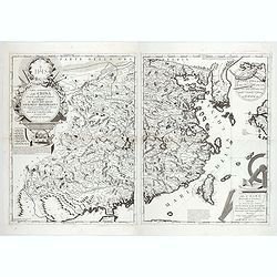
Parte orientale della China.. / Parte occidentale della China (2 sheets)
The map depicts the eastern part of China with Korea -correctly- as a peninsula. Formosa is included as well. Japan is partly visible i.e. the area of Yamaguchi, strait K...
Date: Venice, 1695
Selling price: ????
Please login to see price!
Sold in 2022
![[ Lot of 11 maps of northern Germany]](/uploads/cache/19075-(1)-250x250.jpg)
[ Lot of 11 maps of northern Germany]
[Lot of 11 maps] of northern Germany. -Oost-Frise ou le Comte D'Embden. -Aquisgranum vulga aich per…… -Cercles de Haute Et Basse Saxe. -Oldenburg Comitatus. -...
Date: Amsterdam, 1695
Selling price: ????
Please login to see price!
Sold in 2023
An attractive large-format map showing the whole of the Mediterranean. Embellished with a large title-cartouche and a large cartouche with scales.
Alexis-Hubert Jaillot (1632-1712), French cartographer. He joined the Sanson heirs and redrew Nicolas Sanson's maps on a larger scale. 'Atlas Nouveau' (1674), sea-atlas '...
Date: Amsterdam, 1695
Selling price: ????
Please login to see price!
Sold in 2022
![[2 sheets] Parte Settentrionale del' IRLANDA... [with] IRLANDA Parte Meridionale. . .](/uploads/cache/83234-250x250.jpg)
[2 sheets] Parte Settentrionale del' IRLANDA... [with] IRLANDA Parte Meridionale. . .
A matching set in contemporary Italian original color (contemporary colored maps of Coronelli are very rare on the market) of 2 attractive large folio maps depicting the ...
Date: Venice, 1696
Selling price: ????
Please login to see price!
Sold in 2019
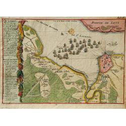
Quebec, Ville de l'Amerique Septentrionale dans la Nouvelle France.
A second state of the early map of Quebec by Nicolas de Fer. The maps illustrates Sir William Phips' attack on Quebec in 1690. Following his success at Port Royal, Phips ...
Date: Paris, 1696
Selling price: ????
Please login to see price!
Sold in 2019
Land und see charter Schleswig vist nach Muctau. . .
An attractive and detailed map of north east Europe, with Scandinavia and part of Russia. With a striking cartouche of Merchants and Traders in local costume. Adam Oleari...
Date: Hamburg, 1696
Selling price: ????
Please login to see price!
Sold in 2020
![[2 text pages with views of Fort Zeelandia on Taiwan]](/uploads/cache/83711-250x250.jpg)
[2 text pages with views of Fort Zeelandia on Taiwan]
Each page with a depiction of a sea battle offshore Fort Zeelandia on Taiwan. The "81" page in September 1661. The Siege of Fort Zeelandia of 1661-1662 ended th...
Date: Hamburg, 1696
Selling price: ????
Please login to see price!
Sold in 2020
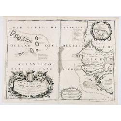
Bocche del Fiume Negro et Isole di Capo Verde. . .
This is a splendid map of the northwestern coast of Africa and the Cape Verde Islands.The map provides details of the various Portuguese discoveries in the region in the ...
Date: Venice, 1696
Selling price: ????
Please login to see price!
Sold in 2020
Contado di Zara . . .
Striking map depicting the administrative territory of the Adriatic coasts taken between Istria and Albania and it represents one of the first thematic maps about the org...
Date: Venice, 1696
Selling price: ????
Please login to see price!
Sold in 2020
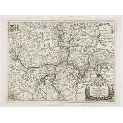
Marchesato del sacro impero e signoria di Malines . . .
Large-folio map of the region around the Brabant cities of Leuven, Brussels, Mechelen, Antwerp and Dendermonde. Richly decorated with cartouches and coats of arms.Vincenz...
Date: Venice, 1696
Selling price: ????
Please login to see price!
Sold in 2020
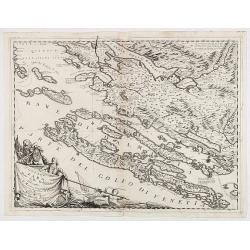
Disegno topografico del canale di Cattaro . . .
Decorative and highly detailed map of a portion of the Gulf of Venice and Sea of Dalmatia, in the Hercag-Novi region of Serbia and Montenegro. A remarkable engraving, wit...
Date: Venice, 1696
Selling price: ????
Please login to see price!
Sold in 2020
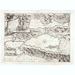
Ristretto Della Dalmazia Divisa Ne Suoi Contadi Gia Presentata Alla Serenissima Republica Di Venezia . . .
Elaborate map of the coast of Dalmatia.From Coronelli's rare Atlante Veneto, one of the most decorative and ornate of all 17th century atlases. Engraved in Coronelli's un...
Date: Venice, 1696
Selling price: ????
Please login to see price!
Sold in 2020
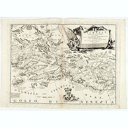
Stato di Ragusi Bocca del fiume Narenta, Isole di Lesina . . .
Map of the Republic of Dubrovnik. It shows the territory of the Republic of Dubrovnik, which included the greater Dubrovnik area comprising the mouth of the river Neretva...
Date: Venice, 1696
Selling price: ????
Please login to see price!
Sold in 2020
Bosforo tracio, hoggidi Canale di Costantinopoli, descritto dal P. Cosmografo Coronelli secondo le memorie di Monsieur Galland.
Map of The Bosporus, with Istanbul lower left. The map is set in an ornate border.From Coronelli's rare Atlante Veneto, one of the most decorative and ornate of all 17th ...
Date: Venice, 1696
Selling price: ????
Please login to see price!
Sold in 2020
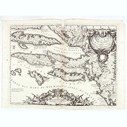
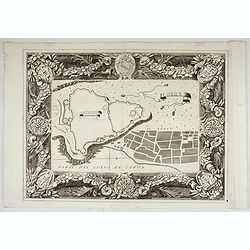
Regno di Negroponte Descritto e Dedicato al Reverendismo. P. Maestro Felice Rotondi . . .ok
A beautiful and flamboyantly engraved large-scale view of Chalkida (Halkida) with in the top right corner an inset map of the island of Evia. With a wide decorative flora...
Date: Venice, 1696
Selling price: ????
Please login to see price!
Sold in 2021
![Pianta della Forterra d'ATENE. . . [Athens]](/uploads/cache/45626-250x250.jpg)
Pianta della Forterra d'ATENE. . . [Athens]
A scarce town-plan showing the fortress and city of Athens, mainly concentrating on classical sites within the city, with a very fine separately printed border consisting...
Date: Venice, 1696
Selling price: ????
Please login to see price!
Sold in 2020
Contea dell' Artesia. Dedicata All' Illustriss, et Eccellentis: S. Bartolomeo Grimani Dal P. Coronelli.
Map of north of France, including Callais From the "Atlante Farnese". In 1683 the Venetians invaded Greece trying to wrest control from the Turks. Starting in t...
Date: Venice, 1696
Selling price: ????
Please login to see price!
Sold in 2020
Delineatio Geometrica Urbis Haffniae Daniae Regum.
A bird's-eye plan of the important fort defending Copenhagen. The Danish navy fills the sea, and the map is adorned with decorative title and key cartouches and a detaile...
Date: Stockholm, 1696
Selling price: ????
Please login to see price!
Sold in 2020
Delineatio Geometrica Urbis Haffniæ, Daniæ Regum ...
Detailed copper engraved map featuring a panoramic view of Copenhagen, Capital of Denmark, besieged by Swedish forces from 11th (21st) August 1658. This time instead of c...
Date: Nuremburg, 1696
Selling price: ????
Please login to see price!
Sold in 2020
Ichnographia Areis et Oppidi Nicoplae.
A striking city map of Nykobilg, Denmark by Pufendorf in 1696. Freiherr Samuel von Pufendorf (1632–1694) was a German jurist, political philosopher, economist and histo...
Date: Stockholm, 1696
Selling price: ????
Please login to see price!
Sold in 2023
Amerique meridionale divisee en ses principales.
An attractive large-format map of the South American continent, embellished with two large cartouches. Newly engraved for the counterfeited edition of the 'Atlas Nouveau'...
Date: Amsterdam, 1696
Selling price: ????
Please login to see price!
Sold in 2022
Coron. Parte del Golfo di Coron.
Map of Coron island. The map is set in an ornate border.From Coronelli's rare Atlante Veneto, one of the most decorative and ornate of all 17th century atlases. Engraved ...
Date: Venice, 1696
Selling price: ????
Please login to see price!
Sold in 2022
![[Lot of two maps of Europe]](/uploads/cache/19546-(1)-250x250.jpg)
[Lot of two maps of Europe]
An attractive large-format map of the European continent, embellished with a large title-cartouche. Newly engraved for the counterfeited edition of the ' Atlas Nouvea...
Date: Amsterdam, 1696
Selling price: ????
Please login to see price!
Sold in 2022
Lituania dedicata all. Illustrissimo signore Gio. Pietro Caualli secretario della serenissima Republica di ...
A scarce and very attractive detailed map of Lithuania and parts of Poland and the Baltic and includes numerous coats of arms in the body of the map and two large decorat...
Date: Venice, 1696
Selling price: ????
Please login to see price!
Sold in 2012
![Pianta della Forterra d'ATENE. . . [Athens]](/uploads/cache/31821-250x250.jpg)
Pianta della Forterra d'ATENE. . . [Athens]
A scarce town-plan showing the fortress and city of Athens, mainly concentrating on classical sites within the city, with a very fine separately printed border consisting...
Date: Venice, 1696
Selling price: ????
Please login to see price!
Sold in 2012
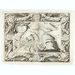
Isola e Regno di Candia. . .
A scarce and very attractive detailed two sheet map of Crete within wide garland of vines incorporating the names of 100 Cretan towns, coat-of-arms of Cardinal d' Estrée...
Date: Venice, 1696
Selling price: ????
Please login to see price!
Sold in 2012
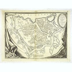
Pianta Della Real Fortezza e Citta di Candia. . .
City of Candia showing its fortifications. A beautifully ornate map with a rich, dark impression and a decorative border depicted as a hanging tapestry.The remarkable Vin...
Date: Venice, 1696
Selling price: ????
Please login to see price!
Sold
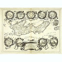
Isola di Corfu.
One of the most attractive maps of the island of Corfu ever produced. The central map is surrounded by nine plans and views of fortified locations and the ancient city of...
Date: Venice, 1696
Selling price: ????
Please login to see price!
Sold in 2014
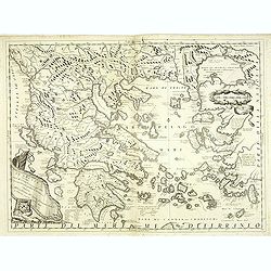
La Grecia descritta dal P. M. Coronelli Cosmografo della Serenissima Repubblica si Venezia dedicata all'Eccellenza del Signor Giovanni Lando.
Map of Greece and its islands in the Aegean and Adriatic Seas. The remarkable Vincenzo Coronelli (1650-1718), encyclopaedist, geographer, inventor and Doctor of Theology,...
Date: Venice, 1696
Selling price: ????
Please login to see price!
Sold in 2012
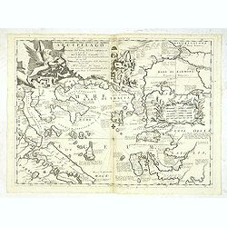
Paralello geo grafico dell'antico col moderno Arcipelago
A beautiful and rare map showing the Marmara Sea or Sea of Marmora (ancient Propontis), inland sea, north-western Turkey, connected to the Black Sea by the Bosporus Strai...
Date: Venice, 1696
Selling price: ????
Please login to see price!
Sold in 2012
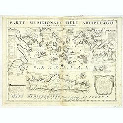
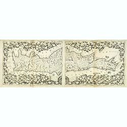
Parte Meridionale deli Archipelago. . .
A scarce and very attractive detailed map of Crete and the Aegean Sea. Forming a set with lot 31826The remarkable Vincenzo Coronelli (1650-1718), encyclopaedist, geograph...
Date: Venice, 1696
Selling price: ????
Please login to see price!
Sold in 2012
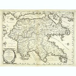
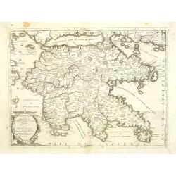
Peloponneso hoggidi Morea. . .
Decorative and highly detailed map of Morea, southern Greece with title cartouche lower left.The remarkable Vincenzo Coronelli (1650-1718), encyclopaedist, geographer, in...
Date: Venice, 1696
Selling price: ????
Please login to see price!
Sold in 2013
Isola di S. Maura.
A scarce and very attractive detailed map of S. Maura, with a dedication to Matteo Sanudo. With inset map. The remarkable Vincenzo Coronelli (1650-1718), encyclopaedist, ...
Date: Venice, 1696
Selling price: ????
Please login to see price!
Sold
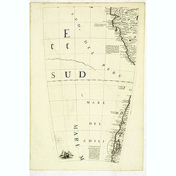
(Globe gore) Della citta di Chiloe. . .
Globe segment published in 1696 as part of the atlas entitled "Libri dei Globi". The page contains part of the west coast of Chili and Peru. This atlas containe...
Date: Venice, 1696
Selling price: ????
Please login to see price!
Sold in 2012
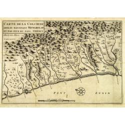
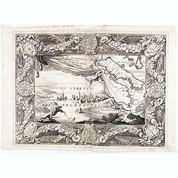
Carte de la Colchide appelée maintenant Mengrelie et par ceux du pays Odisci.
An early map showing the extent of the fortifications of the Ottoman Empire along the east of the Black Sea and in the foothills of the Caucasus. Vignettes of buildings, ...
Date: Paris, 1664-1696
Selling price: ????
Please login to see price!
Sold in 2012
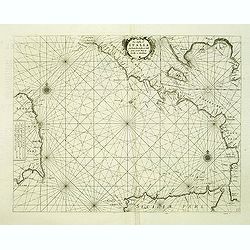
La costa d'Italia da Porto Hercole sino a C. dell'Arme et una parte di Sicilia et Sardinia.
Elaborate and scarce chart of the Tyrrhenian Sea with the north coast of Sicily and the east coast of Sardinia originally made for "Prima Parte dello Specchio del Ma...
Date: Venice, 1696
Selling price: ????
Please login to see price!
Sold in 2012
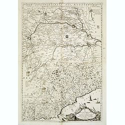
Il Monferrato. . .
A beautiful and flamboyantly engraved large-scale map of Monferrato including the towns of Turin, Casale, Alessandria, Ovada, etc. The map is the product of the late 17th...
Date: Venice, ca. 1696
Selling price: ????
Please login to see price!
Sold in 2015
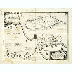
Isole Canarie. . .
Decorative and highly detailed map of the Islands of the Canaries and Madeira, with a large inset of the port of Funchal. Includes two decorative cartouches.On verso Ital...
Date: Venice, ca.1696
Selling price: ????
Please login to see price!
Sold in 2012
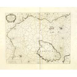
Carta Maritima della Costa Ligustica fra C. delle Melle e M. Argentato con l'Isola di Corsica et altre circonvicine. . .
A beautiful and flamboyantly engraved large-scale sea, showing Corsica and Mediterranean Sea. On verso Italian letter press and engraved plans of Antibes (130x160mm.) and...
Date: Venice, 1696
Selling price: ????
Please login to see price!
Sold in 2012
Peloponneso, hoggidi Morea,. . .
A beautiful and flamboyantly engraved large-scale map of Morea, who was in 1683 invaded by the Venetians. The map carries a dedication to Marcello Sacchetti, ambassador f...
Date: Venice, ca. 1696
Selling price: ????
Please login to see price!
Sold
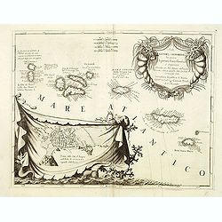
Isole Azzori, o Azzoridi. . .
A beautiful and highly decorative map of the Azores Islands. With large title cartouche in the upper right corner decorated with coral, fish, seaweeds and pearl chains.In...
Date: Venice, ca. 1696
Selling price: ????
Please login to see price!
Sold in 2014