Browse Listings
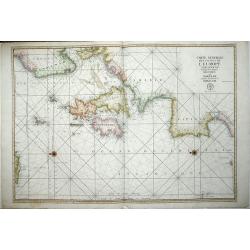
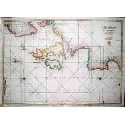
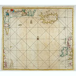
Carte generale des costes de l\'Europe sur l\'Ocean comprises depuis Dronthem en Norvege jusques au Destroit de Gibraltar.
An important sea chart of the Atlantic coasts of Europe, from Trondheim in Norway to the Straits of Gibraltar and the British Isles.The title at upper right is accompanie...
Date: Paris 1693
Selling price: ????
Please login to see price!
Sold in 2012
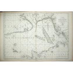
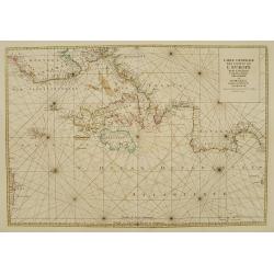
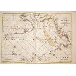
Carte de la Mer D\'Allemagne Contentant les Bancs Isles et Coftes Comprifes depuis Bergen et les Isles Schetland jufques au Pas de Calais.
A large chart of the North Sea showing the coastlines of eastern Britain and parts of Norway, Denmark, Germany and the Netherlands. North is oriented to the left of the p...
Date: Paris, 1693
Selling price: ????
Please login to see price!
Sold in 2012
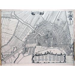
Amsterdam met des selfs omleggende landen.
Late 17th city plan of Amsterdam, from "Beschryvinge van Amsterdam, (...)," by Casparus Commelin. Very detailed plan of the city showing fields, fortifications,...
Date: Amsterdam, 1693
Selling price: ????
Please login to see price!
Sold in 2012
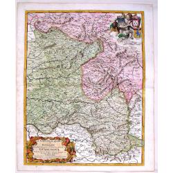
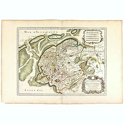
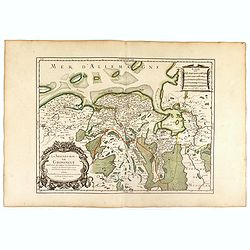
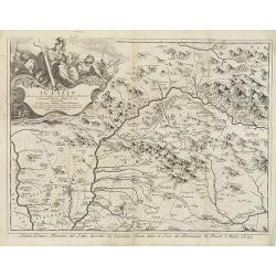
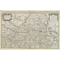
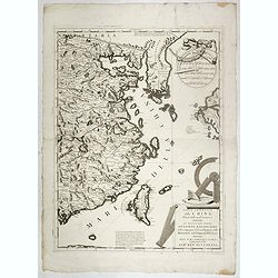
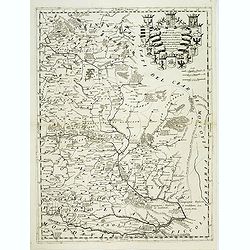
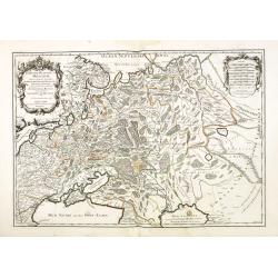
Il Limosino, Il Quercy e la Rovergue che Costituiscono Parte del Gouverno Generale di Guascogna
Highly detailed copper engraved map of Limousin & Quercy, regions located in Central France. The map includes the cities of Montauban, Villefranche sur Saonne, Limoge...
Date: Modena, 1693
Selling price: ????
Please login to see price!
Sold in 2015
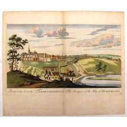
The Prospect of the Abby of Dumeermling.
Hand-colored, topographical engraving by John Slezer from "THEATRUM SCOTIAE", published in Scotland in 1693. This publication contained the prospects of their m...
Date: Edinburgh, 1693
Selling price: ????
Please login to see price!
Sold in 2018
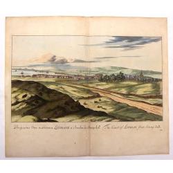
The Coast of Lothian from Stony Hill.
Hand-colored, topographical engraving by John Slezer from "THEATRUM SCOTIAE", published in Scotland in 1693. This publication contained the prospects of their m...
Date: Edinburgh, 1693
Selling price: ????
Please login to see price!
Sold in 2019
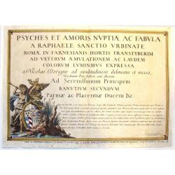
Psyches et Amoris nuptiae ac fabula a Raphaele (Title Page)
Fine copper engraved frontispiece by Nicolas Dorigny from "LOGGIA DI PSYCHE", was published in Rome in 1693.This engraving reproduces the frescoes by Raphael on...
Date: Rome, 1693
Selling price: ????
Please login to see price!
Sold in 2023
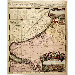
Carte Maritime des Environs de DIEPPE depuis PONT ASSELANE
From the first edition of Mortier's Neptune François showing the mouth of the Seine and inset panoramic views of Dieppe and Rouen. According to Koeman: ...the most expen...
Date: Amsterdam, 1693
Selling price: ????
Please login to see price!
Sold in 2015
La seigneurie d'ouest-Frise ou Frise Occidentale . . .
Fine map of the Friesland with a decorative title and scale cartouche.Alexis-Hubert Jaillot (1632-1712), was a French cartographer. He joined the Sanson heirs and redrew ...
Date: Paris, 1693
Selling price: ????
Please login to see price!
Sold in 2016
La Seigneurie de Groningue . . .
Fine map of the Groningen in the northern part of the Netherlands with a decorative armorial cartouche and small scale.Alexis-Hubert Jaillot (1632-1712), was a French car...
Date: Paris, 1693
Selling price: ????
Please login to see price!
Sold in 2016

Introduction a la Fortification Dediee a Monseigneur le Duc de Bourgogne, Title Page
A fine copper engraved Title Page by Nicolas De Fer, featuring his large publication detailing plans of military fortifications.With a central armorial, flanked above by ...
Date: Paris, 1693
Selling price: ????
Please login to see price!
Sold in 2017
Carte generale des costes de l'Europe sur l'Ocean comprises depuis Dronthem en Norvege jusques au Destroit de Gibraltar.
A very large, decorative, and important sea chart of the Atlantic coasts of Europe, from Trondheim in Norway to the Straits of Gibraltar and the British Isles. The title ...
Date: Paris, 1693
Selling price: ????
Please login to see price!
Sold in 2019
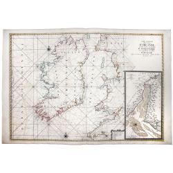
Carte Generale des Costes D'IRLANDE, et des Costes Occidentales D' ANGLETERRE avec une Partie de celles D' ECOSSE.
A magnificent chart of Ireland and the British Coast from Plymouth in Cornwall to Ayr in Scotland. A detailed inset chart of the River Dee as far as Holt is included in t...
Date: Paris, 1693
Selling price: ????
Please login to see price!
Sold in 2019

St Tropez.
Early plan of St.Tropez. From his "Introduction à la fortification".
Date: Paris, 1693
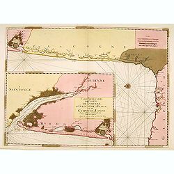
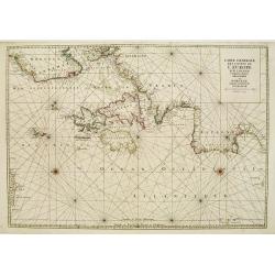
Carte Particulière des Costes de Guienne..
From the "Neptune Français", two charts on one sheet, in lower left showing the mouth of the Gironde till Bordeaux. The main chart depicting the coast of Gasco...
Date: Paris (Amsterdam), 1693
Selling price: ????
Please login to see price!
Sold
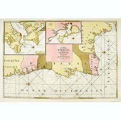
Carte des Costes de Portugal et de Partie d'Espagne depuis..
From the "Neptune Français", chart of southern part of Portugal, orientated east to the top. With insets of Lisbon and Cadiz.From Mortier's "Nep...
Date: Paris (Amsterdam), 1693
Selling price: ????
Please login to see price!
Sold
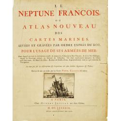
Title page : Le Neptune François.
Fine title page, size of paper 56x44cm. From the first edition of Mortier's Atlas Maritime, Neptune François, one of the most spectacular cartographical works ever produ...
Date: Amsterdam, 1693
Selling price: ????
Please login to see price!
Sold
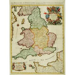
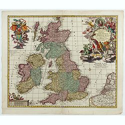
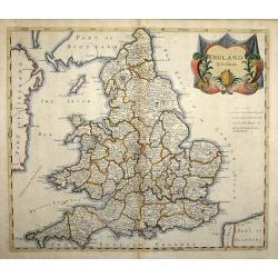
Le Royaume d'Angleterre distingué en ses provinces.
Fine map of England and Wales that is fully and richly engraved. Large and extremely decorative cartouche with angels, flags, seal of England, etc. Six distance scales wi...
Date: Paris 1693
Selling price: ????
Please login to see price!
Sold
Carte Maritime de L'Angleterre depuis les Sorlingue jusques à Portland..
From the first edition of Mortier's Atlas Maritime, showing Cornwall and inset panoramic view of Portland.From Mortier's Neptune François , one of the most spectacular c...
Date: Amsterdam 1693
Selling price: ????
Please login to see price!
Sold
Carte générale des costes de l'Europe sur l'Ocean comprises depuis Dronthem en Norvege jusques au Detroit de Gibraltar.
From the first edition of Mortier's Atlas Maritime, showing the coasts of Western Europe.From Mortier's Neptune François , one of the most spectacular cartographical wor...
Date: Amsterdam 1693
Selling price: ????
Please login to see price!
Sold
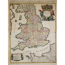
Le Royaume D' Angleterre distingué en ses Provinces.
Alexis-Hubert Jaillot (1632-1712), French cartographer. he joined the Sanson heirs. He redrew Nicolas Sanson's maps on a larger scale. 'Atlas Nouveau' (1674), sea-atlas '...
Date: Amsterdam, 1693
Selling price: ????
Please login to see price!
Sold in 2010
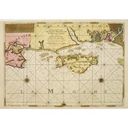
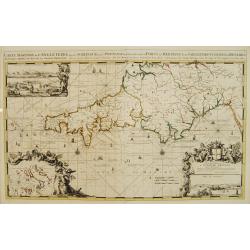
Carte Particulière des Costes Meridionales d'Angleterre qui comprend L'Isle de Wicht..
Superb sea chart of the Isle of Wight and the South Hampshire coast between Bournemouth and Portsmouth. Three elaborate compass roses and rhumb lines grace the chart. Fro...
Date: Paris, (Amsterdam), 1693
Selling price: ????
Please login to see price!
Sold
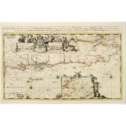
Carte nouvelle des costes d'Angleterre depuis la riviére de la Tamise jusques à Portland, & des Isles voisines..
Fine chart from the first edition of Mortier's Atlas Maritime, showing the south eastern coast of England, with river Thames.From Mortier's Neptune François , one of the...
Date: Amsterdam 1693
Selling price: ????
Please login to see price!
Sold

Frontispiece : Le Neptune François.
Impressive frontispiece engraved by Jan van Vianen, from the first edition of Mortier's Atlas Maritime, Neptune François.This was one of the most spectacular cartographi...
Date: Amsterdam 1693
Selling price: ????
Please login to see price!
Sold
Carte generale des costes de L'Europe sur l'Ocean comprises depuis Dronthem en Norvege jusques au Destroit de Gibraltar.
This general chart of the coast of Western Europe extends from the region west of Tronheim, Norway to about where Casablanca is on the coast of North Africa. It includes ...
Date: Paris 1693
Selling price: ????
Please login to see price!
Sold
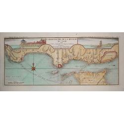
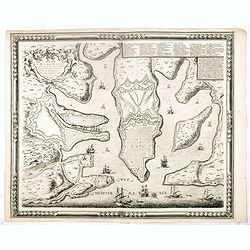
Embouchure de la Riviere du Tage.
A rare, finely engraved chart of the Lisbon coastline with insets of the Royal Palace and the Tower of Belem. The work also shows nearby towns such as Estoril and Cascais...
Date: Paris, ca. 1693
Selling price: ????
Please login to see price!
Sold in 2011
Il Lazio . . .
A uncommon, late 17th century map of the province of Rome, called the Lazio Region, based on the reports of Giacomo Cantelli da Vignola and published in Rome by Domenico ...
Date: Rome, 1693
Selling price: ????
Please login to see price!
Sold in 2009
Carte de la Mer d'Allemagne contenant les Bancs Isles et Costes comprises depuis Bergen et les Isles Schetland jusques au Pas De Calais
Large sea chart of the North Sea shows the coast lines of Norway from Bergen south to the Skagerrak, of the west coast of Denmark, the North Sea coast of Germany, Holland...
Date: Amsterdam, 1693
Selling price: ????
Please login to see price!
Sold in 2009
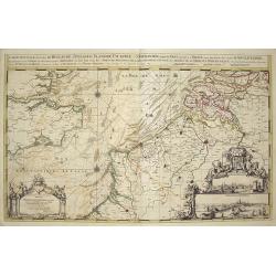
Carte Nouvelle des Costes de Hollande, Zéelande, Flandre, Picardie & Normandie,...
Large chart of the Dutch, Belgian and northern French Coastlines, along with part of the English Channel and the southwest coast of England. Includes large views of Calia...
Date: Amsterdam, 1693
Selling price: ????
Please login to see price!
Sold in 2010
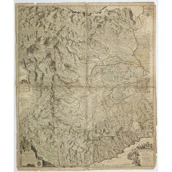
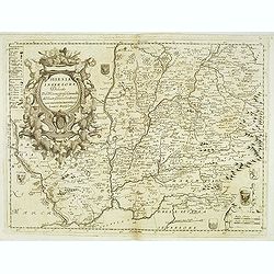
Partie du cercle d'Austriche sçavoir l'Archiduché d'Austriche . . .
Very large map of part of modern-days Austria, showing parts of Slovak Republic, Czech Republic and Hungary. The map is fully and richly engraved. Large and extremely dec...
Date: Amsterdam, 1693
Selling price: ????
Please login to see price!
Sold in 2015
Principauté d'Onéglia Marquisat de Final et Partie du Piemont du Monferrat et de la Republique de Genes . . .
A wall map of the Piedmont region and the hills of Montferrat and the Republic of Genoa.The Most Serene Republic of Genoa (Italian: Repubblica di Genova, Ligurian: Repúb...
Date: Paris, 1693
Selling price: ????
Please login to see price!
Sold in 2019
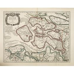
Le Comté de Zeelande . . .
Fine map of the province of Zeeland ornated with a rococo title cartouche with the coat of arms of Zeeland showing a lion half-emerged from water.Boundaries outlined in h...
Date: Paris, 1693
Selling price: ????
Please login to see price!
Sold in 2010
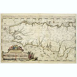
Carte Nouvelle des Costes De Bretagne depuis St. Malo jusques a l'emboucheure de la Riviere de Loire. . .
Chart of the French province of Brittany. From the first edition of Mortier's Atlas Maritime, showing the whole of Brittany and inset panoramic views of St.Malo, Brest, C...
Date: Amsterdam, 1693
Selling price: ????
Please login to see price!
Sold in 2011
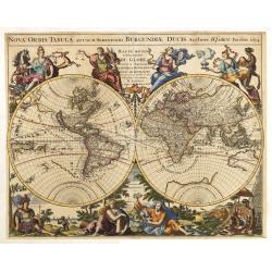
Nova Orbis Tabula, adusum Serenissimi Burgundiae..
The decorative world map was prepared by Hubert Jaillot for his 'Atlas Royal' which was first published by de Fer in 1695. Eight large allegorical figures are shown each ...
Date: Paris, 1694
Selling price: ????
Please login to see price!
Sold in 2018
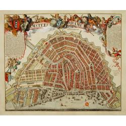
Amstelodamum cum antiquis et Neperrimis pomoeriis.
A very decorative and rare bird's-eye view of the town. The plan shows the garden plots of the patrician houses lining the Heren-, Keizers- and Prinsengracht in contrast ...
Date: Amsterdam 1694
Selling price: ????
Please login to see price!
Sold
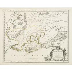
Cimmeria quae Postea Scythia Europaea..
Fine map of the northern part of the Black Sea.
Date: Paris, 1694
Selling price: ????
Please login to see price!
Sold
Den Aardkloot van water ontbloot, na twee zijden aante sien.
Uncommon map of the world, shown as if the oceans were dried up. California is an island, with a single Great Lake, and Australia is partially formed.From a Dutch edition...
Date: Amsterdam, 1694
Selling price: ????
Please login to see price!
Sold in 2011
![Urbis Edinae Facies Meridionalis Septentrionale. [ Edinburgh]](/uploads/cache/27803-250x250.jpg)
Urbis Edinae Facies Meridionalis Septentrionale. [ Edinburgh]
Two engraved panoramic views on one double-page engraved map sheet, key below each view. The town seen from the north and south. Title in Latin and English. Rare early vi...
Date: Amsterdam, ca. 1694
Selling price: ????
Please login to see price!
Sold in 2009
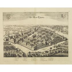
Die Stadtt Leijptzig.
Engraved bird's-eye town-plan of Leipzig, with key (1-26) in German below. Frederick de Wit published after 1694 a town book of European and Asian cities (Theatrum Praeci...
Date: Amsterdam, ca. 1694
Selling price: ????
Please login to see price!
Sold in 2013
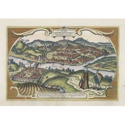
Buda Citerioris Hungariae Caput Regni avita sedes, vulgo Ofen.
Shows the Hungarian capital of Budapest. Originally engraved for the Civitates. Compiled and written by George Braun, Canon of Cologne Cathedral. The drawings was made by...
Date: Amsterdam, ca. 1694
Selling price: ????
Please login to see price!
Sold in 2009
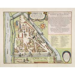
? Kremlenagrad Castellum Urbis Moskuae.
Detailed bird's-eye view of the Kremlin from Frederick de Wit's rare town book. With a key (1-20) to important spots in town. Frederick de Wit published after 1694 a town...
Date: Amsterdam, ca. 1694
Selling price: ????
Please login to see price!
Sold in 2009
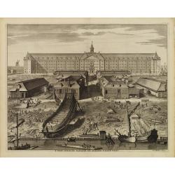
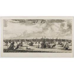
T' Oost indische Magazyn en scheeps-timmer-werf.
The V.O.C. warehouse and arsenal for the Admiralty of Amsterdam, now-a-days the Scheepvaartmuseum (Maritime Museum).In the foreground the shipyard and the print is giving...
Date: Amsterdam, 1694
Selling price: ????
Please login to see price!
Sold in 2015
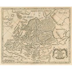
Summa Europae antique descriptio.
Small historical map of Europe.
Date: Wolfenbuttel, 1694
Selling price: ????
Please login to see price!
Sold in 2010
Accurata Utopiae Tabula Das ist Der Neu entdeckten Schalck Welt, oder des so offtbenannten, und doch nie erkanten Schlarraffenlandes Neu erfundene lächerliche Land tabell Worinnen alle und jede laster in besondere Königreich. . .
This curious and decorative Utopia map was printed for the art dealer and publisher Daniel Funck at the end of the seventeenth century together with a comprehensive expla...
Date: Nuremberg, 1694
Selling price: ????
Please login to see price!
Sold in 2020
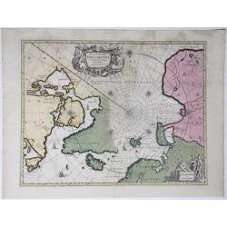
Nova et Accurata Poli Arctici et Terrarum Circum Iacentium Descriptio.
Map of the North Pole and surrounding countries. Title in a decorated cartouche at top; impresses in a cartouche with an ice bear and hunters at bottom right: 'Amstelodam...
Date: Amsterdam, 1694
Selling price: ????
Please login to see price!
Sold in 2020
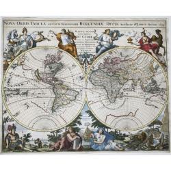
Nova orbis tabula, ad usum serenissimi Burgundiae ducis.
A finely engraved double-hemisphere map of the world with fine, full hand color with the title in a banner across the top edges, and surrounded by an elaborate allegorica...
Date: Paris, 1694
Selling price: ????
Please login to see price!
Sold in 2021
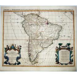
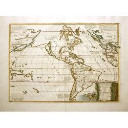
L'Amerique Meridionale Divisee en ses Principales Parties. . .
A handsome large-format map of South America by Jaillot, based upon the earlier maps of Nicholas Sanson. From: 'Atlas Royal', Amsterdam, 1694.Jaillot’s map is well-fram...
Date: Amsterdam, 1694
Selling price: ????
Please login to see price!
Sold in 2021
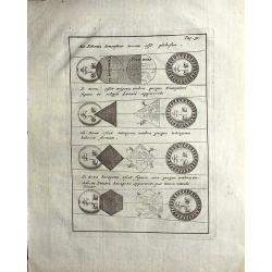
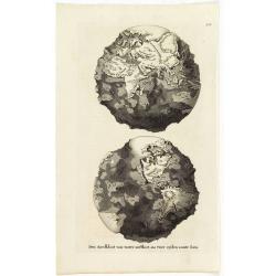
Hoc-Schema demonstrat terram esse globosam.
This fascinating sheet, from Cluver's "Introductionis in Universam Geographiam" contains the demonstration that the Earth is a globe. Several diagrams, in fact,...
Date: Amsterdam, 1694
Selling price: ????
Please login to see price!
Sold in 2021
Wassende Graade Kaart van de Noord Oceaan – Van Terra Nova en de Straat Davids en Hudsons tot Hidland en de Westkust van Schotland en Engeland en Bretagne begrypende ook Yrland en Ysland.
Very decorative sea chart by J. Van Keulen, shows the North Atlantic, including Ireland, Iceland, and a portion of the coasts of Greenland, the Faroe Islands, a portion ...
Date: Amsterdam, 1694
Selling price: ????
Please login to see price!
Sold in 2022
Magnae Britaniae Tabula; Comprehendens Angliae, Scotiae, Ac Hiberniae Regna . . .
Rare Dutch map of the British Isles in very attractive full original color. In this state the wording "Scilly Isles" is added. A decorative title cartouche in t...
Date: Amsterdam, after 1694
Selling price: ????
Please login to see price!
Sold in 2023
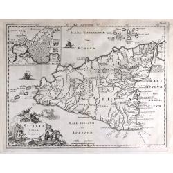
SICILIA INSULA.
Scarce decorative map of Sicily by Samuel Bochart with inset of the city of Syracuse. French early linguist Bochart (1599-1667) indicates, according to his firm convictio...
Date: Leiden, 1694
Selling price: ????
Please login to see price!
Sold in 2023
Atlantis Insula a Nicolao Sanson Antiquitati Restituta..
This is Sanson's unusual composition showing ancient geography within a contemporary outline of the Americas, which is noted in the cartouche as the mythical island of At...
Date: Padua, 1694
Selling price: ????
Please login to see price!
Sold in 2012
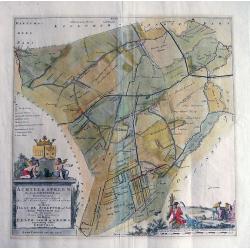
ACHTKERSPELEN De sesde Grietenie van Ooster-goo...
Unusual copper engraving published in the 'Portrayal of Heerlijheit Friesland' by François Halma in 1718. Large scale map showing towns such as Rottevalle, Drogeham, Sur...
Date: Amsterdam, after 1694
Selling price: ????
Please login to see price!
Sold in 2013
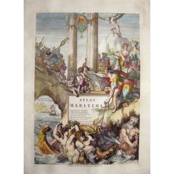
Atlas Maritime. (Title page)
Marvellous and huge frontispiece to the Atlas Maritime, published by Pieter Mortier in 1693 Amsterdam. It is signed by Romanus de Hooghe J.U. D. et Com Rég. Tab: hanc f...
Date: Amsterdam, 1694
Selling price: ????
Please login to see price!
Sold in 2014
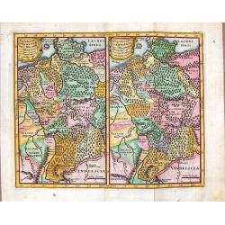
Populorum Germaniae Inter rhenum et Albim Descript.
Interesting two maps on one sheet covering the same area (nearly all of current Germany)showing subtle differences in the boundaries and place names during the Roman peri...
Date: Paris, 1694
Selling price: ????
Please login to see price!
Sold in 2018
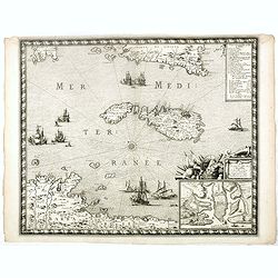
Plan de l'isle de Malte levée sur les lieux par le Sieur de Langres, Ingenieur du Roy soubz les Ordres de Monseigneur le Vicomte Darpaion lors général dans Malte.
Decorative and rare plan of Valletta, prepared by Sébastien de Pontault de Beaulieu (1612-1674). An fine plan of Valletta and Harbour, and the surrounding area, showing ...
Date: Paris, 1680 - 1694
Selling price: ????
Please login to see price!
Sold in 2017
Carte Et Plan de L'Isle de Malthe Et des Villes et forts avec le nouvelles fortification ainsy quellesont apresent.
Decorative and rare map of Malta and Gozo, prepared by Sébastien de Pontault de Beaulieu (1612-1674). The islands are shown in a bird's eye perspective from the coast of...
Date: Paris, 1680 - 1694
Selling price: ????
Please login to see price!
Sold in 2016

Plan de la ville, cite universite et fauxbourgs de Paris comme il est jourddhuy. . ..
One of the most sought after large plans of the city of Paris of the XVII century. Extremely important and decorative.On the top left, and the bottom right and left, are ...
Date: Paris, 1694
Selling price: ????
Please login to see price!
Sold in 2016
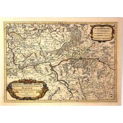
Partie Occidentale du Temporel de / l' Archeversche et Eslectorat de Mayence et le Haut et Bas Comte de Catzenellenboge
A large attractive map showing Mainz and Frankfurt along the course of the Rhine River, by N. Sanson in 1692, with a fine baroque title and scale cartouches. From “ Les...
Date: Paris, 1694
Selling price: ????
Please login to see price!
Sold in 2019
Den Aardkloot van water ontbloot, na twee zijden aante sien ("The Entire Planet Devoid of Water, Seen on Two Sides")
An uncommon map of the world, shown as if the oceans were dried up. California is an island, with a single Great Lake, and Australia is partially formed.From a Dutch edit...
Date: Amsterdam, 1694
Selling price: ????
Please login to see price!
Sold in 2020
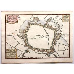
Mons.
Fine engraved map featuring the encampment of Mons, France. Features a detailed drapery cartouche and two other informational cartouches. Engraved by H. Van Loon. Nicolas...
Date: Paris , 1694
Selling price: ????
Please login to see price!
Sold in 2018
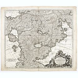
Parte orientale della China..
The map depicts the eastern part of China with Korea -correctly- as a peninsula. A lettered index (A=G) at mid-right, in the sea., Decorative cartouche with scientific in...
Date: Venice, 1694
Selling price: ????
Please login to see price!
Sold in 2018

Belgii novi, angliae novae, et partis Virginiae . . .
This example is state 3 of the original Janssonius plate, printed after Schenk acquired the plates at public auction in 1694 from the heirs of Jansson van Waesberge. The ...
Date: Amsterdam, 1694
Selling price: ????
Please login to see price!
Sold in 2025
Amsterdam aan de Waterkant vanaf 't IJ te Sien.
A panoramic view of the town from 't IJ. Engraved by Daniël Stoopendaal.Dare to go in Black. All early maps were printed in black and white; many were kept that way for ...
Date: Amsterdam, 1694
Selling price: ????
Please login to see price!
Sold in 2023
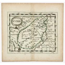
NUBIE (NUBIA)
Nubie old, outlined colored historical miniature map of Nubia along the Nile river located in what is today northern Sudan and southern Egypt. The map is copperplate engr...
Date: Nuremberg, 1694
Selling price: ????
Please login to see price!
Sold in 2020
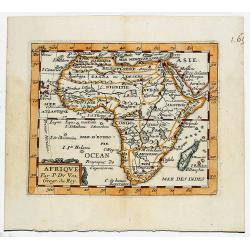
AFRIQUE. Par. P. DuVal. Geogr du Roy.
Map of Ancient Egypt, outlined and bordered colored historical miniature map of Africa. The map is copperplate engraved with hand coloring and in very good condition and...
Date: Paris, 1694
Selling price: ????
Please login to see price!
Sold in 2020
Polonia parte Orientale.
Uncommon map of the Ukraine, all engraved in Coronelli's strong and distinctive style. In upper right corner a imposing dedicational cartouche surmounted by coats of arms...
Date: Venice, 1695
Selling price: ????
Please login to see price!
Sold in 2012
Silesia Inferiore. . .
Uncommon map of lower Silesia engraved in Coronelli's strong and distinctive style. In upper right corner a imposing dedicational cartouche surmounted by coats of arms an...
Date: Venice, 1695
Selling price: ????
Please login to see price!
Sold in 2012

Provinces-Unies des Pays-Bas. . .
A large and most beautiful map of the Netherlands with two decorative title cartouches, fighting ships on the sea: a very decorative map, prepared by N.Sanson and publish...
Date: Paris, c.1695
Selling price: ????
Please login to see price!
Sold in 2015
Universalis Tabula juxta Ptolemaeum ...
This map is the revised second state of Mercator's 1578 Ptolemaic world map. The border has been re-engraved, and now includes a frieze of allegorical figures representin...
Date: Amsterdam/Leiden, 1695
Selling price: ????
Please login to see price!
Sold in 2013
Leicestershire.
Fine, detailed English county map by Morden. Decorative title and scale cartouches. Robert Morden (c.1650-1703) was an English bookseller, publisher, and maker of maps a...
Date: London, 1695
Selling price: ????
Please login to see price!
Sold in 2014
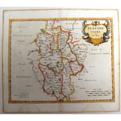
Bedfordshire.
County map of Bedfordshire by Morden. Nice cartouche. Published for "Camden's Britannia" Robert Morden (c.1650-1703) was an English bookseller, publisher, and ...
Date: London, 1695
Selling price: ????
Please login to see price!
Sold in 2013
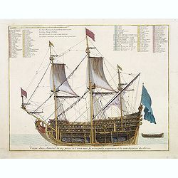
Coupe dun Amiral de 104 pieces de Canon avec ses principales proportions et les noms des pieces du dedans.
Fine double-page engraved plate of a naval vessel. Etched by Jan van Vianen. From Mortier's "Neptune François". From Mortier's famous maritime Atlas "Nept...
Date: Amsterdam, 1695
Selling price: ????
Please login to see price!
Sold in 2023
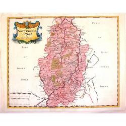
Nottinghamshire.
Striking copperplate map of Nottinghamshire showing details of cities, towns, rivers, roads and forests. Fine cartouche in left top corner. Robert Morden (c.1650-1703) wa...
Date: London, 1695
Selling price: ????
Please login to see price!
Sold in 2015
Comitatus Rotelandiae Tabula Nova & Aucta.
Nice 17th century copper engraved map featuring the Rutland county in England. Features the cities of Okeham & Uppingham and has two fancy Rococco title & descrip...
Date: London, 1695
Selling price: ????
Please login to see price!
Sold in 2015
La Russie Blanche ou Moscovie..
European Russia, including Poland and Ukraine. The relief of the landscape is shown and the regions are distinguished by kingdoms, dukedoms, principatlities, provinces an...
Date: Paris, ca. 1695
Selling price: ????
Please login to see price!
Sold in 2013
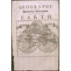
\"A Particular Description of The Known Parts Of The Earth\"
Interesting 1701 double hemisphere world map from Moll's 'A System of Geography', with an incomplete Australia and California depicted as an island. Includes a global vie...
Date: London, 1695
Selling price: ????
Please login to see price!
Sold in 2015
England by Robert Morden
The ornate title cartouche is inscribed with ‘England by Rob Morden’. A decorative map of England and Wales with part of Ireland and Scotland in outline, published ...
Date: London, 1695
Selling price: ????
Please login to see price!
Sold in 2014
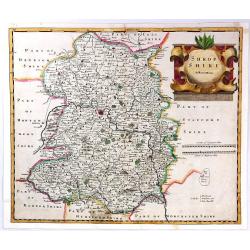
Shropshire By Robert Morden.
A copper engraved hand colored map of Shropshire, England. This map is one of the first country maps to show roads (based on Ogilby's road maps). It includes interesting ...
Date: London, 1695
Selling price: ????
Please login to see price!
Sold in 2018
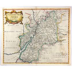
Glocestershire By Robert Morden.
A copper engraved hand colored map of Gloucestershire, England. This map is one of the first country maps to show roads (based on Ogilby's road maps). It includes interes...
Date: London, 1695
Selling price: ????
Please login to see price!
Sold in 2016