Browse Listings
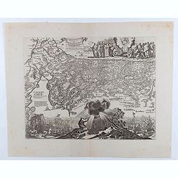
![[Plan of a town]](/uploads/cache/43021-250x250.jpg)
[Plan of a town]
City plan of Satmar in Romania, engraved by Johann Martin Lerch (1659-1684) from Vienna.
Date: Vienna, ca.1686
Selling price: ????
Please login to see price!
Sold in 2019
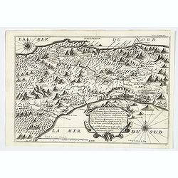
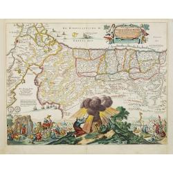
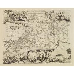
Carte de l'Isthme de Panama. . .
This very attractive map of the Isthmus of Panama was engraved for an early French edition of Alexandre Olivier Exquemelin's History of the Bucaniers of America, an inter...
Date: [Paris], 1686
Selling price: ????
Please login to see price!
Sold in 2019
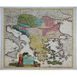
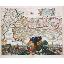
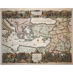
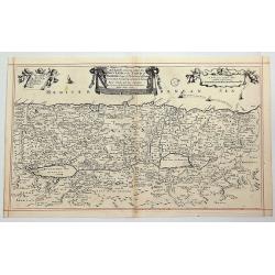
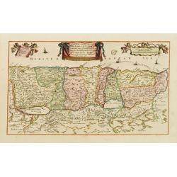
Regni Hungariae, Graeciae et Moreae. . .
A scarce original colored map centred on Greece, extending to all of the Balkans, Hungary, Romania, Aegean Sea and parts of Austria, Italy and Germany of the 17th century...
Date: Amsterdam, before 1686
Selling price: ????
Please login to see price!
Sold in 2019
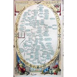
Dialectick or Logick.
An attractive and decorative page. Decorated with symbols and figures. Published in "The Gentleman's Recreation" by Englishman Richard Blome.
Date: London, ca 1686
Selling price: ????
Please login to see price!
Sold in 2019
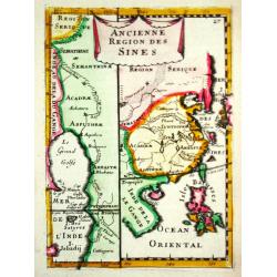
Ancienne Region des Sines.
Alain Manneson Mallet (1603-1706) published in 1683 his ' Description de l' Univers' in 5 volumes. In 1686 a German edition appeared.A map from Alain Manesson Mallet's 'D...
Date: Paris, 1686
Selling price: ????
Please login to see price!
Sold in 2017
Perigrinatie ofte Veertich-jarige Reyse der Kinderen Israels.
Holy Land (Israels Pergrination, or the Forty Years Travels of the Children of Israel out of Egypt through the Red Sea, and the Wilderness into Canaan, or The Land of Pro...
Date: Amsterdam / Dordrecht, H.,J., en M. Doornick 1682-1686
Selling price: ????
Please login to see price!
Sold in 2008
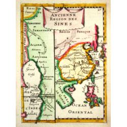
Ancienne Region des Sines.
Alain Manneson Mallet (1603-1706) published in 1683 his ' Description de l' Univers' in 5 volumes. In 1686 a German edition appeared.A map from Alain Manesson Mallet's 'D...
Date: Paris, 1686
Selling price: ????
Please login to see price!
Sold
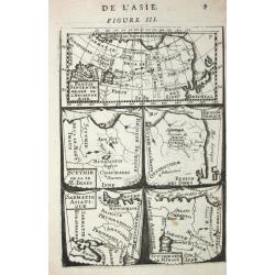
Partie septentrionale de l' Ancienne Asie /Scythie de la M. Imaus / Region Serique / Samatie Asiatique / Scythie deca le M.Imaus.
Alain Manneson Mallet (1603-1706) published in 1683 his ' Description de l' Univers' in 5 volumes. In 1686 a German edition appeared.5 little maps on one sheet
Date: Paris, 1686
Selling price: ????
Please login to see price!
Sold in 2008
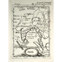
Inde
Alain Manneson Mallet (1603-1706) published in 1683 his ' Description de l' Univers' in 5 volumes. In 1686 a German edition appeared. A map from the German edition of 'De...
Date: Paris, 1686
Selling price: ????
Please login to see price!
Sold
Perigrinatie ofte Veertich-jarige Reyse der Kinderen Israels.
Dutch so-called ' Staten' bibles, published between 1637 and c. 1760, contained five maps: The World, ' Paradise', The Perigrinations, The Promised Land Canaan, The Trave...
Date: Amsterdam / Dordrecht, H.,J., en M. Doornick 1682-1686
Selling price: ????
Please login to see price!
Sold
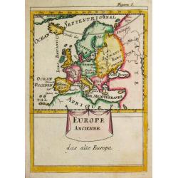
Europe Ancienne.
A map of ancient Europe from the German edition of the "Description de l' Univers".
Date: Paris, 1686
Selling price: ????
Please login to see price!
Sold
De Beschryving van de Reysen Pauli en Van de Andere Apostelen.
Dutch so-called ' Staten' bibles, published between 1637 and c. 1760, contained five maps: The World, ' Paradise', The Perigrinations, The Promised Land Canaan, The Trave...
Date: Amsterdam / Dordrecht, H.,J., en M. Doornick 1682-1686
Selling price: ????
Please login to see price!
Sold
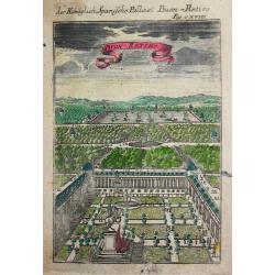
Der Könichlich Spanische Pallast Buon-Retiro.
Alain Manneson Mallet (1603-1706) published in 1683 his ' Description de l' Univers' in 5 volumes. In 1686 a German edition appeared.
Date: Paris, 1686
Selling price: ????
Please login to see price!
Sold
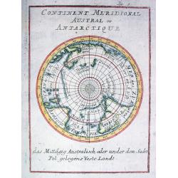
Continent Meridional Austral ou Antarctique
Early map of the southern Hemisphere, showing N. Hollande (Australia), N. Zelande, Terre de Diemens with incomplete coastlines according to the present knowledge. New Gui...
Date: Frankfurt 1686
Selling price: ????
Please login to see price!
Sold

A tutor to Astronomy and Geography. Or an easie and speedy way to know the Use of both the Globes, Celestial and Terestrial. With an appendix shewing the Use of the Ptolemaick Sphere. The fourth edition...
A tutor to Astronomy and Geography. Or an easie and speedy way to know the Use of both the Globes, Celestial and Terestrial. With an appendix shewing the Use of the Ptole...
Date: 4th edition, London, 1686
Selling price: ????
Please login to see price!
Sold
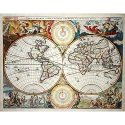
Orbis Terrarum Tabula..
Beautiful double hemisphere world map from a folio Dutch Bible published by Hendrik and Jacob Keur. Surrounded by fabulous scenes from the Visscher-Berchem map of 1658 wi...
Date: Amsterdam 1686
Selling price: ????
Please login to see price!
Sold
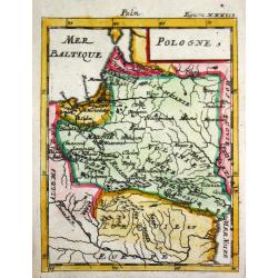
Pologne.
Alain Manneson Mallet (1603-1706) published in 1683 his ' Description de l' Univers' in 5 volumes. In 1686 a German edition appeared.Map of Poland. From the German editio...
Date: Frankfurt, 1686
Selling price: ????
Please login to see price!
Sold

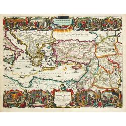
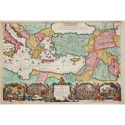
Memoires, historiques & geographiques du Royaume de la Moree, Negrepont, & des places maritimes jusques à Thessalonique. Recueillis & enrichis des cartes des païs & des plas des places.
First French translation and first Dutch edition of Vincenzo Maria Coronelli's (1650-1718) history of Greece, one of the basic source works on the Peloponnesus.On both co...
Date: Amsterdam, Wolfgang, Waesberge, Boom, Van Someren, 1686
Selling price: ????
Please login to see price!
Sold
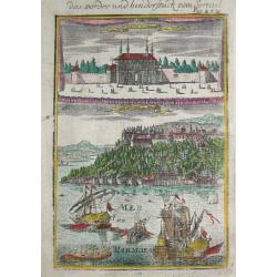
Das vorder und hinderstück vom Serrail.
Alain Manneson Mallet (1603-1706) published in 1683 his ' Description de l' Univers' in 5 volumes. In 1686 a German edition appeared.The serail in Istanbul seen from the ...
Date: Frankfurt, 1686
Selling price: ????
Please login to see price!
Sold
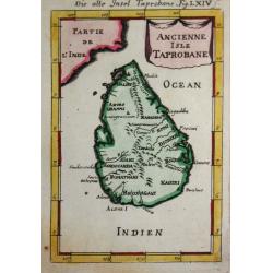
Ancienne Isle Taprobane.
Alain Manneson Mallet (1603-1706) published in 1683 his ' Description de l' Univers' in 5 volumes. In 1686 a German edition appeared.A map from Alain Manesson Mallet's 'D...
Date: Paris, 1686
Selling price: ????
Please login to see price!
Sold in 2017
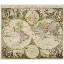
Mappe-Monde Geo-Hydrographique ou Description Generale du Globe Terrestre et Aquatique?
California as an island. According to Shirley, Valck?s Mappe Monde was probably copied from Jaillot?s influential world map of 1674, but in contrast to the plain corners ...
Date: Amsterdam 1686
Selling price: ????
Please login to see price!
Sold
Het Beloofde Landt Canaan door wandelt van onsen Salichmaecker Iesu Christo, neffens syne Apostelen.
Dutch so-called ' Staten' bibles, published between 1637 and c. 1760, contained five maps: The World, ' Paradise', The Perigrinations, The Promised Land Canaan, The Trave...
Date: Amsterdam / Dordrecht, H.,J., en M. Doornick 1682-1686
Selling price: ????
Please login to see price!
Sold
De Beschryving van de Reysen Pauli en Van de Andere Apostelen.
The Dutch so-called ' Staten' bibles published between 1637 and c. 1760, contained 5 maps: The World, ' Paradise', The Perigrinations, The Promised Land Canaan, The Trave...
Date: Dordrecht-Amsterdam, H. Keur en M. Doornik, 1686
Selling price: ????
Please login to see price!
Sold
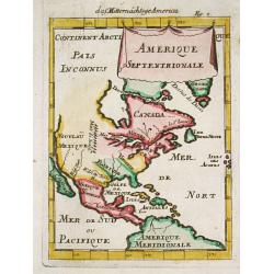
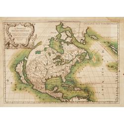
Amerique Septentrionale.
Alain Manneson Mallet (1603-1706) published in 1683 his ' Description de l' Univers' in 5 volumes. In 1686 a German edition appeared.Allain Mallet's attractive little map...
Date: Frankfurt, 1686
Selling price: ????
Please login to see price!
Sold in 2008
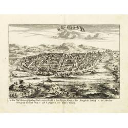
Odia in Siam
Rare panoramic town-view of Bangkok, published in J.C. Wagner "Interiora orientis detecta, oder grundrichtige und eigentl. Bescheibung aller . . . Reiche des Orients...
Date: Augsburg, Koppmayer,1686
Selling price: ????
Please login to see price!
Sold in 2011
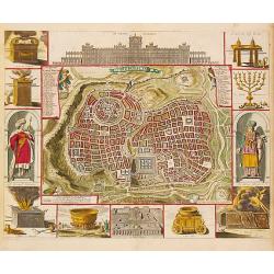
Jerusalem.
Dutch so-called '' Staten'' bibles, published between 1637 and c. 1760, contained 5 maps: The World, '' Paradise'', The Perigrinations, The Promised Land Canaan, The Trav...
Date: Amsterdam / Dordrecht, H. & J. Keur & M. Doornick, 1686
Selling price: ????
Please login to see price!
Sold in 2008
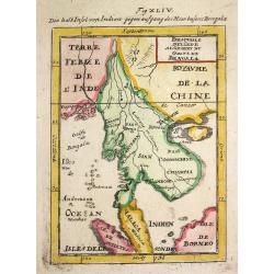
Presqu'isle de l 'lnde a l' Orient de Bengala.
Alain Manneson Mallet (1603-1706) published in 1683 his ' Description de l' Univers' in 5 volumes. In 1686 a German edition appeared.A map from Alain Manesson Mallet's 'D...
Date: Paris, 1686
Selling price: ????
Please login to see price!
Sold in 2008
De Beschryving van de Rysen Pauli..
First state of this richly decorative map of the eastern part of the Mediterranean. The map has vignettes at the top and bottom showing episodes from the book of Acts det...
Date: Amsterdam, 1686
Selling price: ????
Please login to see price!
Sold in 2009
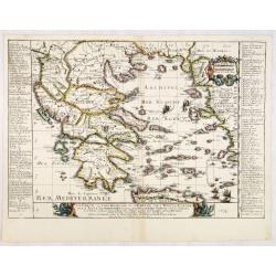
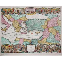
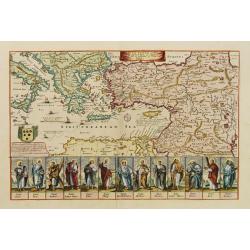
La Grece, ou Partie Meridionale de L'Empire De Turcs en Europe, avec La Table Alphabetique . . .
Uncommon map of the Greek Islands by Pierre Du Val, published in Paris. Shows a number of early sea routes through the islands.
Date: Paris, 1686
Selling price: ????
Please login to see price!
Sold in 2023
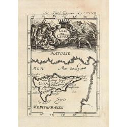
Die Insel Cypern / Isles de Cypre
Decorative engraved map of Cyprus from Alain Manesson Mallet. With a interesting battle scene.
Date: Frankfurt, 1686
Selling price: ????
Please login to see price!
Sold in 2009
Epirus hodie Canina cum Maris Ionii Insulis Corcyra seu Corfu Cephalenia seu Cefalogna etc.
Attractive map of the northwestern coast of Greece and part of present-day Albania. The large allegorical title cartouche features a man with a book representing Wisdom, ...
Date: Wittenberg, 1686
Selling price: ????
Please login to see price!
Sold in 2010
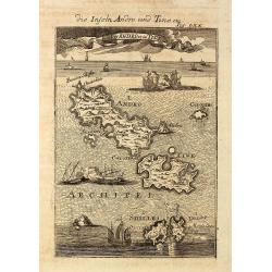
Die Inseln Andro und Tine / I d'Andro et de Tine
Decorative engraved view of the Greek Cyclades Isles Andros and Tinos from Alain Manesson Mallet. With several ship in a sea battle.
Date: Frankfurt, 1686
Selling price: ????
Please login to see price!
Sold in 2010
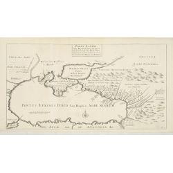
Ponti euxini cum regionibus versus septentrionem et orientem adjacentibus nova tabula.
A rare map of the Black Sea area from the travels of Sir Joan Chardin ( 1643-1713.) into Persia and the East Indies. See Copac . John Chardin (1643-1712) was the son of a...
Date: London, Moses Pitt, 1686
Selling price: ????
Please login to see price!
Sold in 2010
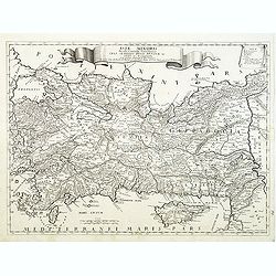
Asia minoris, . . .
Detailed map of Turkey with Cyprus, by Giacomo Cantelli da Vignola (1643-1695). Map Turkey's cities and political divisions as they existed during the Roman Empire.Engrav...
Date: Rome, 1686
Selling price: ????
Please login to see price!
Sold in 2011
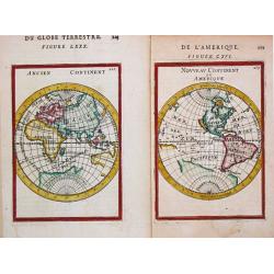
Nouveau Continent ou Amerique. / Ancien Continent
Two separate attractive little maps of the Old and the New World. 'Nouveau Continent ou Amerique. / Ancien Continent.' Alain Manneson Mallet (1603-1706) published in 1683...
Date: Paris, 1683 / Frankfurt, 1686
Selling price: ????
Please login to see price!
Sold in 2020
-250x250.JPG)
Insulae Canariae alias Fortunatae
A 17th century copper-engraved map (nautical chart) of the Canary Islands and Madeira, from a French edition of Olfert Dapper's ´Naukeurige Beschrijvinge der Afrikaensch...
Date: Amsterdam, 1686
Selling price: ????
Please login to see price!
Sold in 2023
Perigrinatie ofte Veertigh-Iarige Reyse der Kinderen Israels, uyt Egypten door de Roode Zee, ende de Woestyne tot in 't Beloofde Landt Canaan.
Beautiful Dutch Bible map of the Holy Land divided into the twelve Tribes of Israel and depicting the Exodus from Egypt and the wanderings of the Children of Israel. The ...
Date: Amsterdam, 1687
Selling price: ????
Please login to see price!
Sold in 2020
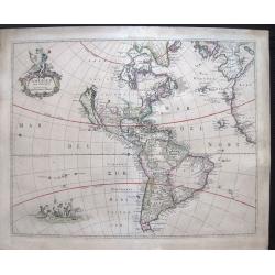
Americae nova discriptio.
A map of America that was never included in an atlas and of which only five other copies are known to exist. The map has original colors although the colors have faded a ...
Date: Amsterdam, 1687
Selling price: ????
Please login to see price!
Sold in 2019
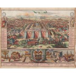
Jerusalem en syn Tempel.
An uncommon, panoramic view depicting the layout of the city surrounding the temple and filled with people, soldiers, livestock and a scene of Judas embracing Jesus and s...
Date: Amsterdam, 1687
Selling price: ????
Please login to see price!
Sold in 2013
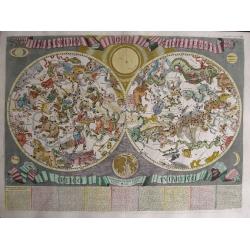
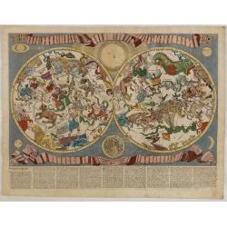
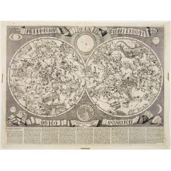
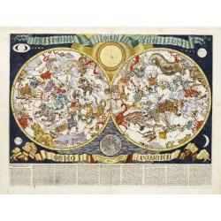
Planisfero del Globo Celeste Artico Antartico. . .
Decorative double hemisphere chart. Text in Italian below image. From Rossi's Mercurio Geografico. Finely engraved by Vin. Mariotti, very decorative double hemisphere c...
Date: Rome, 1687
Selling price: ????
Please login to see price!
Sold in 2014
![Le grand royaume de Hongrie, la Turquie [. . .] Hongrie, la Transilvanie, la Valaqvie, la Moldavie, la Bosnie . . .](/uploads/cache/34669-250x250.jpg)
Le grand royaume de Hongrie, la Turquie [. . .] Hongrie, la Transilvanie, la Valaqvie, la Moldavie, la Bosnie . . .
Rare. Centered on Hungary but covering the present-day region from Prague to Kiev and south to Macedonia. Showing the river Danube in the center of the map.
Date: Paris, 1687
Selling price: ????
Please login to see price!
Sold in 2019
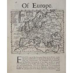
Of Europe.
Rare early English map of Europe, with a list of countries in the upper left key and a with a panel of descriptive text below.
Date: London, 1687
Selling price: ????
Please login to see price!
Sold in 2018
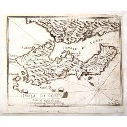
Isola di Corfu.
Little map of the Island of Corfu near Greece by Jan Peeters. From an atlas by Vincenzo Coronelli. It is signed P. Bai. With interesting ribbon title cartouche.
Date: Antwerp, 1687
Selling price: ????
Please login to see price!
Sold in 2015
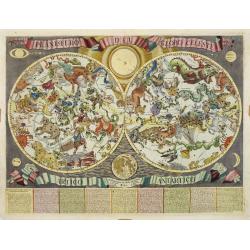
Planisfero del Globo Celeste artico Antartico..
Decorative double hemisphere chart. Text in Italian below image. From Rossi's Mercurio Geografico. Finely engraved by Mariotti, very decorative double hemisphere celestia...
Date: Rome, 1687
Selling price: ????
Please login to see price!
Sold in 2015
Nieuwe lantkarte Van het Noorder en Ooster deel van Asia en Europa strekkende van Nova Zemla to China. . .
Three parts on one sheet. Part from large wall map. Containing a dedication to Peter Aleksejewitsj (later known as czar Peter the Great). Prepared by Nicolas Witsen, Burg...
Date: Amsterdam, 1687
Selling price: ????
Please login to see price!
Sold in 2016
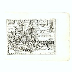
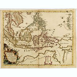
Les Isles des Indes Orientalle.
Rare map of Indonesia, with an oversized Philippines, published by François Jollain (ca. 1641 – 18 April 1704) and included in "Trésor Des Cartes Geographiques D...
Date: Paris, 1687
Selling price: ????
Please login to see price!
Sold in 2018

TAURICA CHERSONESUS. Hodie CRIMEA.
An uncolored very rare copperplate map showing the Crimea peninsula. At the top there's a camel carriage with a tartar.
Date: Nuremberg, 1687
Selling price: ????
Please login to see price!
Sold in 2017
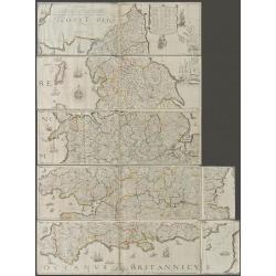
The Travellers Guide being the best Mapp of the Kingdom of England and Principality of Wales. (England & Wales wall map sections).
Fith state of Philip Lea's version of Christopher Saxton's large scale map of England and Wales first published in 1583; this state published Philip Lea, Globe maker at y...
Date: England, 1583 / ca. 1687
Selling price: ????
Please login to see price!
Sold in 2020

Veiie et perspective du Chateau de St, Cloud du Cote de L'Escalier.
An original antique perspective print by Pierre Aveline. In 1685 he obtained royal authority authorising him to reproduce 'Le Profil des Maisons Royales'. Pierre Aveline...
Date: Paris, 1687
Selling price: ????
Please login to see price!
Sold in 2018
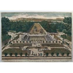
Veiie perspective du Parterre des Cascades et de L'Etang de Fontine - Bleau.
An original antique perspective print by Pierre Aveline. In 1685 he obtained a royal authority authorising him to reproduce 'Le Profil des Maisons Royales'. Pierre Aveli...
Date: Paris, 1687
Selling price: ????
Please login to see price!
Sold in 2018
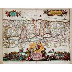
Canaan Commonly Called The Holy Land or The Land of Promise. . .
A fine copperplate map of the Holy land along the Mediterranean Sea, based on the work of Visscher. The track of the Apostle Paul is shown in the Mediterranean Sea. With ...
Date: London, 1687
Selling price: ????
Please login to see price!
Sold in 2023
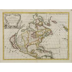
L'America Settentrionale..
Second edition of Rossi's map of North America, based upon Sanson's seminal map, but with revised Italian nomenclature. From Rossi's Mercurio Geographico..Includes a deta...
Date: Rome 1687
Selling price: ????
Please login to see price!
Sold
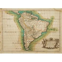
L'America Meridionale..
Second edition of Rossi's map of South America, based upon Sanson's map, but with revised Italian nomenclature. From Rossi's Mercurio Geographico..Engraved by Giorgio Wid...
Date: Rome 1687
Selling price: ????
Please login to see price!
Sold
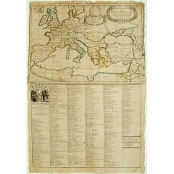
La Carte des Conciles..
From his first edition of his only folio atlas, the map is relied upon the map of his uncle, Nicolas Sanson. Engraved by I.Somer.A nice map of Europe on one sheet, and a ...
Date: Paris, 1687
Selling price: ????
Please login to see price!
Sold
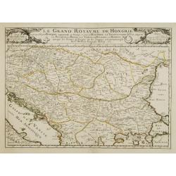
Le grand royaume de Hongrie..
Rare. Showing the countries along the river Donau.
Date: Paris 1687
Selling price: ????
Please login to see price!
Sold
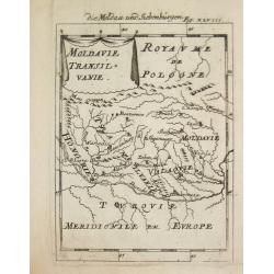
Moldavie Transilvanie.
Alain Manneson Mallet (1603-1706) published in 1683 his ' Description de l' Univers' in 5 volumes. In 1686 a German edition appeared.Map of Rumania. From the German editi...
Date: Paris, 1687
Selling price: ????
Please login to see price!
Sold
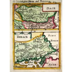
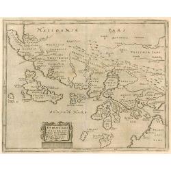
Dace/ Thrace.
Alain Manneson Mallet (1603-1706) published in 1683 his ' Description de l' Univers' in 5 volumes. In 1686 a German edition appeared.Map of the ancient Balkan. From the G...
Date: Paris, 1687
Selling price: ????
Please login to see price!
Sold in 2019
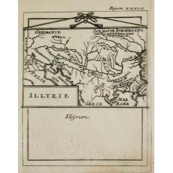
Illyrie.
Alain Manneson Mallet (1603-1706) published in 1683 his ' Description de l' Univers' in 5 volumes. In 1686 a German edition appeared.Map of the ancient Balkan. From the G...
Date: Paris, 1687
Selling price: ????
Please login to see price!
Sold
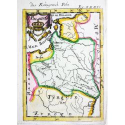
Pologne.
Alain Manneson Mallet (1603-1706) published in 1683 his ' Description de l' Univers' in 5 volumes. In 1686 a German edition appeared.Map of Poland and Lithuania. From the...
Date: Paris, 1687
Selling price: ????
Please login to see price!
Sold in 2010
Planisfero del Globo Celeste artico Antartico..
Decorative double hemisphere chart. Text in Italian below image. From Rossi's Mercurio Geografico. Finely engraved by Mariotti, very decorative double hemisphere celestia...
Date: Rome, 1687
Selling price: ????
Please login to see price!
Sold
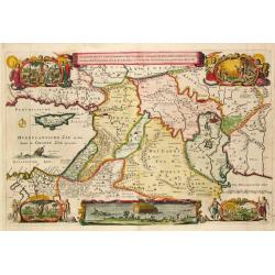
Beschryvinge van den Oorsprong der Volkeren, Uit de drie..
A very decorative map of the region from the Mediterranean through to the Persian Gulf, including Cyprus.The map depicts the Garden of Eden, Abraham's route from Ur, and ...
Date: Amsterdam, 1687
Selling price: ????
Please login to see price!
Sold
Canaan comonly called the Holy Land or the Land of Promise.
The engraver of this map was Richard Palmer.Rare and beautifully engraved map of the ancient land of Canaan which roughly corresponds to present-day Israel. Cherubs hold ...
Date: London, 1687
Selling price: ????
Please login to see price!
Sold in 2012
A mapp of the travels and voyages of the apostles..
The engraver of this map was Richard Palmer.Finely engraved detailed map covering the whole of the eastern Mediterranean. Showing the travels of the apostles after the de...
Date: London 1687
Selling price: ????
Please login to see price!
Sold
Planisfero del Globo Celeste artico Antartico..
Decorative double hemisphere chart. Text in Italian below image. From Rossi's Mercurio Geografico. Finely engraved by Mariotti, very decorative double hemisphere celestia...
Date: Rome 1687
Selling price: ????
Please login to see price!
Sold
Planisfero del Globo Celeste artico Antartico. . .
Decorative double hemisphere chart. Text in Italian below image. From Rossi's Mercurio Geografico. Finely engraved by Mariotti, very decorative double hemisphere celestia...
Date: Rome, 1687
Selling price: ????
Please login to see price!
Sold in 2012
![Le grand royaume de Hongrie, la Turquie [...] Hongrie, la Transilvanie, la Valaqvie, la Moldavie, la Bosnie . . .](/uploads/cache/25589-250x250.jpg)
Le grand royaume de Hongrie, la Turquie [...] Hongrie, la Transilvanie, la Valaqvie, la Moldavie, la Bosnie . . .
Rare. Centered on Hungary but covering the present-day region from Prague to Kiev and south to Macedonia. Showing the river Danube in the center of the map.
Date: Paris, 1687
Selling price: ????
Please login to see price!
Sold in 2008
L'America Settentrionale. Nuovamente Corretta et Accresciuta Secondo le Relationi Piu Moderne da Guglielmo Sansone Geografo ...
Second edition of Rossi's map of North America, based upon Sanson's seminal map, but with revised Italian nomenclature. From Rossi's Mercurio Geographico..Includes a deta...
Date: Rome, 1687
Selling price: ????
Please login to see price!
Sold in 2012
![[continental trade winds map] Bibliotheque universelle et historique, tome 4.](/uploads/cache/91846-250x250.jpg)
[continental trade winds map] Bibliotheque universelle et historique, tome 4.
A book containing Edmund Halley's landmark map -- the first meteorological chart of the world's tropical oceans. His map depicts the oceanic flows, trade wind zones, and ...
Date: Amsterdam, 1687
Selling price: ????
Please login to see price!
Sold in 2016
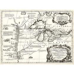
Partie Occidentale du Canada ou de la Nouvelle France...
A very rare map of the Great Lakes by Coronelli / Nolin and one of the most beautiful, acquirable works to focus on the region. As Tooley states, ?it was the best represe...
Date: Paris, 1688
Selling price: ????
Please login to see price!
Sold
Isole dell' India cioe la molucche Le Filippine...
Giacomo Rossi's fine late 17th century map of South East Asia, with nice detail on Philippines. Issued in Il Mercurio geografico In lower left corner a tittle cartouche. ...
Date: Rome, 1683-1688
Selling price: ????
Please login to see price!
Sold in 2017
De Beschryving van de Reysen Pauli en Van de Andere Apostelen.
The Dutch so-called ' Staten' bibles published between 1637 and c. 1760, contained 5 maps: The World, ' Paradise', The Perigrinations, The Promised Land Canaan, The Trave...
Date: Amsterdam, 1688
Selling price: ????
Please login to see price!
Sold in 2008
De Gelegentheyt van t' Paradys en t' Landt Canaan, mitsgaders d' eerst bewoonde Landen der Patriarchen.
Dutch so-called ' Staten' bibles, published between 1637 and c. 1760, contained 5 maps: The World, ' Paradise', The Perigrinations, The Promised Land Canaan, The Travels ...
Date: Amsterdam, Hendrik Keur en Marcus Doornick, 1688
Selling price: ????
Please login to see price!
Sold in 2009
![[ World ]](/uploads/cache/30328-250x250.jpg)
[ World ]
Charming oval wood block map of the world, with a large Southern continent "Circolo Antartico Terra Incognita Australe" by the Italian XVIth and XVIIth century ...
Date: Bologna, Antonio Pisarri, 1594 - 1688
Selling price: ????
Please login to see price!
Sold in 2011
![[British Isles ]](/uploads/cache/30326-250x250.jpg)
[British Isles ]
Charming wood block map of British Isles by the Italian XVIth and XVIIth century writer, humanist and cartographer Giuseppe Rosaccio. Taken from the 1688 Bologna "Te...
Date: Bologna, Antonio Pisarri, 1594 - 1688
Selling price: ????
Please login to see price!
Sold in 2011
![[ World ]](/uploads/cache/30327-250x250.jpg)
[ World ]
Charming wood block map of a world projection, with a large Southern continent "Tera Incognita Australe" by the Italian XVIth and XVIIth century writer, humanis...
Date: Bologna, Antonio Pisarri, 1594 - 1688
Selling price: ????
Please login to see price!
Sold in 2011
![[ Sardigne and Sicily ]](/uploads/cache/30325-250x250.jpg)
[ Sardigne and Sicily ]
Charming wood block map of Sardine and Sicily by the Italian XVIth and XVIIth century writer, humanist and cartographer Giuseppe Rosaccio. Taken from the 1688 Bologna &qu...
Date: Bologna, Antonio Pisarri, 1594 - 1688
Selling price: ????
Please login to see price!
Sold in 2011
![[Central Europe ]](/uploads/cache/30324-250x250.jpg)
[Central Europe ]
Charming wood block map of Central Europe with Prague in the center, Poland, Germany, Switzerland and Austria are also included. Map by the Italian XVIth and XVIIth centu...
Date: Bologna, Antonio Pisarri, 1594 - 1688
Selling price: ????
Please login to see price!
Sold
![[ France ]](/uploads/cache/30322-250x250.jpg)
[ France ]
Charming wood block map of France by the Italian XVIth and XVIIth century writer, humanist and cartographer Giuseppe Rosaccio. Taken from the 1688 Bologna "Teatro de...
Date: Bologna, Antonio Pisarri, 1594 - 1688
Selling price: ????
Please login to see price!
Sold in 2011
![[ Black Sea region, Russia ]](/uploads/cache/30323-250x250.jpg)
[ Black Sea region, Russia ]
Charming wood block map of the Black Sea region, in the north reaching till Moscow by the Italian XVIth and XVIIth century writer, humanist and cartographer Giuseppe Rosa...
Date: Bologna, Antonio Pisarri, 1594 - 1688
Selling price: ????
Please login to see price!
Sold in 2011
![[ Italy and Corsica ]](/uploads/cache/30320-250x250.jpg)
[ Italy and Corsica ]
Charming wood block map of Italy and Corsica by the Italian XVIth and XVIIth century writer, humanist and cartographer Giuseppe Rosaccio. Taken from the 1688 Bologna &quo...
Date: Bologna, Antonio Pisarri, 1594 - 1688
Selling price: ????
Please login to see price!
Sold in 2011