Browse Listings
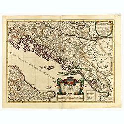
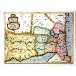
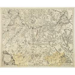
Dalmatia Istria Bosnia Servia Croatia e parte di Schiavonia...
Giacomo Rossi's fine late 17th century map of Dalmatia, with cartouches for the title and dedication. Engraved by Francesco Donia after Vignola. Issued in Il Mercurio geo...
Date: Rome, 1684
Selling price: ????
Please login to see price!
Sold in 2015
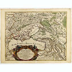
Tartaria D Europa ouero Piccola Tartaria divisa da Giacomo Cantelli da Vignola ne Tartari Nogai e del Crim, o di Precop . . . ne Tartari di Budziack, D'Oczackow, e di Dobrus . . .Tartari Circassi . . .
Engraved by Vin Mariotti. Giacomo Rossi's fine late 17th century map of the Ukraine, Georgia, Muscovy, Southeastern Poland / Lithuania and the Black Sea. Issued in Il Mer...
Date: Rome, 1684
Selling price: ????
Please login to see price!
Sold in 2015
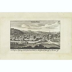
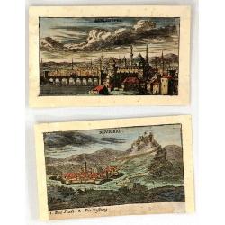
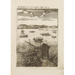
Temeswar. (Timisoara)
View of TimiSoara is a city in the Banat region of western Romania. It is the capital of TimiS County.
Date: Nuremberg, Jacob Sandrart, 1684
Selling price: ????
Please login to see price!
Sold in 2018
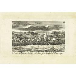
Tokay. (Tokaj)
Panoramic view of Tokaj, the center of the famous Tokaj-Hegyalja wine district where the world-famous Tokaji wine is produced Published in "Der Donau-Strand mit alle...
Date: Nuremberg, Jacob Sandrart, 1684
Selling price: ????
Please login to see price!
Sold in 2015
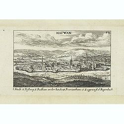
Hatwan.
Panoramic view of Hatvan in Hungary Published in "Der Donau-Strand Mit allen seinen Ein- und Zuflüssen. . .". Published by Jacob Sandrart.
Date: Nuremberg, Jacob Sandrart, 1684
Selling price: ????
Please login to see price!
Sold in 2020
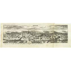
Wardein.
Panoramic view of Grosswardein or NagyváradWardein (Oradea), in northwest Romania near the Hungarian border. Published in "Der Donau-Strand Mit allen seinen Ein- un...
Date: Nuremberg, Jacob Sandrart, 1684
Selling price: ????
Please login to see price!
Sold in 2022
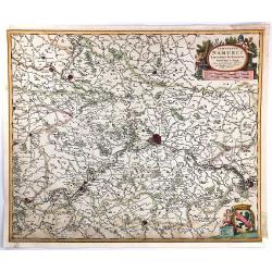
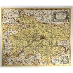
Comitatus Namurci Emendata Delineatio, Nuperrimè in lucem edita, per Nicolaum Visscher.
A detailed engraved map of the Belgian province of Namur (Namen), showing some cities including; Namur, Dinant & Charleroi. From the atlas “Germania Inferior, sive ...
Date: Amsterdam, 1684
Selling price: ????
Please login to see price!
Sold in 2016
Ungaria Orientale. . .
Rossi's map of Hungary, based upon Sanson's map, but with revised Italian nomenclature. The engraver was Francesco Donia.In lower right corner a dedicational cartouche. T...
Date: Rome, 1684
Selling price: ????
Please login to see price!
Sold in 2016
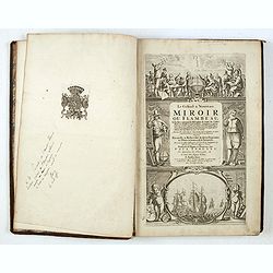
Le Grand & Nouveau Miroir ou Flambeau de la Mer..
A RARE EDITION of a French text edition of this fine Dutch Sea atlas of the West European waters with mostly plates originally engraved by Pieter Goos, who passed into th...
Date: Amsterdam, J. Robijn, 1684
Selling price: ????
Please login to see price!
Sold in 2015
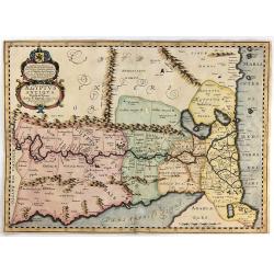
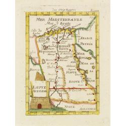
Aegyptus Antiqua Divisa in Nomos.
A map of ancient Egypt that is oriented with West at the top of the page. Sourced from a map by Pierre Duval and published in a Dutch text edition of J. Jansson's histori...
Date: Amsterdam, 1684
Selling price: ????
Please login to see price!
Sold in 2018
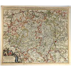
Comitatus Namurci Emendata Delineatio.
A fine copperplate map of the Namur region of Belgium, with the city of Namur at the center. Two large cartouches feature three putti making weapons, wearing armour and s...
Date: Amsterdam, 1684
Selling price: ????
Please login to see price!
Sold in 2016
Luxembergensis Ducatus. Tam in Ejusdem Minores Quam Principales Ditiones Peraccurate Distinctus.
A strikingly decorative map of Luxemburg by Nicholas Visscher II. Taken from the his atlas “Germania Inferior, sive XVII Provinciarum Geographicae generales ut et parti...
Date: Amsterdam, 1684
Selling price: ????
Please login to see price!
Sold in 2016
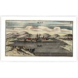
RAB.
Striking and highly decorative unusual miniature copper engraved panoramic view of Raab or Gyor, the Hungarian town on the Danube.Published in "Der Donau-Strand Mit ...
Date: Nuremberg, 1684
Selling price: ????
Please login to see price!
Sold in 2018
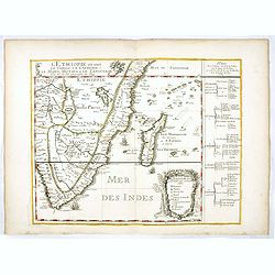
L'Ethiopieoù sont le Congo, La Cafrerie, Le Mono-Montapa et le Zanguebar.
Scarce map of the Southern part of Africa, including Madagascar, etc. Published by Pierre Du Val, who was "geographe de Roy.". Engraved by R. Michault.Part of a...
Date: Paris, 1684
Selling price: ????
Please login to see price!
Sold
Enirne, Turkey & Nograd, Hungary - Two Miniature City Plans
Two miniature copperplate city plans featuring Novigrad, Hungary and Adrianopel, Turkey.They are by Van Birken, published in Germany in 1684.
Date: Germany, 1684
Selling price: ????
Please login to see price!
Sold in 2016
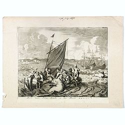
Tocht naer Nova Zemla in den Jaere MDXCVI.
Showing Dutchmen hunting a walrus in Magdalenefjorden (Norway) from a small sailing boat, other walruses at right, two large sailing vessels in the right background, whal...
Date: Amsterdam, 1679-1684
Selling price: ????
Please login to see price!
Sold in 2016
Aegyptus Antiqua Divisa in Nomos
A fine map of ancient Egypt oriented with west at the top of the page. Compiled and drawn by Pierre Duval for Jansson's historical atlas. No text on verso. The map featur...
Date: Amsterdam, 1684
Selling price: ????
Please login to see price!
Sold in 2016
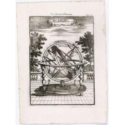
Des Colures - Von denen Coluren.
Appealing print of an armillary sphere.From the German text edition of Description d'Univers.. (5 volumes), 1683. By Allain Manneson Mallet (1630-1706), a well travelled ...
Date: Frankfurt, 1684
Selling price: ????
Please login to see price!
Sold in 2022
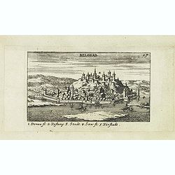
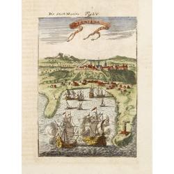
Belgrad.
Panoramic of Belgrade. Belgrade is the capital and largest city of Serbia. The city lies at the confluence of the Sava and Danube rivers, where the Pannonian Plain meets...
Date: Nuremberg, Jacob Sandrart, 1684
Selling price: ????
Please login to see price!
Sold in 2019
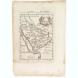
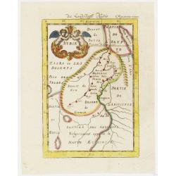
Arabie.
An attractive small map of the Arabian peninsular.
Date: Frankfurt, 1684
Selling price: ????
Please login to see price!
Sold in 2018
![Mexique. [die Stadt Mexica]](/uploads/cache/42156-250x250.jpg)
Mexique. [die Stadt Mexica]
An attractive copper engraving, depicting a bird's-eye view of Mexico City.From the German text edition of Description d'Univers, published in 1684 by Allain Manneson Mal...
Date: Paris, 1684
Selling price: ????
Please login to see price!
Sold in 2018
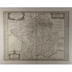
Gallia Vetus ad Julij Caesaris Commentaria.
A striking, detailed, copper engraved map of Gallia or Ancient France at the time of Julius Caesar. It is based on information from Caesar's "De Bello Gallico"....
Date: Amsterdam, 1684
Selling price: ????
Please login to see price!
Sold in 2019
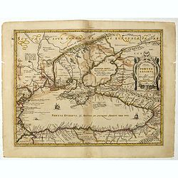
Pontus Euxinus Aequor Iafonio pulfatum remige premum.
Prepared by Ortelius after Mercator, and additional ancient sources as Plinius, Ovidius, Strabo, Apollonius, Procopius and Apianus.This map belongs to a series of histori...
Date: Amsterdam, 1652-1684
Selling price: ????
Please login to see price!
Sold in 2019
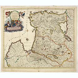
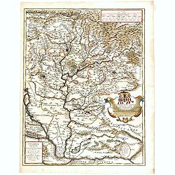
Ducatuum Lovoniae et Curlandiae Novissima Tabula in Quibus sunt Estonia Litlandia et Alir Minorus Provincae Per Iustum Danckerts Amstelodami cum Privilegio Ord: Hollandiae et West-Friesiae.
A rare and decorative map of Estonia, part of Latvia, Lithuania and Russia with a very beautiful cartouche of 2 putti carrying the title and 2 putti supporting 2 coat-of-...
Date: Amsterdam, 1684
Selling price: ????
Please login to see price!
Sold in 2021
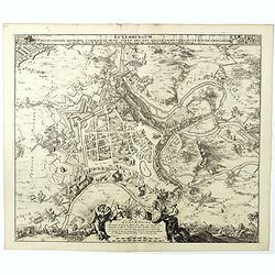
Luxemburgum, Ducat: Cognom: Metropol: á Chimacens: Princ: Stren: Def: Reg: Galliae Armis Vero Occup: IV Iunii Ao. MDCLXXXIIII Luxembourg Ville Capitale . . .
Siege and bombardment of the city of Luxembourg by the French army under the command of Marshal de Créquy, June 4, 1684. Plan of the city and surroundings, in the foregr...
Date: Amsterdam, 1684
Novissima Comitatus Zutphaniae, Totiusque Fluminis Insulae Descriptio, ex Officina Nicolai Visscher.
Map of the province of Gelderland in the Netherlands. Taken from the atlas Germania Inferior, sive XVII Provinciarum Geographicae generales ut et particulares tabulae. Ka...
Date: Amsterdam, 1684
Selling price: ????
Please login to see price!
Sold in 2013
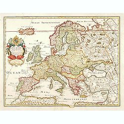
L'Europe? Dediée par sa veuve A Monseigneur Le Dauphin.
"Engraved by Liébaux. Prepared by P. Duval and published by Veuve. RARE."
Date: Paris 1684
Selling price: ????
Please login to see price!
Sold
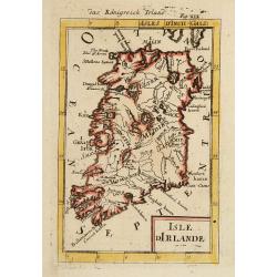
Isle d'Irlande.
A charming late 17th century French map of Ireland, by Allain Manneson Mallet (1630-1706), a well travelled military engineer and geographer who worked in 17th century Fr...
Date: Franckfurt 1684
Selling price: ????
Please login to see price!
Sold
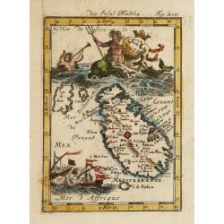
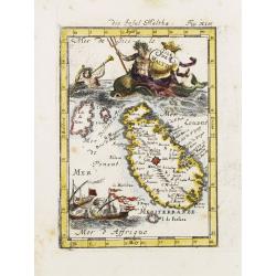
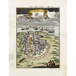
Isle de Malthe.
A charming late 17th century French map of Malta and Gozo with a large pictorial cartouche depicting Neptune and a mermaid, a nautical sailing ship scene across the botto...
Date: Franckfurt 1684
Selling price: ????
Please login to see price!
Sold
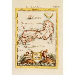
Isles du Japon.
A charming late 17th century French map with a very decorative title cartouche showing trumpet-blowing cherubs.From the German text edition published by Davis Zunners. Je...
Date: Franckfurt 1684
Selling price: ????
Please login to see price!
Sold
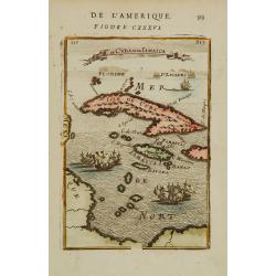
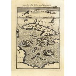
Is. De Cuba et de Jamaica.
A charming late 17th century French map of Cuba and Jamaica.By Allain Manneson Mallet (1630-1706), a well traveled military engineer and geographer who worked in 17th cen...
Date: Franckfurt 1684
Selling price: ????
Please login to see price!
Sold
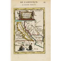
Nouveau Mexique et Californie.
A charming late 17th century French map of California, Nueva Granada and Nouvelle Espagne. California with flat northern coast, labelled Isle de Calfornie. A unique proje...
Date: Franckfurt 1684
Selling price: ????
Please login to see price!
Sold
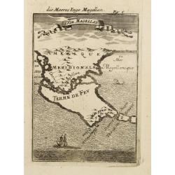
D. de Magellan - die Meeres Enge Magellan.
A map of Tierra del Fuego and Southern Patagonia with bird view. Ships and whales on the ocean. Decorative ribbon with name on the upper part. From the German text editio...
Date: Frankfurt 1684
Selling price: ????
Please login to see price!
Sold
Vaisseaux de l'Asie et de l'Afrique.
Miniature view of various forms of sailing ships from these two continents. From the German text edition of Description d'Univers.. By Allain Manneson Mallet (1630-1706),...
Date: Frankfurt 1684
Selling price: ????
Please login to see price!
Sold
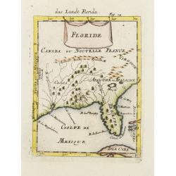
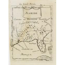
Floride.
A charming late 17th century French map of Florida, Virginia, Louisiana. Tegesta is the name given to the Florida peninsula.The map has little detail, Virginia is above t...
Date: Franckfurt 1684
Selling price: ????
Please login to see price!
Sold
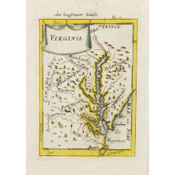
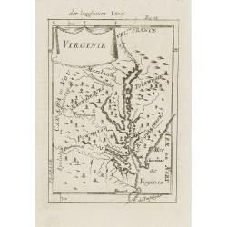
Virginie.
Charming miniature map of the Chesapeake Bay region locating the colony at Jamestown and the village of Pomejok.Several Indian tribes named including Powhatan. Title in c...
Date: Franckfurt 1684
Selling price: ????
Please login to see price!
Sold
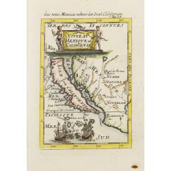
Nouveau Mexique et Californie.
A charming late 17th century French map of California, Nueva Granada and Nouvelle Espagne. California with flat northern coast, labelled Isle de Calfornie. A unique proje...
Date: Franckfurt 1684
Selling price: ????
Please login to see price!
Sold
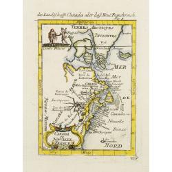
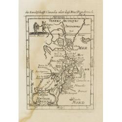
Canada ou Nouvelle France.
A charming late 17th century French map of east coast of Canada and North America.Greenland drawn close to the Canadian coast. The Great Lakes are shown open-ended in the...
Date: Franckfurt 1684
Selling price: ????
Please login to see price!
Sold
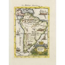
Amerique Meridionale.
A charming late 17th century French map of South America. Decorative cartouche and ships throughout the seas. Several indigenous scenes in the interior of the map showing...
Date: Franckfurt 1684
Selling price: ????
Please login to see price!
Sold
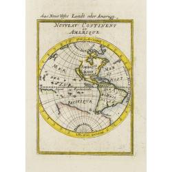
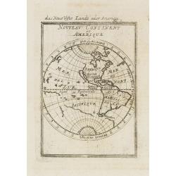
Nouveau continent ou Amerique.
A charming late 17th century French map of the Americas, showing California as an island of Brigg's type, with flat northern coast and no name labeled.The north-western c...
Date: Franckfurt 1684
Selling price: ????
Please login to see price!
Sold
Isle de Malthe.
A charming late 17th century French map of Malta and Gozo with a large pictorial cartouche depicting Neptune and a merman, a nautical sailing ship scene across the bottom...
Date: Franckfurt 1684
Selling price: ????
Please login to see price!
Sold
Malte.
A charming late 17th century French plan of La Valletta. With a ribbon style title cartouche and a nautical sailing ship scene across the top.By Allain Manneson Mallet (1...
Date: Franckfurt 1684
Selling price: ????
Please login to see price!
Sold
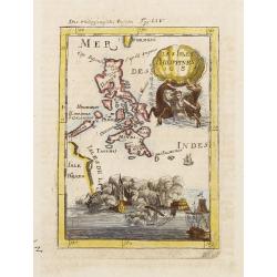
Les Isles Philippines 1684.
A charming late 17th century French map of the Philippines with a large pictorial cartouche depicting a mermaid with sea horses, a nautical sailing ship scene across the ...
Date: Franckfurt 1684
Selling price: ????
Please login to see price!
Sold
Manille.
A charming late 17th century French bird's-eye view of Manila and its harbour. With a ribbon style title cartouche and a nautical sailing ship scene on the bottom.By Alla...
Date: Franckfurt 1684
Selling price: ????
Please login to see price!
Sold
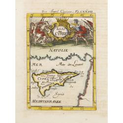
Isles de Cypre.
A charming late 17th century French map of Cyprus with a large pictorial cartouche depicting an infantry combat.By Allain Manneson Mallet (1630-1706), a well traveled mil...
Date: Franckfurt 1684
Selling price: ????
Please login to see price!
Sold
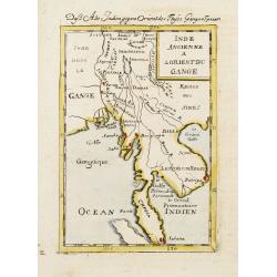
Inde Ancienne A L'Orient Du Gange.
A charming late 17th century French map of the area east of Ganges River, covering Myanmar, Thailand, Cambodia, Laos, Vietnam, part of Malaysia and Sumatra.By Allain Mann...
Date: Franckfurt 1684
Selling price: ????
Please login to see price!
Sold
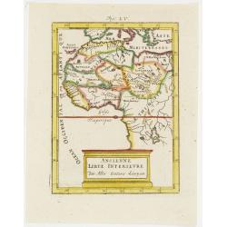
Ancienne Libye Interieure. . .
A charming map of the inland part of Libya with a colorful architectural title cartouche.German title in curtain draped at top. No text on verso.From the German text edit...
Date: Frankfurt, 1684
Selling price: ????
Please login to see price!
Sold in 2012
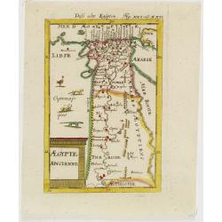
Egypte Ancienne. . .
A charming map of ancient Egypt with a colorful title architectural cartouche.German title in curtain draped at top. No text on verso.From the German text edition publish...
Date: Frankfurt, 1684
Selling price: ????
Please login to see price!
Sold in 2008
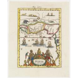
Guinee . . .
A charming map of Guinee with hand painted borderlines and a colorful ornamental title cartouche of two male figures , one holding a parrot, the other a spear that are su...
Date: Frankfurt, 1684
Selling price: ????
Please login to see price!
Sold in 2008
Nubie . . .
A charming map of Nubia which was considered part of the Abyssinian Empire referred to as upper Ethiopia with a colorful title cartouche of two putties holding a burst of...
Date: Frankfurt, 1684
Selling price: ????
Please login to see price!
Sold in 2012
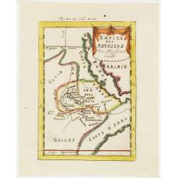
Empire des Abyssins. . .
A charming map of he Abyssinian Empire referred to as Nubia with a colorful title banner.German title in curtain draped at top. No text on verso.From the German text edit...
Date: Frankfurt, 1684
Selling price: ????
Please login to see price!
Sold in 2012
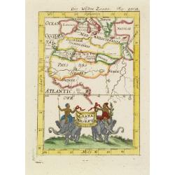
Zaara le Desert . . .
A charming map of the northwestern part of Africa with colored borderlines and a beautiful colorful title banner upheld by two male figures seated on two elephants, one h...
Date: Frankfurt, 1684
Selling price: ????
Please login to see price!
Sold in 2008
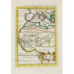
Pays des negres. . .
A charming map of western Africa with colored borderlines and scale in addition to a colorful ornamental title cartouche in lower right corner.German title in curtain dra...
Date: Frankfurt, 1684
Selling price: ????
Please login to see price!
Sold in 2008
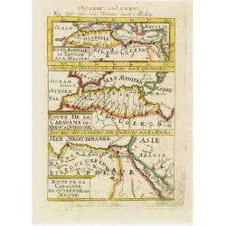
Derr weg der carovane von Maroc nach Mecha et nach Quibriche . .
A charming map of the Route to Mecca from Africa to the Middle East divided into three horizontal detailed route maps with the names of colored towns and coastlines. The ...
Date: Frankfurt, 1684
Selling price: ????
Please login to see price!
Sold in 2008
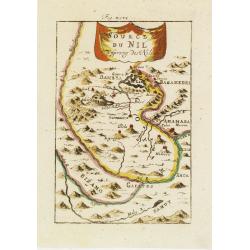
Source du Nil. . .
A charming map of the source of the river Nile. The river are colored along with a colorful title banner.German title in curtain draped at top. No text on verso.From the ...
Date: Frankfurt, 1684
Selling price: ????
Please login to see price!
Sold in 2011
Egypte Moderne. . .
A charming map of Egypt with colored borders and a colorful title cartouche of a stone pyramidal structure in construction.German title in curtain draped at top. No text ...
Date: Frankfurt, 1684
Selling price: ????
Please login to see price!
Sold in 2011
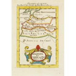
L'Empire du Cherif de Fez Maroc Sud & C. . .
A charming map of Morocco with colored coastlines and a beautiful colorful title cartouche.German title in curtain draped at top. No text on verso.From the German text ed...
Date: Frankfurt, 1684
Selling price: ????
Please login to see price!
Sold in 2008
![I. Goree [Ialoffes Royaume]](/uploads/cache/25317-250x250.jpg)
I. Goree [Ialoffes Royaume]
A charming map featuring a bird's eye view of Island of Goree with hills, dwellings and trees on the island, four ships at sea heading towards the island, and coastal Ara...
Date: Franckfurt, 1684
Selling price: ????
Please login to see price!
Sold in 2008
![Isle de Zocotora [Die Insel Zocotora]](/uploads/cache/25316-250x250.jpg)
Isle de Zocotora [Die Insel Zocotora]
A charming map featuring a bird's eye view of Socotra with hills, dwellings and trees on the island, two naval battles with cannons firing at sea, and coastal Arabia and ...
Date: Frankfurt, 1684
Selling price: ????
Please login to see price!
Sold in 2008
I.de Cuba et de Jamaica.
Map showing the islands of Cuba and Jamaica. The map is inserted in a prospective view of the Caribbean Sea, where some vessels are involved in a naval combat.From the Fr...
Date: Frankfurt, 1684
Selling price: ????
Please login to see price!
Sold in 2013
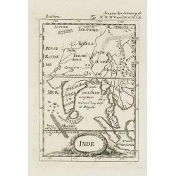
Inde.
A charming late 17th century French map of India, Malay Peninsular with a decorative title cartouche.By Allain Manneson Mallet (1630-1706), a well traveled military engin...
Date: Frankfurt, 1684
Selling price: ????
Please login to see price!
Sold in 2008
Virginie.
Charming miniature map of the Chesapeake Bay region locating the colony at Jamestown and the village of Pomejok.Several Indian tribes named including Powhatan. Title in c...
Date: Frankfurt, 1684
Selling price: ????
Please login to see price!
Sold in 2008
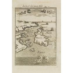
Isle de Terre Neuve.
Charming map centered on the island of Newfoundland, covering also the land around the St. Lawrence Gulf. Embellished with 6 sailing ships and hills in the Labrador area....
Date: Frankfurt, 1684
Selling price: ????
Please login to see price!
Sold in 2008
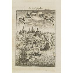
Quebec.
A charming late 17th century French view of Quebec.From the German text edition published by Davis Zunners. Allain Manneson Mallet (1630-1706), a well travelled military ...
Date: Franckfurt, 1684
Selling price: ????
Please login to see price!
Sold in 2008
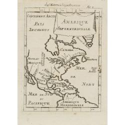
Amerique Septentrionale.
A charming late 17th-century French map of North America, showing California to 40 degrees North and labeled I.Calfornie.From the German text edition published by Davis Z...
Date: Frankfurt, 1684
Selling price: ????
Please login to see price!
Sold in 2008
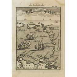
Isles Caribes.
Very handsome map of the Caribbean, extending to include the shores of South America. The map is inserted in a prospective view of the Caribbean Sea, where some vessels a...
Date: Frankfurt, 1684
Selling price: ????
Please login to see price!
Sold in 2008
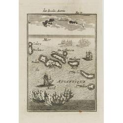
Isles Açores.
Charming map of the Azores islands shown in a perspective view of the Atlantic ocean and embellished with fighting ships just off shores.From the French text edition of D...
Date: Frankfurt, 1684
Selling price: ????
Please login to see price!
Sold in 2008
Canada ou Nouvelle France.
A strange early depiction of the Eastern Seaboard, from Terres Arctiques Incognues to Virginie, including also an outline of the Great Lakes. Native Indians appear at the...
Date: Frankfurt, 1684
Selling price: ????
Please login to see price!
Sold in 2008
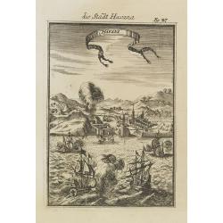
Havana.
Handsome view of the Havana harbour, assaulted by several vessels. Title garland on top.From the French text edition of Description d'Univers, 1683. by Allain Manneson Ma...
Date: Frankfurt, 1684
Selling price: ????
Please login to see price!
Sold in 2008
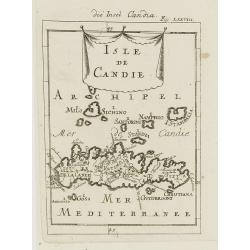
Isle de Candie.
A charming late 17th century French map of Crete and surrounding islands.By Allain Manneson Mallet (1630-1706), a well traveled military engineer and geographer who worke...
Date: Frankfurt, 1684
Selling price: ????
Please login to see price!
Sold in 2009
Floride. / Das Landt Florida.
A charming late 17th century French map of Florida, Virginia, Louisiana. Tegesta is the name given to the Florida peninsula.The map has little detail, Virginia is above t...
Date: Frankfurt, 1684
Selling price: ????
Please login to see price!
Sold in 2008
Nouveau Continent ou Amerique.
Attractive map of the western hemisphere showing the American continent and large part of the Pacific ocean. It outlines the coasts of Australia and Antarctica according ...
Date: Frankfurt, 1684
Selling price: ????
Please login to see price!
Sold in 2008
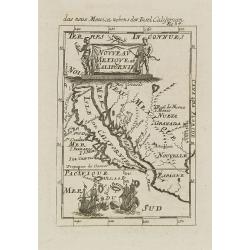
Nouveau Mexique et Californie.
A charming late 17th century French map of California, Nueva Granada and Nouvelle Espagne. California with flat northern coast, labeled Isle de Calfornie. A unique projec...
Date: Frankfurt, 1684
Selling price: ????
Please login to see price!
Sold in 2008
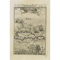
I.d'Hispaniola et Pto Rico.
Map showing the islands of St. Domingo and Puerto Rico. The map is inserted in a prospective view of the Caribbean Sea, where some vessels are involved in a naval combat....
Date: Frankfurt, 1684
Selling price: ????
Please login to see price!
Sold in 2008
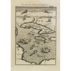
I.de Cuba et de Jamaica.
Map showing the islands of Cuba and Jamaica. The map is inserted in a prospective view of the Caribbean Sea, where some vessels are involved in a naval combat.From the Fr...
Date: Frankfurt, 1684
Selling price: ????
Please login to see price!
Sold in 2008
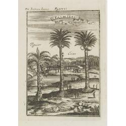
Palmiers.
A fine 17th century depiction of a palm, coconut and a fig tree plantation .From the French text edition of Description d'Univers, 1683. by Allain Manneson Mallet (1630-1...
Date: Frankfurt, 1684
Selling price: ????
Please login to see price!
Sold in 2009
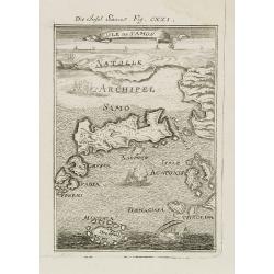
Isle de Samos.
A charming late 17th century map of the Samos Island. Samos is a Greek island in the North Aegean sea, south of Chios, north of Patmos and the Dodecanese, and off the Ion...
Date: Frankfurt, 1684
Selling price: ????
Please login to see price!
Sold in 2010
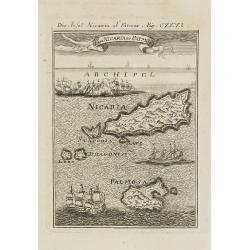
I. de Nicaria et Patmos.
A charming late 17th century map of the Island of Nicaria and Patmos. Located on the eastern borderline of the Aegean Sea, Patmos is the northernmost island of the Dodeca...
Date: Frankfurt, 1684
Selling price: ????
Please login to see price!
Sold in 2011
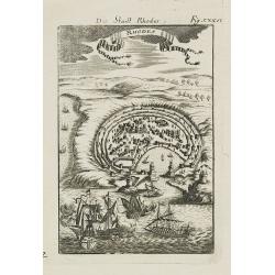
Rhodes.
A charming late 17th century map of the city of Rhodes. By Allain Manneson Mallet (1630-1706), a well traveled military engineer and geographer who worked in 17th century...
Date: Frankfurt, 1684
Selling price: ????
Please login to see price!
Sold in 2008
Isles de Rhodes.
A charming late 17th century map of the Islands of Rhodes. By Allain Manneson Mallet (1630-1706), a well traveled military engineer and geographer who worked in 17th cent...
Date: Frankfurt, 1684
Selling price: ????
Please login to see price!
Sold in 2009