Browse Listings
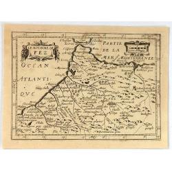
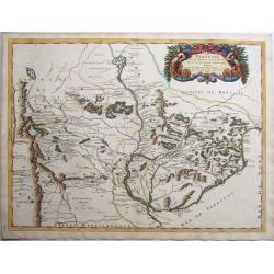
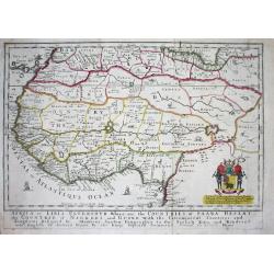
Le Royaume de Fez.
Rare map of a part of Morocco published by Jollain in 1667. Published in "Trésor Des Cartes Geographiques Des Principaux Estats de Lunivers". This atlas is ba...
Date: Paris, 1667
Selling price: ????
Please login to see price!
Sold in 2020
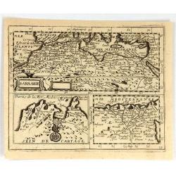
Barbarie.
Rare map of the Barbary Coast of Africa, published by Jollain in 1667. Published in "Trésor Des Cartes Geographiques Des Principaux Estats de Lunivers". This ...
Date: Paris, 1667
Selling price: ????
Please login to see price!
Sold in 2019
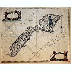
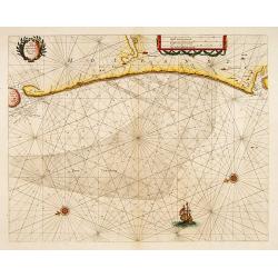
Insula que a Joanne Mayen nomen sortita est.
Splendid and scarce map of Jan Mayen Island. Jan Mayen is an isolated island in the northern Atlantic, lying between 70-72° North and 8-9° West, about 550 kilometers no...
Date: Amsterdam, 1667
Selling price: ????
Please login to see price!
Sold in 2018
![[Genteel Chinese woman.]](/uploads/cache/39528-250x250.jpg)
[Genteel Chinese woman.]
A lovely decorative Chinese print taken from Athanasius Kircher's wonderful work "China Illustrata", published in 1667. It shows a genteel, wealthy Chinese woma...
Date: Amsterdam, 1667
Selling price: ????
Please login to see price!
Sold in 2017
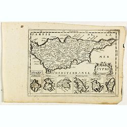
Cypre.
Rare map of Cyprus with decorative title cartouche. Below six small inset maps of Greek islands at bottom of page published by Jollain in 1667. Published in "Trésor...
Date: Paris, 1667
Selling price: ????
Please login to see price!
Sold in 2018
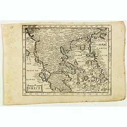
Grece.
Rare map of the Greece, published by Jollain in 1667. Published in "Trésor Des Cartes Geographiques Des Principaux Estats de Lunivers".This atlas is based upon...
Date: Paris, 1667
Selling price: ????
Please login to see price!
Sold in 2021
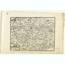
Pologne et Silesie.
Rare map of Poland and Silesia, published by Jollain in 1667. Lower right map number 17.Published in "Trésor Des Cartes Geographiques Des Principaux Estats de Luniv...
Date: Paris, 1667
Selling price: ????
Please login to see price!
Sold in 2023
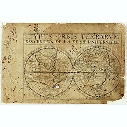
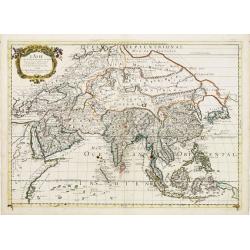
Typus orbis Terrarum description de la Terre universelle.
Rare double hemisphere world map, published by Jollain in 1667. California as an island. Australia connected to the southern continent. Published in "Trésor Des Car...
Date: Paris, 1667
Selling price: ????
Please login to see price!
Sold in 2022
![[Rare double hemisphere celestial chart]](/uploads/cache/41404-250x250.jpg)
[Rare double hemisphere celestial chart]
Rare double hemisphere celestial chart, published by Jollain in 1667. Published in "Trésor Des Cartes Geographiques Des Principaux Estats de Lunivers".This atl...
Date: Paris, 1667
Selling price: ????
Please login to see price!
Sold in 2023
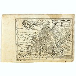
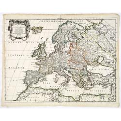
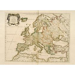
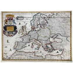
Nouvelle description de l'Europe.
Rare map of Europe with an oversized Iceland, published by Jollain in 1667. Published in "Trésor Des Cartes Geographiques Des Principaux Estats de Lunivers".Th...
Date: Paris, 1667
Selling price: ????
Please login to see price!
Sold in 2019
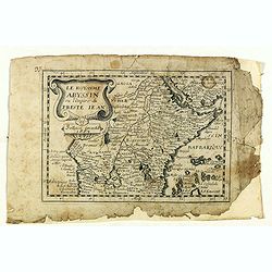
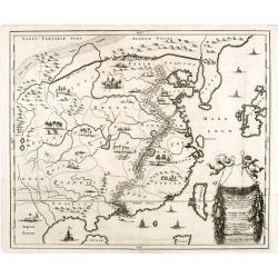
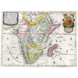
Le Royaume Abyssin ou l'Empire du Presteiean.
Rare map of Central Africa with Ethiopia, published by Jollain in 1667. Published in "Trésor Des Cartes Geographiques Des Principaux Estats de Lunivers".This a...
Date: Paris, 1667
Selling price: ????
Please login to see price!
Sold in 2021
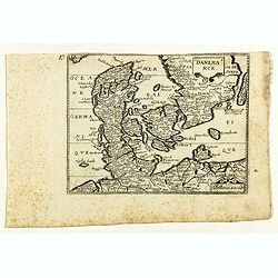
Danemarck.
Rare map of Denmark, published by Jollain in 1667. Published in "Trésor Des Cartes Geographiques Des Principaux Estats de Lunivers".This atlas is based upon Bo...
Date: Paris, 1667
Selling price: ????
Please login to see price!
Sold in 2021
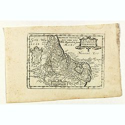
Belgium sive inferior Germania.
Rare map of The Low Countries with present-day The Netherlands, Belgium and Luxemburg, published by Jollain in 1667. Published in "Trésor Des Cartes Geographiques D...
Date: Paris, 1667
Selling price: ????
Please login to see price!
Sold in 2019
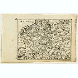
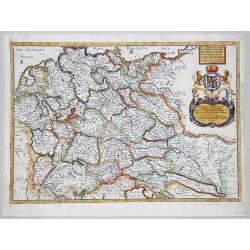
Nouvelle carte D'alemagne corigé.
Rare map of Germany, Poland and Switzerland, published by Jollain in 1667. Published in "Trésor Des Cartes Geographiques Des Principaux Estats de Lunivers".Thi...
Date: Paris, 1667
Selling price: ????
Please login to see price!
Sold in 2019
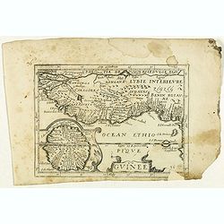
Guinee. (inset) I. S. Thomas.
Rare map of Guinea with inset of I. S. Thomas, published by Jollain in 1667. Published in "Trésor Des Cartes Geographiques Des Principaux Estats de Lunivers".T...
Date: Paris, 1667
Selling price: ????
Please login to see price!
Sold in 2021
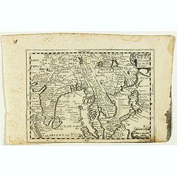
Indes orientales ou Gange.
Rare map of South East Asia, including India, Malaysia, Philippines and Southern China, published by Jollain in 1667. Published in "Trésor Des Cartes Geographiques ...
Date: Paris, 1667
Selling price: ????
Please login to see price!
Sold in 2018
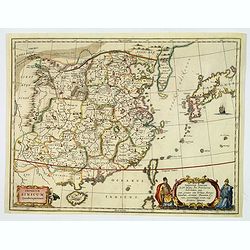
Imperium Sinicum Quindecupartitum.
An attractive, well made map of China, divided in its respective provinces. Formosa and the greater part of Japan are included. At bottom right a finely colored cartouche...
Date: Amsterdam, ca 1667
Selling price: ????
Please login to see price!
Sold in 2019
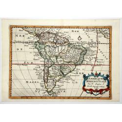
AMERIQUE MERIDIONALE.
A map of South America as prepared by N.Sanson and published by Pierre Mariette. Published in an early edition of the small Sanson atlas 'L'Europe Dediée a Monseigneur ....
Date: Paris, 1667
Selling price: ????
Please login to see price!
Sold in 2020
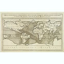
Tabula Geographico-Hydrographica Motus Oceani. . .
The Jesuit scholar Athanasius Kircher was one of the first compilers of semi-scientific knowledge about the physical features of the world. This extraordinary map depicts...
Date: Amsterdam, 1668
Selling price: ????
Please login to see price!
Sold in 2012
![[Title page] Les Plans et Profils des principales Villes et lieux considérables du Comté d'Alost ou Flandre Imperiale. . .](/uploads/cache/33215-250x250.jpg)
[Title page] Les Plans et Profils des principales Villes et lieux considérables du Comté d'Alost ou Flandre Imperiale. . .
Decorative title page from Plans, et Profils des principales villes.. by Ch. De Beaulieu. Etched by mr. Romeijn de Hooghe.
Date: Paris, 1668
Selling price: ????
Please login to see price!
Sold in 2014
Europa Vetus.
Attractive historical map of Europe, the Mediterranean, and northern Africa. Extends to Cyprus and the Holy Land. Based on the cartography of Guillaume Samson and publish...
Date: Paris, 1668
Selling price: ????
Please login to see price!
Sold in 2013
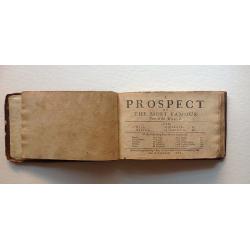
A Prospect of the Most Famous Parts of the World.
John Speed's miniature atlas, published in 1668, 3rd Edition. A rare edition that does not include the maps of British Isles. List of maps include: World map, Asia, Afric...
Date: Roger Rea, London, 1668
Selling price: ????
Please login to see price!
Sold in 2016
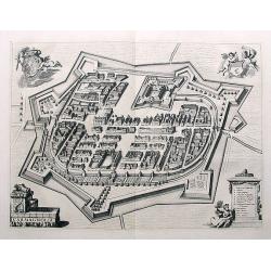
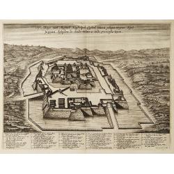
Carmagnolia.
Fantastic town plan of Carmagnolia (Carmagnola) near Turin, published in Theatrum Statuum Regiae Celsitudinis Sabaudiae Ducis, Pedemontii Principis, Cypri Regis from 1668...
Date: Amsterdam, ca. 1668
Selling price: ????
Please login to see price!
Sold in 2018
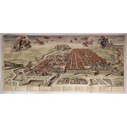
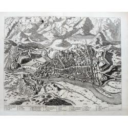
Augustae Tavrinorum Prospectus.
A beautiful, large, very detailed map of Turin (Torino), Italy by Joan Blaeu in Amsterdam in 1668, engraved by Thomas Borgonius. It is from the Atlas “Theatrum Statum R...
Date: Amsterdam, 1668
Selling price: ????
Please login to see price!
Sold in 2017
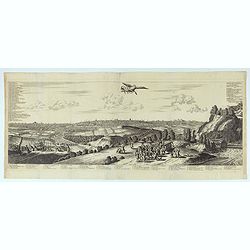
Garexium.
Impressive panoramic view of Garessio in Piemonte, published in Theatrum Statuum Regiae Celsitudinis Sabaudiae Ducis, Pedemontii Principis, Cypri Regis from 1668-1725. T...
Date: Amsterdam, ca. 1668
Selling price: ????
Please login to see price!
Sold in 2017
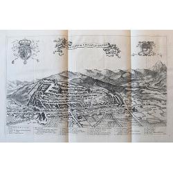
Salutiarum civitas, vulgo Saluzzo.
Large panoramic view showing the city of Saluzzo in Piemonte, published in Theatrum Statuum Regiae Celsitudinis Sabaudiae Ducis, Pedemontii Principis, Cypri Regis from 1...
Date: Amsterdam, ca. 1668
Selling price: ????
Please login to see price!
Sold in 2018

Avillianae Oppidum.
Superb view of Avigliana near Turin. Highly detailed with buildings, fields, a river, the city walls, and the castle above the city. Very decorative with boats on the lak...
Date: Amsterdam, ca. 1668
Selling price: ????
Please login to see price!
Sold in 2018
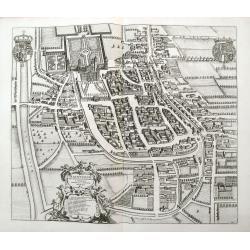
Urbis Vercellensis, à Carolo Emanuele II. . .
An unusual town plan of Vercelli, a city in the Piedmont region in Italy, at the river Sesia. Published in Theatrum Statuum Regiae Celsitudinis Sabaudiae Ducis, Pedemonti...
Date: Amsterdam, ca 1668
Selling price: ????
Please login to see price!
Sold in 2020
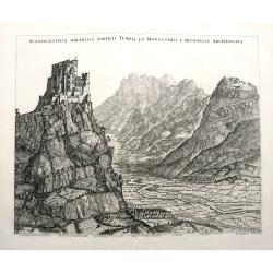
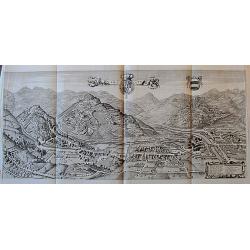
Scenographia Mirabilis Aedificii Templi et Monasterii S. Michaelis Archangeli.
A fantastic view of Sacra di San Michele on top of Monte Pirchiriano, near Turin. Highly detailed with the mountains, the valley with rivers, fields, and towns. A legend ...
Date: Amsterdam, ca. 1668
Selling price: ????
Please login to see price!
Sold in 2018
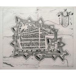
Trino
A fantastic town plan of Trino, a village in the Piedmont region of Italy, between between Turin, Vercelli and Casale Monferrato. It is situated near the River Po. Publis...
Date: Amsterdam, ca 1668
Selling price: ????
Please login to see price!
Sold in 2018
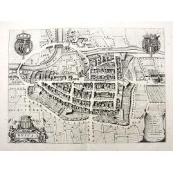
Busca.
Fantastic town plan of Busca near Cuneo, published in Theatrum Statuum Regiae Celsitudinis Sabaudiae Ducis, Pedemontii Principis, Cypri Regis from 1668-1725. Highly det...
Date: Amsterdam, ca. 1668
Selling price: ????
Please login to see price!
Sold in 2018
Raconisium. . .
A fantastic town plan of Racconigi; between Cuneo and Torino, published in Theatrum Statuum Regiae Celsitudinis Sabaudiae Ducis, Pedemontii Principis, Cypri Regis from 16...
Date: Amsterdam, ca 1668
Selling price: ????
Please login to see price!
Sold in 2018
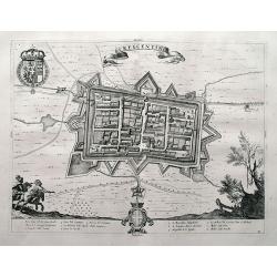
Crescentino.
A superb town plan of Crescentino, a village in the Piedmont region in Italy, between between Turin, Vercelli and Casale Monferrato. It is situated near the River Po. Pub...
Date: Amsterdam, ca 1668
Selling price: ????
Please login to see price!
Sold in 2018

A New Mape of Ye XVII Provinces of Low Germanie.
A detailed miniature map of the Netherlands / Low Countries. From the delightful pocket edition of John Speed's atlas by Van Den Keere, who signs as P. Kaerius.
Date: London, 1668
Selling price: ????
Please login to see price!
Sold in 2018
Gouvernement de Bahus tire de divers Memories.
An attractive map covering modern day Sweden and Norway, with just the northern tip of Jutland also. When this map was published Bahus belonged to Norway, however, it now...
Date: Paris, 1668
Selling price: ????
Please login to see price!
Sold in 2018
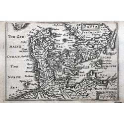
Dania.
A detailed miniature map of Denmark, and the southern part of Sweden. Also parts of northern Germany. From the delightful pocket edition of John Speed's atlas by Van Den ...
Date: London, 1668
Selling price: ????
Please login to see price!
Sold in 2018
Europa Vetus.
A fine map of the ancient European continent.This edition carries the date 1668.Nicolas Sanson was to bring about the rise of French cartography, although the fierce comp...
Date: Paris, 1668
Selling price: ????
Please login to see price!
Sold

(Title page) Les Cartes, Plans et Profils des principales Villes, et Lieux considérables Du Comté de Bourgogne et Païs adjacenta.
Decorative title page from Plans, et Profils des principales villes.. by Ch. De Beaulieu. Etched by mr. Romeijn de Hooghe.
Date: Paris, 1668
Selling price: ????
Please login to see price!
Sold
![Toonneel des Aerdrycx.. [Frontispiece]](/uploads/cache/22983-250x250.jpg)
Toonneel des Aerdrycx.. [Frontispiece]
Frontispiece of the second part of volume one. The title is printed on a separate piece of paper, as is common, and set in an architectural framework flanked by a nun and...
Date: Amsterdam 1668
Selling price: ????
Please login to see price!
Sold
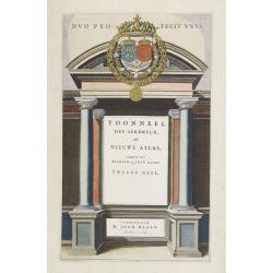
Toonneel des Aerdrycx..
Frontispiece of the second part of this fine atlas. The title is attached on a separate piece of paper, as is common, and set in an architectural framework flanked.At top...
Date: Amsterdam, 1668
Selling price: ????
Please login to see price!
Sold in 2008
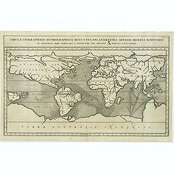
Tabula geographico-hydrographica..
Very unusual world map depicts ocean currents, volcanoes and deep-sea chasms. The continents are void of political detail and only major lakes, rivers and volcanoes are s...
Date: Amsterdam, 1668
Selling price: ????
Please login to see price!
Sold in 2011
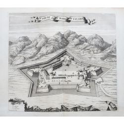
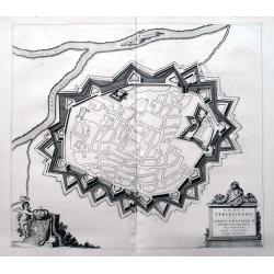
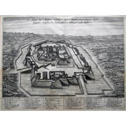
Forte di S.a Maria di Lucerna.
An unusual plan of the forts near Torre Pellice, close to Torino in the Piedmont region in Italy. A beautifully engraved view showing the details of the fortifications wi...
Date: Amsterdam, ca 1668
Selling price: ????
Please login to see price!
Sold in 2020
Ivrea.
A fantastic birds-eye view of the town of Ivrea located on the Dora Baltea river. The town lies to the north of the city of Torino. It is superbly engraved by de Ram, wit...
Date: Amsterdam, ca 1668
Selling price: ????
Please login to see price!
Sold in 2020
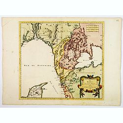
Le Paraguay Tire des Relations les Plus Recentes.
A boldly engraved, rare map of the region of present day Paraguay, Uruguay, northern Argentina, and parts of Chile and Brazil. The Rio de la Plata is the main feature of ...
Date: Paris, 1668
Selling price: ????
Please login to see price!
Sold in 2022
![[Lot of 10 maps / prints of the South Atlantic Ocean islands] CAPEVERDIAN ISLANDS / Insulae Promontorii Viridis.](/uploads/cache/18308-(1)-250x250.jpg)
[Lot of 10 maps / prints of the South Atlantic Ocean islands] CAPEVERDIAN ISLANDS / Insulae Promontorii Viridis.
A map of the Capeverdian islands, embellished with two large and attractive cartouches. With lot of 9 maps / prints of the South Atlantic Ocean islands.
Date: Amsterdam, 1668
Selling price: ????
Please login to see price!
Sold in 2022
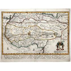
AFRICA or LIBIA ULTERIOUR Where are the COUNTRIES OF SAARA DESERT the COUNTRIE of NEGROES and GUINE.
A map of Western Africa after Sanson. Detailed early geography with numerous errors typical of the time. Important mapping of the Canary Islands. The map shows an unusual...
Date: London, 1669
Selling price: ????
Please login to see price!
Sold in 2019
A MAPP OF EUROPE.
A fine example of Blome's scarce map of Europe, the earliest folio size map of Europe to be engraved and printed in England. The map demonstrates the naïve engraving sty...
Date: London, 1669
Selling price: ????
Please login to see price!
Sold in 2020
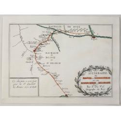
Itineraire de Raguse a Bosna - Serai et de Bosna - Serai a Belgrade.
A map illustrating the route between Belgrade, Serbia and Ragusa on the Adriatic, by way of Bosna-Serai by Sieur Quiclet done during his travels to and from Constantinop...
Date: Paris, 1669
Selling price: ????
Please login to see price!
Sold in 2020
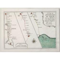
Itineraire de Perse d'Ispaham a Siras de Siras a Lar et de Lar a Gombru. . .
A map illustrating the route in Persia between Ispaham a Siras and Siras a Lar by Sieur Quiclet during his travels to and from Constantinople in 1657 and 1658. Published ...
Date: Paris, 1669
Selling price: ????
Please login to see price!
Sold in 2020
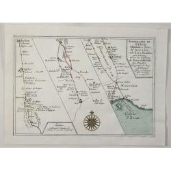
Itineraire de L'Itineraire de Perse. . .
The map reflects Sir Thomas Herbert's travels in the Persian Empire in 1627-1628, as part of a diplomatic Embassy sent by Charles I to Sha Abbas I, in order to establish ...
Date: Paris, 1669
Selling price: ????
Please login to see price!
Sold in 2020
Miako - Kyoto.
A large, rare, copper engraving by Arnoldus Montanus. "Denkwürdige Gesandschaften der Ostindischen Gesellschaft in den vereinigten Niederlanden an unterschiedliche ...
Date: Amsterdm, 1669
Selling price: ????
Please login to see price!
Sold in 2021
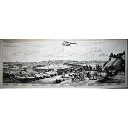
Iedo - Tokyo.
A large, rare, copper engraving by Arnoldus Montanus. "Denkwürdige Gesandschaften der Ostindischen Gesellschaft in den vereinigten Niederlanden an unterschiedliche ...
Date: Amsterdm, 1669
Selling price: ????
Please login to see price!
Sold in 2021

Daibots Gotzenhaus Tempel Van Dajboth Dayboths Temple.
This fascinating 'busy' engraving is that of the inside of a Buddhist temple in Japan depicts a funeral procession for two ambassadors leading up to a somewhat hermaphrod...
Date: Amsterdam, 1669
Selling price: ????
Please login to see price!
Sold in 2021
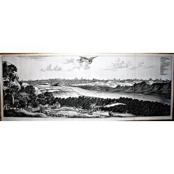
Iedo.
Fine panoramic view of Jedo ( Tokyo) from Joan Nieuhof's comprehensive work about Japan. The view shows fields and landscapes, with the city in the background. With numbe...
Date: Amsterdam, 1669
Selling price: ????
Please login to see price!
Sold in 2023
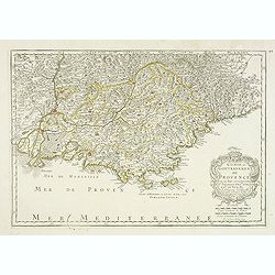
Comte et Gouvernement de Provence, avec les pays. . .
Fine map of the Provence, engraved by R. Cordier d'Abbauil. The cartouche has the date of 1669. Nicolas Sanson was to bring about the rise of French cartography, although...
Date: Paris, 1669
Selling price: ????
Please login to see price!
Sold in 2012
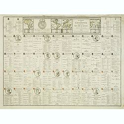
Les Tables de Geographie, reduites en un Jeu de Cartes.
Uncut complete set of Pierre du Val’s rare geographical card game with 52 playing card maps. In top the four continents of America, Africa, Asia and Europe.The last cop...
Date: Paris, 1669
Selling price: ????
Please login to see price!
Sold in 2012
![Sortie des Enfans d'Israel hors d'Egypte. . . [Together 3 maps of Holy Land]](/uploads/cache/33414-250x250.jpg)
Sortie des Enfans d'Israel hors d'Egypte. . . [Together 3 maps of Holy Land]
Map of the Holy Land. At the bottom, Moïse is depicted receiving the Tables of the Law on the Sinai Mount while on both sides are represented the scene of the escape out...
Date: Leiden, 1669
Selling price: ????
Please login to see price!
Sold in 2013
Afbeeldinge vant Maghtich Keyserlyck Casteel Osacca geleegen int groot Ryck Jappan besuyden de Stadt Osacca inde provinsie Qioo
A fantastic bird's-eye plan of the castle at Osaka. With many details and an extensive 35 number key at the bottom.
Date: Amsterdam, 1669
Selling price: ????
Please login to see price!
Sold in 2013
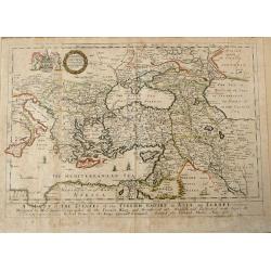
A MAPP of THE ESTATES of the TURKISH EMPIRE in ASIA, and EUROPE.
Uncommon antique map of the Eastern Mediterranean, Italy, Sicily, Cyprus, Turkey, the Black Sea & Caucasus, the Holy Land and Iraq, published in Blome's 'A Geographic...
Date: London, 1669
Selling price: ????
Please login to see price!
Sold in 2014

Kantonis Plana effigies.
Highly detailed view of Guangzhou from the seaside, with numerous ships and buildings illustrated! With "a-p" legend key.
Date: Amsterdam, 1669
Selling price: ????
Please login to see price!
Sold in 2014
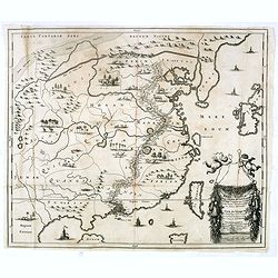
Reys-Kaerte vande Ambassade der Nederlandse Oost Indise Compagnie door China aen den Grooten Tartarsen Cham door Johan Nieuhoff. . .
Fine map of China, Korea, Taiwan (Il.Formosa) from Joan Nieuhof's comprehensive work about China. The map is embellished with sailing ships and junks and a title cartouch...
Date: Amsterdam, 1669
Selling price: ????
Please login to see price!
Sold in 2017
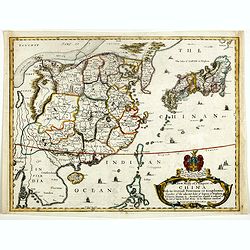
A New Mapp of y Empire of China With its severall Provinces or kingdomes . . .
Richard Blome's scarce early map of China, with coat of arms and dedication to the Honbl. Sr. Thomas Peylon of Knolton in the County of Kent Baronet. Blome's map is close...
Date: London, 1669
Selling price: ????
Please login to see price!
Sold in 2019
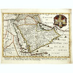
A generall mapp of Arabia, with the Red Sea and circumjacent lands . . .
The earliest folio-sized map of the Arabian Peninsula engraved and published in England.Fine example of this early state of Richard Blome's map of Arabia, distinguishable...
Date: London, 1669
Selling price: ????
Please login to see price!
Sold
A GENERALL MAPP OF THE EMPIRE OF GERMANY with its severall Estates, 1669
A partly colored map of the German Empire. The earliest folio sized map of the region to be engraved in England.Blome's maps, because of their rarity and importance in th...
Date: London, 1669
Selling price: ????
Please login to see price!
Sold in 2020
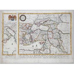
A MAPP of THE ESTATES of the TURKISH EMPIRE in ASIA, and EUROPE, 1669
A rare map of Turkey, Asia Minor, Cyprus, North Africa, Crimea, Southern part of Italy and Eastern Europe . This rare example is the earliest folio sized map of the regio...
Date: London, 1669
Selling price: ????
Please login to see price!
Sold in 2020
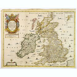
A Generall Mapp of the Isles of Great Britaine. . .
A copperplate border colored map of the British isles with an inset of 'Isles of Schetland', featuring a very decorative cartouche and scale. The earliest folio sized map...
Date: Lonon, 1669
Selling price: ????
Please login to see price!
Sold in 2018
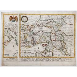
A MAPP of THE ESTATES of the TURKISH EMPIRE in ASIA, and EUROPE, 1669.
A copperplate partly colored map showing Arabie, Asia Minor & Cyprus. This rare example is the earliest folio sized map of the region to be engraved in England by Ric...
Date: London, 1669
Selling price: ????
Please login to see price!
Sold in 2019
Cust van Hollant tusschen de Maes ende Texel.
Uncommon and detailed chart of the coast of Holland, including the southern tip of Texel. East at the top. Two fine compass cards, soundings and a large "Bree Veerth...
Date: Amsterdam 1669
Selling price: ????
Please login to see price!
Sold
De Cust van Hollant Tussen Texel en de Maes. . .
Signed lower right-hand corner: Jacob Colom opt Water Inde Vyerige Colom. Jacob Colom (1600-1673) was a printer, publisher and bookseller in the Fiery Colom in Amsterdam....
Date: Amsterdam, 1669
Selling price: ????
Please login to see price!
Sold in 2020
Afbeeldinge vant Maghtich Keyserlyck Casteel Osacca...
Bird's eye view of the castle of Osaka, from the first description of Japan based on information from the Dutch who served in the V.O.C. (united East-India Company) and f...
Date: Amsterdam 1669
Selling price: ????
Please login to see price!
Sold
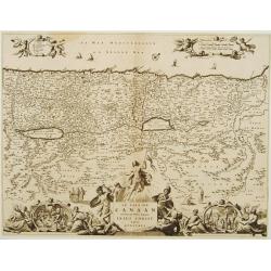
Le Païs de Canaan traversé par notre Seigneur..
Map of the Holy Land. At the bottom, the scene of the Resurrection while on both sides are represented the Nativity and the Crucifixion. Title cartouche upper part held b...
Date: Leiden, 1669
Selling price: ????
Please login to see price!
Sold
Reys-Kaerte vande Ambassade der Nederlandse Oost Indise Compagnie door China aen den Grooten Tartarsen Cham door Johan Nieuhoff. . .
Fine map of China, Korea, Taiwan (Il.Formosa) from Joan Nieuhof's comprehensive work about China. The map shows the track of the Dutch Ambassy of the V.O.C through China....
Date: Amsterdam, 1669
Selling price: ????
Please login to see price!
Sold in 2016
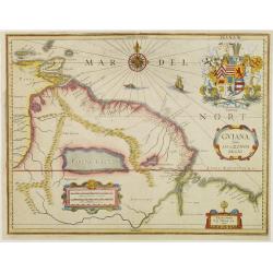
GUIANA sive Amazonum Regio.
Extremely rare map published by J.P. Thelott, extending from the Isla Margarita in the northwest to the coast of northern Brazil near Sao Luis east of the Amazon delta. T...
Date: Franckfurt 1669
Selling price: ????
Please login to see price!
Sold
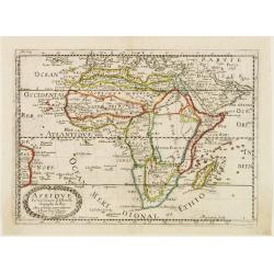
Afrique.
Copper engraved map of Africa that includes Arabia and the Canary and Cape Verde Islands as well as several other Atlantic islands and the coastline of Brazil. Also inclu...
Date: Paris 1669
Selling price: ????
Please login to see price!
Sold
Africa or Libia Ulteriour Where are the Countries of Saara Desert...
Rare map of Western Africa after Sanson. Detailed early Geography with numerous errors of the time. Important mapping of the Canary Islands. The map shows an unusual amou...
Date: London 1669
Selling price: ????
Please login to see price!
Sold
![[Quemoey] On these Islands which are now bècom a Kingdom used the famous Pyrates : Yquon J Kocksinga to Resort.](/uploads/cache/23566-250x250.jpg)
[Quemoey] On these Islands which are now bècom a Kingdom used the famous Pyrates : Yquon J Kocksinga to Resort.
Fine chart of the Taiwanese island group of Quemoy just off Fujian province on mainland China. Taken from Ogilby's translation of Joan Nieuhof's comprehensive work about ...
Date: Amsterdam 1669
Selling price: ????
Please login to see price!
Sold
L'Asie.
Sansons' second map of Asia. North of Japan a peninsula separated from Honshu by the strait of Zungaar (Tsugaru). The discoveries of De Vries are incorporated into this p...
Date: Paris 1669
Selling price: ????
Please login to see price!
Sold
A Mapp of the Higher and Lower Aethiopia Comprehending ye Several Kingdomes ...
The earliest folio sized map of the region to be engraved in England. elaborate heraldic cartouche and a dedication to William Glynne as per Norwich 44. From his Geograph...
Date: London, 1669
Selling price: ????
Please login to see price!
Sold in 2009
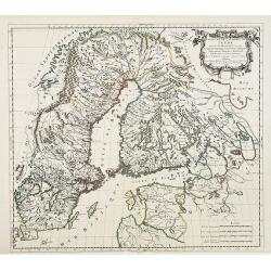
Estats de la couronne de SUEDE dans la Scandinavie..
Map of Sweden and Finland, with original or early outline hand-color. Numerous place-names of counties, cities, towns, physical features.
Date: Paris, 1669
Selling price: ????
Please login to see price!
Sold in 2009
![[Title page of a bible]](/uploads/cache/27973-250x250.jpg)
[Title page of a bible]
This spectacular title page from a bible showing an angel presenting a women with a bible, together with two cherubs, one holding the Ten Commandments and the other with ...
Date: Amsterdam, 1669
Selling price: ????
Please login to see price!
Sold in 2009