Browse Listings
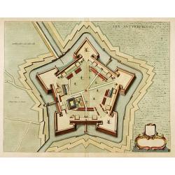
Arx Antverpiensis.
Detailed plan of the Castle and Fort near Antwerp.
Date: Amsterdam, 1666
Selling price: ????
Please login to see price!
Sold in 2022
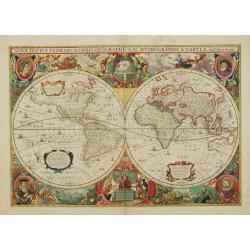
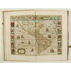
Nova Totius Terrarum Orbis Geographica Ac Hydrographica..
The forth state of Hondius' decorative world map, first issued in the 1630 edition of the Mercator-Hondius Atlas, in response to competition from Willem Blaeu. The basic ...
Date: Amsterdam, dated 1666
Selling price: ????
Please login to see price!
Sold
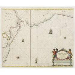
Pascaerte van Nova Hispania Chili Peru en Guatimala..
A scarce chart of southern part of Mexico, Central America, Peru and Chilli. The chart also depicts sailing ships and two compass roses.
Date: Amsterdam 1666
Selling price: ????
Please login to see price!
Sold
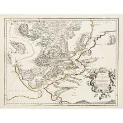
Anaplus Bosphori Thracii..
Detailed map of the Bosporus during ancient time. Lower left Istanbul.
Date: Paris 1666
Selling price: ????
Please login to see price!
Sold
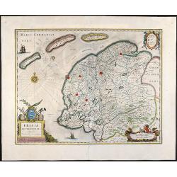
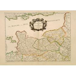
Frisia Occidentalis, Auctoribus Adriano Metio et Gerardo Freitag
Original old colored map of Friesland in northern Holland with 3 beautiful cartouches, two sailing ships and a compass rose. From \"Atlas Contractus\" published...
Date: Amsterdam, 1666
Selling price: ????
Please login to see price!
Sold in 2008
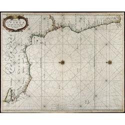
Pas-Caart van Guinea en de Custen daer aen gelegen Van Cabo verde tot Cabo de Bona Esperanca
Beautiful seachart of the southwest coast of Africa by P. Goos from the famous sea atlas "De Zee-Atlas ofte Water-Weereld". Showing the coatlines of Guinea, Sie...
Date: Amsterdam, 1666
Selling price: ????
Please login to see price!
Sold in 2008
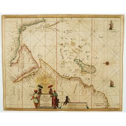
Pascaerte van 't Westelyckste Deel van Oost Indien, van Cabo de Bona Esperanca tot C.Comorin..
An eye-catching of the western part of the Indian Ocean and its adjacent coasts of East Africa, Arabia with the Red Sea and the Arabian Gulf, Iran, Pakistan and western ...
Date: Amsterdam, 1666
Selling price: ????
Please login to see price!
Sold in 2009
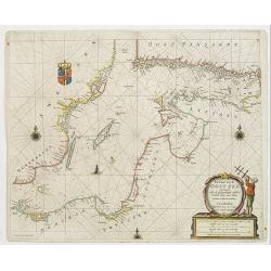
Pas-Caart van de Oost Zee verthooende alle de ghelegenheydt tusschen t Eylandt Rugen ende Wyborg. . .
An eye-catching chart of the Baltic Sea. Engraved by Gerard Coeck.Pieter Goos (ca. 1616-1675) was one of the most important cartographer, engraver, publisher and print se...
Date: Amsterdam, 1666
Selling price: ????
Please login to see price!
Sold in 2009
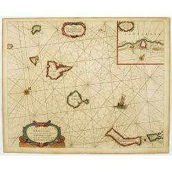
Caarte voor.. Canarise Eylanden als Canaria, Tenerifa..
Very rare chart of the Canaries. Showing Palma, Ferro, Tenerife, Gran Canary, Forte Ventura, Lancelot. In upper right hand corner inset of harbor of Lancerota.Pieter Goos...
Date: Amsterdam, 1666
Selling price: ????
Please login to see price!
Sold in 2017
![Finlande septentr[iona]le et Mérid[iona]le, Nylande, et Tavasthus. . .](/uploads/cache/28355-250x250.jpg)
Finlande septentr[iona]le et Mérid[iona]le, Nylande, et Tavasthus. . .
Map of the southern part of Finland, including Helsinki, Salo, Turku, etc.
Date: Paris, Mariette, 1666
Selling price: ????
Please login to see price!
Sold in 2009
La Carelie, et l'Ingrie, ou Ingermenland. . .
Map of the gulf of Finland and Lake Ladoga and the River Neva. Interesting pre-Saint Petersburg map. The island Retusari, now known as the Kotlin Island is shown. This is...
Date: Paris, P.Mariette, 1666
Selling price: ????
Please login to see price!
Sold in 2009
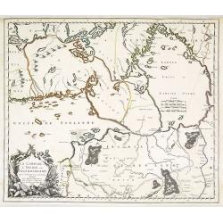
Pascaart van de Witte-Zee begrypende de custen van Laplandt, van Warsiga tot aen Kandalox en de cust van Corelia tot aen de Riviere Dwina.
A decorative chart of the White Sea, embellished with two finely colored title and scale cartouches, 2 ships and 2 compass-roses. With west to the top. In lower right cor...
Date: Amsterdam, 1666
Selling price: ????
Please login to see price!
Sold in 2010
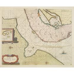
Pascaert van de mont van de Witte Zee tot aende Rivier Dwina al Archan : gel toe.
Three charts on one sheet. A decorative chart of the connection between the White Sea and the Barents Sea, embellished a finely colored title-cartouches, a ship and 2 com...
Date: Amsterdam, 1666
Selling price: ????
Please login to see price!
Sold in 2010
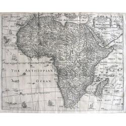
AFRICÆ Descriptio Nova Impensis PHILIPPI CHETWIND 1666
This map is a close copy of John Speed's map of Africa of 1626 with the placenames and text legends in English. The placement of sailing ships, sea monsters, and even muc...
Date: London, (1652) 1666
Selling price: ????
Please login to see price!
Sold in 2011
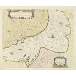
Pascaart van Europa alsmede een gedeelte vande Kust van Africa. . .
An eye-catching chart of the entirety of Europe's coastline from northern Russia to Yugoslavia in the south. Also showing the West Coast of Africa as far as the Cape-Verd...
Date: Amsterdam, after 1666
Selling price: ????
Please login to see price!
Sold in 2011
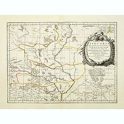
Partie de Lithuanie ou sont en partie les Palatinats de Minsk, et Mseislaw, we les Seign.Ries ou Terres de Rohaczow, Rzeczica, Zernobee, et partie des. . .
Fine map of Lithuania. This edition carries the date 1665 and the publishers address "A Paris, chez l'Autheur". Nicolas Sanson was to bring about the rise of Fr...
Date: Paris, 1666
Selling price: ????
Please login to see price!
Sold in 2011
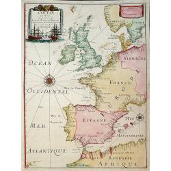
L'Ocean Pres D'Europe Avec Les Costes De France, d'Espagne, de Portugal, d'Angleterre, de Holande, De Danemarc Etc. Suivant Les Costes Marines Les Plus Nouvelles. Par. P. Du Val, Geogr.du Roy. 1666.
Attractive chart by Pierre Du Val shows the North Atlantic Ocean & the coast of Europe from Scandinavia & Great Britain down to France, Spain, the Mediterranean &...
Date: Paris, 1666
Selling price: ????
Please login to see price!
Sold in 2011
Douziéme volume de la Geographie Blavariane.. (America)
In 1662 Joan Blaeu published the most famous of his atlases, the 11-volume Atlas Major in Latin. In the following year editions in French , Dutch , Spanish and German edi...
Date: Amsterdam 1667
Selling price: ????
Please login to see price!
Sold
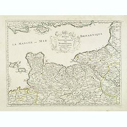
Duche et Gouvernement de Normandie.
Fine map of Normandy.This edition carries the date 1667.Nicolas Sanson was to bring about the rise of French cartography, although the fierce competition of the Dutch wou...
Date: Paris 1667
Selling price: ????
Please login to see price!
Sold
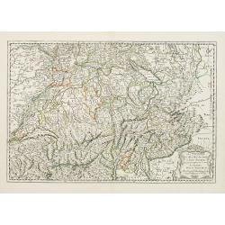
Les Suisses les Allies des Suisses et leurs Suiets..
Fine map of Switzerland. This edition carries the date 1667 and was engraved by R.Cordier Abbauil.Nicolas Sanson was to bring about the rise of French cartography, althou...
Date: Paris, 1648-1667
Selling price: ????
Please login to see price!
Sold in 2009
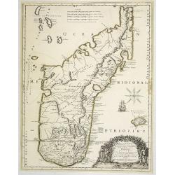
Isle D'Auphine, communement Nommée pae les Europeens Madagascar. . .
Fine map of Madagascar, also showing the Comoros Islands in the North West and the Reunion Island in the South East.With decorative title cartouche representing some nati...
Date: Paris, 1667
Selling price: ????
Please login to see price!
Sold in 2013
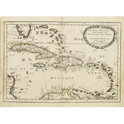
Les Isles Antilles,&c.
Detailed map of the West Indies and Bahamas Islands, with southern most tip of Florida.Published in an early edition of the small Sanson atlas L'Europe Dediée a Monseign...
Date: Paris, P. Marriete, 1667
Selling price: ????
Please login to see price!
Sold in 2008
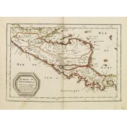
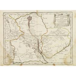
Audience de Guatimala. . .
A finely engraved map of Central America, from the Gulf of Panama and Y. de Perlas to the Southern part of the Yucatan, including the Gulf of Guanajos, the Gulf of Hondur...
Date: Paris, P. Marriete, 1667
Selling price: ????
Please login to see price!
Sold in 2011
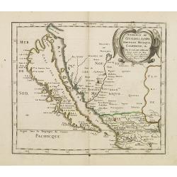
Audience de Guadalajara nouveau Mexique, Californie. &c.
A finely engraved map of California and New Mexico. Prior to this map, all maps with California shown as an Island were either World maps, Western Hemisphere, North Ameri...
Date: Paris, P. Marriete, 1667
Selling price: ????
Please login to see price!
Sold in 2016
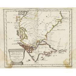
Destroit de Magellan, Terre et Isles Magellanicques . . .
Map of the Teierra del Fuego, Magellan Detroit prepared by N.Sanson and published by Pierre Mariette.Published in an early edition of the small Sanson atlas L'Europe Dedi...
Date: Paris, P. Mariette, 1667
Selling price: ????
Please login to see price!
Sold in 2008
Le Paraguay . . .
Map of Paraguay prepared by N.Sanson and published by Pierre Mariette.Published in an early edition of the small Sanson atlas L'Europe Dediée a Monseigneur . . . Le Tell...
Date: Paris, P. Mariette, 1667
Selling price: ????
Please login to see price!
Sold in 2011
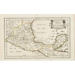
Audience de Mexico . . .
Map of Mexico prepared by N.Sanson and published by Pierre Mariette.Published in an early edition of the small Sanson atlas L'Europe Dediée a Monseigneur . . . Le Tellie...
Date: Paris, P. Mariette, 1667
Selling price: ????
Please login to see price!
Sold in 2010
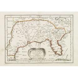
La Floride . . .
Map of Florida prepared by N.Sanson and published by Pierre Mariette.Published in an early edition of the small Sanson atlas L'Europe Dediée a Monseigneur . . . Le Telli...
Date: Paris, P. Mariette, 1667
Selling price: ????
Please login to see price!
Sold in 2008
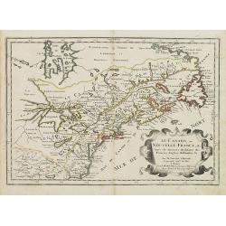
Le Canada ou Nouvelle France &c. Tirée de diverses Relations des Francois, Anglois, Hollandois &c.
Map of Canada and the Great Lakes, which would influence the cartography of the region for the next 100 years. Along with Sanson's Folio map, this map includes many first...
Date: Paris, P. Mariette, 1667
Selling price: ????
Please login to see price!
Sold in 2008
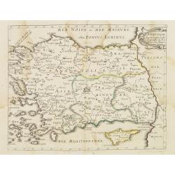
Mer Noire ou Mer Maievre . . .
Map encompassing part of the Near East and the area comprehended between the Black Sea and the Caspian Sea. Centered on Turkey and Cyprus prepared by N.Sanson and publish...
Date: Paris, P. Mariette, 1667
Selling price: ????
Please login to see price!
Sold in 2011
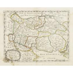
L'Empire du Sophy des Perses. . .
Map of Persian Empire prepared by N.Sanson and published by Pierre Mariette.Published in an early edition of the small Sanson atlas L'Europe Dediée a Monseigneur . . . L...
Date: Paris, P. Mariette, 1667
Selling price: ????
Please login to see price!
Sold in 2011
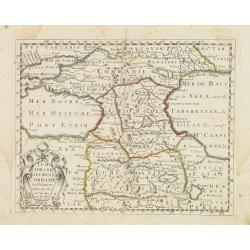
Turcomanie Georgie Commanie. . .
Attractive general map of Caucasus Mountains, Armenia and Georgia prepared by N.Sanson and published by Pierre Mariette.Published in an early edition of the small Sanson ...
Date: Paris, P. Mariette, 1667
Selling price: ????
Please login to see price!
Sold in 2008
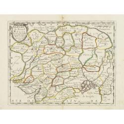
L'Empire du Grand Mongol. . .
Map of the Northern part of India and the Mongol Empire prepared by N.Sanson and published by Pierre Mariette.Published in an early edition of the small Sanson atlas L'Eu...
Date: Paris, P. Mariette, 1667
Selling price: ????
Please login to see price!
Sold in 2008
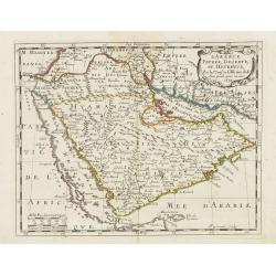
L'Arabie Petrée, Deserte, et hevrevse. . .
Attractive map of the Arabian peninsula prepared by N.Sanson and published by Pierre Mariette.Published in an early edition of the small Sanson atlas L'Europe Dediée a M...
Date: Paris, P. Mariette, 1667
Selling price: ????
Please login to see price!
Sold in 2008
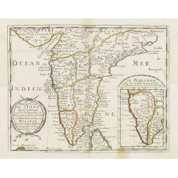
Presqu'isle de l'Inde. . .
Map of the Indian peninsula prepared by N.Sanson and published by Pierre Mariette.Published in an early edition of the small Sanson atlas L'Europe Dediée a Monseigneur ....
Date: Paris, P. Mariette, 1667
Selling price: ????
Please login to see price!
Sold in 2008
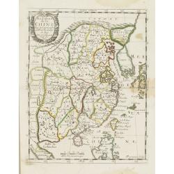
Royaume de la Chine. . .
Map of China including the current island of Taiwan prepared by N.Sanson and published by Pierre Mariette. Korea shown as an insular.Published in an early edition of the ...
Date: Paris, P. Mariette, 1667
Selling price: ????
Please login to see price!
Sold in 2008
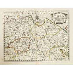
La Grande Tartarie. . .
Map of Tartary which incorporates the current areas of Siberia, Turkestan (including East Turkestan), Greater Mongolia, Manchuria prepared by N.Sanson and published by Pi...
Date: Paris, P. Mariette, 1667
Selling price: ????
Please login to see price!
Sold in 2009
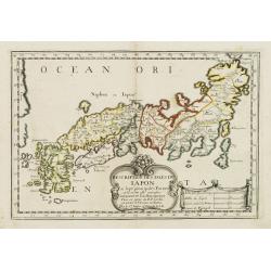
Description des Isles du Iapon. . .
Map of Japan prepared by N.Sanson and published by Pierre Mariette.Published in an early edition of the small Sanson atlas L'Europe Dediée a Monseigneur . . . Le Tellier...
Date: Paris, P. Mariette, 1667
Selling price: ????
Please login to see price!
Sold in 2008
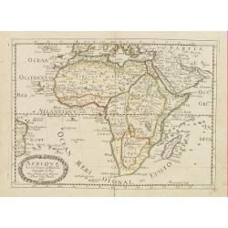
Afrique. . .
Map of the African continent prepared by N.Sanson and published by Pierre Mariette.Published in an early edition of the small Sanson atlas L'Europe Dediée a Monseigneur ...
Date: Paris, P. Mariette, 1667
Selling price: ????
Please login to see price!
Sold in 2008

Les Iles Philippines. . .
Map of the Philippine Islands prepared by N.Sanson and published by Pierre Mariette.Published in an early edition of the small Sanson atlas L'Europe Dediée a M...
Date: Paris, P. Mariette, 1667
Selling price: ????
Please login to see price!
Sold in 2009
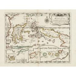
Les Iles Molvcques, Celebes, Gilolo. . .
Map of the Indian Ocean Islands of the Moluccas Islands prepared by N.Sanson and published by Pierre Mariette.Published in an early edition of the small Sanson atlas L'Eu...
Date: Paris, P. Mariette, 1667
Selling price: ????
Please login to see price!
Sold in 2009
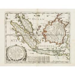
Les Isles de la Sonde entre lelquelles font Sumatra, Iava, Borneo. . .
Map of the islands of Java, Sumatra, Borneo and Bali. prepared by N.Sanson and published by Pierre Mariette.Published in an early edition of the small Sanson atlas L'Euro...
Date: Paris, P. Mariette, 1667
Selling price: ????
Please login to see price!
Sold in 2013
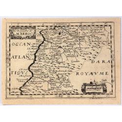
Royaume de Maroc. . .
Map of Morocco prepared by N.Sanson and published by Pierre Mariette.Published in an early edition of the small Sanson atlas L'Europe Dediée a Monseigneur . . . Le Telli...
Date: Paris, P. Mariette, 1667
Selling price: ????
Please login to see price!
Sold in 2012
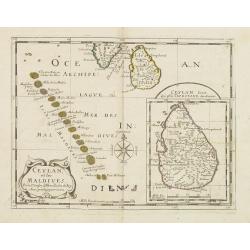
Ceylan et les Maldives. . .
A fine map of Shri Lanka, and the Maldives prepared by N.Sanson and published by Pierre Mariette.Published in an early edition of the small Sanson atlas L'Europe Dediée ...
Date: Paris, P. Mariette, 1667
Selling price: ????
Please login to see price!
Sold in 2008
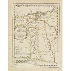
Egypte divisée en ses douze cassilifs, ou gouvermens. . .
Map of Egypt prepared by N.Sanson and published by Pierre Mariette.Published in an early edition of the small Sanson atlas L'Europe Dediée a Monseigneur . . . Le Tellier...
Date: Paris, P. Mariette, 1667
Selling price: ????
Please login to see price!
Sold in 2013
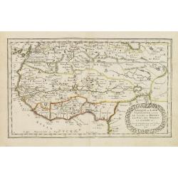
L'Afrique ou Libie ulterieur ou font le Saara ou desert. . .
Map of Guinea coast prepared by N.Sanson and published by Pierre Mariette.Published in an early edition of the small Sanson atlas L'Europe Dediée a Monseigneur . . . Le ...
Date: Paris, P. Mariette, 1667
Selling price: ????
Please login to see price!
Sold in 2008
Partie de la Haute Aethiopie. . .
Map of Ethiopia prepared by N.Sanson and published by Pierre Mariette.Published in an early edition of the small Sanson atlas L'Europe Dediée a Monseigneur . . . Le Tell...
Date: Paris, P. Mariette, 1667
Selling price: ????
Please login to see price!
Sold in 2008
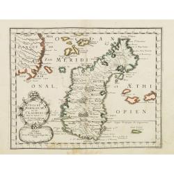
Isle de Madagascar. . .
Map of Madagascar prepared by N.Sanson and published by Pierre Mariette.Published in an early edition of the small Sanson atlas L'Europe Dediée a Monseigneur . . . Le Te...
Date: Paris, P. Mariette, 1667
Selling price: ????
Please login to see price!
Sold in 2008
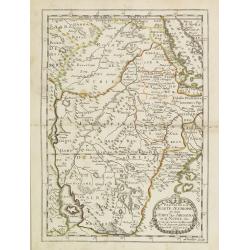
Pays et Coste des Caferes: Empres du Monomotapa Monoemugi. . .
Map of Southern Africa prepared by N.Sanson and published by Pierre Mariette.Published in an early edition of the small Sanson atlas L'Europe Dediée a Monseigneur . . . ...
Date: Paris, P. Mariette, 1667
Selling price: ????
Please login to see price!
Sold in 2008
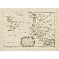
Isle du Cap Verd Coste, et pays des Negres. . .
Depicting the West Coast of North Africa and also showing the Cape Verde Islands prepared by N.Sanson and published by Pierre Mariette.Published in an early edition of th...
Date: Paris, P. Mariette, 1667
Selling price: ????
Please login to see price!
Sold in 2008
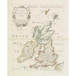
Isles Britaniques. . .
Map of Great Britain prepared by N.Sanson and published by Pierre Mariette.Published in an early edition of the small Sanson atlas L'Europe Dediée a Monseigneur . . . Le...
Date: Paris, P. Mariette, 1667
Selling price: ????
Please login to see price!
Sold in 2013
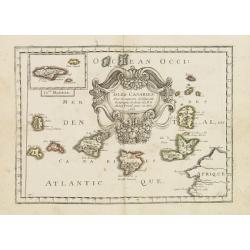
Isles Canaries. . .
Map of Canary Islands prepared by N.Sanson and published by Pierre Mariette.Published in an early edition of the small Sanson atlas L'Europe Dediée a Monseigneur . . . L...
Date: Paris, P. Mariette, 1667
Selling price: ????
Please login to see price!
Sold in 2011
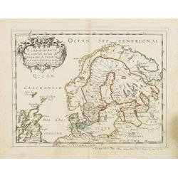
Scandinavie ou sont les Estats de Danemark, de Suede & C. . .
Map of Scandinavia prepared by N.Sanson and published by Pierre Mariette. Some contemporary manuscript annotations in brown ink. Published in an early edition of the smal...
Date: Paris, P. Mariette, 1667
Selling price: ????
Please login to see price!
Sold in 2012
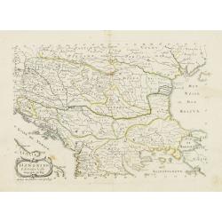
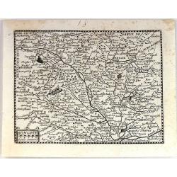
Hongrie & . . .
Map of Hungary prepared by N.Sanson and published by Pierre Mariette.Published in an early edition of the small Sanson atlas L\'Europe Dediée a Monseigneur . . . Le Tell...
Date: Paris, P. Mariette, 1667
Selling price: ????
Please login to see price!
Sold in 2009
Estats de la Couronne de Pologne.
Map of Poland prepared by N.Sanson and published by Pierre Mariette.Published in an early edition of the small Sanson atlas L'Europe Dediée a Monseigneur . . . Le Tellie...
Date: Paris, P. Mariette, 1667
Selling price: ????
Please login to see price!
Sold in 2008
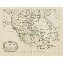
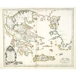
Partie de Turquie. . .
Map of Greece, the Aegean Sea and European part of Turkey prepared by N.Sanson and published by Pierre Mariette.Published in an early edition of the small Sanson atlas L\...
Date: Paris, P. Mariette, 1667
Selling price: ????
Please login to see price!
Sold in 2009
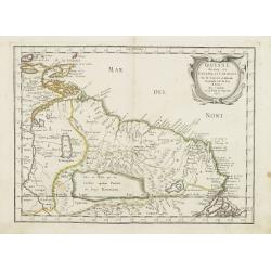
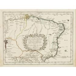
Guiane divisee en Guiane, et Caribane. . .
Map of Guinea prepared by N.Sanson and published by Pierre Mariette. This is a reduced derivative of the famous Sanson map of 1650.Published in an early edition of the sm...
Date: Paris, P. Mariette, 1667
Selling price: ????
Please login to see price!
Sold in 2008
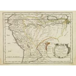
Le Perou et le cours de la Riviere Amazone. . .
Standard map of Peru and the River Amazon prepared by N.Sanson and published by Pierre Mariette.Published in an early edition of the small Sanson atlas L'Europe Dediée a...
Date: Paris, P. Mariette, 1667
Selling price: ????
Please login to see price!
Sold in 2009
Le Bresil don't la coste est. . .
Map of Brazil. Published in an early edition of the small Sanson atlas L'Europe Dediée a Monseigneur . . . Le Tellier Secret. D'Estat &c."The ...
Date: Paris, P. Mariette, 1667
Selling price: ????
Please login to see price!
Sold in 2009
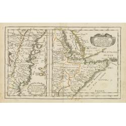
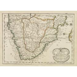
Le Zanguebar Partie du Zanguebar ou sont les Costes d'AJAN et d'ABEX.
Two maps on one sheet showing the coasts of East Africa. The left hand map shows the Zanzibar coast, the right hand map shows the coast north from Zanzibar, round the Hor...
Date: Paris, P. Mariette, 1667
Selling price: ????
Please login to see price!
Sold in 2008
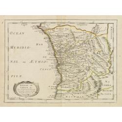
Royaume de Congo & c. . .
Decorative map of the Congo on Africa's west coast.An attractive miniature map prepared by N.Sanson and published by Pierre Mariette.Published in an early edition of the ...
Date: Paris, P. Mariette, 1667
Selling price: ????
Please login to see price!
Sold
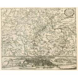
Tabula Geographica Archi-Dioecesis Trevirensis Antiquo-nova 1667.
Rare map of the region of Trier. Inset map with panorama of Trier.
Date: 1667
Selling price: ????
Please login to see price!
Sold in 2010
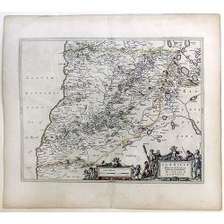
Carricta Meridionalis, The South part of Carrick.
Map of the south part of Carrick, a district in Scotland, outlined in colorful ribbons. Smaller town are shown within the region, many noticeably long the rivers that int...
Date: Amsterdam, c. 1667
Selling price: ????
Please login to see price!
Sold in 2010
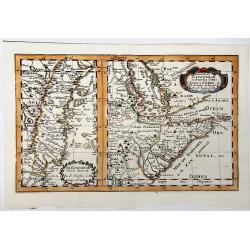
Partie du ZANGUEBAR ou Sont les Costes d'AJAN et d' ABEX &c.
Two, maps on one sheet showing the coasts of East Africa. The left hand map shows the Zanzibar coast, the right hand map shows the coast north from Zanzibar, round the Ho...
Date: Paris, P. Mariette, 1667
Selling price: ????
Please login to see price!
Sold in 2019
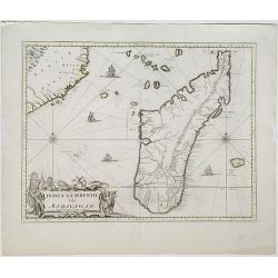
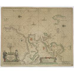
Insula S. Laurentii, vulgo Madagascar.
Map of the island of Madagascar and coastline of Mozambique. Title and impressum in a nice cartouche with figures and animals at bottom left. Shows also the islands arou...
Date: Amsterdam, 1667
Selling price: ????
Please login to see price!
Sold in 2022
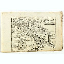
Italie Corse Sardaigne et Province adiacentes.
Rare map of general Italy, published by Jollain in 1667. Published in "Trésor Des Cartes Geographiques Des Principaux Estats de Lunivers".This atlas is based u...
Date: Paris, 1667
Selling price: ????
Please login to see price!
Sold in 2022
Duche et gouvernement de Normandie.
Fine map of Normandy, with the islands of Jersey and Guernsey. Engraved by R. Cordier d'Abbauil. This edition carries the date 1667. Nicolas Sanson was to bring about the...
Date: Paris, 1667
Selling price: ????
Please login to see price!
Sold
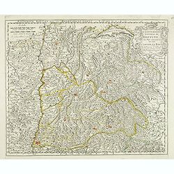
Le gouvernement general du Daufine, et.. La Savoye. . .
Fine map of south eastern part of France and part of Switzerland. Centered on Basle and the Alps.This edition carries the date 1667. Engraved by R. Cordier d'Abbauil.Nico...
Date: Paris, 1667
Selling price: ????
Please login to see price!
Sold
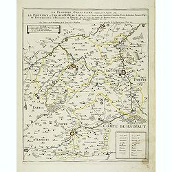
La Flandre Gallicane conquise par le Roy Lan c'est-à-dire La Province ou Chastellenie de Lille. . .
Scarce and detailed map of northern France, centered on Lille with title along the top. The map is dated 1667 and has the address "…proche le Fort l'Euesque, sur l...
Date: Paris, 1667
Selling price: ????
Please login to see price!
Sold
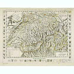
Les XIII Cantons Suisses Suivant le temps de leur Ligue . . .
Detailed map of thirteen Swiss counties with title at top. Coats of arms to the left, right and bottom. In bottom a key and a scale in French and Swiss miles.Engraved by ...
Date: Paris, 1667
Selling price: ????
Please login to see price!
Sold
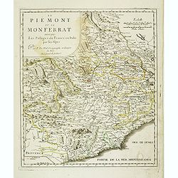
Le Piemont et le Monferrant avec que les Passage de France en Italie par Les Alpes . . .
Detailed map of the provinces Piedmont and Montferrat in Italy. Centered on Turin.
Date: Paris, 1667
Selling price: ????
Please login to see price!
Sold in 2021
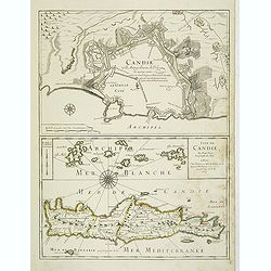
Candie ville metropolitaine de l'Isle de même nom . . . Isle de Candie . . .
Two maps on one sheet: In top Crete's metropolitan town Heraklion with a descriptive text inside the town "Candie ville metropolitaine de méme nom soûmise au grand...
Date: Paris, 1667
Selling price: ????
Please login to see price!
Sold in 2012
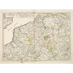
Picardie et les Pays Bas Catoliques &c. . .
Covering southern part of the Netherlands, Belgium and northern part of France. Engraved by R.Cordier Abbauil.Nicolas Sanson was to bring about the rise of French cartogr...
Date: Paris, 1667
Selling price: ????
Please login to see price!
Sold in 2014
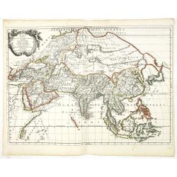
Asia Vetus.
A fine map of the ancient continent of Asia.This edition carries the date 1667.Nicolas Sanson was to bring about the rise of French cartography, although the fierce compe...
Date: Paris, 1667
Selling price: ????
Please login to see price!
Sold in 2013
Graecia Foederata sub Agamemnone, ob Helenae Raptum in Troiam coniurans . . .
A fine map of the ancient Greece. Engraved by Ludovicus Cordier. Nicolas Sanson was to bring about the rise of French cartography, although the fierce competition of the ...
Date: Paris, 1667
Selling price: ????
Please login to see price!
Sold in 2013
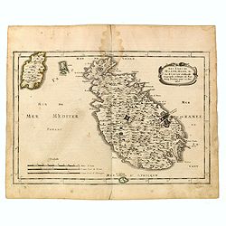
Les isles de Malte, Goze, & C. / par N. Sanson dªAbbeville, geographe ordinaire du Roy. . .
Map of Malta and Goza prepared by N.Sanson and published by Pierre Mariette.Published in an early edition of the small Sanson atlas L'Europe Dediée a Monseigneur . . . L...
Date: Paris, P. Mariette, 1667
Selling price: ????
Please login to see price!
Sold in 2015
![[Title page] Nieut Kaert-boeck, vande XVII Nederlandse Provincie Perfecter als ooyt voor desen, Begrypende mede de aengrensende Landen . . .](/uploads/cache/35975-250x250.jpg)
[Title page] Nieut Kaert-boeck, vande XVII Nederlandse Provincie Perfecter als ooyt voor desen, Begrypende mede de aengrensende Landen . . .
Title page to De Wit's atlas of the Dutch Seventeen provinces, first published in 1667. In bottom showing De Wit's name spelled "De Widt" , a practice discontin...
Date: Amsterdam, ca. 1667
Selling price: ????
Please login to see price!
Sold in 2020
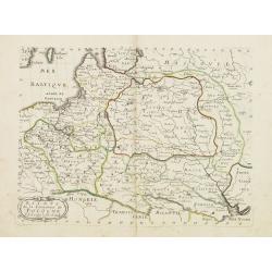
Hongrie.
Rare map of Hungary published by Jollain in 1667. Published in "Trésor Des Cartes Geographiques Des Principaux Estats de Lunivers". This atlas was based upon B...
Date: Paris, 1667
Selling price: ????
Please login to see price!
Sold in 2019
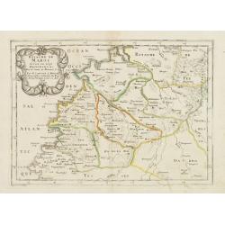
Le Royaume de Marroc.
Rare map of Morocco published by Jollain in 1667. Published in "Trésor Des Cartes Geographiques Des Principaux Estats de Lunivers". This atlas is based upon B...
Date: Paris, 1667
Selling price: ????
Please login to see price!
Sold in 2016
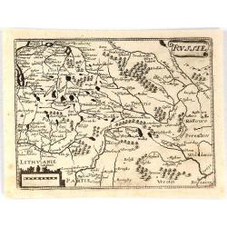
Russie.
Rare map of Russia published by Jollain in 1667. Published in "Trésor Des Cartes Geographiques Des Principaux Estats de Lunivers". This atlas is based upon Bo...
Date: Paris, 1667
Selling price: ????
Please login to see price!
Sold in 2018