Browse Listings in World Maps
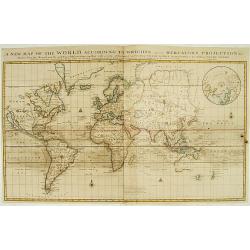
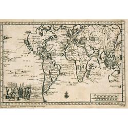
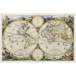
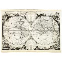
A new map of the world according to the New Observations..
A world map in Mercator projection, showing California as an island. In right hand corner smaller inset of the North Pole.From Harris, A complete collection of Voyages an...
Date: London 1705
Selling price: ????
Please login to see price!
Sold
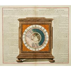
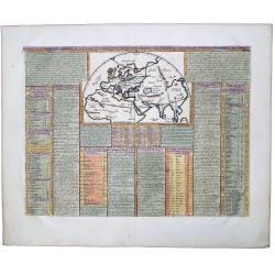
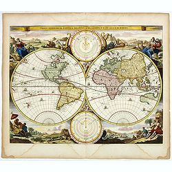
Geographische Universal-Zeig und Slag-Uhr.
An unrecorded, separately published sheet in order to explain the use and promote the newly invented clock showing the different times around the world.The world centered...
Date: Nuremberg, 1705
Selling price: ????
Please login to see price!
Sold in 2013
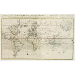
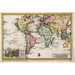
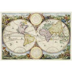
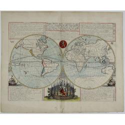
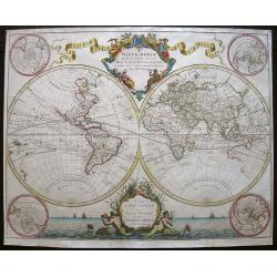
A new map of the world according to Wrights alias Mercator Projection &c..
A Large, almost wall map of the world map in Mercator projection, showing California as an island. In right hand corner smaller inset of the North Pole.From Harris, A com...
Date: London, 1705
Selling price: ????
Please login to see price!
Sold in 2008
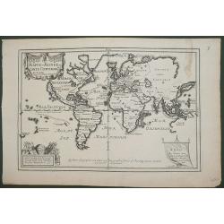
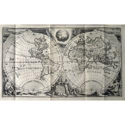
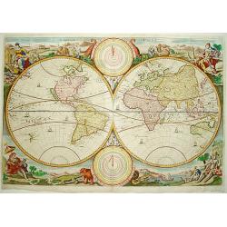
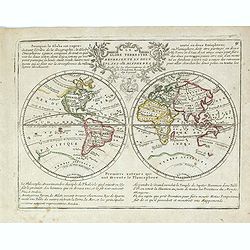
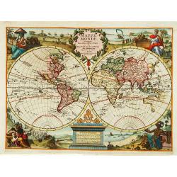
MAPPE-MONDE ou CARTE UNIVERSELL
An attractive map on the Mercator projection which has a number of interesting features. California is shown as an Island and New Guinea is joined to the mainland of Aust...
Date: Paris, 1705
Selling price: ????
Please login to see price!
Sold in 2015
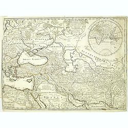
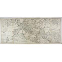
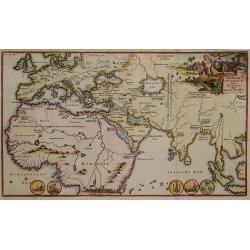
Theatrum Historicum. . . Romani tu Barbarorum. . . Pars Orientalis. . .
Showing the Roman Empire by G. de l'Isle, French cartographer, pupil of Cassini, called Father of Modern Geography. In upper right hand corner eastern hemisphere includin...
Date: Paris, 1705
Selling price: ????
Please login to see price!
Sold in 2012
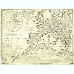
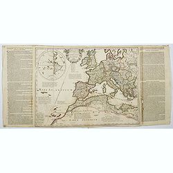
Theatrum Historicum. . . Romani tu Barbarorum. . . Pars Occidentalis. . .
Showing the Roman Empire by G. de l'Isle, French cartographer, pupil of Cassini, called Father of Modern Geography. In upper left hand corner western hemisphere.Centered ...
Date: Paris, 1705
Selling price: ????
Please login to see price!
Sold in 2012
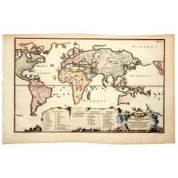
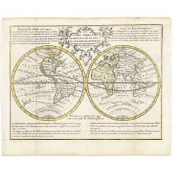
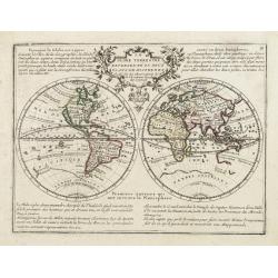
Plan de l\' Histoire Universelle, oulon voit les quatre Monarchies du Monde , et tous les Anciens Etats, aussi bien que ceux qui subsistent aujourdhuy.
Interesting map of the Eastern Hemisphere, with an inset of the Western Hemisphere showing California as and Island. The main map shows the extents of the Roman and Alexa...
Date: Amsterdam, c. 1705
Selling price: ????
Please login to see price!
Sold in 2015
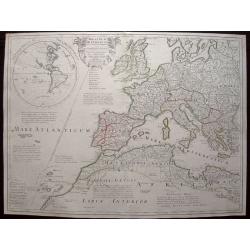
Theatrum Historicum .. Romani tu Barbarorum.. Pars Occidentalis..
Engraved map in outline color. Shows forested areas, etc. Relief shown pictorially. Covers Europe and most of North Africa. Includes inset map of the western hemisphere, ...
Date: Paris, 1705
Selling price: ????
Please login to see price!
Sold in 2014
Theatrum Historicum (and) An Historical Map of the Roman Empire. . .
A large map of Europe, the Mediterranean, North Africa and parts of the Middle East with inset double hemisphere world map, dated 1705. Map is finely engraved with a prof...
Date: Paris, 1705
Selling price: ????
Please login to see price!
Sold in 2020
Theatrum Historicum. . . Romani tu Barbarorum. . . Pars Occidentalis. . .
Showing the Roman Empire by G. de l'Isle, French cartographer, and pupil of Cassini, called Father of Modern Geography. In the upper left-hand corner western hemisphere.C...
Date: Paris, 1705
Selling price: ????
Please login to see price!
Sold in 2022
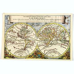
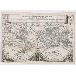
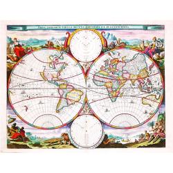
Algemeene Wereldkaart van den Aardkloot. In twee Vlakronden vertoont, en naar de niewste Beschryvingen overzein en verbetert. . .
This delightful double hemisphere map is beautifully decorated with clouds at the top and excellent allegorical representations of the known continents at the bottom. Cal...
Date: Amsterdam, ca 1705
Selling price: ????
Please login to see price!
Sold in 2019
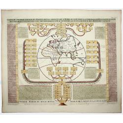
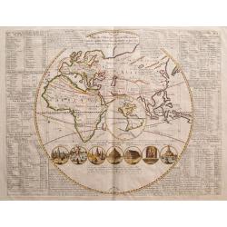
CARTE DU PREMIER PERIODE DU MONDE DEPUIS ADAM JUSQU'A MOISE OU L'ON VOIT LA CHRONOLOGIE. . .
A fascinating engraving depicting a map of the Old World surrounded and keyed to a Biblical genealogical family tree. Panels at side provide an historical timeline for th...
Date: Amsterdam, 1705
Selling price: ????
Please login to see price!
Sold in 2020
Carte pour servie a l'inteligence de l'histoire de la Cronologie, et de la Geographie des Empires des Assiriens, des Perses, des Egiptiens, et des Chinois.
An interesting sheet with a map of the classical world showing the empires of the Assyrians, Persians, Egyptians and Chinese, with descriptive French text, from Chatelain...
Date: Amsterdam, 1705
Selling price: ????
Please login to see price!
Sold in 2020
Algemeene Wereldkaart van den Aardkloot. In twee Vlakronden vertoont, en naar de niewste Beschryvingen overzein en verbetert. . .
This delightful double hemisphere map is beautifully decorated with clouds at the top and excellent allegorical representations of the known continents at the bottom. Cal...
Date: Amsterdam/ Utrecht, ca 1705
Selling price: ????
Please login to see price!
Sold in 2020
Scheeps-Togt door Ferdinand Magellaan. . .
A beautiful map illustrating the great voyage of Ferdinand Magellan from Spain, through the Straits of Magellan, through the Pacific, until Southeast Asia. The maps shows...
Date: Leiden, ca 1706
Selling price: ????
Please login to see price!
Sold in 2019
Zee-Togten door Thomas Candys na de West Indien en van daar rondom den gantzen Arrdkloot gedaan.
Pieter van der Aa was a prolific publisher. He published a.o. '' Naaukeurige versameling der gedenkwaardigste zee- en land-reysen'', a series of accounts of voyages (1706...
Date: Leiden, 1707
Selling price: ????
Please login to see price!
Sold
F.Draakx Ship-Vaart door de Straat en Zuyd-Zee ...
Most decorative and scarce item, showing a world map in Mercator projection. In lower part a title cartouche with Francis Drake.California, as an island, with flat northe...
Date: Leiden, 1707
Selling price: ????
Please login to see price!
Sold in 2009
F. Draakx Schip-vaart door de Straat en Zuyd Zee.
An attractive world map in Mercator projection,showing the circumnavigation of Francis Drake. Embellished with a decorative title-cartouche. Pieter van der Aa was a proli...
Date: Leiden, 1707
Selling price: ????
Please login to see price!
Sold in 2019
Mappe-Monde pour connoitre les progres & les conquestes...
Unusual double hemisphere map with California as an Island. French text describes the expeditions and colonial possessions of the Dutch East India Company.The map origina...
Date: Amsterdam, ca 1707
Selling price: ????
Please login to see price!
Sold in 2017
De tweede Weereld door Noachs dry Zonen bevolkt.
Charming Bible map showing the world as known after the Great Flood with Europe and parts of Asia and Africa. Title cartouche depicts Noah and his sons.
Date: Utrecht 1709
Selling price: ????
Please login to see price!
Sold
TOTIUS ORBIS TERRARUM Tabula, Ejusque post diluvium divisio inter filios noachi.
An extremely scarce world map by Joseph Moxon's son James and published featuring a curious separation of California from the rest of North America.The map clearly provid...
Date: Amsterdam, 1709
Selling price: ????
Please login to see price!
Sold in 2019
![TOTIUS ORBIS TERRARUM Tabula, Ejusque post diluvium divisio inter filios noachi.[California Island]](/uploads/cache/83666-250x250.jpg)
TOTIUS ORBIS TERRARUM Tabula, Ejusque post diluvium divisio inter filios noachi.[California Island]
An extremely scarce world map by Joseph Moxon's son James, and published featuring a curious separation of California from the rest of North America. The map clearly prov...
Date: Amsterdam, 1709
Selling price: ????
Please login to see price!
Sold in 2020
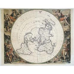
Imago Totius Orbis..
A very graphic map of the world on a north polar projection. Surrounding the lands are two astronomical round diagrams, eight classic wind heads usually seen on 16th cent...
Date: Munich ca. 1710
Selling price: ????
Please login to see price!
Sold
Werelt Caert
Beautiful double hemisphere from a Dutch Bible. Surrounded by allegorical representations of the continents, based on Visscher. CALIFORNIA AS AN ISLAND with a flat northe...
Date: Dordrecht 1710
Selling price: ????
Please login to see price!
Sold
Werelt Caert. Orbis terrarum
Lovely double hemisphere map from a Dutch Bible. Title inside the surrounding allegorical representations of the continents, based on Visscher. CALIFORNIA IS AN ISLAND wi...
Date: Amsterdam 1710
Selling price: ????
Please login to see price!
Sold in 2009
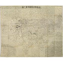
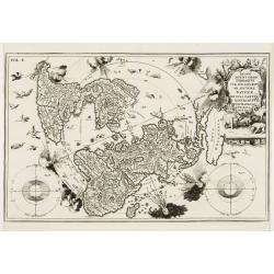
Nansenbushu bankoku shoka no zu.
This map is a great example of Japanese world maps representing Buddhist cosmology with real-world cartography. It is the earliest one and - therefore - the prototype for...
Date: Kyoto, 1710
Selling price: ????
Please login to see price!
Sold in 2010
Orbis Terrarum Nova et Accuratissima Tabula.
Superb elaborate double-hemisphere copper engraved map of the world. Shows California as an island, large "Compagnies Land" between the Asian and American cont...
Date: Leiden, c. 1710
Selling price: ????
Please login to see price!
Sold in 2011
![Nansenbushu Bankoku Shoka No Zu [Outline Map of All Countries of the Universe]](/uploads/cache/93929-250x250.jpg)
Nansenbushu Bankoku Shoka No Zu [Outline Map of All Countries of the Universe]
This map issued by Bundaiken Uhei is a great example for Japanese world maps representing Buddhist cosmology with real world cartography. It is the earliest one and - the...
Date: Kyoto, (Hoei 7 = Year of the Tiger) or 1710
Selling price: ????
Please login to see price!
Sold in 2014
![[World Polar Projection with insular California.]](/uploads/cache/95897-250x250.jpg)
[World Polar Projection with insular California.]
Original copper engraved map; page size 27 x 40 cm; from: 'Atlas Novus...Part III...Atlas Marianus'.A beautifully engraved world map on a North polar projection which is ...
Date: Munich, ca. 1710
Selling price: ????
Please login to see price!
Sold in 2017
Theatrum historicum ad Annum Christi Quadringentesimum...
A striking map of the world from the time of the Roman Empire. Dating from the 8th century, the Roman empire expanded to become one of the largest empires in the ancient...
Date: Paris, 1710
Selling price: ????
Please login to see price!
Sold in 2018
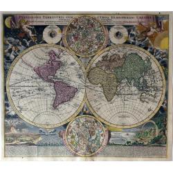
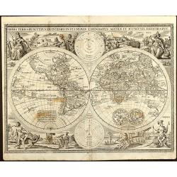
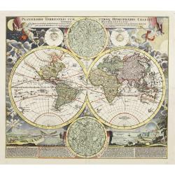
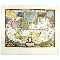
Planiglobii Terrestris Cum Utroq Hemisphaerio Caelesti Generalis Exhibitio..
Intriguing and spectacular world map, one of the most decorative world maps of the eighteenth century. This is the first edition of J.B. Homann's double hemisphere map, w...
Date: Nuremberg, 1710
Selling price: ????
Please login to see price!
Sold in 2021
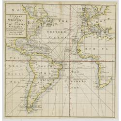
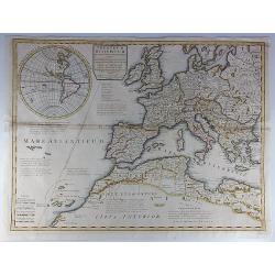
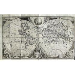
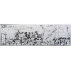
A Chart of the Western and Southern Oceans.
Copper engraved chart of the Atlantic showing the eastern part of North America, all of South America, and most of Europe and Africa. The tract of the voyage of John Narb...
Date: London, 1711
Selling price: ????
Please login to see price!
Sold
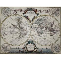
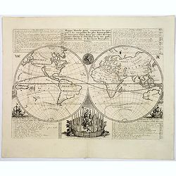
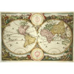
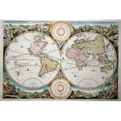
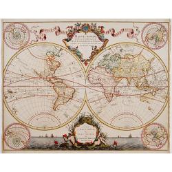
Mappe-Monde Dresse sur les Observations de Mrs. de l'Academie Royale des Sciences. . .
World map by M. de L'Isle, published by Pierre Mortier 1705-1711. A double hemisphere world map with four polar views showing the world from various angles in the corners...
Date: Amsterdam, 1705-1711
Selling price: ????
Please login to see price!
Sold in 2021
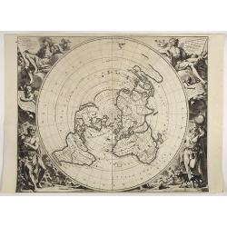
Planisphere Terrestre, Suivant les nouvelles Observations des Astronomes.
Beyond its sheer beauty, this North Polar projection or azimuthal, equidistant world map represents an important step in the history of mapping. Karpinski considers it's ...
Date: Leiden, 1713
Selling price: ????
Please login to see price!
Sold in 2018
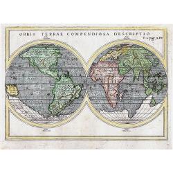
ORBIS TERRAE COMPENDIOSA DESCRIPTIO
Attractive double-hemisphere map of the world based on Mercator\'s monumental map from 1587. It first appeared in Rosaccio\'s 1598 edition of Ptolemy\'s Geographia and wa...
Date: Venice, 1713
Selling price: ????
Please login to see price!
Sold in 2011
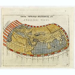
Orbis Veteris Descriptio, seu Ptolemaei Typus.
A Ptolemaic map engraved by Giovanni Antonio Magini. The landlocked Indian Ocean contains a huge Toprobana (present day Sri Lanka) and a virtually nonexistent Indian subc...
Date: Padua, 1713
Selling price: ????
Please login to see price!
Sold in 2015
Orbis Veteris Descriptio, seu Ptolemaei Typus.
Ptolemaic map of the old world, showing the Indian Ocean surrounded by land! With a huge Toprobana (present day Sri Lanka) and a virtually nonexistent Indian subcontinent...
Date: Padova, c. 1713
Selling price: ????
Please login to see price!
Sold in 2015
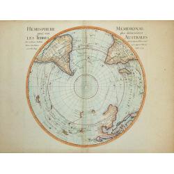
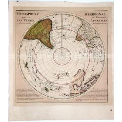
Hemisphere Meridional pour voir plus distinctement les Terres Australes
Map of the Southern Hemisphere with many voyage routes, including Magellan, Halley, Dampier and Tasman. A number of islands have only recently been discovered and are sho...
Date: Paris, 1714
Selling price: ????
Please login to see price!
Sold in 2008
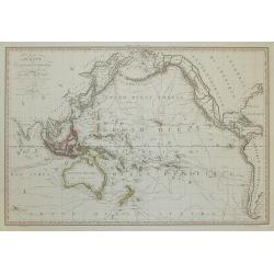
Océanie, ou Australasie et Polynésie . .
Beautiful large map of the Pacific Ocean. The many discoveries in the late 18th century in the northern part of North America and elsewhere have been incorporated, and t...
Date: Paris, 1714
Selling price: ????
Please login to see price!
Sold in 2008
Orbis Terrarum Tabula Recens Emendata Et In Lucem Edita.
A world map in two hemispheres, decorated in the corners with the representations of the four continents in allegorical form.
Date: Amsterdam / Dordrecht, 1714
Selling price: ????
Please login to see price!
Sold in 2021
Orbis Terrarum Tabula Recens Emendata et in Lucem Edita.
Beautiful double hemisphere world map from a folio Dutch Bible published by Pieter Keur and Pieter Rotterdam and Pieter Rotterdam de Jonge.Surrounded by fabulous scenes f...
Date: Amsterdam, 1714
Selling price: ????
Please login to see price!
Sold in 2019
Hemisphere Pour Voir Les Terres Meridionale Plus Distinctement Australes.
This beautiful map depicts the explorations and discoveries made by Portuguese, Spanish, Dutch and English explorers in Australia, New Zealand and the South Pacific made ...
Date: Amsterdam, 1714
Selling price: ????
Please login to see price!
Sold in 2021
Orbis Terrarum Nova et Accuratissima Tabula
Superb double-hemisphere copper engraved map of the world. Shows California as an island, large \"Compagnies Land\" between the Asian and American continents, a...
Date: Leiden, c1715
Selling price: ????
Please login to see price!
Sold in 2008
Planisphere Terrestre Suivant les nouvelle Observations des Astronomes Dressee et presente Roy Tres Chretien par Mr. Cassini...
Karpinski considers this the first strictly scientific map of the world. This was the first map to set standard longitudes for known places based on scientific calculatio...
Date: Leiden, c. 1715
Selling price: ????
Please login to see price!
Sold in 2016
![[Title page] Planisphere representant tout e l'etendue du monde. . .](/uploads/cache/31980-250x250.jpg)
[Title page] Planisphere representant tout e l'etendue du monde. . .
Atlas carries a north polar azimuthal projection on his shoulders. This projection with equidistant concentric circle of latitude was claimed by Louis de Mayerne Turquet....
Date: Amsterdam, 1715
Selling price: ????
Please login to see price!
Sold in 2012
Voyage du Cap.e Dampier, A la N.Hollande &c en 1699 &c.
Uncommon map of the route of Captain William Dampier on the HMS Roebuck. He sailed to Australia, Timor, New Guinea, and discovered New Britain. Australia is shown with un...
Date: Rouen, 1715
Selling price: ????
Please login to see price!
Sold in 2017
Orbis Terrarum Typus de Integro in Plurimis Emendatus Auctus et Icunculis Illustratus
Outstanding and rare example of a bible world map based on the Visscher bible map from 1657 (Shirley 401/414). This map is larger in size and has an extra engraved frame ...
Date: Minden, 1716
Selling price: ????
Please login to see price!
Sold in 2008
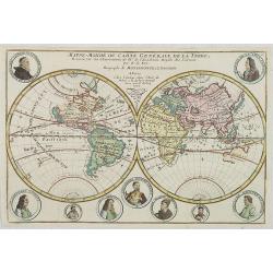
Mappe-Monde ou Carte Generale de la Terre..
Nice double hemisphere world map surrounded by medallion portraits of important explorers, including Columbus, La Salle, Magellan, Drake, Père Tachard, Dampier, Vespucci...
Date: Paris, 1717
Selling price: ????
Please login to see price!
Sold in 2012
Werelt Caert.
Beautiful double hemisphere from a Dutch Bible. Surrounded by allegorical representations of the continents, based on Visscher. CALIFORNIA IS AN ISLAND with a flat northe...
Date: Amsterdam 1719
Selling price: ????
Please login to see price!
Sold
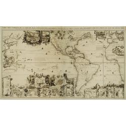
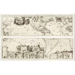
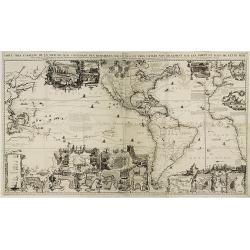
Carte très curieuse de la Mer du Sud, contenant des remarque..
One of the most spectacular examples of the marriage between cartography and graphic art.Based on de Fer's map of 1713. One map on 4 sheets, showing America in the middle...
Date: Amsterdam 1719
Selling price: ????
Please login to see price!
Sold in 2008
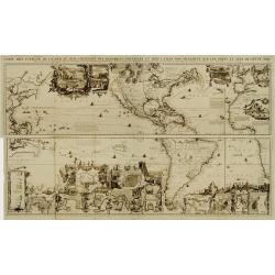
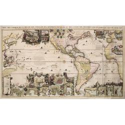
Carte très curieuse de la Mer du Sud, contenant des remarque..
Based on de Fer's map of 1713. One map on 4 sheets, showing America in the middle with Europe on one side and the Pacific with Japan and China on the other. Top sheets of...
Date: Amsterdam 1719
Selling price: ????
Please login to see price!
Sold
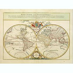
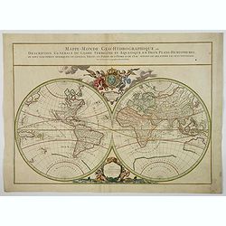
Mappe-Monde Geo-Hydrographique, ou Description Generale...
MAP OF THE WORLD DEDICATED TO THE KING. Large map of the world in two hemispheres, in a stereographic projection. California seems to be connected to the mainland, rather...
Date: Paris, 1719
Selling price: ????
Please login to see price!
Sold in 2013
Werelt Caert.
Beautiful double hemisphere from a Dutch Bible. Surrounded by allegorical representations of the continents, based on Visscher.California is an island with a flat norther...
Date: Amsterdam 1719
Selling price: ????
Please login to see price!
Sold
Carte très curieuse de la Mer du Sud, contenant des remarque..
Based on de Fer's map of 1713. One map on 4 sheets, showing America in the middle with Europe on one side and the Pacific with Japan and China on the other. Top sheets of...
Date: Amsterdam 1719
Selling price: ????
Please login to see price!
Sold

Werelt Caert
Beautiful double hemisphere from a Dutch Bible. Surrounded by allegorical representations of the continents, based on Visscher. CALIFORNIA AS AN ISLAND with a flat northe...
Date: Dordrecht 1719
Selling price: ????
Please login to see price!
Sold
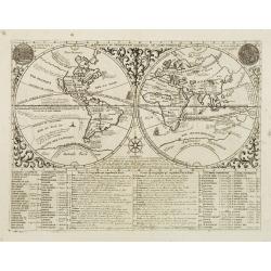
Mapmonde ou Description Genrale Du Globe Terrestre.
Double hemispherical world map with descipitive text showing California as an island, tracks of several explorers around the world and Celestial images of the sun accordi...
Date: Amsterdam, 1719
Selling price: ????
Please login to see price!
Sold in 2008
Werelt Caert. . .
Lovely double hemisphere map from a Dutch Bible. Title inside the surrounding allegorical representations of the continents, based on Visscher. CALIFORNIA IS AN ISLAND wi...
Date: Amsterdam, 1719
Selling price: ????
Please login to see price!
Sold in 2011
Le Globe Terrestre Representé en Deux Plans-Hemispheres..
Small double hemisphere world map featuring the Island of California and a Northwest Passage. There is little interior detail with only major nations named.Ter. de Jesso ...
Date: Paris, 1719
Selling price: ????
Please login to see price!
Sold in 2011
Carte Très Curieuse De La Mer Du Sud Contenant Des Remarques Nouvelles Et Tres Utiles . . .
Based on de Fer's map of 1713. One map on 4 sheets, showing America in the middle with Europe on one side and the Pacific with Japan and China on the other. Showing the v...
Date: Amsterdam, 1719
Selling price: ????
Please login to see price!
Sold in 2011
Carte Très Curieuse De La Mer Du Sud Contenant Des Remarques Nouvelles Et Tres Utiles Non Seulement Sur Les Ports et Isles de Cette Mer .
Based on de Fer's wall map of 1713. One map on 4 sheets, showing America in the middle with Europe on one side and the Pacific with Japan and China on the other. Top shee...
Date: Amsterdam, 1719
Selling price: ????
Please login to see price!
Sold in 2022
Le Globe Terrestre Representé en Deux Plans-Hemispheres..
Small double hemisphere world map featuring the Island of California and a Northwest Passage. There is little interior detail with only major nations named.Ter. de Jesso ...
Date: Paris, 1719
Selling price: ????
Please login to see price!
Sold
Werelt Caert
Lovely double hemisphere map from a Dutch Bible. Title inside the surrounding allegorical representations of the continents, based on Visscher. CALIFORNIA IS AN ISLAND wi...
Date: Amsterdam, 1719
Selling price: ????
Please login to see price!
Sold in 2013
Le Globe Terrestre Representé en Deux Plans-Hemispheres..
Small double hemisphere world map featuring the Island of California and a Northwest Passage. There is little interior detail with only major nations named.Ter. de Jesso ...
Date: Paris, 1719
Selling price: ????
Please login to see price!
Sold in 2021
Carte tres Curieuse de la Mer du Sud... (southern sheet only)
The bottom half of Chatelain's famous and highly decorative map. Extends to show a partial Australia with dates of discoveries, the Pacific Ocean, South America, the Sout...
Date: Amsterdam, 1719
Selling price: ????
Please login to see price!
Sold in 2017
MAPPE-MONDE pour connoitre les progrès & les conquestes les plus Remarquables des Provinces-Unies...
The voyages and discoveries of the Dutch East India and Dutch West India Companies are the subject of this handsome, double-hemisphere map of the world.The map shows an i...
Date: Amsterdam, 1719
Selling price: ????
Please login to see price!
Sold in 2020
Mappe-Monde Geo-Hydrographique, ou Description Generale. . .
MAP OF THE WORLD DEDICATED TO THE KING. Large map of the world in two hemispheres, in a stereographic projection. California is connected to the mainland, rather than app...
Date: Paris, 1719
Selling price: ????
Please login to see price!
Sold in 2023
Nova delineatio Orbis Terrarum..
Very decorative with double hemispheres surrounded by six figures representing earth, fire, water, day and night. Shows California as an island. Based on Colom's rare 165...
Date: Leiden 1720
Selling price: ????
Please login to see price!
Sold
Der Neuen Welt.. / Der Alte Welt..
Two maps on one sheet, showing eastern and western hemisphere. In each corner portrait of important explorers: Columbus, Drake, Vespucci, Magalhaes, Schouten, Dampier, Ta...
Date: Augsburg 1720
Selling price: ????
Please login to see price!
Sold
Den AARDBODEM na de Zundvloed door NOACHs dri Soonen en hare nakomelingen bevolkt.
Decorative historical world map indicating the regions where the three sons of Noach have lived. To the right is a family tree. At the bottom are several coins.
Date: The Netherlands 1720
Selling price: ????
Please login to see price!
Sold
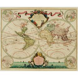
Mappe-Monde dressé sur les observations de.. par M.de L'Isle.
Guillaume de L'Isle became one of the foremost geographers of his age. He was tutored by Jean-Dominique Cassini and at the age of 25 produced a globe, maps of the four co...
Date: Amsterdam 1720
Selling price: ????
Please login to see price!
Sold
Mappe-Monde dressé sur les observations de..
Guillaume de L'Isle became one of the foremost geographers of his age. He was tutored by Jean-Dominique Cassini and at the age of 25 produced a globe, maps of the four co...
Date: Amsterdam 1720
Selling price: ????
Please login to see price!
Sold
Mappe Monde.
Decorative world map in two hemispheres. Vignettes symbolising the four continents occupy the corners: between the hemispheres there are two elaborate cartouches.
Date: Leiden 1720
Selling price: ????
Please login to see price!
Sold
Planiglobii Terrestris Cum Utroq Hemisphaerio.
This is one of the most decorative eighteenth century world maps, surrounded by vivid engravings of natural phenomena such as waterspouts, a rainbow, earthquakes, and a v...
Date: Nuremberg, ca. 1720
Selling price: ????
Please login to see price!
Sold
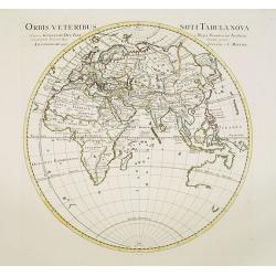
Orbis Veteribus Noti Tabula Nova.
Map of the Eastern Hemisphere, including Australia, with the tip of Diemensland. Japan's Honshu is called Satyrorum , and Kyushu Insulae Tres.The map is most interesting ...
Date: Amsterdam, 1720
Selling price: ????
Please login to see price!
Sold in 2017
Planisphaerium Terrestre../ Vlakke Aard-kloot..
Interesting and detailed world map, cartographically up-to-date and showing the routes of explorers, including Magellan, Dampier, Tasman, Gaetani and Chaumont. Nova Brita...
Date: Amsterdam, 1700 - ca.1720
Selling price: ????
Please login to see price!
Sold in 2011
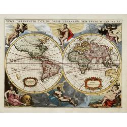
Nova Delineatio Totius Orbis Terrarum Per Petrum Vander Aa.
Originally engraved by Jacob van Meurs in 1660, and reissued here by Vander Aa, this map is based on Arnold Colom's wonderfully graphic map from the first world maritime ...
Date: Leiden, 1720
Selling price: ????
Please login to see price!
Sold in 2013
Nova delineatio Orbis Terrarum..
Very decorative with double hemispheres surrounded by six figures representing earth, fire, water, day, and night. It Shows California as an island. Based on Colom's rare...
Date: Leiden, 1720
Selling price: ????
Please login to see price!
Sold in 2013
Novus Planiglobii Terrestris per Utrumque polum conspectus.
Until recently it was believed that the Blaeu establishment produced only two world maps for its atlases -the rectangular map of 1606 and the double hemisphere of 1662. H...
Date: Amsterdam, 1720
Selling price: ????
Please login to see price!
Sold
Mappe-Monde dressé sur les observations de.. par M.de L'Isle
Guillaume de L'Isle was one of the first, in his world map, to correct the extended length of the Mediterranean, and to give back to California its true peninsular format...
Date: Amsterdam, 1720
Selling price: ????
Please login to see price!
Sold in 2016
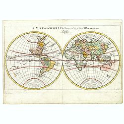
A map of the World, corrected by the latest Observations.
Map in two hemispheres, most likely after Herman Moll's "A map of the world on wch. is delineated the voyages of Robinson Curso." London, 1719 and probably prin...
Date: London, ca. 1720
Selling price: ????
Please login to see price!
Sold in 2017
